Heat Wave Ends But It's Not Going Quietly
Breaking Weather Events
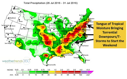
The heat wave ends today in the Mid-Atlantic but it's not going quietly. Torrential downpours and severe thunderstorms are in the forecast for today and into the weekend as deep tropical moisture streams northward out of the Gulf of Mexico. The total precipitation map below that covers this past Tuesday through this upcoming Sunday pretty much shows the moisture link from the Gulf to the Mid-Atlantic.�
�
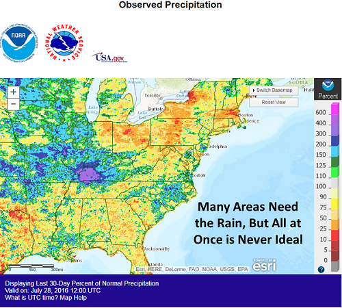
Many areas need the rain, especially NY, PA, NJ, CT, MA, LA, MS & TN. But some places, like West Virginia where excessive rainfall almost exactly a month ago resulted in devastating flooding, don't need any more rain. Heavy rain and thunderstorms are crossing the state today and will continue into the weekend. In fact, it's already been a rather wet week for some�areas across the state, so grounds are saturated which will lead to easy runoff of any additional precipitation and flooding.
�
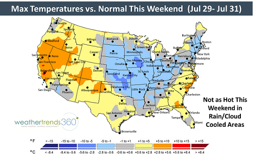
The showers and thunderstorms will be slow-movers with many areas likely seeing 1-2'' and locally higher amounts through Friday afternoon from Tennessee to the Mid-Atlantic and the I-95 corridor of southern New England. It will be a tricky night for DNC attendees and protesters alike for the final night of the DNC in Philadelphia tonight. Flash flood watches have been posted for areas from Nashville, TN to Providence, RI. The good news is that all the clouds and precipitation will knock temperatures down closer to normal for this time of year� for at least a couple of days.
�
So from heat to deluge, the weather is sure keeping us on our toes. The saga continues as we head into August: Return of the Heat!
�
Many areas need the rain, especially NY, PA, NJ, CT, MA, LA, MS & TN. But some places, like West Virginia where excessive rainfall almost exactly a month ago resulted in devastating flooding, don't need any more rain. Heavy rain and thunderstorms are crossing the state today and will continue into the weekend. In fact, it's already been a rather wet week for some�areas across the state, so grounds are saturated which will lead to easy runoff of any additional precipitation and flooding.
�
The showers and thunderstorms will be slow-movers with many areas likely seeing 1-2'' and locally higher amounts through Friday afternoon from Tennessee to the Mid-Atlantic and the I-95 corridor of southern New England. It will be a tricky night for DNC attendees and protesters alike for the final night of the DNC in Philadelphia tonight. Flash flood watches have been posted for areas from Nashville, TN to Providence, RI. The good news is that all the clouds and precipitation will knock temperatures down closer to normal for this time of year� for at least a couple of days.
�
So from heat to deluge, the weather is sure keeping us on our toes. The saga continues as we head into August: Return of the Heat!