Hurricane Harvey Brings Heavy Rain to Texas
Business
Hurricane Harvey has been reborn in the Gulf of Mexico and is on a slow track towards southeast Texas coast where he will cause significant flooding. Harvey could strengthen into a major hurricane (category 3 or higher) prior to landfall, but regardless of Harvey's classification, the primary impact will be extreme, heavy rainfall and significant flooding. In the absence of any meaningful atmospheric steering, Harvey will linger around Texas most likely through the weekend. While Harvey is the main story topping today's weather news feeds, we're also continuing to watch a tropical disturbance just off the coast of south Florida which could cause flooding in the Florida peninsula into this upcoming weekend.
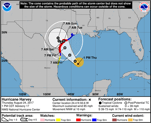
As of this afternoon, Hurricane Harvey was located in the western Gulf of Mexico and heading north-northwest towards southeast Texas. Tropical Storm-force winds could arrive along the southeast Texas coast as early as late Thursday night and early Friday morning with hurricane conditions possible early Friday evening from just southwest of Galveston down to just south of Corpus Christi. Harvey has rapidly developed throughout the day today and is expected to continue on this path of rapid intensification. It is not entirely out of the question that Harvey could attain major hurricane status. If he does and he makes landfall as a major hurricane, this would be the first major hurricane to make landfall in the U.S. since Hurricane Wilma in 2005.
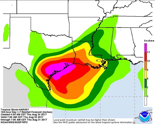
Regardless of Harvey's peak strength, the main threat will be significant flooding as Harvey and the remnants of Harvey will linger over the same areas for several days, at least through the upcoming weekend. Widespread +10'' of rain is likely across almost the entire Texas coast with amounts over 20'' not out of the question. Major Texas cities that will be impacted by flooding include (ordered with cities most likely to see flood impacts on top):
-Corpus Christi
-Brownsville
-Galveston
-Houston
-San Antonio & Austin
Residents and businesses in these areas should be taking precautionary measures NOW. Flooding from heavy rainfall and storm surge is likely. Saturated grounds in addition to strong winds will make conditions ripe for many downed trees and power lines, it is advisable that unnecessary travel ceases after today and through the weekend. Unfortunately for retailers, this means a negative impact to weekend store traffic. Expect increased store traffic today as consumers stock up on emergency supplies like plastic sheeting, plywood, bottled water, flashlights, generators, first-aid kits, and non-perishable foods. Mandatory evacuations are underway along the coastal bend of Texas.
After Harvey's initial landfall in southeast Texas either late Friday night or early Saturday morning, he won't be going anywhere fast. Harvey could re-emerge in the Gulf after spending a few days over Texas, but this forecast is low confidence. Should this occur, further threats for heavy, flooding rain will move up into Louisiana early next week.
While Hurricane Harvey is the main, immediate threat to the U.S., we are continuing to watch a tropical disturbance located near South Florida. This disturbance is producing showers and thunderstorms across South Florida and flooding is possible through the first part of the weekend. Like Harvey, this disturbance will be slow to move so heavy showers and thunderstorms will fall over some of the same areas for several days, but the rainfall totals won't be as extreme as those from Harvey with generally 2-4'' expected in South Florida.
As of this afternoon, Hurricane Harvey was located in the western Gulf of Mexico and heading north-northwest towards southeast Texas. Tropical Storm-force winds could arrive along the southeast Texas coast as early as late Thursday night and early Friday morning with hurricane conditions possible early Friday evening from just southwest of Galveston down to just south of Corpus Christi. Harvey has rapidly developed throughout the day today and is expected to continue on this path of rapid intensification. It is not entirely out of the question that Harvey could attain major hurricane status. If he does and he makes landfall as a major hurricane, this would be the first major hurricane to make landfall in the U.S. since Hurricane Wilma in 2005.
Regardless of Harvey's peak strength, the main threat will be significant flooding as Harvey and the remnants of Harvey will linger over the same areas for several days, at least through the upcoming weekend. Widespread +10'' of rain is likely across almost the entire Texas coast with amounts over 20'' not out of the question. Major Texas cities that will be impacted by flooding include (ordered with cities most likely to see flood impacts on top):
-Corpus Christi
-Brownsville
-Galveston
-Houston
-San Antonio & Austin
Residents and businesses in these areas should be taking precautionary measures NOW. Flooding from heavy rainfall and storm surge is likely. Saturated grounds in addition to strong winds will make conditions ripe for many downed trees and power lines, it is advisable that unnecessary travel ceases after today and through the weekend. Unfortunately for retailers, this means a negative impact to weekend store traffic. Expect increased store traffic today as consumers stock up on emergency supplies like plastic sheeting, plywood, bottled water, flashlights, generators, first-aid kits, and non-perishable foods. Mandatory evacuations are underway along the coastal bend of Texas.
After Harvey's initial landfall in southeast Texas either late Friday night or early Saturday morning, he won't be going anywhere fast. Harvey could re-emerge in the Gulf after spending a few days over Texas, but this forecast is low confidence. Should this occur, further threats for heavy, flooding rain will move up into Louisiana early next week.
While Hurricane Harvey is the main, immediate threat to the U.S., we are continuing to watch a tropical disturbance located near South Florida. This disturbance is producing showers and thunderstorms across South Florida and flooding is possible through the first part of the weekend. Like Harvey, this disturbance will be slow to move so heavy showers and thunderstorms will fall over some of the same areas for several days, but the rainfall totals won't be as extreme as those from Harvey with generally 2-4'' expected in South Florida.