2nd Wave of Nor'easter On The Horizon
Breaking Weather Events
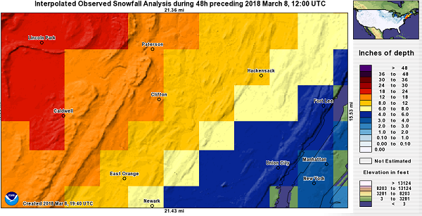
The second Nor'easter in a week is still churning away over northern New England this morning (March 8th) and finally winds down late today. Yesterday was a wild day of weather with heavy snow and even thunder from Pennsylvania to Massachusetts, including reports of thunder in both Philadelphia and New York City! The thunder came as a shock to many but was a testament to the strength of this Nor'easter. Snowfall totals topped 3' in parts of New England, although some areas felt a little gypped, like at Weather Trends International's headquarters where we only saw about 4'' of snow. Observed snowfall through 7 am March 8th below.
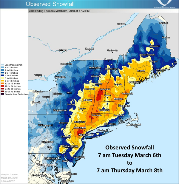
As is typical of Nor'easters, snowfall totals varied greatly over a very small distance. For example, in New York City's Central Park, 3.2'' of snow was reported, but just about 15-20 miles to their northwest, over 2' of snow! With almost every Nor'easter there are going to be areas that are surprised by how little or big their snow totals are. Unfortunately, a forecast of 0-20'' doesn't tend to go over well with the public, so meteorologists are often forced into a corner on snow accumulation forecasts. While everyone loves a pretty, easy-to-read snowfall accumulation map, the devil really is in the details. Communicating uncertainty in these types of forecasts continues to be a struggle for meteorologists, especially when social media has been flooded with forecasts from every Tom, Dick, and Harry despite their knowledge or experience in weather forecasting - All we can say is, consumers of this information beware!
Although not nearly as strong as last week's Nor'easter, this storm certainly was no wimp. Thundersnow is typically an indication of a very intense band of snow and there were several reports of this phenomena yesterday. In fact, one of NOAA's new weather satellites captured stunning image of lightning strikes from both last week's Nor'easter and this week's Nor'easter as seen below. Towards the end of the video you can see how the comma head portion of the yesterday's Nor'easter explodes with activity over Pennsylvania, New Jersey, and New York.
Now, let's all quickly catch our breath before the March Madness continues (and I'm not talking about basketball!). Although the computer forecasting models may give you whiplash if you watch them from run-to-run, the one thing they can all agree on is that there is likely to be a storm somewhere along the East Coast early next week. Whether or not you get snow, rain, or nothing at all remains to be seen, although the models tend to be favoring some snow for parts if Virginia, who have basically been snubbed by the past few storms. What happens to the storm's energy once it reaches the coast is the big question mark, a faster track out to sea would spare the Northeast for major impacts, but if the storm turns up the coast, we could be in for round 3 of March Nor'easter Madness!
As is typical of Nor'easters, snowfall totals varied greatly over a very small distance. For example, in New York City's Central Park, 3.2'' of snow was reported, but just about 15-20 miles to their northwest, over 2' of snow! With almost every Nor'easter there are going to be areas that are surprised by how little or big their snow totals are. Unfortunately, a forecast of 0-20'' doesn't tend to go over well with the public, so meteorologists are often forced into a corner on snow accumulation forecasts. While everyone loves a pretty, easy-to-read snowfall accumulation map, the devil really is in the details. Communicating uncertainty in these types of forecasts continues to be a struggle for meteorologists, especially when social media has been flooded with forecasts from every Tom, Dick, and Harry despite their knowledge or experience in weather forecasting - All we can say is, consumers of this information beware!
Although not nearly as strong as last week's Nor'easter, this storm certainly was no wimp. Thundersnow is typically an indication of a very intense band of snow and there were several reports of this phenomena yesterday. In fact, one of NOAA's new weather satellites captured stunning image of lightning strikes from both last week's Nor'easter and this week's Nor'easter as seen below. Towards the end of the video you can see how the comma head portion of the yesterday's Nor'easter explodes with activity over Pennsylvania, New Jersey, and New York.
Here's a look at the #lightning associated with the consecutive #noreaster events, captured by the sophisticated Geostationary Lightning Mapper (GLM) on NOAA's #GOES16 (#GOESEast) satellite. pic.twitter.com/bJ3313aczk
— NOAA Satellites - Public Affairs (@NOAASatellitePA) March 8, 2018
Now, let's all quickly catch our breath before the March Madness continues (and I'm not talking about basketball!). Although the computer forecasting models may give you whiplash if you watch them from run-to-run, the one thing they can all agree on is that there is likely to be a storm somewhere along the East Coast early next week. Whether or not you get snow, rain, or nothing at all remains to be seen, although the models tend to be favoring some snow for parts if Virginia, who have basically been snubbed by the past few storms. What happens to the storm's energy once it reaches the coast is the big question mark, a faster track out to sea would spare the Northeast for major impacts, but if the storm turns up the coast, we could be in for round 3 of March Nor'easter Madness!