Information About the 2017 Central Plains Ice Storms
Scientific Meteorology
Another weekend, another winter storm. This time the winter weather will be focused from the southern Plains to the Ohio Valley and parts of the Mid-Atlantic through Sunday. The good news is that the storm will be weakening as it heads east, decreasing in impact as it heads towards the Mid-Atlantic. However, significant icing will occur in the southern and central Plains with up to an inch of ice accumulation expected. This will undoubtedly cause power outages and difficult travel conditions.
Unfortunately for the 2nd weekend in a row, we're dealing with disruptive winter weather. Precipitation will fall over an extended period of time with freezing rain developing today and continuing into Sunday. An area from the Texas Panhandle to Ohio will be dealing with freezing rain for a good portion of the weekend, some ice will fall across the Ohio Valley and into the Mid-Atlantic late tonight and into Saturday including Columbus, Baltimore, Washington D.C., and Philadelphia, but the impacts there shouldn't be as severe as in the Plains.
Expect significant impacts from northern Oklahoma into Nebraska to Iowa and Missouri and parts of Illinois. Cities that will be significantly impacted by this storm include:
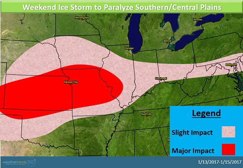
Road closures will be possible in addition to the likelihood of power outages as ice weighs down power lines and tree limbs. Just a few degrees warmer or colder will make a big difference in terms of impact on the edge of the storm for cities like Oklahoma City, Tulsa, and Cincinnati. On the northern edge of the storm, snow will mix in with sleet and freezing rain, however, the most significant impacts from this storm will be the ice.
Unfortunately for the 2nd weekend in a row, we're dealing with disruptive winter weather. Precipitation will fall over an extended period of time with freezing rain developing today and continuing into Sunday. An area from the Texas Panhandle to Ohio will be dealing with freezing rain for a good portion of the weekend, some ice will fall across the Ohio Valley and into the Mid-Atlantic late tonight and into Saturday including Columbus, Baltimore, Washington D.C., and Philadelphia, but the impacts there shouldn't be as severe as in the Plains.
Expect significant impacts from northern Oklahoma into Nebraska to Iowa and Missouri and parts of Illinois. Cities that will be significantly impacted by this storm include:
- Topeka
- Kansas City
- St. Louis
Road closures will be possible in addition to the likelihood of power outages as ice weighs down power lines and tree limbs. Just a few degrees warmer or colder will make a big difference in terms of impact on the edge of the storm for cities like Oklahoma City, Tulsa, and Cincinnati. On the northern edge of the storm, snow will mix in with sleet and freezing rain, however, the most significant impacts from this storm will be the ice.