Star Date 05 March 2018 Monday
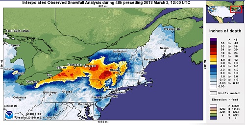
Oh boy, here we go again! It's the quiet between 2 storms as we're gearing up for yet another Nor'easter here in the Northeast. Last week, a powerful Nor'easter pummeled areas from Virginia to Maine with strong wind gusts, coastal flooding, and heavy snow, upwards of 3' in the worst-hit areas! The Nor'easter caused widespread power outages with hundreds of thousands of people still without power as of Sunday night.
We'll have little time to prepare for the next Nor'easter as it is forecast to develop off the Carolina coast on Wednesday morning and hug the Mid-Atlantic and Northeast coasts as it heads north. What this means is heavy snow for areas likely just west or very near the I-95 corridor and in northern New England with upwards of a foot of snow possible in some locations. As is always the case with these types of storm systems, the tiniest shift in the storm track will mean big changes to the forecast.
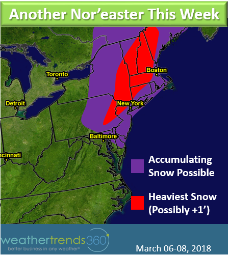
The snow will begin to fall across the Mid-Atlantic Tuesday night, but Wednesday is when the coastal low makes its closest approach and deepens. Although temperatures will be initially be marginal for snow (32F+), heavy precipitation will help to overcome the marginal temperatures, cooling the atmosphere down and resulting in snow. A rain/snow mix is more likely the closer to coast you get with lesser, if any, accumulations along the immediate coastline and several miles inland. Snow will spread into New England on Wednesday morning and pick up in intensity Wednesday afternoon.

Winds won't be anywhere near as strong as last week, expect wind gusts about half of what you saw with last week's storm. However, that does not mean we shouldn't be worried about power outages. Recent soggy conditions and weakened tree roots and limbs could, along with heavy wet snow, help to topple additional trees this week.
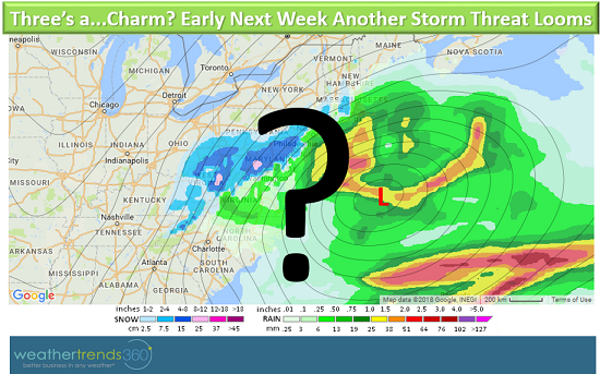
The snow wraps up in the Mid-Atlantic Wednesday night but lingers in New England through the day on Thursday. Luckily, the sun angle this time of year combined with above freezing temperatures, should help in the snow-clearing process in the days that follow. But, if you think it's safe to put away the snow blower and shovels, think again! We'rekeeping an eye on yet another potential coastal storm that could bring more snow to the Northeast during the earlier part of next week. Stay tuned!
For updates on the storm and other weather happenings like and follow us on Facebook and Twitter.