Star Date 10 November 2016 Thursday
Captain's Log
Happy Thursday...we can see the weekend from here!
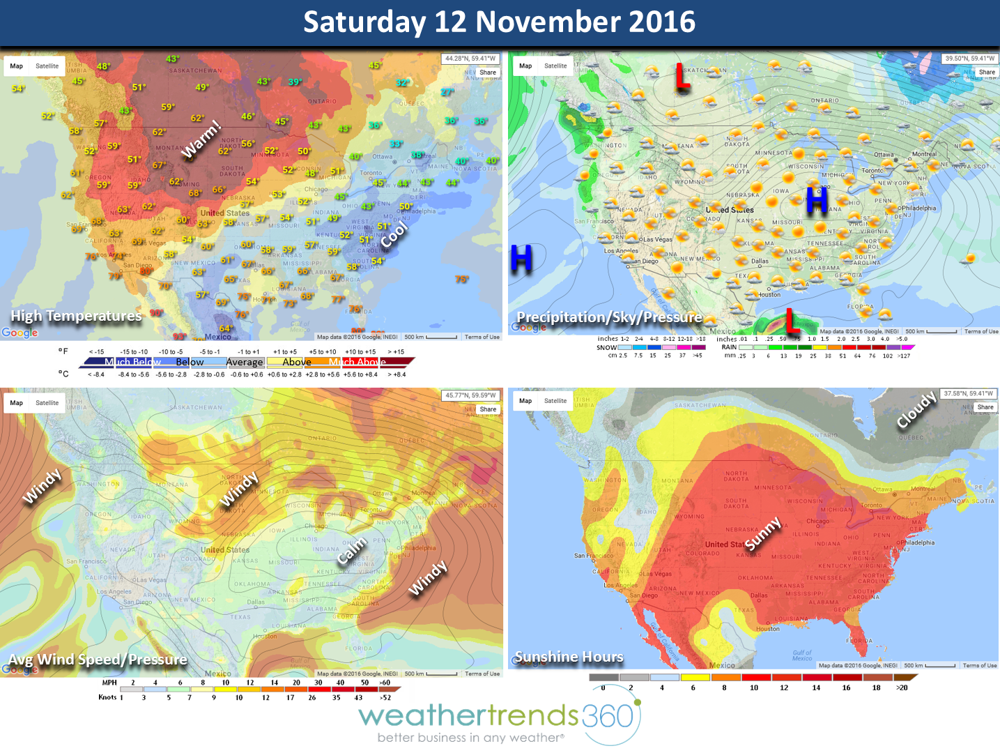
Saturday looks to be cool in the East but warm for much of the rest of the country. Most of the U.S. is dominated by a cool High Pressure in the Ohio Valley with a warm and windy return southerly flow for the Central U.S. Most of the country will have a lot of sunshine except the gloomy Pacific Northwest...they're used to it.

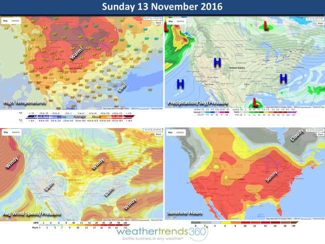
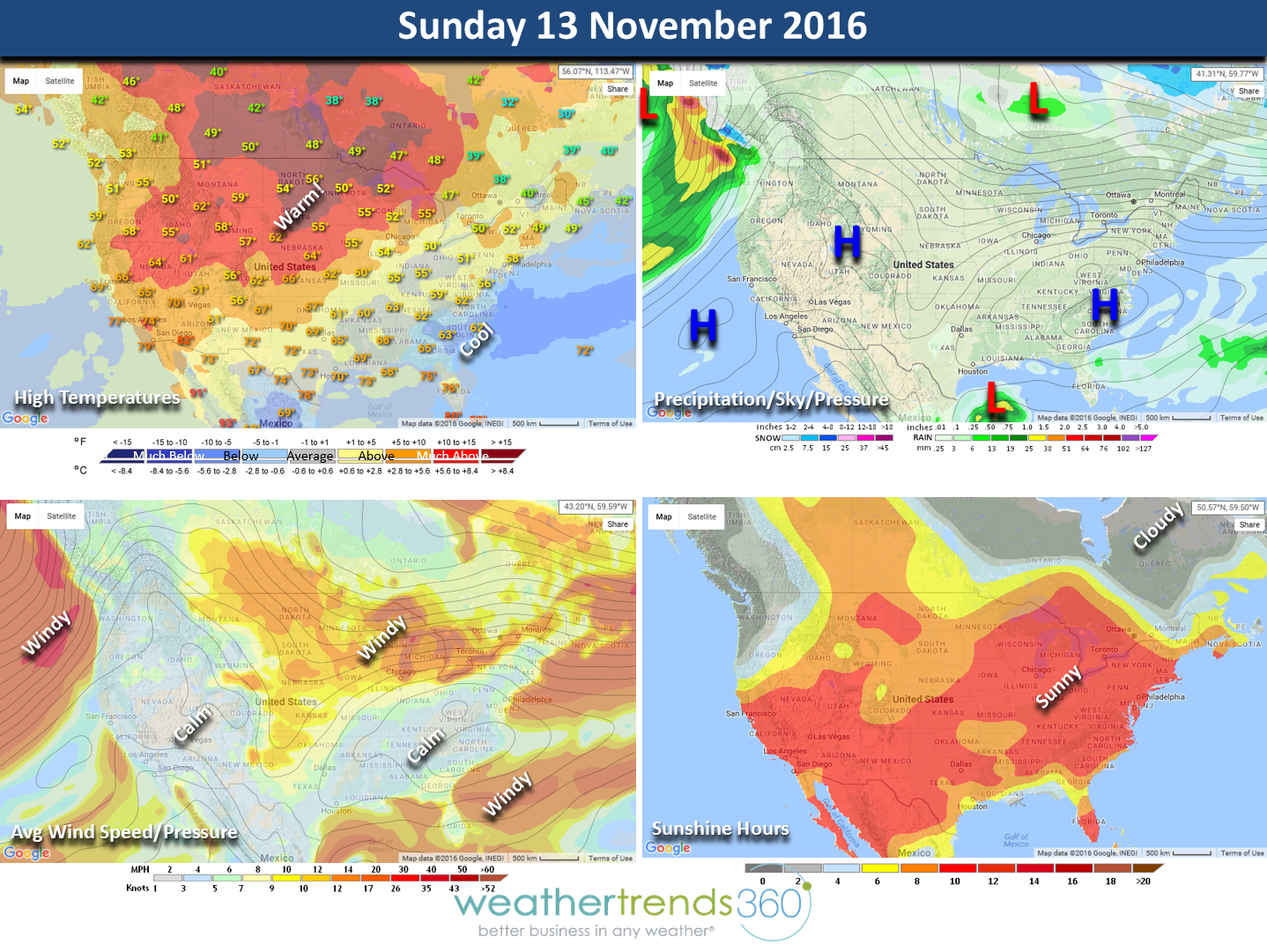
Sunday the warmer temperatures begin spreading East as the cool air with the high pressure modifies. Almost the entire country is dry. The weekend overall is the 8th warmest of the past 25 years, similar to last year. Rainfall is the #1 driest of the past 25 years so a good leaf clean up weekend. The Northeast/Middle Atlantic is the cool spot this weekend trending 7th coldest of the past 25 years while the Northern Rocky Mountains are the warmest in 18 years.
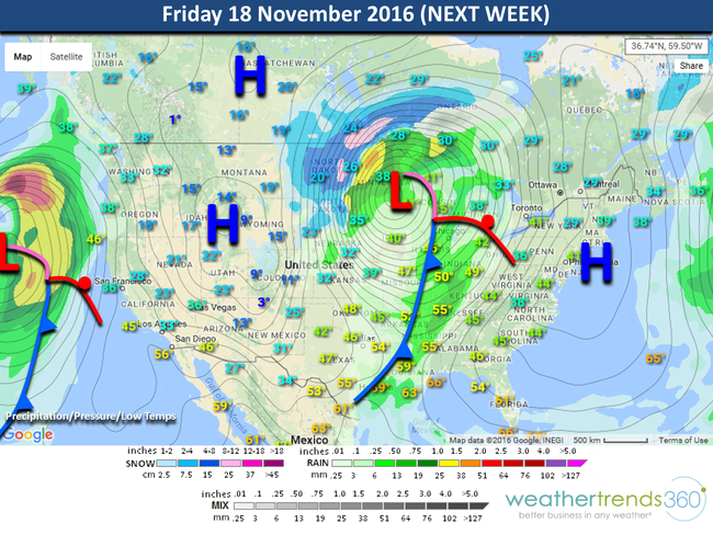
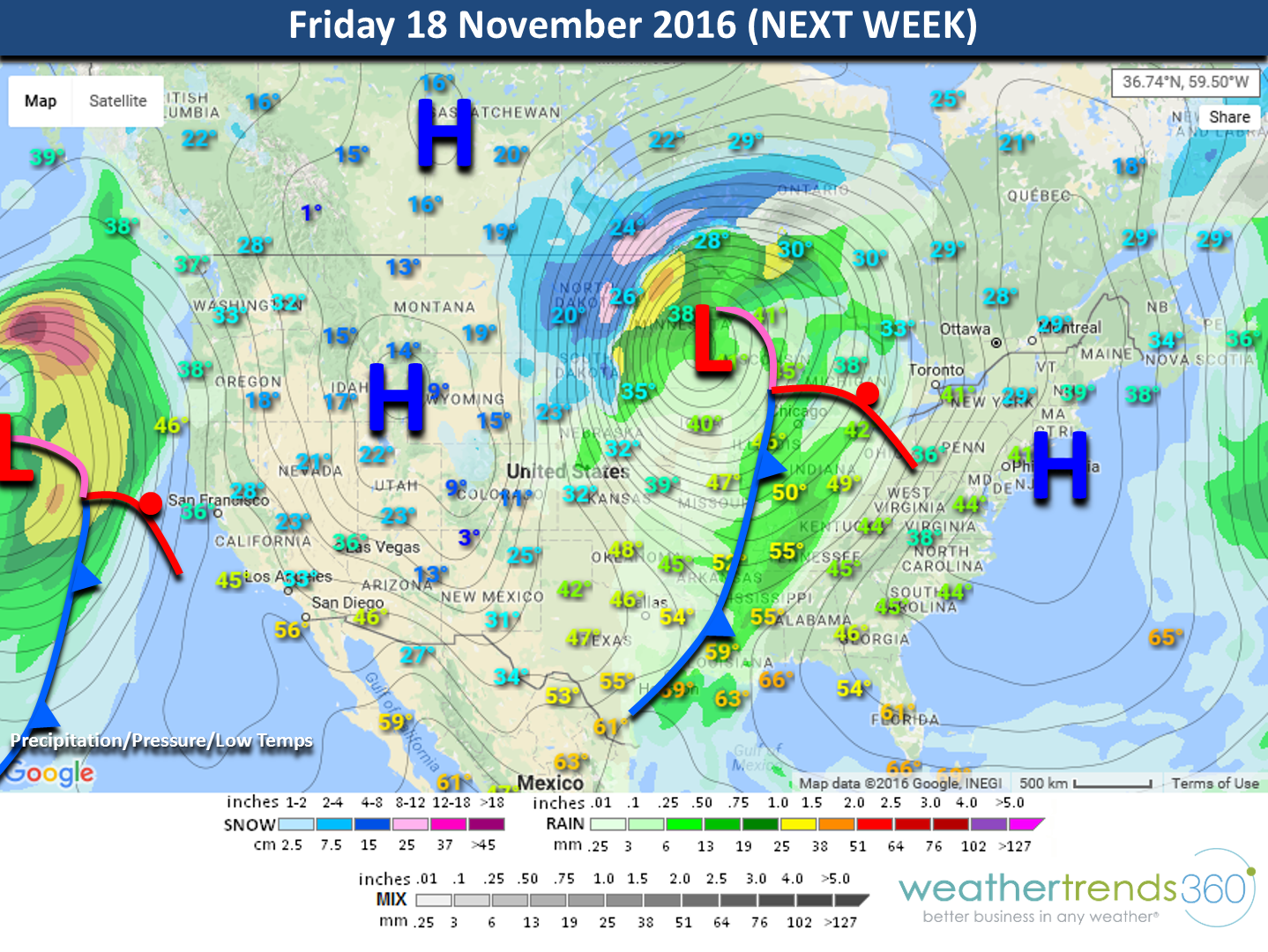
Next Week: Pattern change on the horizon and MAYBE our first bigger snow storm of the season in the Rockies, Plains and Upper Midwest next week as much colder air begins to invade the U.S. Obviously this track will change but the pattern does look to get colder and snowier as we transition into the latter half of the month into Thanksgiving weekend.
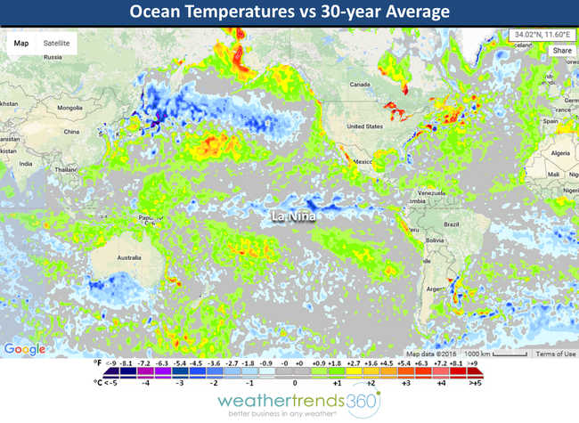
NOAA has finally declared it an official La Niña. Ocean temperatures vs the 30-year average show the colder than average water temperatures in the Equatorial Pacific. This is a weak central based La Niña and those frequently bring cold winters to the Eastern half of the U.S. when combined with 23 other cycles we factor in.
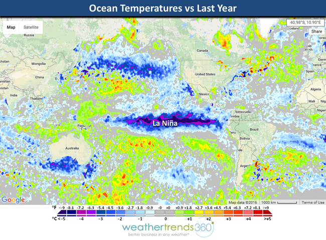
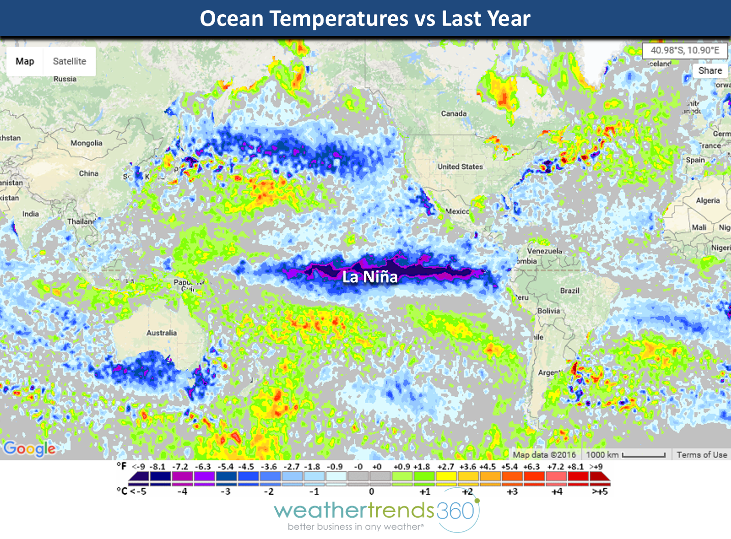
Ocean temperatures vs last year are polar opposite with most of the oceans showing much colder conditions than last year when we had the epic El Niño. Cold oceans, cold winters in the Northern Hemisphere.
Have a great weekend folks! - Capt Kirk out.
Saturday looks to be cool in the East but warm for much of the rest of the country. Most of the U.S. is dominated by a cool High Pressure in the Ohio Valley with a warm and windy return southerly flow for the Central U.S. Most of the country will have a lot of sunshine except the gloomy Pacific Northwest...they're used to it.
Sunday the warmer temperatures begin spreading East as the cool air with the high pressure modifies. Almost the entire country is dry. The weekend overall is the 8th warmest of the past 25 years, similar to last year. Rainfall is the #1 driest of the past 25 years so a good leaf clean up weekend. The Northeast/Middle Atlantic is the cool spot this weekend trending 7th coldest of the past 25 years while the Northern Rocky Mountains are the warmest in 18 years.
Next Week: Pattern change on the horizon and MAYBE our first bigger snow storm of the season in the Rockies, Plains and Upper Midwest next week as much colder air begins to invade the U.S. Obviously this track will change but the pattern does look to get colder and snowier as we transition into the latter half of the month into Thanksgiving weekend.
NOAA has finally declared it an official La Niña. Ocean temperatures vs the 30-year average show the colder than average water temperatures in the Equatorial Pacific. This is a weak central based La Niña and those frequently bring cold winters to the Eastern half of the U.S. when combined with 23 other cycles we factor in.

Ocean temperatures vs last year are polar opposite with most of the oceans showing much colder conditions than last year when we had the epic El Niño. Cold oceans, cold winters in the Northern Hemisphere.
Have a great weekend folks! - Capt Kirk out.