Star Date 10 October 2016 Monday
Captain's Log
Good morning.
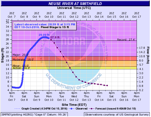
Matthew has dominated the weather headlines this past week with tragic loss of life in the U.S., Bahamas and especially Haiti. Sadly 21 died in the U.S. and upwards of a 1,000 in Haiti with estimates of $5 billion in damages in the U.S. alone. Historic flooding has been the biggest impact for the Carolina's where upwards of 15" of rain fell. To track river flood stages (many are near record high in North Carolina) visit this interactive NOAA site. Example below is the record flood (29 feet) for Smithfield, North Carolina.
Over 2.2 million homes were without power over the weekend from Florida to Virginia. Now attention turns to Nicole which should return to Cat 1, maybe 2 hurricane strength with a threat to Bermuda mid-week.
This week a strong cold front is moving into the Plains with heavy SNOW in the Northern Rocky Mountains, even into Western North Dakota early in the week. This cold air will dive into the Central U.S. with more frost and freezes for the latter half of the week in the Upper Midwest. The cooler weather will make it to the East Coast by the weekend.
Next week a big warm up takes shape for much of the country. Potentially heavy rain is possible it the Pacific Northwest and even into Northern California. Some hurricane models hint at another tropical system in the Caribbean next week so still some life in the 2016 hurricane season which runs through the end of November.
While governments haven't officially declared it La Nina, the weather pattern sure does. Equatorial surface ocean temperatures are -0.6C which is a weak central based La Nina. Equatorial sub-surface water temps are still in the -1C to -4C range so very clearly we're headed for a weak central based La Nina this Winter along with "The Blob" off Western Canada. This in theory suggests a ridge in the West (warmer) and trough in the Eastern U.S. (colder) this Winter.
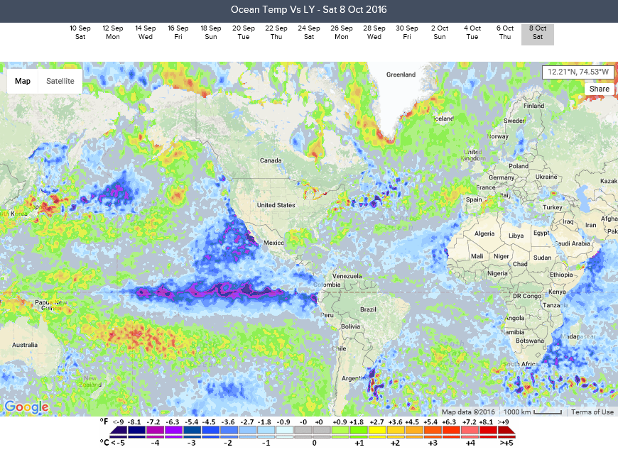
Meteorologists also like to look at early Siberian snowfall as another indicator on how the U.S. winter will play out and it appears October will end up 2nd wettest (snowiest) in 20 years and 5th coldest in 25 years with 10-15F below average temperatures across Siberia. An early snow pack across Siberia/Russia have some correlations to a colder winter in the Midwest-Northeastern U.S. We have much more frequent cold snaps from late November to April in the Great Lakes and Northeast with many Alberta Clipper type events that will bring light to moderate snowfall that will add up. The Lake Effect season should get off to a much stronger and earlier start this year as well. Not as concerned about major Nor'easters so we expect more storm as opposed to the epic storm last January. Map below shows ocean temperatures vs this time last year - there is nothing remotely close from a climate cycle perspective to the major El Nino that trumped all cycles last year.
Small businesses can sign up on-line to get their year-ahead forecasts and snowfall outlooks, etc. on our PLANS page. Our year-ahead forecasts for temperatures, rainfall, snowfall, growing degree days, heating degrees days and cooling degree days cover 21 million spots around the world out a year.

October around the world shows the Cold spots are Siberia, Europe, W. Canada and Australia. Map below shows expected October temperature trends vs last year.
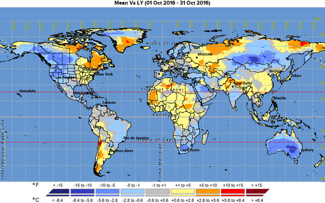
The warmer than normal spots are the Central U.S., Alaska, Brazil, W. Africa, India and China. The wet spots are the Southeast U.S., Pacific Northwest, Central Canada, China, Central Europe and Argentina. Dry spots are much of Brazil, Mexico, South Central U.S. and Alaska.
For frequent daily updates follow us on Facebook and Twitter.
Have a great week folks! - Capt Kirk out.
Matthew has dominated the weather headlines this past week with tragic loss of life in the U.S., Bahamas and especially Haiti. Sadly 21 died in the U.S. and upwards of a 1,000 in Haiti with estimates of $5 billion in damages in the U.S. alone. Historic flooding has been the biggest impact for the Carolina's where upwards of 15" of rain fell. To track river flood stages (many are near record high in North Carolina) visit this interactive NOAA site. Example below is the record flood (29 feet) for Smithfield, North Carolina.

Over 2.2 million homes were without power over the weekend from Florida to Virginia. Now attention turns to Nicole which should return to Cat 1, maybe 2 hurricane strength with a threat to Bermuda mid-week.
This week a strong cold front is moving into the Plains with heavy SNOW in the Northern Rocky Mountains, even into Western North Dakota early in the week. This cold air will dive into the Central U.S. with more frost and freezes for the latter half of the week in the Upper Midwest. The cooler weather will make it to the East Coast by the weekend.
Next week a big warm up takes shape for much of the country. Potentially heavy rain is possible it the Pacific Northwest and even into Northern California. Some hurricane models hint at another tropical system in the Caribbean next week so still some life in the 2016 hurricane season which runs through the end of November.
While governments haven't officially declared it La Nina, the weather pattern sure does. Equatorial surface ocean temperatures are -0.6C which is a weak central based La Nina. Equatorial sub-surface water temps are still in the -1C to -4C range so very clearly we're headed for a weak central based La Nina this Winter along with "The Blob" off Western Canada. This in theory suggests a ridge in the West (warmer) and trough in the Eastern U.S. (colder) this Winter.
Meteorologists also like to look at early Siberian snowfall as another indicator on how the U.S. winter will play out and it appears October will end up 2nd wettest (snowiest) in 20 years and 5th coldest in 25 years with 10-15F below average temperatures across Siberia. An early snow pack across Siberia/Russia have some correlations to a colder winter in the Midwest-Northeastern U.S. We have much more frequent cold snaps from late November to April in the Great Lakes and Northeast with many Alberta Clipper type events that will bring light to moderate snowfall that will add up. The Lake Effect season should get off to a much stronger and earlier start this year as well. Not as concerned about major Nor'easters so we expect more storm as opposed to the epic storm last January. Map below shows ocean temperatures vs this time last year - there is nothing remotely close from a climate cycle perspective to the major El Nino that trumped all cycles last year.
Small businesses can sign up on-line to get their year-ahead forecasts and snowfall outlooks, etc. on our PLANS page. Our year-ahead forecasts for temperatures, rainfall, snowfall, growing degree days, heating degrees days and cooling degree days cover 21 million spots around the world out a year.
October around the world shows the Cold spots are Siberia, Europe, W. Canada and Australia. Map below shows expected October temperature trends vs last year.
The warmer than normal spots are the Central U.S., Alaska, Brazil, W. Africa, India and China. The wet spots are the Southeast U.S., Pacific Northwest, Central Canada, China, Central Europe and Argentina. Dry spots are much of Brazil, Mexico, South Central U.S. and Alaska.
For frequent daily updates follow us on Facebook and Twitter.
Have a great week folks! - Capt Kirk out.