Star Date 11 January 2018 Thursday
Captain's Log
Thursday 11 January 2018 Update:
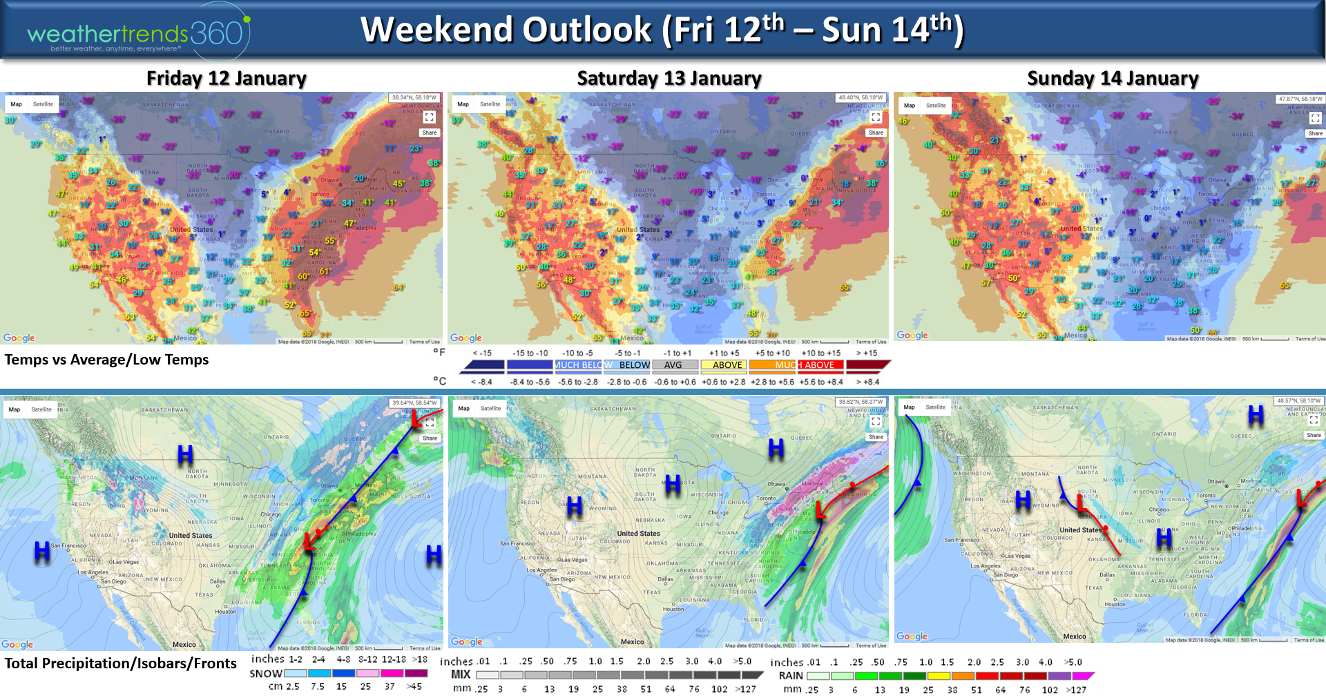
Another major Arctic outbreak headed for the Eastern half of the country. The cold front will sweep off the East Coast by Saturday but not before bringing widespread heavy rain ahead of the cold front and moderate snow on the back side of the front for the Ohio Valley and interior Northeast. CLICK ON IMAGES FOR LARGER VIEW.
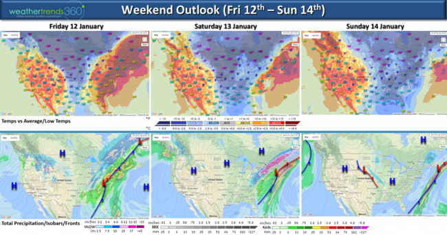
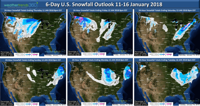
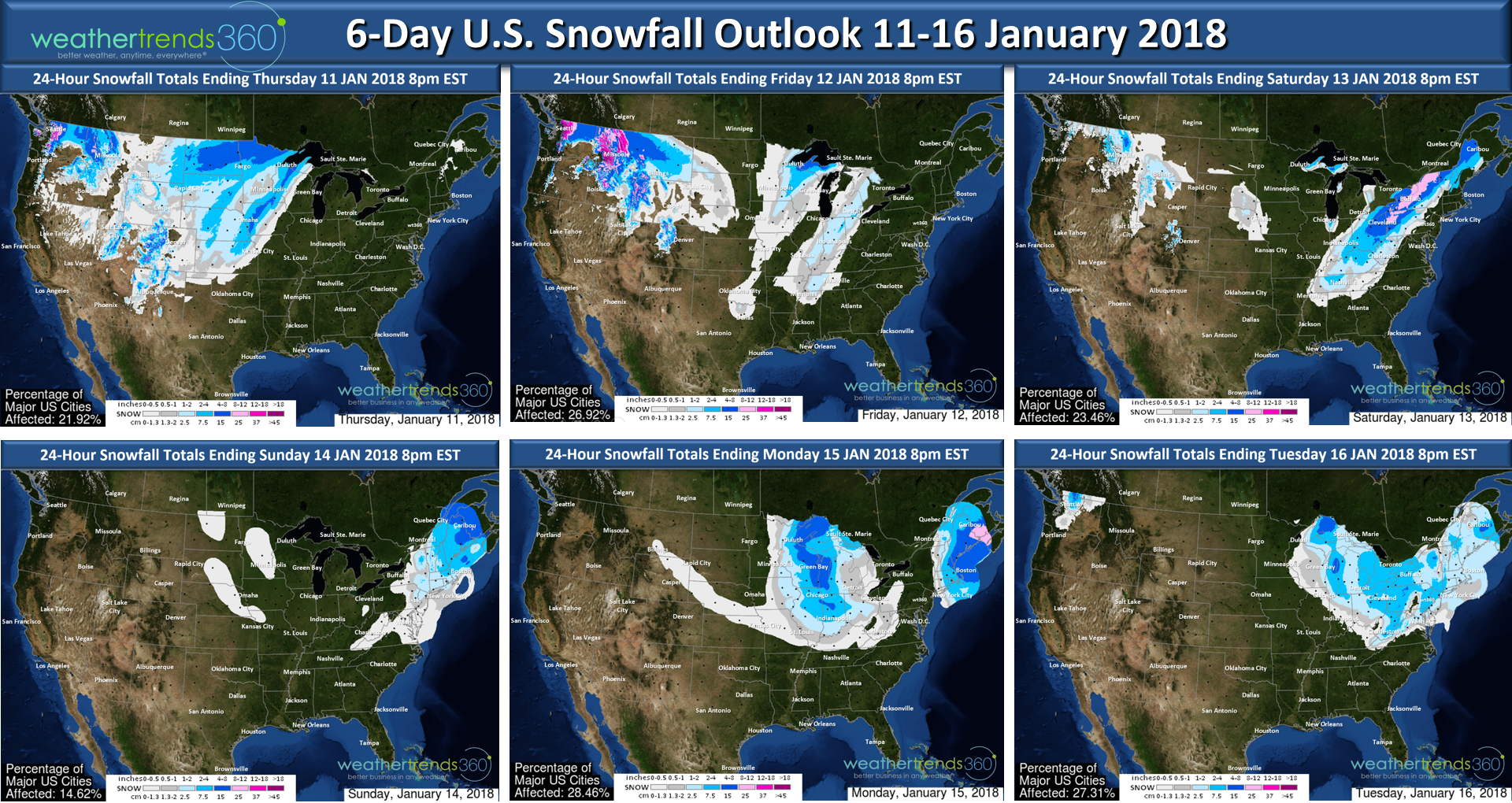
There is risk for some flooding due to the heavy rain as the ground is frozen solid 12-24" deep in areas of the Midwest and Northeast. The 6-day snowfall outlook shows the heaviest snow will be Saturday fromOhio to interior New England. Another fast moving Clipper system will move through the Midwest on MLK holiday and into the Northeast Monday and Tuesday with light to moderate snowfall.
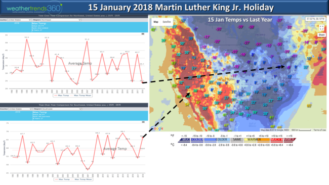
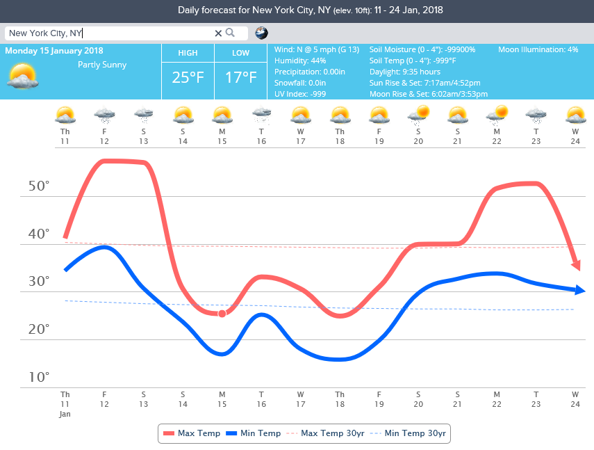
If you're lucky enough to be off on Monday for Martin Luther King Jr Holiday it will be frigid in the Northeast with the 2nd coldest MLK holiday in over 30 years, while the Southwest is the warm spot. This is a wholesale flip flop from last year when the SW was cold and the NE warm.
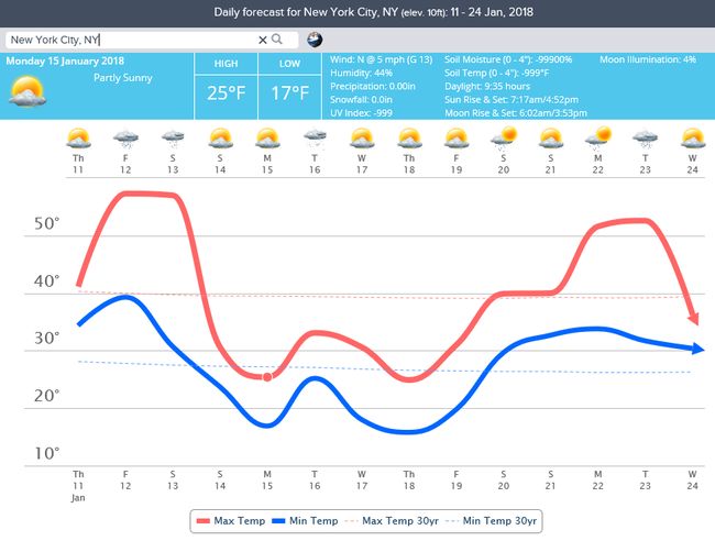
So for now enjoy the January Thaw in the East as we're headed for a week of much below normal temperatures next week. New York City roller coaster ride from warm to cold to warm back to cold is the general theme for the later half of January.
Have a great weekend.
Happy Monday (8 Jan 2018)! :)
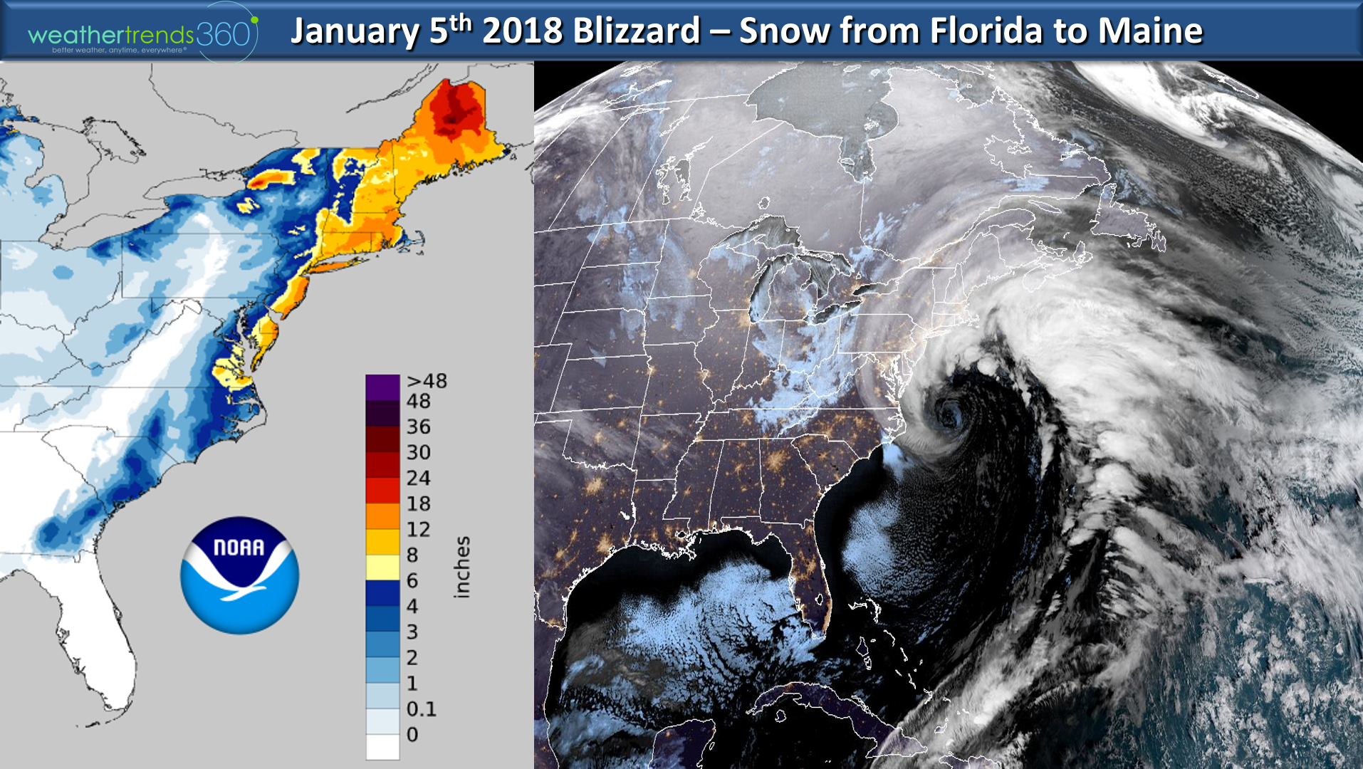
Who said it would be a cold/snowy winter in the Northeast months ago? :) wt360! The blizzard of 2018 wasn't a massive snow storm in terms of really heavy snow amounts, but it was a whopper on many other fronts with peaks winds of 122 mph on Mount Washington NH, 77 mph in VA and 76 mph for Cape Cod. Waves topped a near record at 56 feet off New England and the central pressure of this "bomb" Nor'easter was 27.95"...something rarely seen in a Winter storm and more typical of a major hurricane. A bomb cyclone simply means the storm intensifies 24 mb or more in 24 hours or less and this one intensified an estimated 60 mb in 24 hours (very possibly a record) so very deserving of the perceived media hype name but the rest of the hype not so much. Watch this hysterical video on "bomb cyclone".CLICK ON IMAGES FOR LARGER VIEW.

Peak snow totals by state: Holden, ME: 24.0", Sharon, MA: 19.0", Bayville, NJ: 18.0", Hancock, NH: 17.9", Warren, RI: 16.9", Staffordville, CT: 16.6", Terryville, NY: 16.4",Hallwood, VA: 14.8",Morgan, VT: 14.0", Pittsville, MD: 13.0", Rockyhock, NC: 12.0", Stockley, DE: 11.4", Andrews, SC: 8.0", Ellabell, GA: 6.0", Killearn Lakes, FL: 0.1"
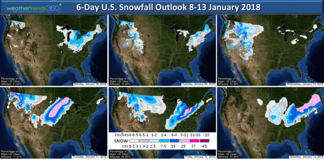
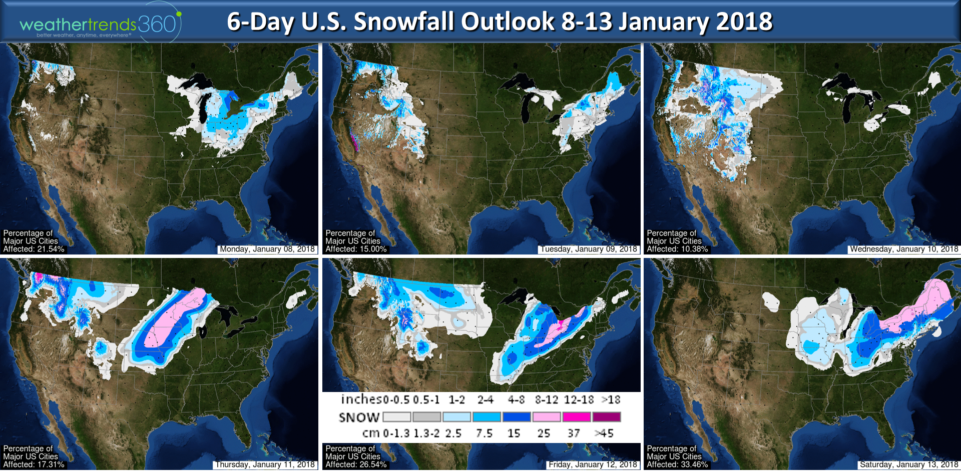
Snowfall over the next 6 days will bring lighter snow to the Northeast with the bigger threats shifting to the Central U.S.
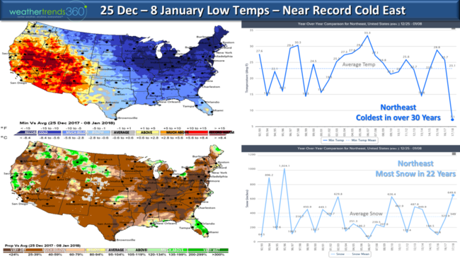
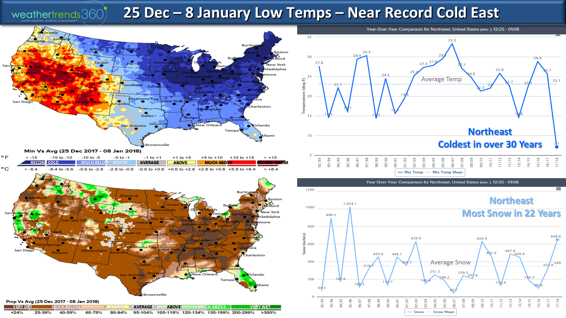
Temperatures since Christmas have been near record cold in the East with the most snow in 22 years over the 2-week period. Here at wt360 we have been below freezing for over 2 weeks. The West has been the warm spot. It's interesting to note that overall precipitation was much below normal even in areas that had heavy snowfall...you don't need much precip with very cold temperatures to make above average snowfall.
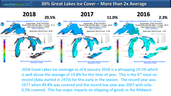
The ice cover on the Great Lakes is also off to a very fast start trending more than twice average and exponentially more than the past couple Winters. 29.5% of the lakes are already covered and Lake Erie is almost completely covered in ice. The plus to more ice is it tends to cut down big lake effect snow storms so Erie PA that had an epic record shattering snowy December should be out of the woods for the rest of Winter. The peak snow cover year was 1977 when 49.8% of the lakes had ice and the low year was 2007 when only 0.3% was covered. This much ice is very disruptive to shipping on the lakes.
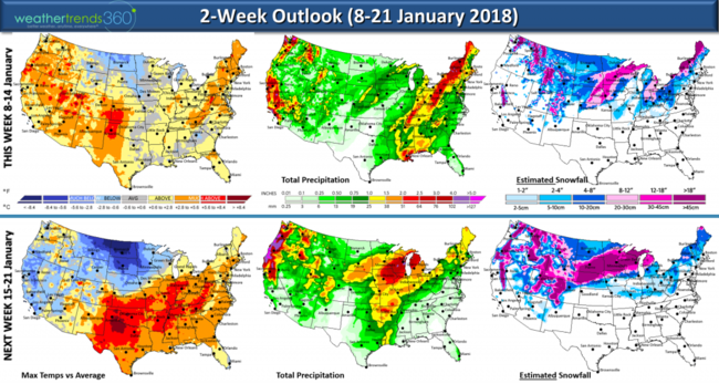
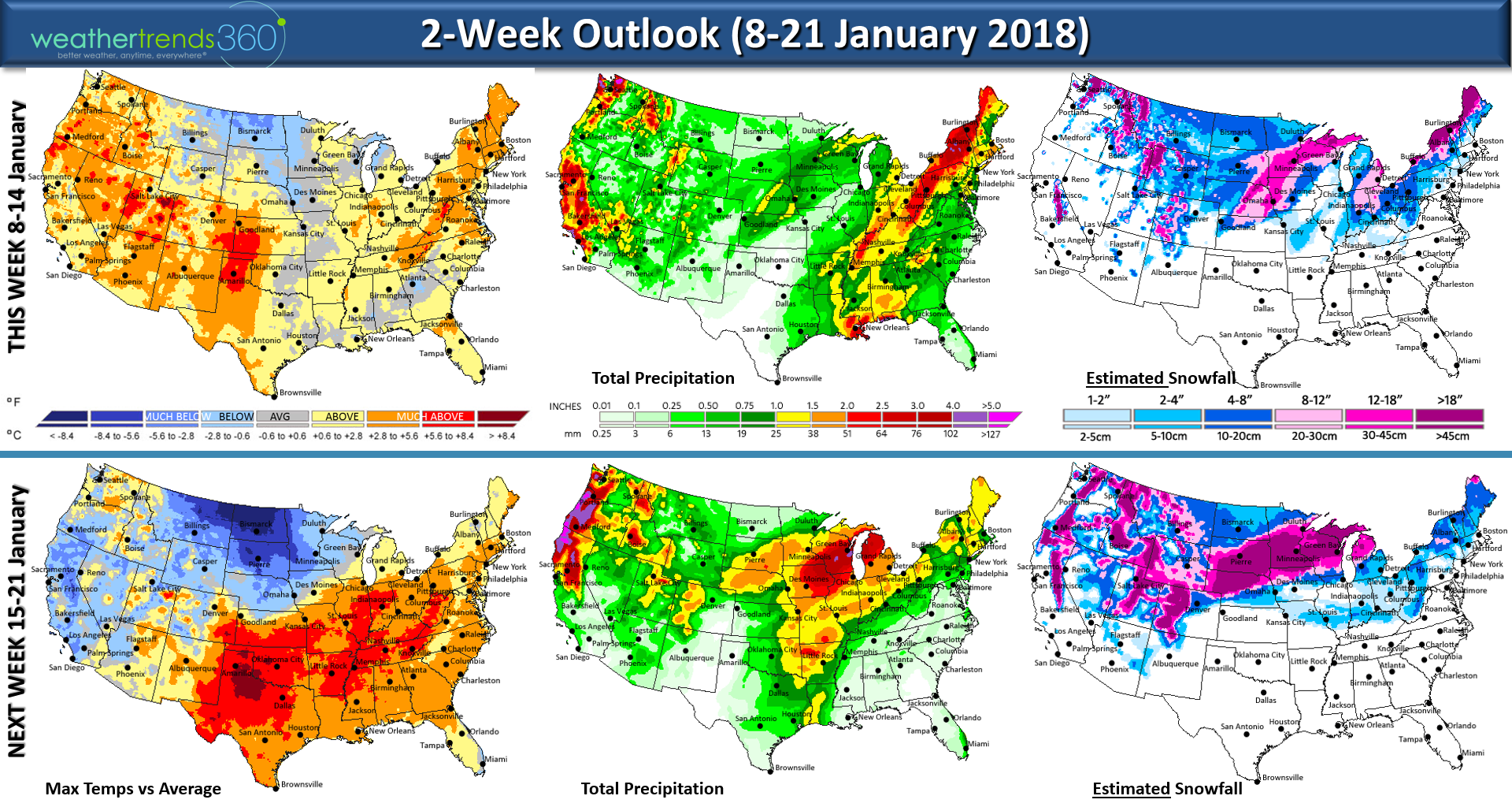
The 2-week outlook shows a much needed January thaw but as the Arctic air retreats there is a greater risk for heavier wet snow storms, especially in the Midwest over the next couple weeks. Yes California finally gets some rain too with heavy Rocky Mountain snowfall! The pattern will likely flip back to cold/snowy in the East in late January into February so Winter is not over!!!
wt360 was mentioned in BuzzFeed on how this extreme cold is helping or hurting businesses.
Follow us on Facebook and Twitter for daily updates.
Have a great week! - Captain Kirk out.
Another major Arctic outbreak headed for the Eastern half of the country. The cold front will sweep off the East Coast by Saturday but not before bringing widespread heavy rain ahead of the cold front and moderate snow on the back side of the front for the Ohio Valley and interior Northeast. CLICK ON IMAGES FOR LARGER VIEW.
There is risk for some flooding due to the heavy rain as the ground is frozen solid 12-24" deep in areas of the Midwest and Northeast. The 6-day snowfall outlook shows the heaviest snow will be Saturday fromOhio to interior New England. Another fast moving Clipper system will move through the Midwest on MLK holiday and into the Northeast Monday and Tuesday with light to moderate snowfall.
If you're lucky enough to be off on Monday for Martin Luther King Jr Holiday it will be frigid in the Northeast with the 2nd coldest MLK holiday in over 30 years, while the Southwest is the warm spot. This is a wholesale flip flop from last year when the SW was cold and the NE warm.

So for now enjoy the January Thaw in the East as we're headed for a week of much below normal temperatures next week. New York City roller coaster ride from warm to cold to warm back to cold is the general theme for the later half of January.
Have a great weekend.
Happy Monday (8 Jan 2018)! :)
Who said it would be a cold/snowy winter in the Northeast months ago? :) wt360! The blizzard of 2018 wasn't a massive snow storm in terms of really heavy snow amounts, but it was a whopper on many other fronts with peaks winds of 122 mph on Mount Washington NH, 77 mph in VA and 76 mph for Cape Cod. Waves topped a near record at 56 feet off New England and the central pressure of this "bomb" Nor'easter was 27.95"...something rarely seen in a Winter storm and more typical of a major hurricane. A bomb cyclone simply means the storm intensifies 24 mb or more in 24 hours or less and this one intensified an estimated 60 mb in 24 hours (very possibly a record) so very deserving of the perceived media hype name but the rest of the hype not so much. Watch this hysterical video on "bomb cyclone".CLICK ON IMAGES FOR LARGER VIEW.
Peak snow totals by state: Holden, ME: 24.0", Sharon, MA: 19.0", Bayville, NJ: 18.0", Hancock, NH: 17.9", Warren, RI: 16.9", Staffordville, CT: 16.6", Terryville, NY: 16.4",Hallwood, VA: 14.8",Morgan, VT: 14.0", Pittsville, MD: 13.0", Rockyhock, NC: 12.0", Stockley, DE: 11.4", Andrews, SC: 8.0", Ellabell, GA: 6.0", Killearn Lakes, FL: 0.1"
Snowfall over the next 6 days will bring lighter snow to the Northeast with the bigger threats shifting to the Central U.S.
Temperatures since Christmas have been near record cold in the East with the most snow in 22 years over the 2-week period. Here at wt360 we have been below freezing for over 2 weeks. The West has been the warm spot. It's interesting to note that overall precipitation was much below normal even in areas that had heavy snowfall...you don't need much precip with very cold temperatures to make above average snowfall.
The ice cover on the Great Lakes is also off to a very fast start trending more than twice average and exponentially more than the past couple Winters. 29.5% of the lakes are already covered and Lake Erie is almost completely covered in ice. The plus to more ice is it tends to cut down big lake effect snow storms so Erie PA that had an epic record shattering snowy December should be out of the woods for the rest of Winter. The peak snow cover year was 1977 when 49.8% of the lakes had ice and the low year was 2007 when only 0.3% was covered. This much ice is very disruptive to shipping on the lakes.

The 2-week outlook shows a much needed January thaw but as the Arctic air retreats there is a greater risk for heavier wet snow storms, especially in the Midwest over the next couple weeks. Yes California finally gets some rain too with heavy Rocky Mountain snowfall! The pattern will likely flip back to cold/snowy in the East in late January into February so Winter is not over!!!
wt360 was mentioned in BuzzFeed on how this extreme cold is helping or hurting businesses.
Follow us on Facebook and Twitter for daily updates.
Have a great week! - Captain Kirk out.