Star Date 11 July 2017 Tuesday
Captain's Log
Happy Tuesday!
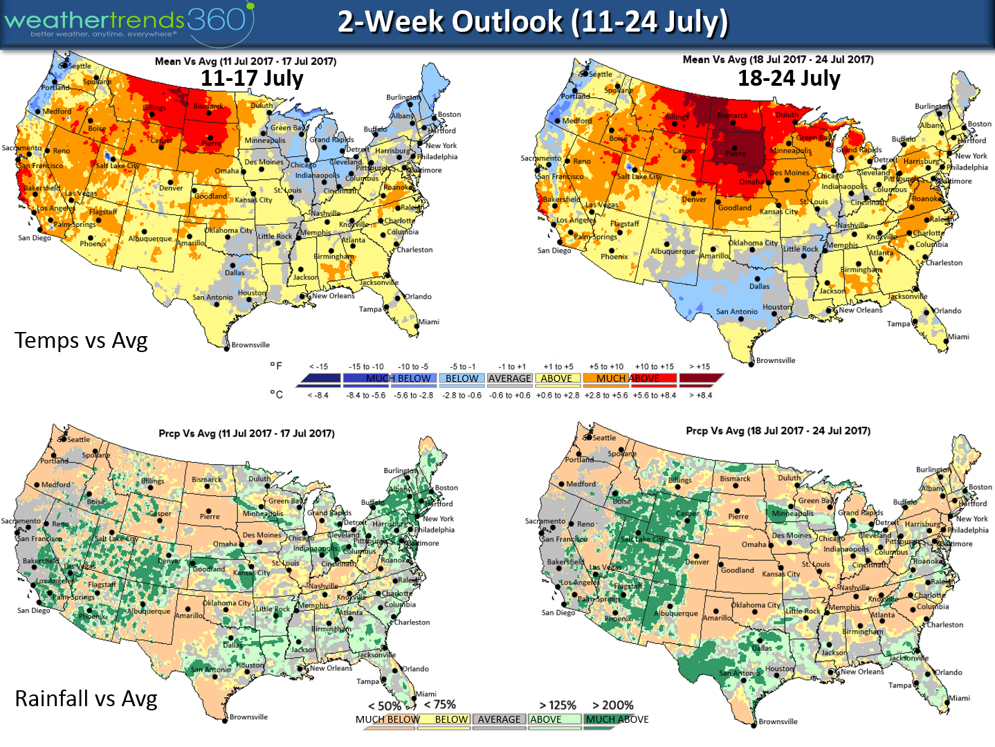
Take the short range computer model week 2 forecasts with a grain of salt as both the Euro and US GFS models have been performing very poorly in the week 2 time frame. And now both are polar opposite for the 10-14 day pattern with the Euro much colder in the East with an MJO pulse going from phase 3 to 4 (hot to cold pattern) while the GFS goes from phase 3 to nothing (remains hotter in week 2). Persistence says it will remain hot/dry where it's been hot dry (Plains, Central U.S.) while the East is more up and down warm and cool periods but remaining wet. Wet areas tend to remain cooler/wet while drier areas tend to remain hot/dry - typical in Summer. CLICK ON MAPS FOR LARGER VIEW.
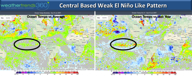
 The other factor playing a role this Summer is a weak central El Nino like pattern that typically brings very wet conditions to the East which certainly has been the case this Spring-Summer. This pattern plus a dry pattern in the Indian Ocean in part is helping to keep the Atlantic basin hurricane activitylow.
The year-over-year changes are pretty amazing here at wt360 headquarters (Bethlehem, PA) going from one of the driest Spring-Summers on record last year to the 2nd wettest in decades this year. Polar opposite out in the Central U.S. where they went from extremely wet last year in the Plains/N. Rocky Mountains to bone dry this year, especially up in the Dakotas and Montana. Both regions are experiencing the greatest year-over-year change in rainfall on record.

Across the world other big changes include much drier conditions in India, Central Australia and Eastern China while it's much wetter in Argentina and much of South America, U.S. East Coast, Northern Africa and Eastern Australia.
We hope you have a great week! Hard to believe its middle July already.
- Captain Kirk out.
Take the short range computer model week 2 forecasts with a grain of salt as both the Euro and US GFS models have been performing very poorly in the week 2 time frame. And now both are polar opposite for the 10-14 day pattern with the Euro much colder in the East with an MJO pulse going from phase 3 to 4 (hot to cold pattern) while the GFS goes from phase 3 to nothing (remains hotter in week 2). Persistence says it will remain hot/dry where it's been hot dry (Plains, Central U.S.) while the East is more up and down warm and cool periods but remaining wet. Wet areas tend to remain cooler/wet while drier areas tend to remain hot/dry - typical in Summer. CLICK ON MAPS FOR LARGER VIEW.
 The other factor playing a role this Summer is a weak central El Nino like pattern that typically brings very wet conditions to the East which certainly has been the case this Spring-Summer. This pattern plus a dry pattern in the Indian Ocean in part is helping to keep the Atlantic basin hurricane activitylow.
The year-over-year changes are pretty amazing here at wt360 headquarters (Bethlehem, PA) going from one of the driest Spring-Summers on record last year to the 2nd wettest in decades this year. Polar opposite out in the Central U.S. where they went from extremely wet last year in the Plains/N. Rocky Mountains to bone dry this year, especially up in the Dakotas and Montana. Both regions are experiencing the greatest year-over-year change in rainfall on record.
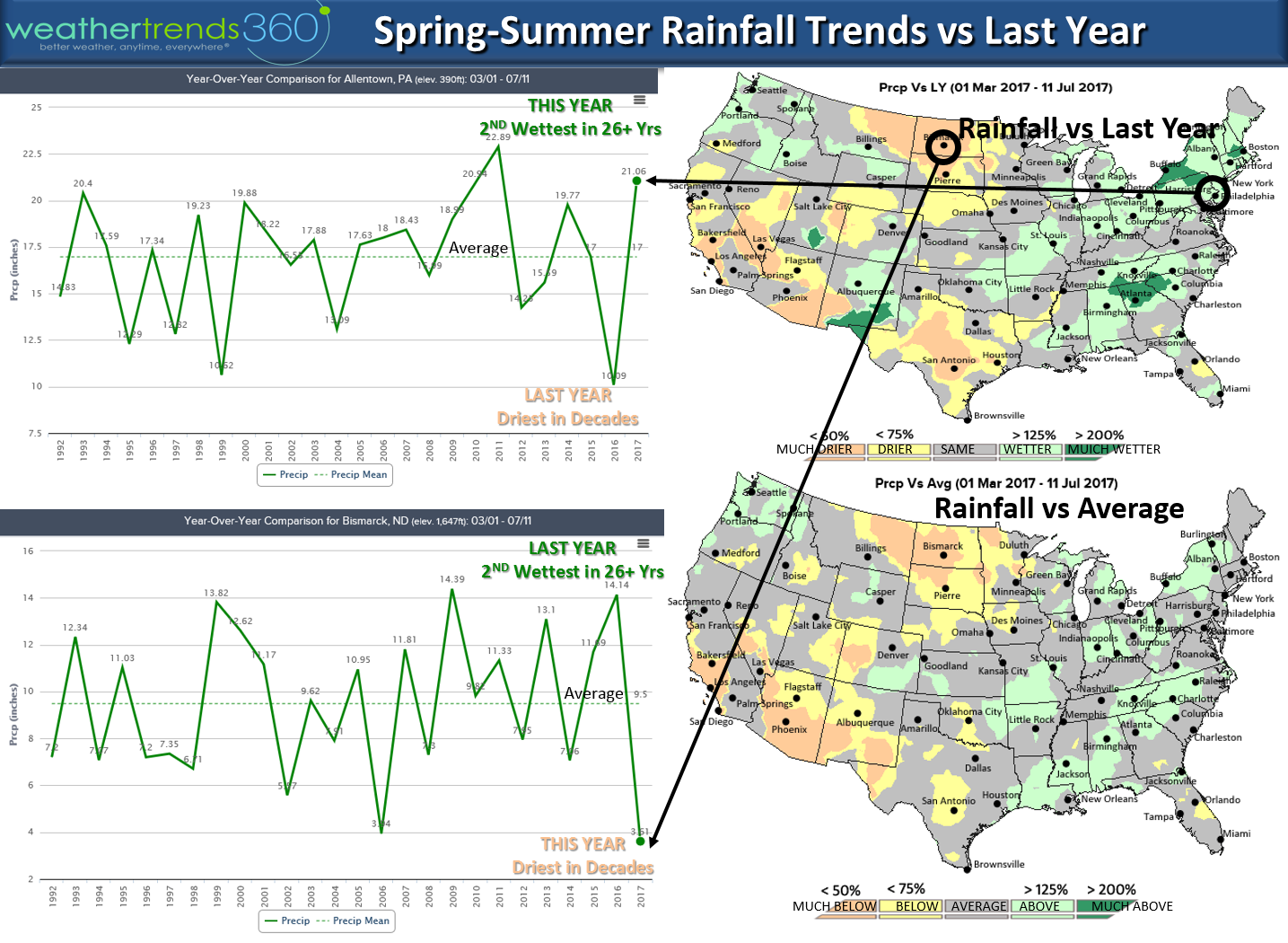
Across the world other big changes include much drier conditions in India, Central Australia and Eastern China while it's much wetter in Argentina and much of South America, U.S. East Coast, Northern Africa and Eastern Australia.
We hope you have a great week! Hard to believe its middle July already.
- Captain Kirk out.