Star Date: 12 September 2016 Monday
Captain's Log
Hard to believe it's middle September already.
LAST WEEK (5-11 SEPT): the highlights were Tropical Storm Hermine meandering off the Northeast ruining Labor Day for shore communities despite the storm never making land fall. National temperatures were 3rd warmest of the past 25 years but a tad cooler than last year. Rainfall was 7th driest of the past 25 years and driest in 3 years for the nation as a whole.
THIS WEEK (12-18 SEPT): It cooled off briefly in the Central U.S. and East Coast Sunday but that refreshing Fall like air will be short lived. Overall the week trends 9th warmest of the past 25 years and warmest in 7 years for the U.S. as a whole. Rainfall is the wettest in 4 years trending 7th wettest of the past 25 years. It's winter like in the low elevations of Montana and Wyoming this week with snow down to about 3,000 feet early this week but then back to 70s next weekend so it's short lived.
Tropical Storm Ian has formed in the Atlantic but the system will remain a fish storm not impacting land as it heads up into the North Central Atlantic. A weak systems in the Bahamas probably won't get a name as it brings heavier rain to Florida. On the other side of the World we have super typhoon Meranti (winds 132mph gusts to 161) headed for Southern Taiwan (again) by late Tuesday early Wednesday before drenching already soggy Eastern China later this week. Tropical Storm 18 has already formed with a similar track but appears to veer north toward Southern Japan this weekend.
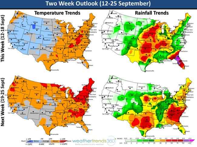
NEXT WEEK (19-25 SEPT): National temperatures show a warming trend with the week overall the 4th warmest of the past 25 years even though a tad cooler than last year. Rainfall is 5th wettest in 25 years and wettest in 3 years for the U.S. overall. Autumn according to the Sun arrives Thursday 22 September at 10:21am EDT but it will feel like the heart of Summer in the Northeast and Northwest with the only cooler than average spots in the Central Plains. There's another tropical threat for the Southwest U.S. late in the week with the potential for some flooding in the deserts - way out there but something to watch. There's also looks to be a lot of thunderstorm activity coming off Sub Sahara Africa so the tropics will bear watching as we're in the peak of the Atlantic Hurricane Season.
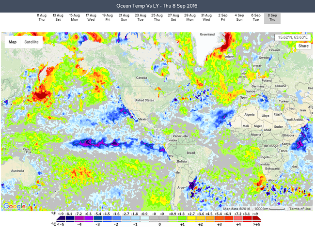
La Niña Update: While still weak from an absolute index perspective, the Central based La Niñaremains 1 of 24 climate indices we track that favor a cold Winter from the Northern Rockies to Midwest into the Northeast with frequent Alberta Clipper type snow events. We have a prolonged cold winter from December to April with more late Spring freezes in 2017. Ocean temperatures around the world a dramatically different than last year when an epic El Niño was developing. Doesn't bode well for California with a drier Winter.
Have a great week folks! - Capt Kirk out.
LAST WEEK (5-11 SEPT): the highlights were Tropical Storm Hermine meandering off the Northeast ruining Labor Day for shore communities despite the storm never making land fall. National temperatures were 3rd warmest of the past 25 years but a tad cooler than last year. Rainfall was 7th driest of the past 25 years and driest in 3 years for the nation as a whole.
THIS WEEK (12-18 SEPT): It cooled off briefly in the Central U.S. and East Coast Sunday but that refreshing Fall like air will be short lived. Overall the week trends 9th warmest of the past 25 years and warmest in 7 years for the U.S. as a whole. Rainfall is the wettest in 4 years trending 7th wettest of the past 25 years. It's winter like in the low elevations of Montana and Wyoming this week with snow down to about 3,000 feet early this week but then back to 70s next weekend so it's short lived.
Tropical Storm Ian has formed in the Atlantic but the system will remain a fish storm not impacting land as it heads up into the North Central Atlantic. A weak systems in the Bahamas probably won't get a name as it brings heavier rain to Florida. On the other side of the World we have super typhoon Meranti (winds 132mph gusts to 161) headed for Southern Taiwan (again) by late Tuesday early Wednesday before drenching already soggy Eastern China later this week. Tropical Storm 18 has already formed with a similar track but appears to veer north toward Southern Japan this weekend.

NEXT WEEK (19-25 SEPT): National temperatures show a warming trend with the week overall the 4th warmest of the past 25 years even though a tad cooler than last year. Rainfall is 5th wettest in 25 years and wettest in 3 years for the U.S. overall. Autumn according to the Sun arrives Thursday 22 September at 10:21am EDT but it will feel like the heart of Summer in the Northeast and Northwest with the only cooler than average spots in the Central Plains. There's another tropical threat for the Southwest U.S. late in the week with the potential for some flooding in the deserts - way out there but something to watch. There's also looks to be a lot of thunderstorm activity coming off Sub Sahara Africa so the tropics will bear watching as we're in the peak of the Atlantic Hurricane Season.
La Niña Update: While still weak from an absolute index perspective, the Central based La Niñaremains 1 of 24 climate indices we track that favor a cold Winter from the Northern Rockies to Midwest into the Northeast with frequent Alberta Clipper type snow events. We have a prolonged cold winter from December to April with more late Spring freezes in 2017. Ocean temperatures around the world a dramatically different than last year when an epic El Niño was developing. Doesn't bode well for California with a drier Winter.
Have a great week folks! - Capt Kirk out.