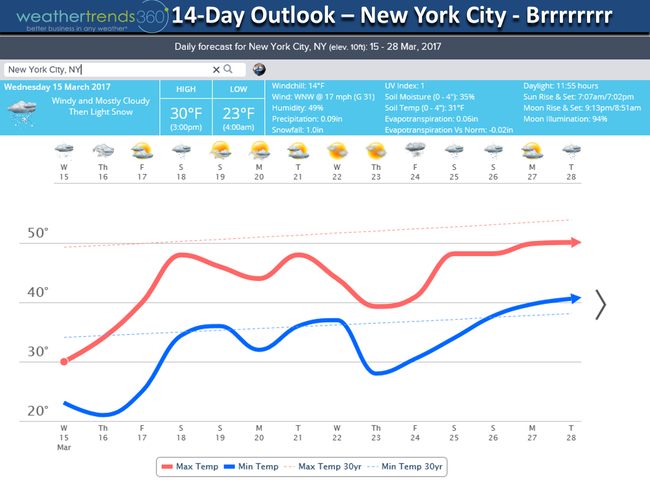
Star Date 15 March 2017 Wednesday
Captain's Log
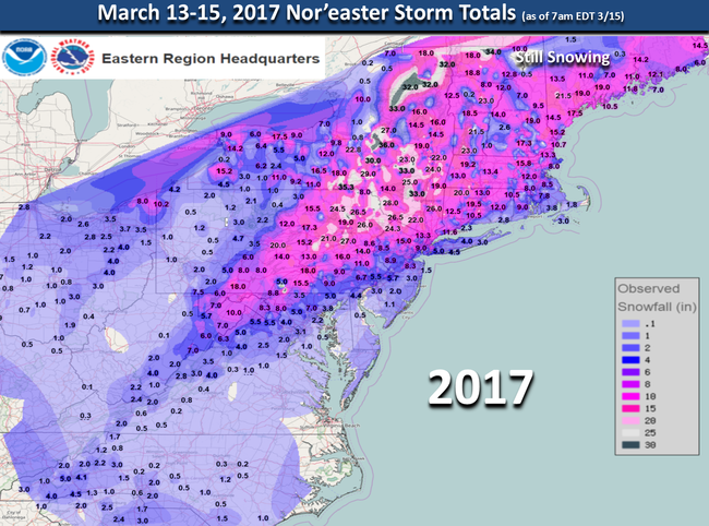
Nor'easter recap.
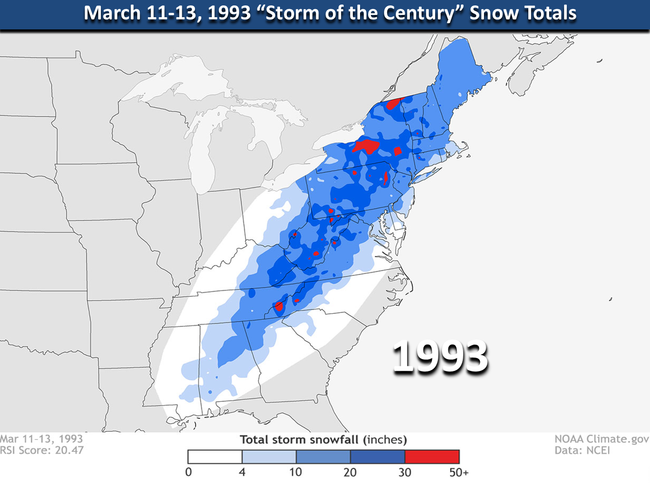
While some folks along the immediate coast are disappointed with the storm, millions got a big snow storm by March standards and for many it was even bigger than the "Storm of the Century" almost 24 years ago to the day.
Snow totals were actually greater with this storm than the 1993 blizzard for areas in the Poconos and interior New England. CLICK ON MAP FOR LARGER VIEW
While there were certainly a lot of similarities to the 1993 storm, the big difference is when the storm actually exploded (aka rapid development) or "bombed" off the coast. The 1993 storm "bombed" off the Georgia coast whereas the 2017 storm didn't until it got off Long Island. Both storms took a nearly identical track. This storm was closer to the coastline than the two main models (US GFS, EURO) indicated even as late as Monday when both increased snow expectations but both did well indicating this storm would happen almost 7 days out. The models also did well back in 1993 as it was the first time the models predicted a major event 5-days out which was a milestone some 24 years ago.
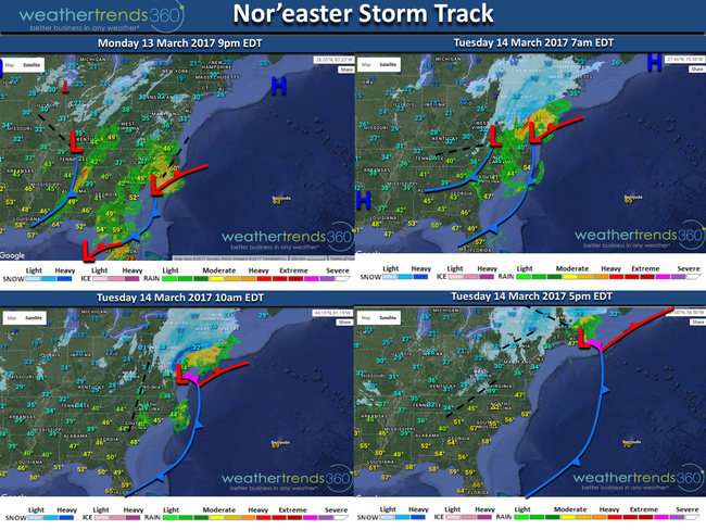
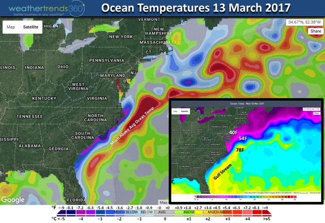
In light of how warm the Gulf Stream was it was a bit unusual this storm took a bit longer to really crank up as Gulf Stream temperatures were a good +10F above average. It was clear on the 10am radar that the bands of heavy snow/sleet were expanding outward when it was near Atlantic City NJ and that allowed a shallow layer of warmer air aloft to push inland as far as wt360 headquarters in Eastern PA. Ideally we would have seen the snow bands contract toward the center of the storm indicating colder air aloft was pulling in. This happened too late to give the immediate coastal areas heavier snow.
But it's rare to see heavy snow along the immediate coast in March as the water temperatures are just a bit too warm with 40F temps along the coast but 78F in the Gulf Stream off the East Coast.
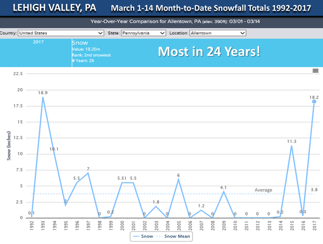
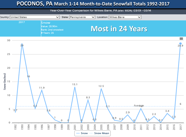
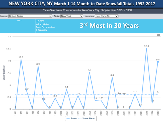
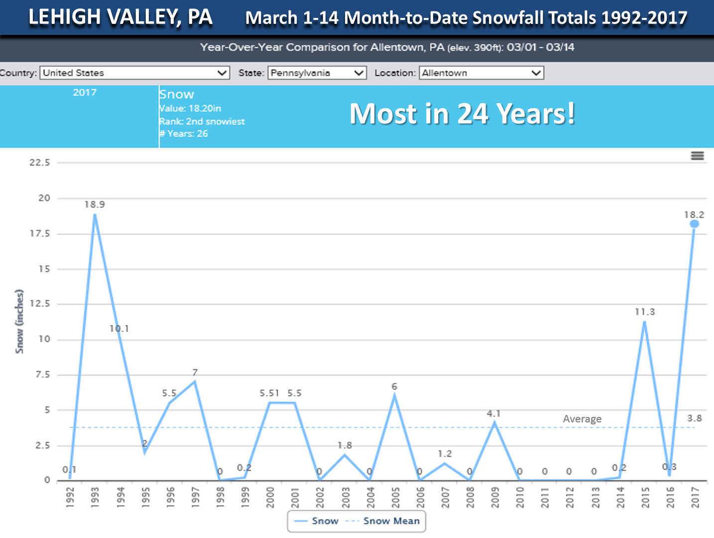
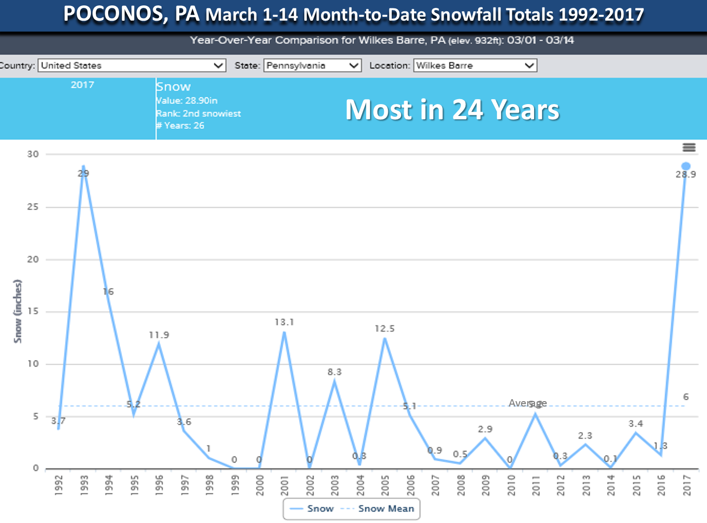
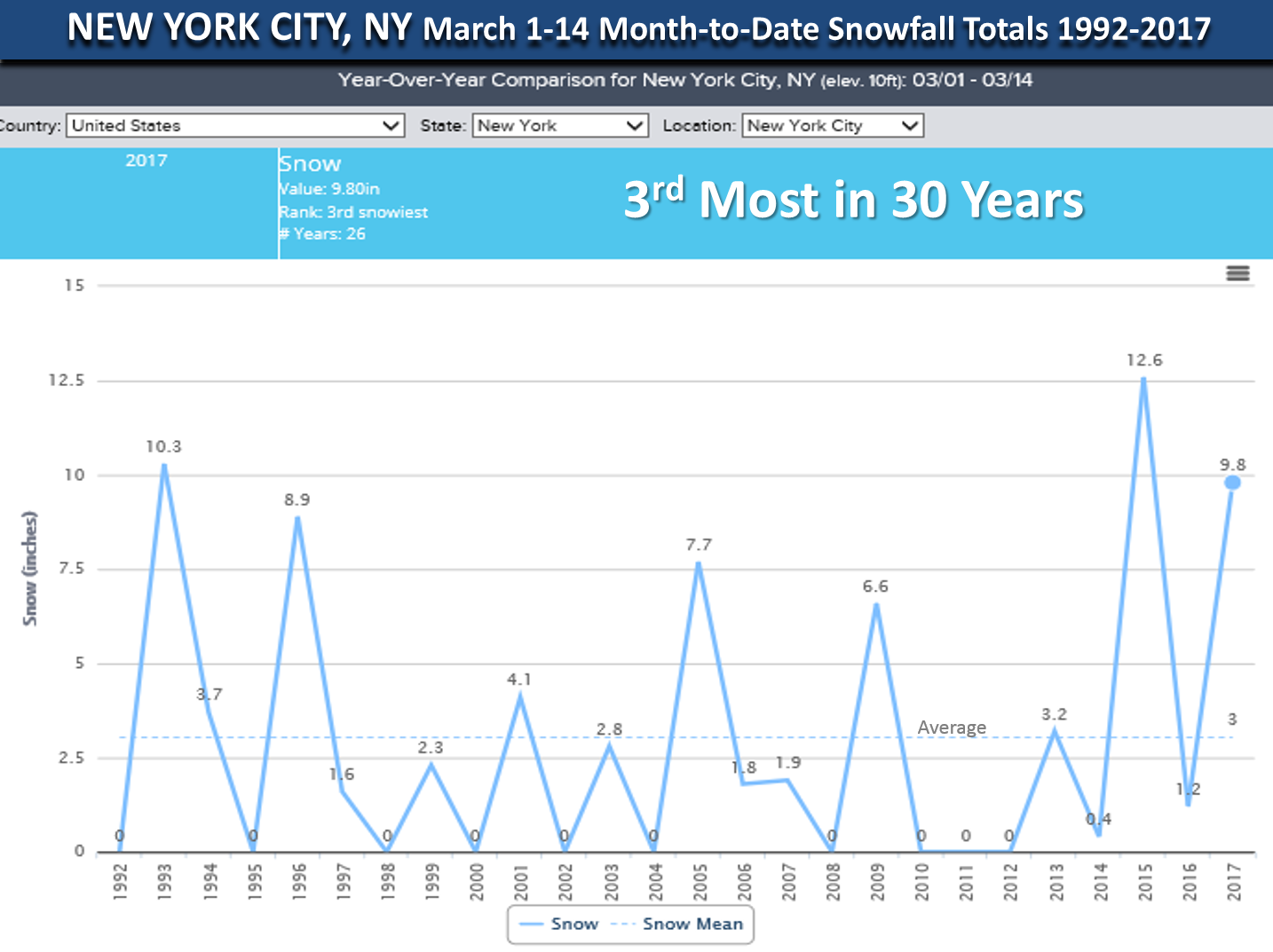
For the first 2-weeks of March many areas in the Northeast are off to a near record start in terms of snow totals and for many the most in 24 years. Select cities below. If we compare the 10-15 March period which captures the Storm of the Century period back in 1993 and this storm many areas actually have more snow this go around: Binghamton NY 32.5" this year vs 25.9" in 1993, Allentown PA 18.2" vs 18.0 in 1993, Poconos PA 28.9" vs 23.9", New York City 9.8" vs 9.7" in 1993, Newark NJ 9.7" vs 12.9" in 1993, Philadelphia less with 7" this year vs 12" in 1993, Washington D.C. 2.2" vs 6.6".
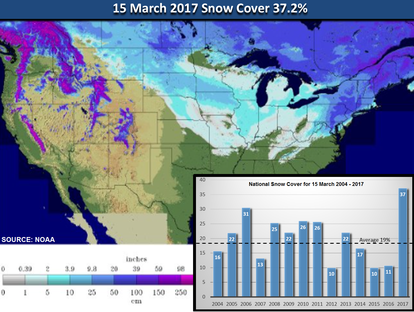
National snow cover for 15 March is near a record and the most since at least 1993. Last couple years were near record lows.

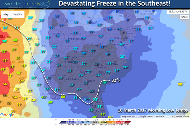
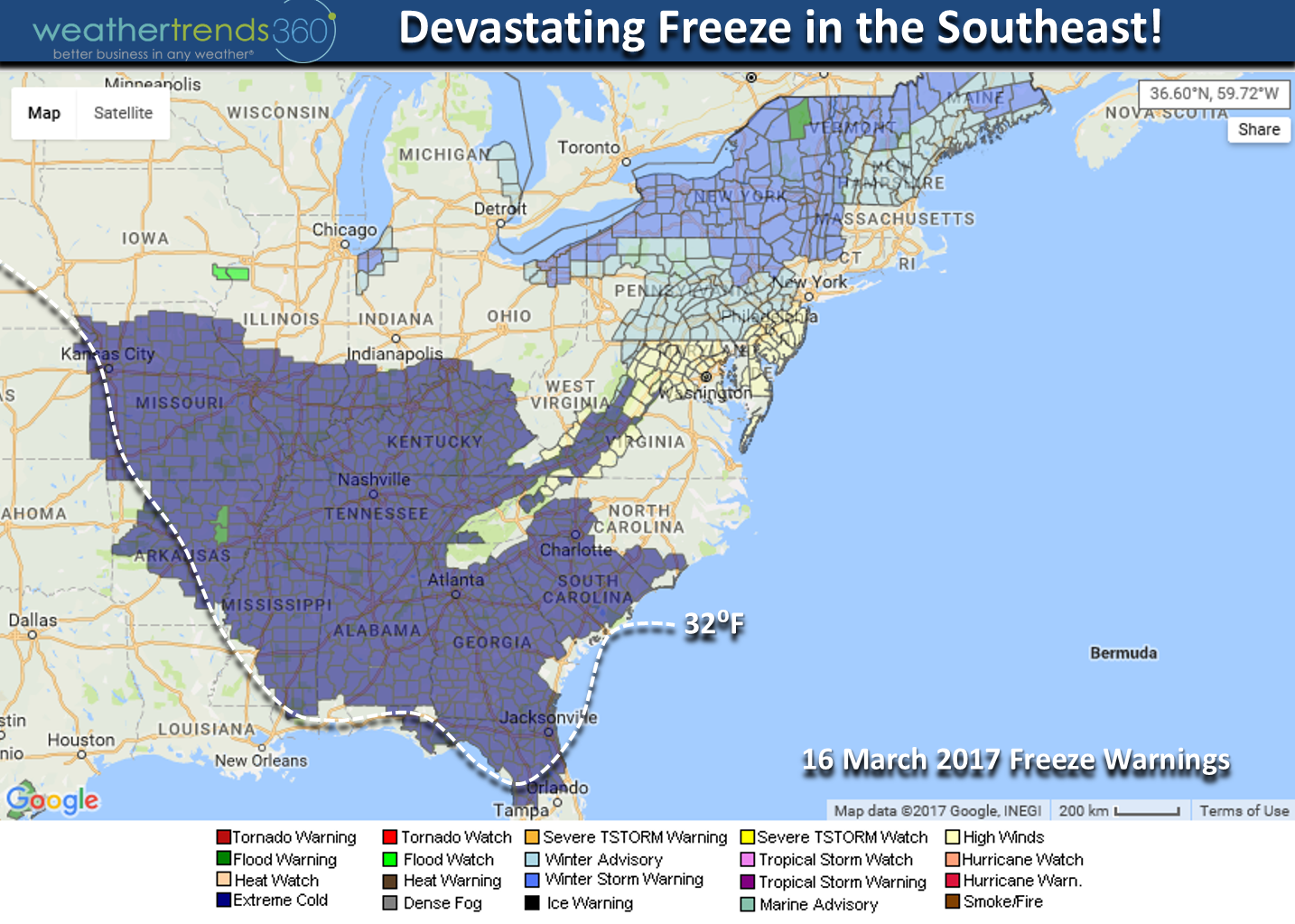
Now the big concern is a major devastating freeze all the way into North Florida tonight. With vegetation out a month early this will have a major impact on fruit crops, some early planted row crops and lawn and gardens. This also happened in 1993 only the vegetation wasn't as far along as it is this year.
 Don't look for above normal temperatures anytime soon in the Northeast as it remains cold for the balance of the month with more lighter snow threats! This middle March period is trending a whopping 20 to 40 degrees colder than last year! WTI was mentioned in the news on the big negative impact this is having on retailers.
Baby Angelina Kirk has certainly had some interesting weather in her first 14 months - the all-time blizzard last year (31.6") when she was born and now one of the biggest March blizzards on record. I think she's controlling the weather with a button on her little remote! :)

 Have a great Wednesday and dig out safe! This stuff was insanely heavy here in the Lehigh Valley of PA. Follow us on Facebook and Twitter for daily updates.
- Captain Kirk out.
While some folks along the immediate coast are disappointed with the storm, millions got a big snow storm by March standards and for many it was even bigger than the "Storm of the Century" almost 24 years ago to the day.
Snow totals were actually greater with this storm than the 1993 blizzard for areas in the Poconos and interior New England. CLICK ON MAP FOR LARGER VIEW

While there were certainly a lot of similarities to the 1993 storm, the big difference is when the storm actually exploded (aka rapid development) or "bombed" off the coast. The 1993 storm "bombed" off the Georgia coast whereas the 2017 storm didn't until it got off Long Island. Both storms took a nearly identical track. This storm was closer to the coastline than the two main models (US GFS, EURO) indicated even as late as Monday when both increased snow expectations but both did well indicating this storm would happen almost 7 days out. The models also did well back in 1993 as it was the first time the models predicted a major event 5-days out which was a milestone some 24 years ago.

In light of how warm the Gulf Stream was it was a bit unusual this storm took a bit longer to really crank up as Gulf Stream temperatures were a good +10F above average. It was clear on the 10am radar that the bands of heavy snow/sleet were expanding outward when it was near Atlantic City NJ and that allowed a shallow layer of warmer air aloft to push inland as far as wt360 headquarters in Eastern PA. Ideally we would have seen the snow bands contract toward the center of the storm indicating colder air aloft was pulling in. This happened too late to give the immediate coastal areas heavier snow.

But it's rare to see heavy snow along the immediate coast in March as the water temperatures are just a bit too warm with 40F temps along the coast but 78F in the Gulf Stream off the East Coast.

For the first 2-weeks of March many areas in the Northeast are off to a near record start in terms of snow totals and for many the most in 24 years. Select cities below. If we compare the 10-15 March period which captures the Storm of the Century period back in 1993 and this storm many areas actually have more snow this go around: Binghamton NY 32.5" this year vs 25.9" in 1993, Allentown PA 18.2" vs 18.0 in 1993, Poconos PA 28.9" vs 23.9", New York City 9.8" vs 9.7" in 1993, Newark NJ 9.7" vs 12.9" in 1993, Philadelphia less with 7" this year vs 12" in 1993, Washington D.C. 2.2" vs 6.6".
National snow cover for 15 March is near a record and the most since at least 1993. Last couple years were near record lows.
Now the big concern is a major devastating freeze all the way into North Florida tonight. With vegetation out a month early this will have a major impact on fruit crops, some early planted row crops and lawn and gardens. This also happened in 1993 only the vegetation wasn't as far along as it is this year.

 Don't look for above normal temperatures anytime soon in the Northeast as it remains cold for the balance of the month with more lighter snow threats! This middle March period is trending a whopping 20 to 40 degrees colder than last year! WTI was mentioned in the news on the big negative impact this is having on retailers.
Baby Angelina Kirk has certainly had some interesting weather in her first 14 months - the all-time blizzard last year (31.6") when she was born and now one of the biggest March blizzards on record. I think she's controlling the weather with a button on her little remote! :)

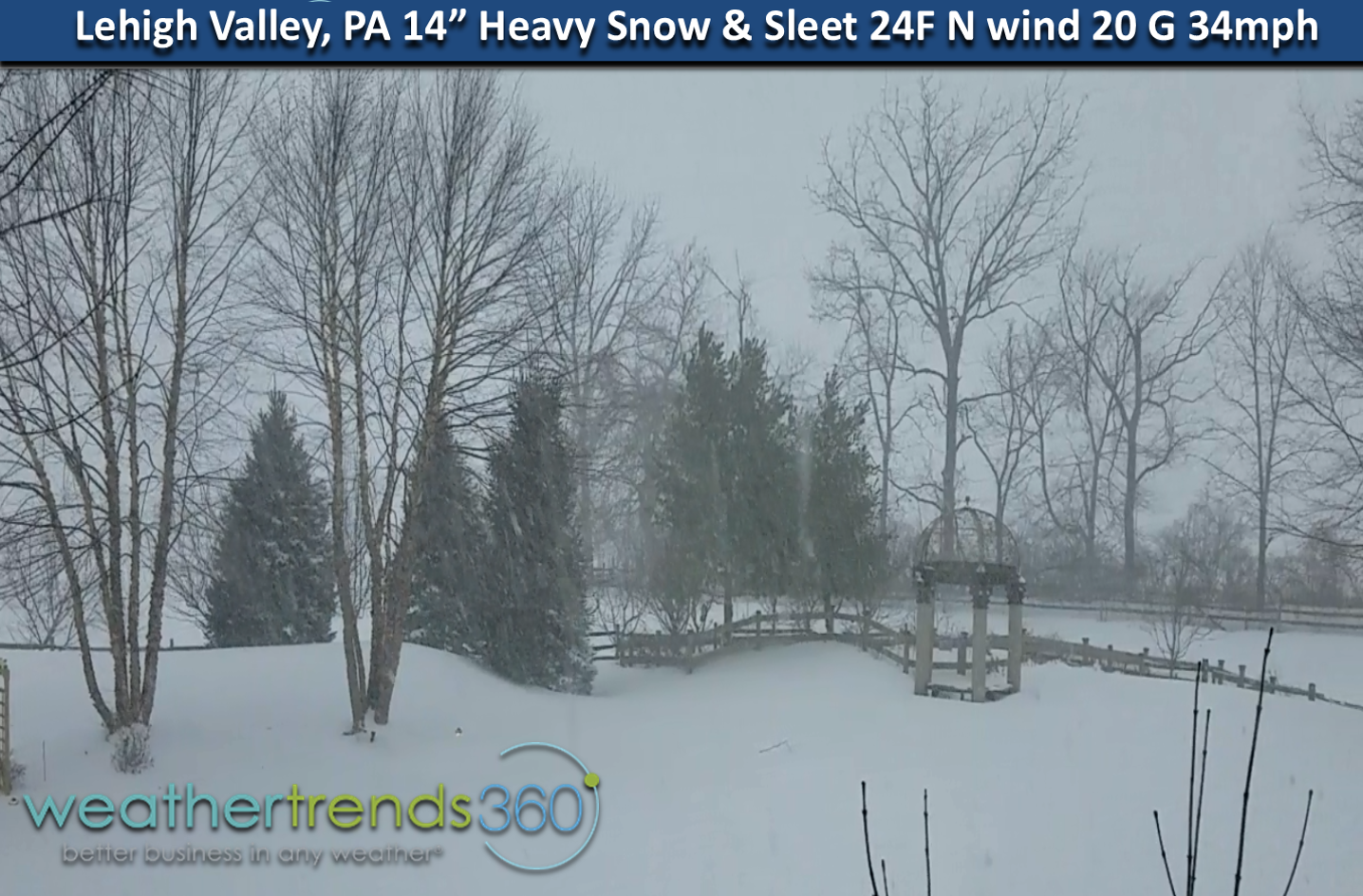 Have a great Wednesday and dig out safe! This stuff was insanely heavy here in the Lehigh Valley of PA. Follow us on Facebook and Twitter for daily updates.
- Captain Kirk out.