Star Date 16 January 2017 Monday (MLK Jr. Holiday)
Captain's Log
Happy Mondayon this Martin Luther King Jr. Holiday.
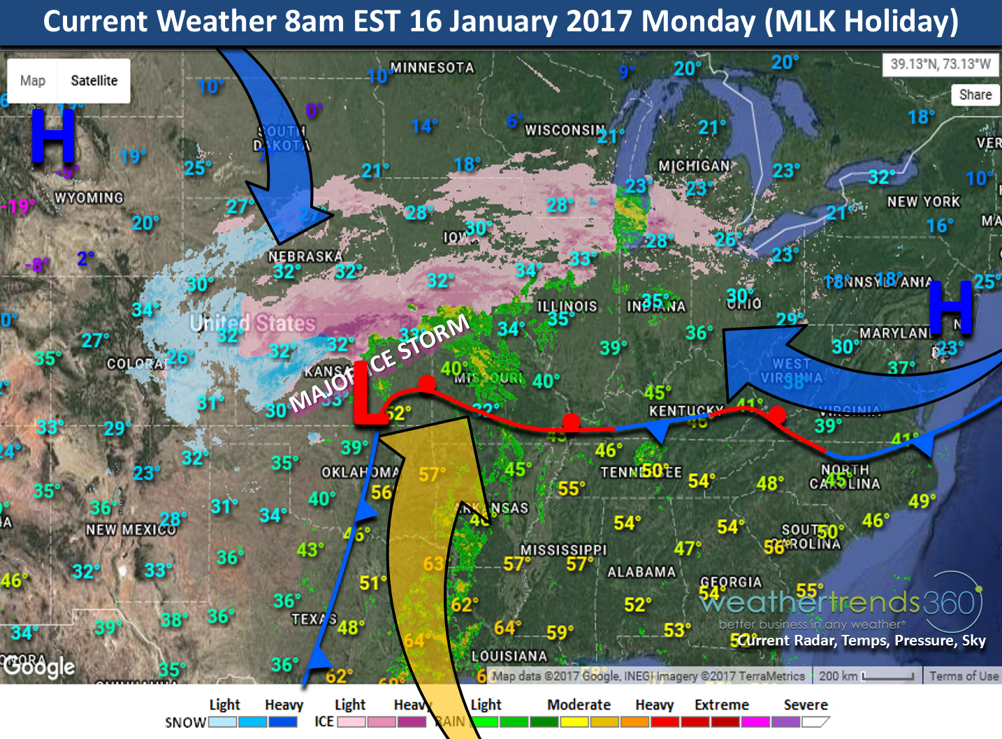
The big news this week is one of the worst ice storms since January 2009 to hit the Heartland of the U.S. Major ice accumulations will continue over the next 24hours and then this storm will finally move out. It's simply an over-running event where warm-moist air rides up and over a shallow layer of cold air at the surface thanks to two arctic high pressure systems funneling in cold air from the North and Northeast. The clash of air masses in Texas caused some tornadoes as well with one touching down in Dallas on Sunday.

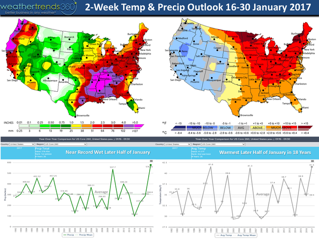
But, the pattern remains very active with 5 storms over the next two weeks traversing the U.S. making this later half of January near record wet for the U.S. overall. 2-week outlook has the west colder, wetter snowier while the East has a significant January thaw. The pattern does turn cooler late month in the East and early February. Middle February again likely to be warmer in the East and then very cold conditions later February into most of March for the Eastern half of the U.S.
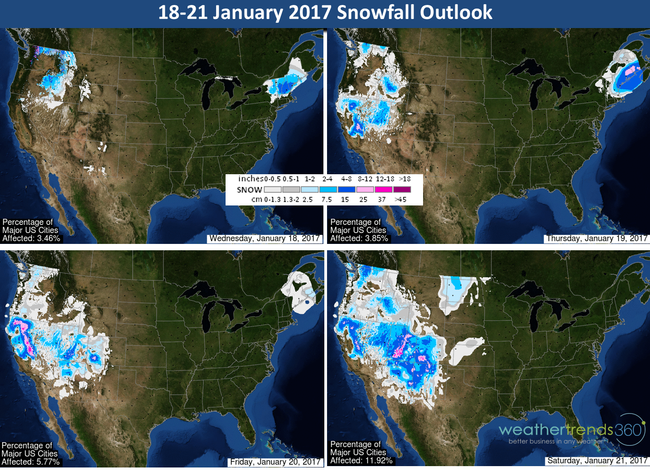
California better be ready for late Winter and Spring reservoir release flooding downstream as the North Central CA reservoirs will likely surpass capacity come April into June when the reservoirs reach peak capacity from snow melt. Yes we think the storm weather will continue into early Spring for California and the snow melt will be significant! Feet of snow again likely the 18th - 24th with a series of powerful storms pounding the West and California. 4-day snowfall outlook below shows feet of snow in the mountains of the West. Too much of a good thing has ski resorts closed with mountain passes impassable at times.
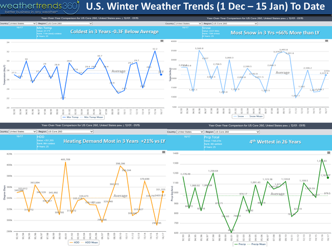
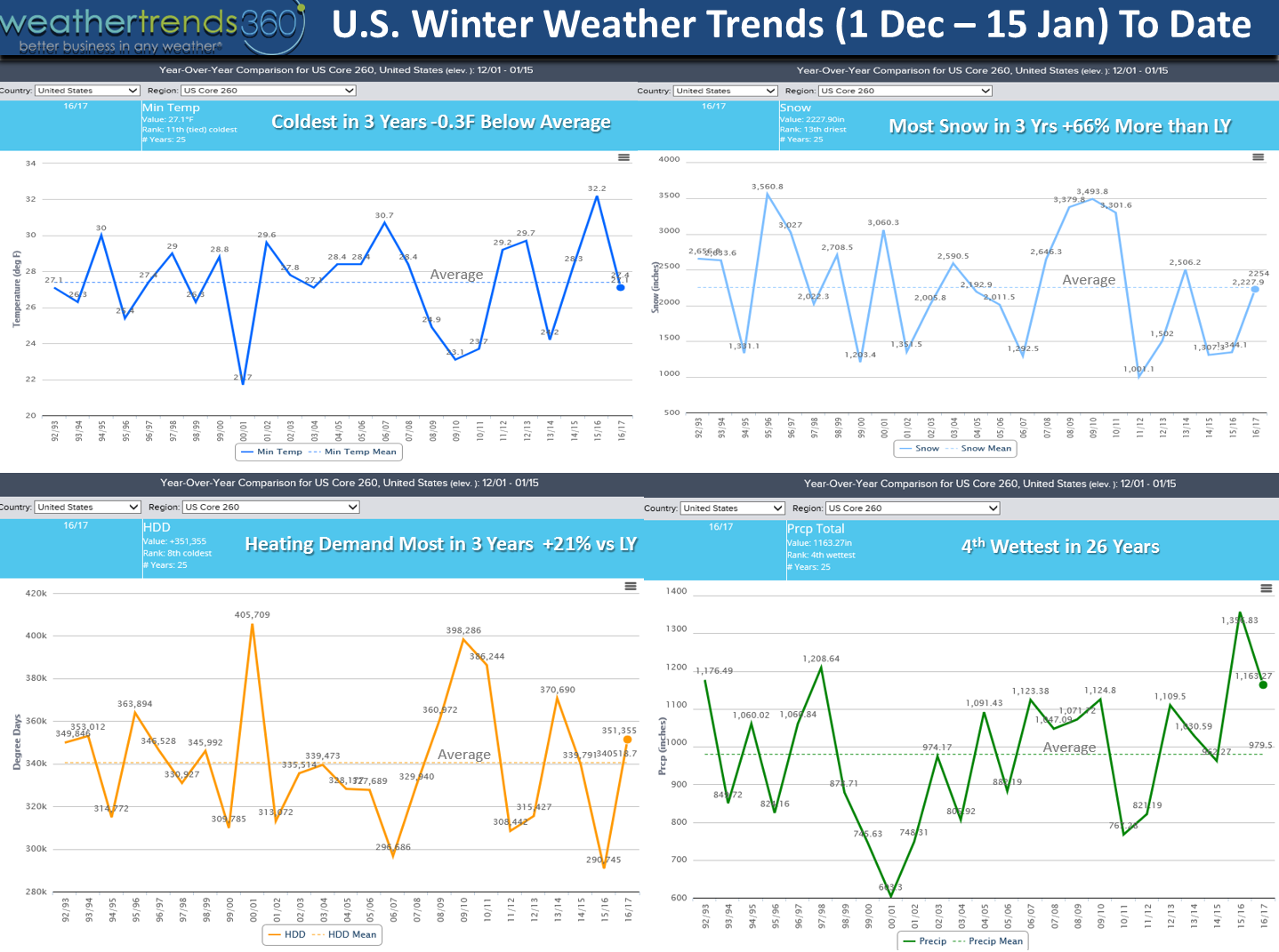
The first 45 days of meteorological Winter are done (1 Dec - 15 Jan) and it's average a tad cool for the U.S. as a whole. The extremes have been pretty amazing going from near record cold to near record warm but overall the U.S. to date is -0.3F below average for 260 major cities across the U.S., coolest in 3 years. National snowfall is near average and 66% more than last year. Rainfall is 4th wettest in 26 years but that is likely to go to number 1 wettest but the end of January. National heating demand is up 21% over last year so you're heating bills are going to be more expensive - especially when you get your December bill this month.
Follow us on Facebook and Twitter for daily updates! We're just a couple weeks away from making some big announcements on what we've been up to over the past few months and years for that matter.
- Captain Kirk out.
The big news this week is one of the worst ice storms since January 2009 to hit the Heartland of the U.S. Major ice accumulations will continue over the next 24hours and then this storm will finally move out. It's simply an over-running event where warm-moist air rides up and over a shallow layer of cold air at the surface thanks to two arctic high pressure systems funneling in cold air from the North and Northeast. The clash of air masses in Texas caused some tornadoes as well with one touching down in Dallas on Sunday.
But, the pattern remains very active with 5 storms over the next two weeks traversing the U.S. making this later half of January near record wet for the U.S. overall. 2-week outlook has the west colder, wetter snowier while the East has a significant January thaw. The pattern does turn cooler late month in the East and early February. Middle February again likely to be warmer in the East and then very cold conditions later February into most of March for the Eastern half of the U.S.

California better be ready for late Winter and Spring reservoir release flooding downstream as the North Central CA reservoirs will likely surpass capacity come April into June when the reservoirs reach peak capacity from snow melt. Yes we think the storm weather will continue into early Spring for California and the snow melt will be significant! Feet of snow again likely the 18th - 24th with a series of powerful storms pounding the West and California. 4-day snowfall outlook below shows feet of snow in the mountains of the West. Too much of a good thing has ski resorts closed with mountain passes impassable at times.

The first 45 days of meteorological Winter are done (1 Dec - 15 Jan) and it's average a tad cool for the U.S. as a whole. The extremes have been pretty amazing going from near record cold to near record warm but overall the U.S. to date is -0.3F below average for 260 major cities across the U.S., coolest in 3 years. National snowfall is near average and 66% more than last year. Rainfall is 4th wettest in 26 years but that is likely to go to number 1 wettest but the end of January. National heating demand is up 21% over last year so you're heating bills are going to be more expensive - especially when you get your December bill this month.
Follow us on Facebook and Twitter for daily updates! We're just a couple weeks away from making some big announcements on what we've been up to over the past few months and years for that matter.
- Captain Kirk out.