Star Date 17 October 2016 Monday
Captain's Log
Happy Monday!
Last week (10-16 Oct) was dominated by headlines from major hurricane Matthew (Southeast U.S.) and Nicole (Bermuda). There was also heavy snow in Montana, a second round of frost and freezes for the Midwest, Great Lakes and Northeast and a series of powerful storms for the Pacific Northwest down into Northern California. For the U.S. overall the week was the coolest in 3 years but still the 5th warmest of the past 25 years with rainfall the 7th driest of the past 25 years (the exception was obviously the Middle Atlantic where recording flooding devastated the Eastern Carolina's).
This week (17-23 Oct) is classic Indian Summerwith some record heat for the Central and Eastern U.S. before another brief cool down arrives for the weekend in the Eastern half of the U.S. Overall the U.S. will trend #1 warmest of past 25 years and #12 wettest (average). Need to watch the Eastern Bahamas as a tropical wave is getting pretty strong and could become Tropical Storm Otto later this week. It SHOULD remain relatively weak and pass between North Carolina and Bermuda so minimal impact as of now but worth watching for changes. This would be the 16th tropical system of the season and 15th named storm (well above average with 45 days left in the 2016 season).
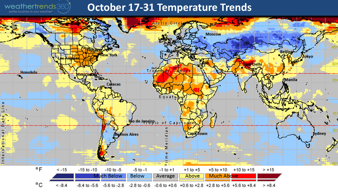
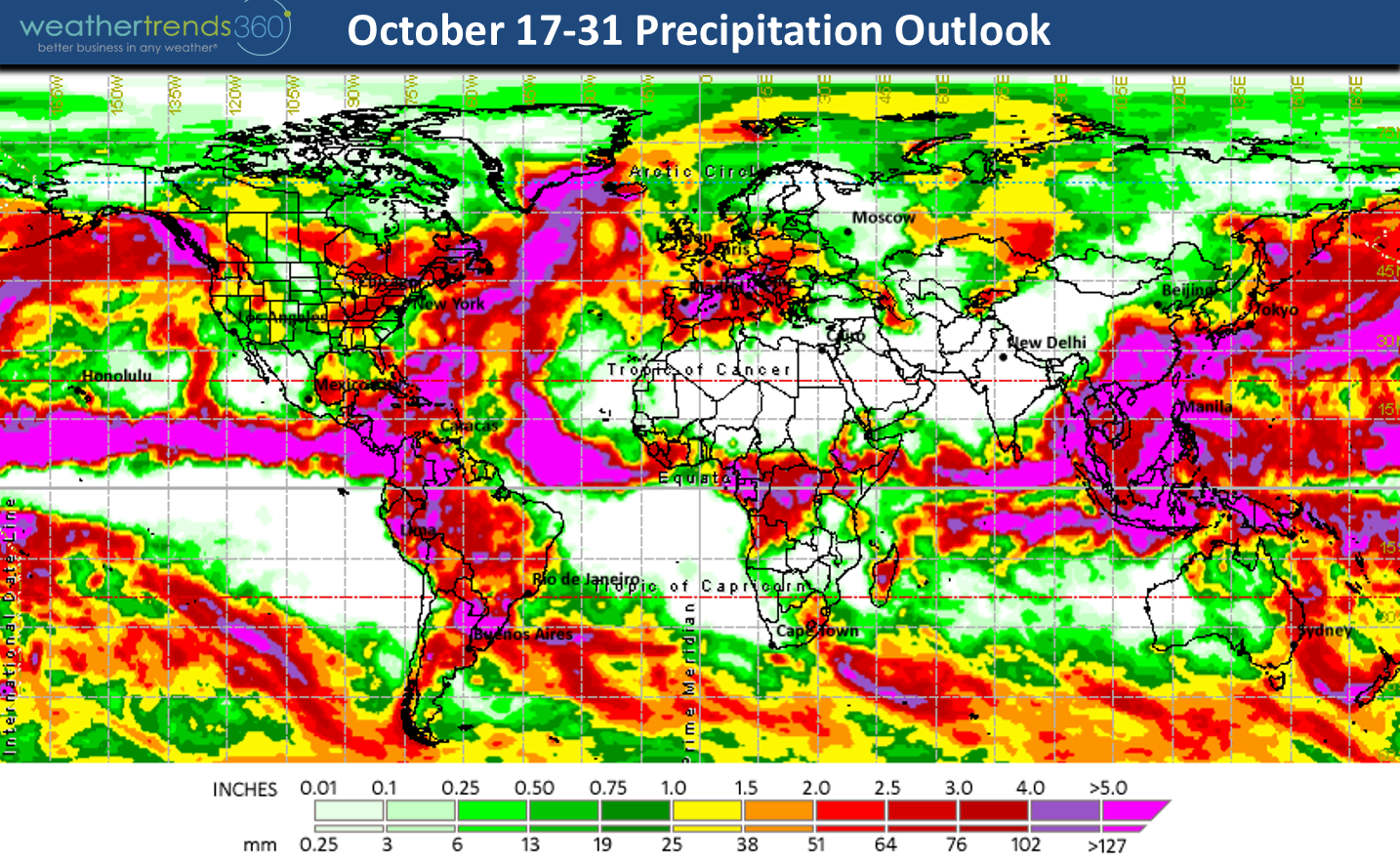
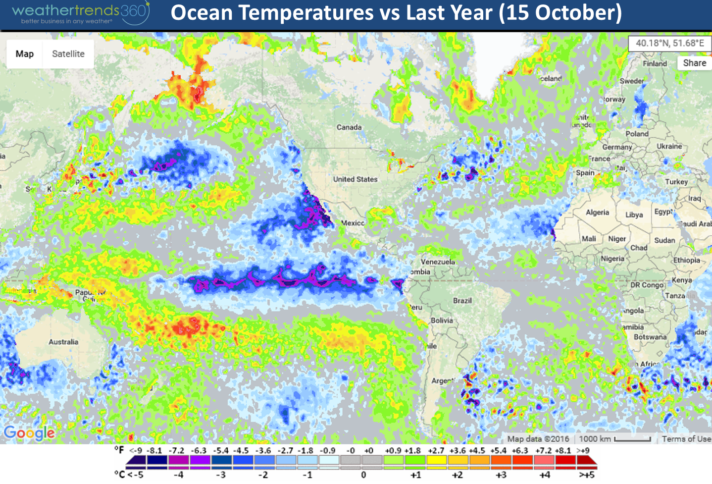
Next week (24-30 Oct) is again on the warm side trending #2 warmest of the past 25 years for the U.S. as a whole and #11 wettest of the past 25. The maps below show the last half of October around the world with the really cold spots in Russia, Kazakhstan and Eastern Europe. Russia/Siberia/Kazakhstan are trending 5 to 15 degrees colder than average for October making it the 3rd coldest in 25 years for them along with a rapidly increasing snow pack - a factor for a colder/snowier U.S. winter!

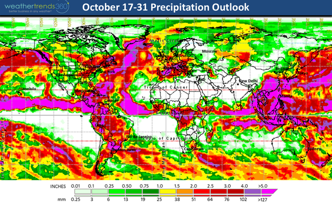
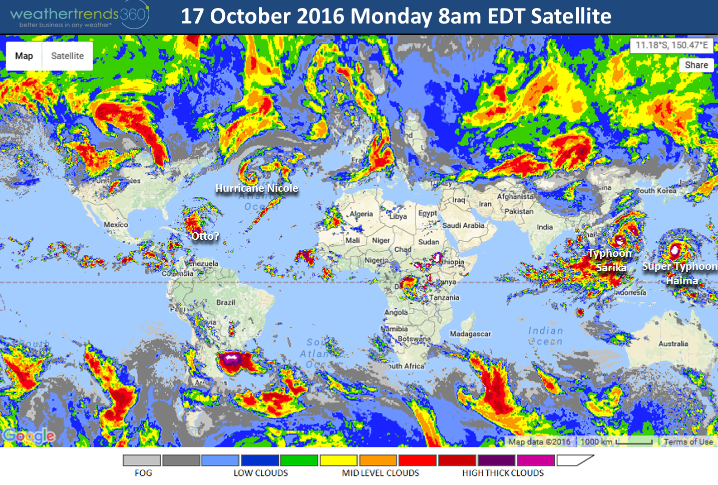
China will get a 1-2 punch with two Typhoons - weaker Cat 1 Sarika will impact the Southern China province of Hainan and much stronger soon to be Cat 5 Haima should pass between Hong Kong and Taiwan with landfall in Fujian province in Eastern China with more devastating flooding. It's been a very wet year for China in large part to many tropical systems. Current satellite this morning shows the 4 tropical systems around the globe.

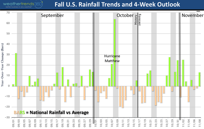
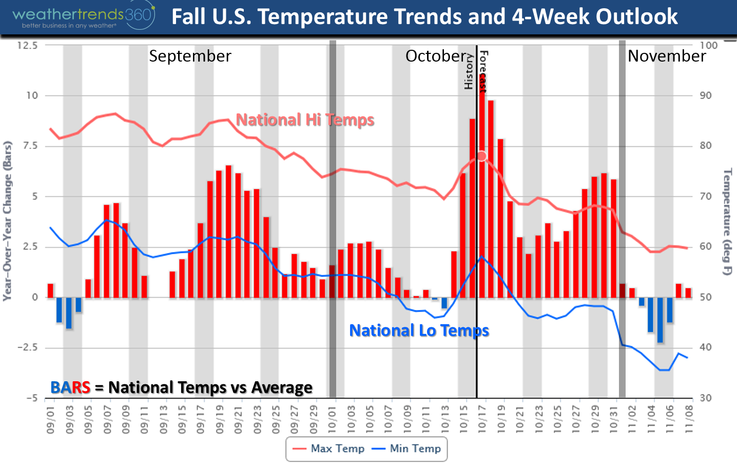
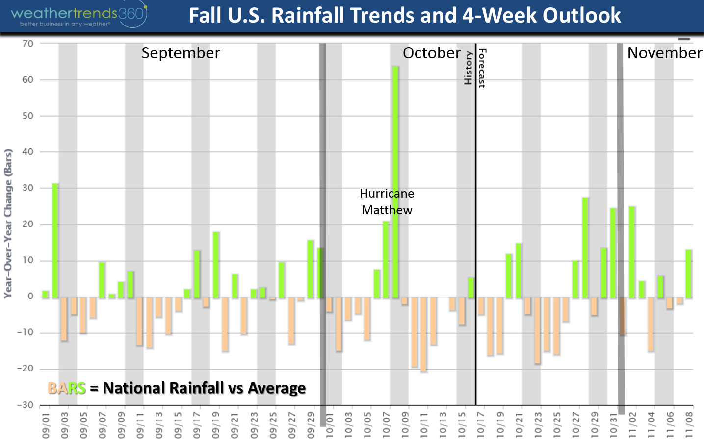
The temperature trends this Fall have obviously been warmer than average for the U.S. but that's likely to change as we head into November - April! The charts below show national temp and rainfall trends by day along with a 4-week outlook. First good cold snap likely in early November and again Thanksgiving.

 Here at Weather Trends we prefer to use statistics and 24 climate cycles to predict temp/rain/snow by week a year ahead for 21 million locations worldwide, but some shorter term climate cycles are starting to hint at a more severe U.S. Winter. Recall last year we were actually forecasting the 2nd warmest winter in 121 years with "one big storm" the 3rd week in January due to the mega El Nino while many others were talking about a brutal winter which wasn't the case.
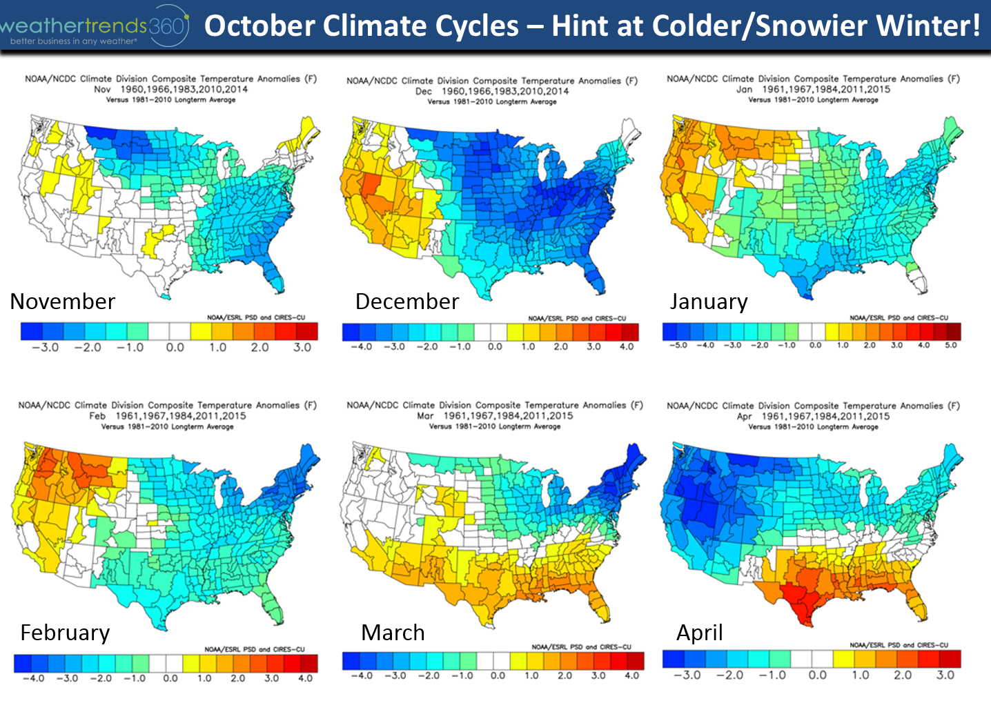
This year we're more in the camp for a cold/snowy winter from the Plains to Northeast with a weak Central based La Nina but also some other favorable climate factors and statistics. Meteorologists like to watch October weather as it can be a somewhat reliable indicator for the Winter weather ahead. One factor to watch is Russia/Siberia/Kazakhstan for cold/snow as early onset of the snow pack can make it much more likely to be cold/snowy in the U.S. in the heart of winter. We have that as mentioned above. The other factor is a very strong negative Arctic Oscillation here in October (pressure difference between the North Pole and Middle Latitudes). This strong pressure gradient in part helped to make the Jet Stream in the Northwest U.S. particularly strong with the recent events. Strongly negative AO Octobers combined with the weak central based La Nina, -EPO, +PDO, weak Sun and other cycles suggests a winter 2016-2017 more similar to 1960, 1966, 1983, 2010, 2014. Nothing in the oceanic cycles are remotely similar to last year so to expect another warm winter is highly unlikely.
Not a fan of using these weather analog methods as they are usually inconclusive giving answers like 5 of 15 years were cold, 4 warm and 6 average so they're 50/50 at best. But, when they line up with our statistical math based approach, long term trade secret 24 climate cycle approach and they all generally say the same thing (colder/snowier) then odds are much better with higher confidence. The maps below (Nov - Apr) are notour official forecast, but the above mentioned analog years would paint a long cold Winter-Spring 2017 in the U.S. (hint - that's kind of what we told clients 9 months ago). :) So for now enjoy Indian Summer!

Have a great week folks! - Capt Kirk out.
Last week (10-16 Oct) was dominated by headlines from major hurricane Matthew (Southeast U.S.) and Nicole (Bermuda). There was also heavy snow in Montana, a second round of frost and freezes for the Midwest, Great Lakes and Northeast and a series of powerful storms for the Pacific Northwest down into Northern California. For the U.S. overall the week was the coolest in 3 years but still the 5th warmest of the past 25 years with rainfall the 7th driest of the past 25 years (the exception was obviously the Middle Atlantic where recording flooding devastated the Eastern Carolina's).
This week (17-23 Oct) is classic Indian Summerwith some record heat for the Central and Eastern U.S. before another brief cool down arrives for the weekend in the Eastern half of the U.S. Overall the U.S. will trend #1 warmest of past 25 years and #12 wettest (average). Need to watch the Eastern Bahamas as a tropical wave is getting pretty strong and could become Tropical Storm Otto later this week. It SHOULD remain relatively weak and pass between North Carolina and Bermuda so minimal impact as of now but worth watching for changes. This would be the 16th tropical system of the season and 15th named storm (well above average with 45 days left in the 2016 season).
Next week (24-30 Oct) is again on the warm side trending #2 warmest of the past 25 years for the U.S. as a whole and #11 wettest of the past 25. The maps below show the last half of October around the world with the really cold spots in Russia, Kazakhstan and Eastern Europe. Russia/Siberia/Kazakhstan are trending 5 to 15 degrees colder than average for October making it the 3rd coldest in 25 years for them along with a rapidly increasing snow pack - a factor for a colder/snowier U.S. winter!
China will get a 1-2 punch with two Typhoons - weaker Cat 1 Sarika will impact the Southern China province of Hainan and much stronger soon to be Cat 5 Haima should pass between Hong Kong and Taiwan with landfall in Fujian province in Eastern China with more devastating flooding. It's been a very wet year for China in large part to many tropical systems. Current satellite this morning shows the 4 tropical systems around the globe.
The temperature trends this Fall have obviously been warmer than average for the U.S. but that's likely to change as we head into November - April! The charts below show national temp and rainfall trends by day along with a 4-week outlook. First good cold snap likely in early November and again Thanksgiving.
 Here at Weather Trends we prefer to use statistics and 24 climate cycles to predict temp/rain/snow by week a year ahead for 21 million locations worldwide, but some shorter term climate cycles are starting to hint at a more severe U.S. Winter. Recall last year we were actually forecasting the 2nd warmest winter in 121 years with "one big storm" the 3rd week in January due to the mega El Nino while many others were talking about a brutal winter which wasn't the case.
This year we're more in the camp for a cold/snowy winter from the Plains to Northeast with a weak Central based La Nina but also some other favorable climate factors and statistics. Meteorologists like to watch October weather as it can be a somewhat reliable indicator for the Winter weather ahead. One factor to watch is Russia/Siberia/Kazakhstan for cold/snow as early onset of the snow pack can make it much more likely to be cold/snowy in the U.S. in the heart of winter. We have that as mentioned above. The other factor is a very strong negative Arctic Oscillation here in October (pressure difference between the North Pole and Middle Latitudes). This strong pressure gradient in part helped to make the Jet Stream in the Northwest U.S. particularly strong with the recent events. Strongly negative AO Octobers combined with the weak central based La Nina, -EPO, +PDO, weak Sun and other cycles suggests a winter 2016-2017 more similar to 1960, 1966, 1983, 2010, 2014. Nothing in the oceanic cycles are remotely similar to last year so to expect another warm winter is highly unlikely.
Not a fan of using these weather analog methods as they are usually inconclusive giving answers like 5 of 15 years were cold, 4 warm and 6 average so they're 50/50 at best. But, when they line up with our statistical math based approach, long term trade secret 24 climate cycle approach and they all generally say the same thing (colder/snowier) then odds are much better with higher confidence. The maps below (Nov - Apr) are notour official forecast, but the above mentioned analog years would paint a long cold Winter-Spring 2017 in the U.S. (hint - that's kind of what we told clients 9 months ago). :) So for now enjoy Indian Summer!
Have a great week folks! - Capt Kirk out.