Star Date 17 October 2017 Tuesday Update
Captain's Log
17 Oct 2017 Tuesday UPDATE:
Deja'vu back to November 2014. We were in the middle of a hot October 2014 when Super Typhoon Nuri (cat 5) in the West Pacific decided to take a trip into the Siberian Sea off Alaska...then a couple weeks later the Arctic invaded the U.S. in middle November which ended up being the coldest November in 14 years.
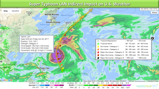
Are we headed for a repeat? It appears Typhoon Lan will become a cat 4, borderline cat 5 Super Typhoon as well with a similar track this weekend near Japan and then north from there. The old saying, what goes up...comes down applies here as these strong Fall typhoons tend to displace the jet stream and allow for cold shots into the Central and Eastern U.S. That is exactly what both the Euro and GFS are now showing for late October into November with a ridge building in the Western U.S. (warmer) with a big trough in the East (colder).
So, enjoy the milder weather building again this week as it appears Fall is coming back next week!
16 Oct 2017 Monday: Happy Monday!
It's not so happy in Ireland today where the remnants of once major Hurricane Ophelia are pounding the country. Peak wind gust we've see is 117 mph near Fastnet Ireland with 30+ foot waves off Cork, Ireland. CLICK ON IMAGES FOR LARGER VIEW
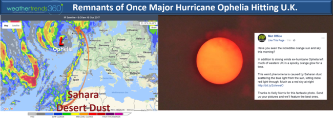
And the sun turned burnt orange across the U.K. prior to Ophelia moving in. This was due to the strong southerly winds blowing dust off the Sahara into the circulation of Ophelia.
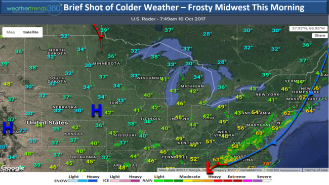
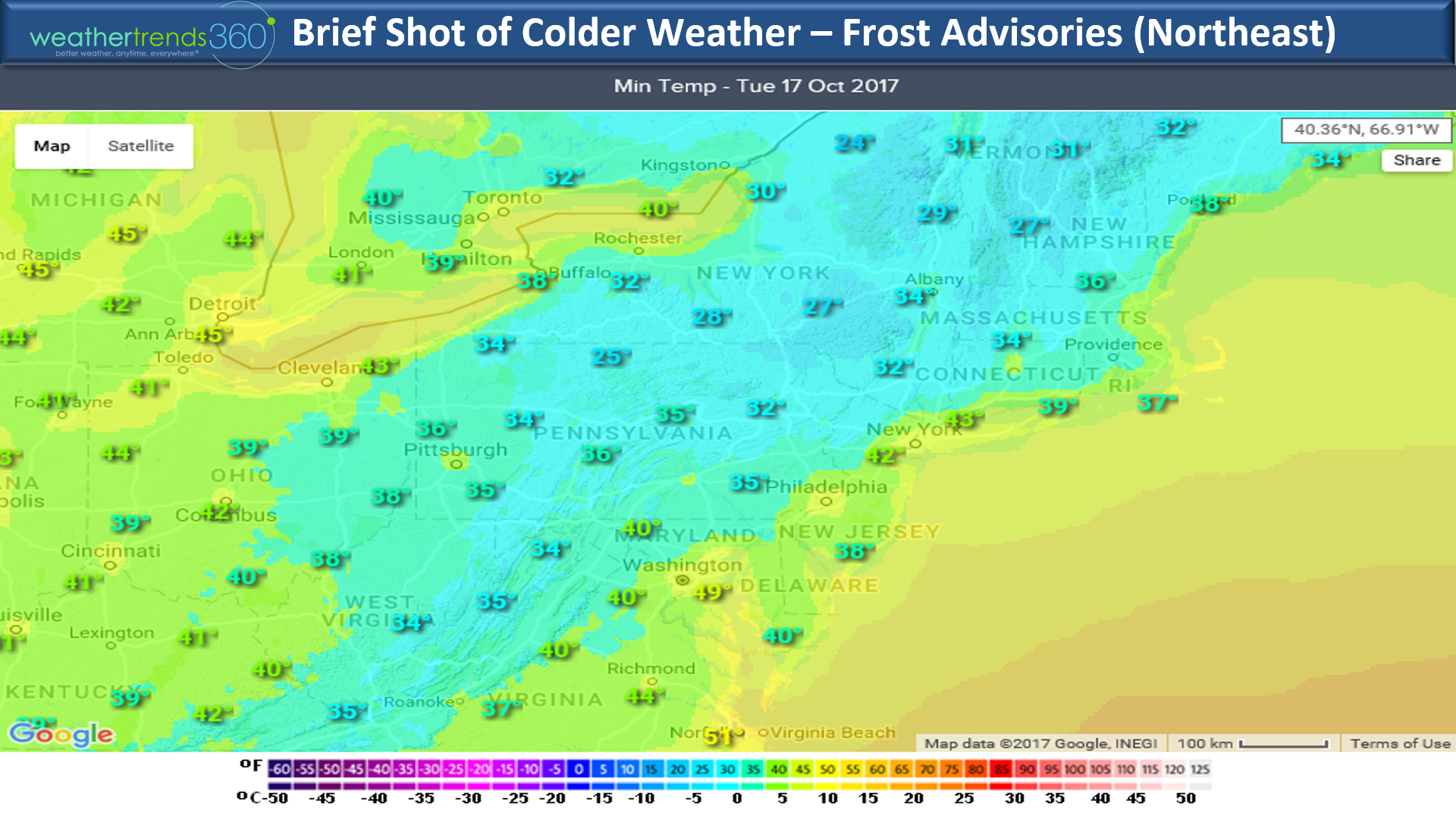
Back in the states it was a frosty morning in the Midwest this morning and that chilly area briefly invades the Northeast and South the next couple days. Look for frost and freezes across the interior Northeast Tuesday and Wednesday mornings.

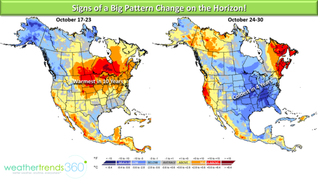
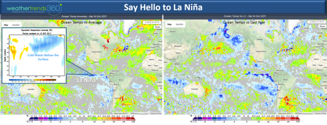
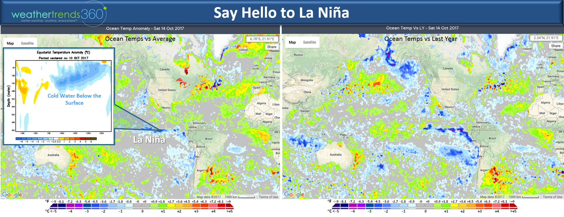
There are signs of a pattern change on the horizon as it appears Tropical Cyclone Lan in the West Pacific will become a super Typhoon heading up near Japan late this weekend into the Bearing Sea of Alaska next week. This SHOULD allow for a ridge to build in the Western U.S. with a downstream trough in the East ushering a colder pattern for late October into middle November for the Eastern U.S. Also signs we're headed for moderate La Nina as the Eastern Equatorial Pacific Ocean continues to cool with plenty of colder than average sub-surface water as well. Just another factor pointing toward a very different Winter ahead!
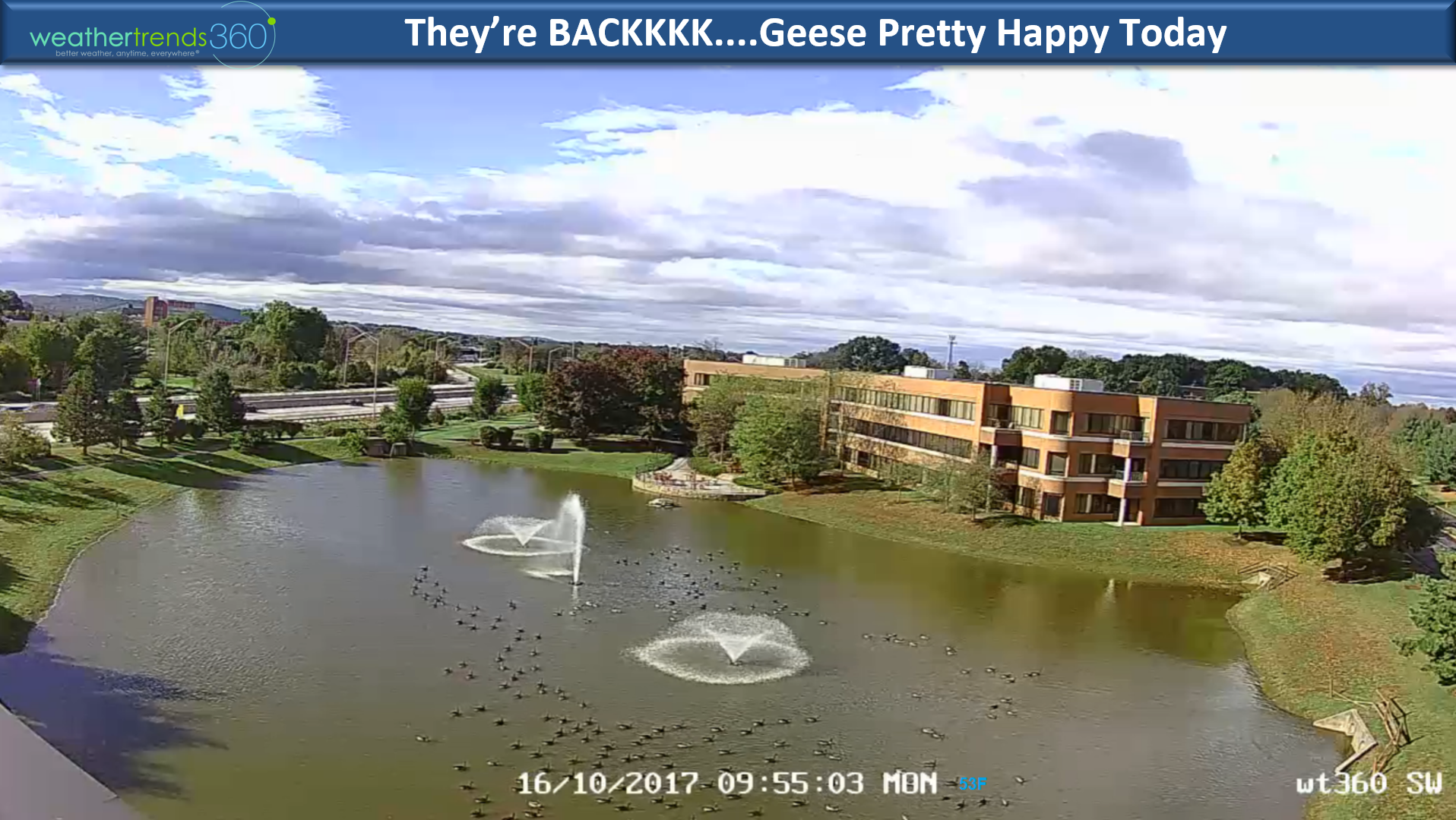
Outside wt360 headquarters (visit our 4 live roof top weather cams) the geese are back and seem pretty happy about the colder weather that's moved in after a gloomy mild weekend.

Have a great weekand follow us on Facebook and Twitter for daily updates.
- Capt Kirk out.
Deja'vu back to November 2014. We were in the middle of a hot October 2014 when Super Typhoon Nuri (cat 5) in the West Pacific decided to take a trip into the Siberian Sea off Alaska...then a couple weeks later the Arctic invaded the U.S. in middle November which ended up being the coldest November in 14 years.

Are we headed for a repeat? It appears Typhoon Lan will become a cat 4, borderline cat 5 Super Typhoon as well with a similar track this weekend near Japan and then north from there. The old saying, what goes up...comes down applies here as these strong Fall typhoons tend to displace the jet stream and allow for cold shots into the Central and Eastern U.S. That is exactly what both the Euro and GFS are now showing for late October into November with a ridge building in the Western U.S. (warmer) with a big trough in the East (colder).

So, enjoy the milder weather building again this week as it appears Fall is coming back next week!
16 Oct 2017 Monday: Happy Monday!
It's not so happy in Ireland today where the remnants of once major Hurricane Ophelia are pounding the country. Peak wind gust we've see is 117 mph near Fastnet Ireland with 30+ foot waves off Cork, Ireland. CLICK ON IMAGES FOR LARGER VIEW

And the sun turned burnt orange across the U.K. prior to Ophelia moving in. This was due to the strong southerly winds blowing dust off the Sahara into the circulation of Ophelia.
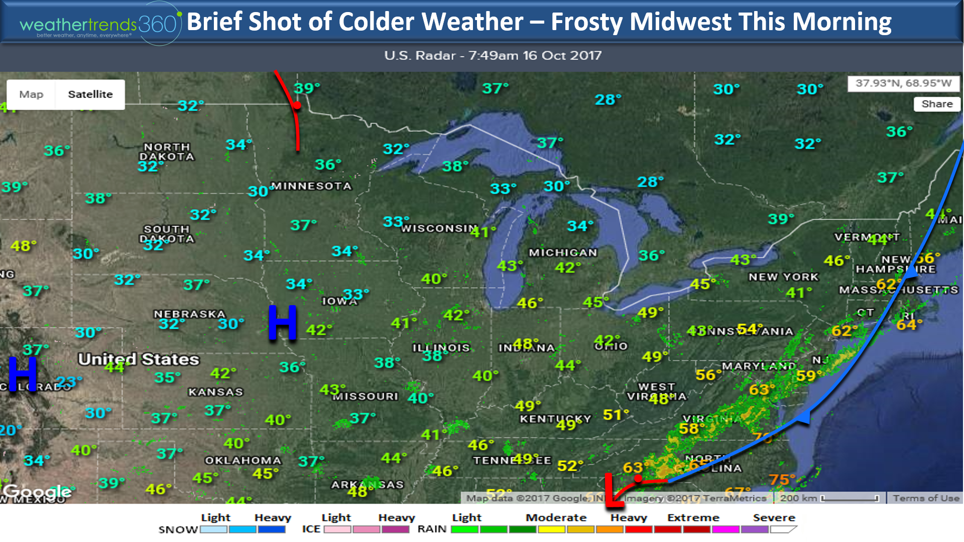
Back in the states it was a frosty morning in the Midwest this morning and that chilly area briefly invades the Northeast and South the next couple days. Look for frost and freezes across the interior Northeast Tuesday and Wednesday mornings.
There are signs of a pattern change on the horizon as it appears Tropical Cyclone Lan in the West Pacific will become a super Typhoon heading up near Japan late this weekend into the Bearing Sea of Alaska next week. This SHOULD allow for a ridge to build in the Western U.S. with a downstream trough in the East ushering a colder pattern for late October into middle November for the Eastern U.S. Also signs we're headed for moderate La Nina as the Eastern Equatorial Pacific Ocean continues to cool with plenty of colder than average sub-surface water as well. Just another factor pointing toward a very different Winter ahead!
Outside wt360 headquarters (visit our 4 live roof top weather cams) the geese are back and seem pretty happy about the colder weather that's moved in after a gloomy mild weekend.
Have a great weekand follow us on Facebook and Twitter for daily updates.
- Capt Kirk out.