Star Date: 28 March 2018 Wednesday
Captain's Log
28 March 2018 Wednesday Update:
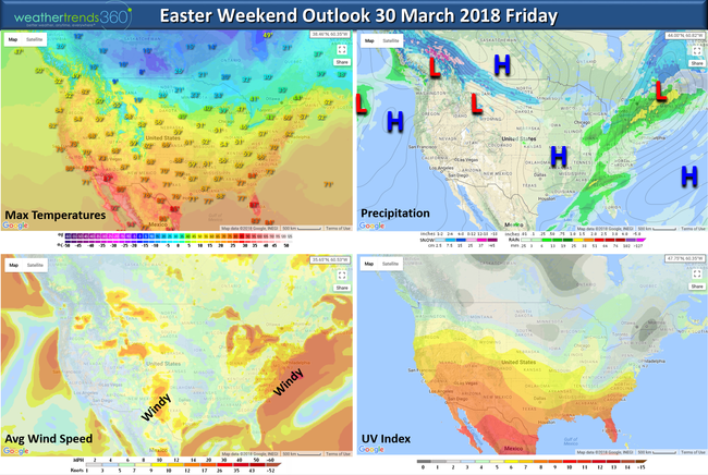
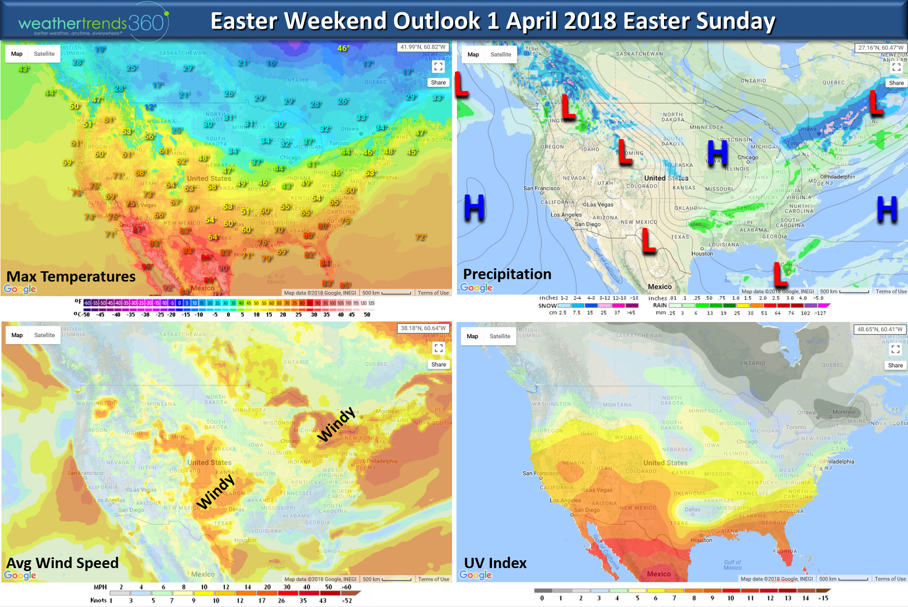
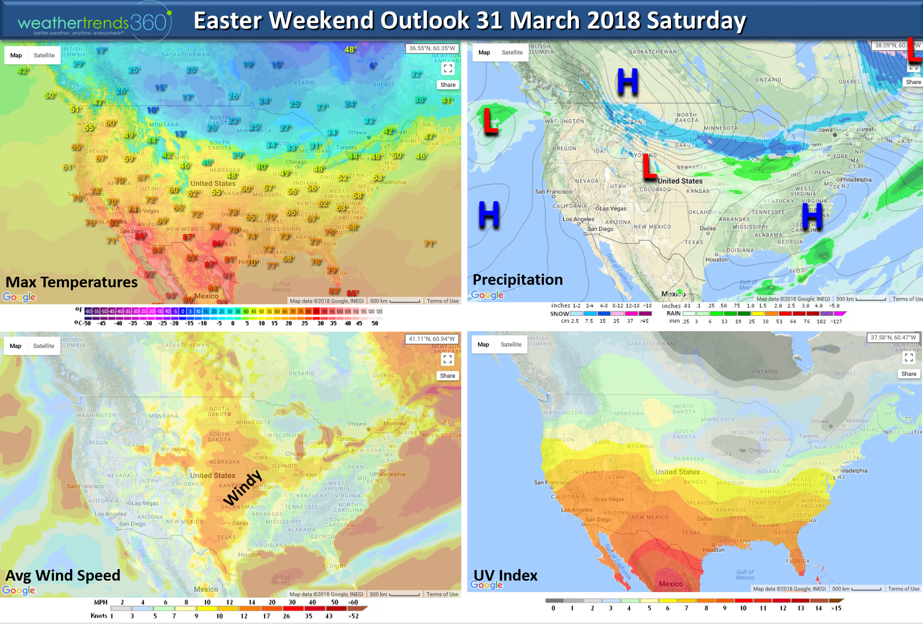
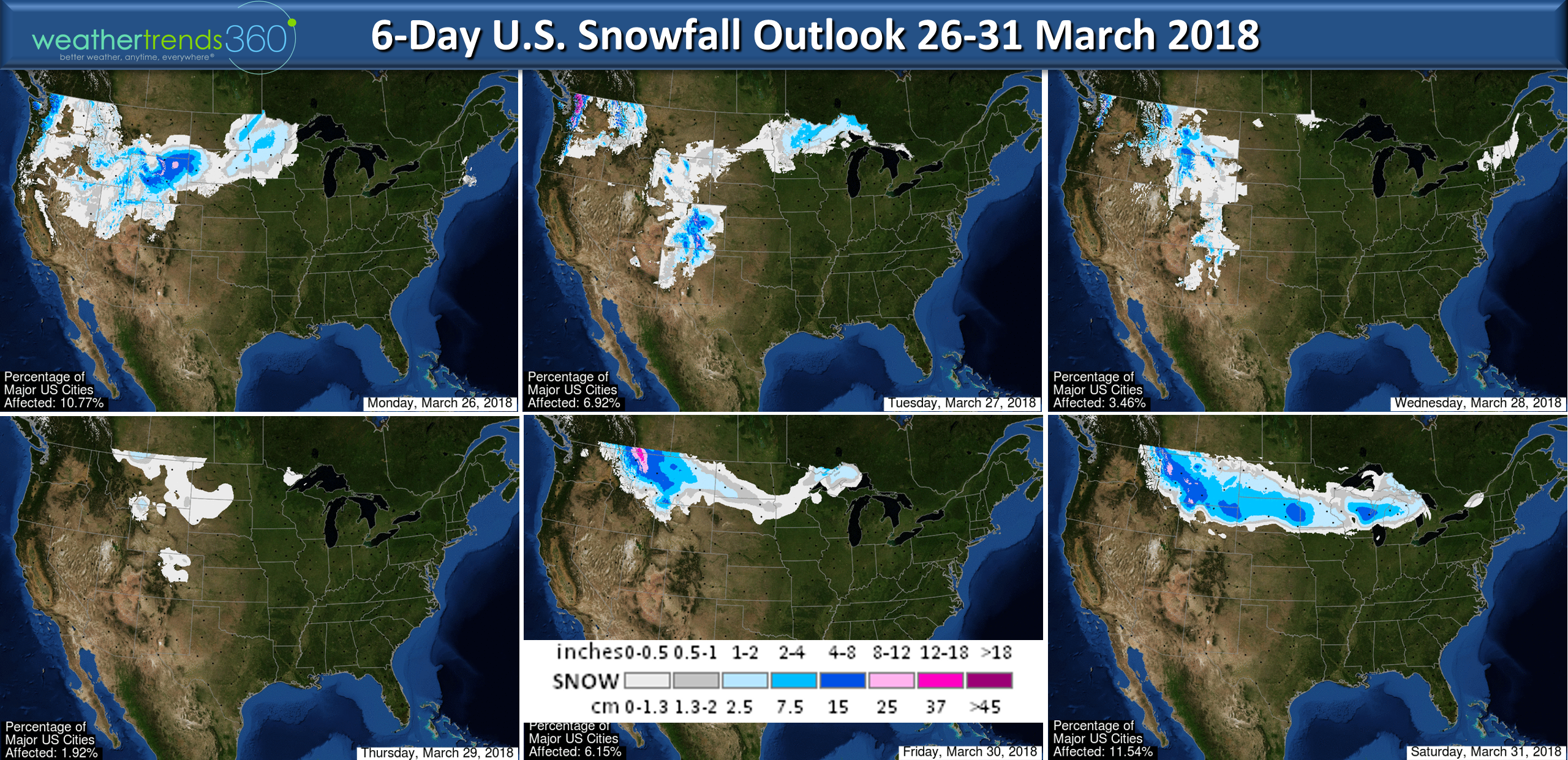
Easter is coming in 2 weeks earlier than last year but also shifting into a very cold period for the Midwest and Northeast. Last year was a record hot Easter for many cities in the Eastern U.S. but this year will trend some 30 degrees colder. As an example, New York City last year was 88F -> 57F, Bethlehem PA 85F -> 54F, Boston 86F -> 54F, Chicago 73F -> 44F, Minneapolis 66F -> 33F. The maps below show the Friday - Sunday weekend outlook which shows a reinforcing shot of cold air and snow moving into the Midwest and eventually the Northeast. CLICK ON IMAGES FOR LARGER VIEW.
FRIDAY

SATURDAY

EASTER SUNDAY
Have a great weekend!
26 March 2018: Happy Monday! :)
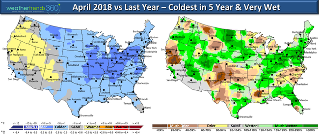
March will end up the coldest in 4 years (below average U.S. temps) and snowiest in 13 years (much above average) for the U.S. overall and April will very likely continue the colder, wetter and snowier trends. CLICK ON IMAGES FOR LARGER VIEW.
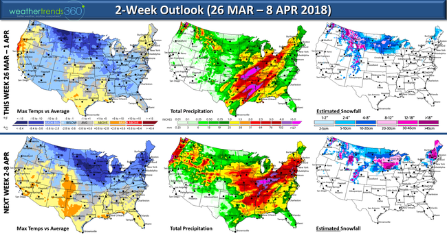
The 2-week outlook above continues to show cold and very wet for the Eastern half of the country while the West warms up and dries out. There will be a taste of Spring in the East midweek but then a reinforcing shot of colder air for the Easter weekend.

Snow continues to fall for the northern tier of the U.S. well into April. The severe thunderstorm/tornado season is likely to get very active in April with frequently cold fronts clashing with warmer air to the South.
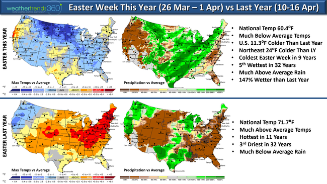
This Easter week(26 Mar - 1 Apr) is about as polar opposite as you can get going from record hot last year to cold this year. Easter does shift up 2 weeks earlier this year but unfortunately shifts into a very poor week for retailers and seasonal suppliers. The Northeast as an example had low 80s last year while this year will average some 24 degrees colder.
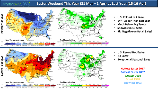
The Easter weekend (31 Mar - 1 Apr) isn't much better either, although the big cities from DC to Boston will trend a bit above average but still some 24 degrees colder than last year. The North Central U.S. will be downright frigid and Winter like with a reinforcing shot of Arctic air.
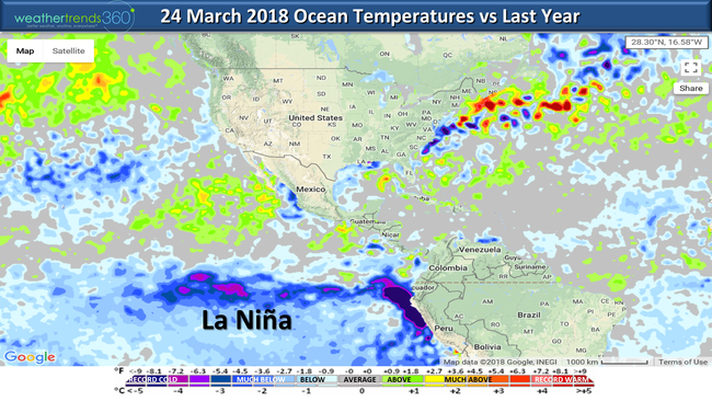
The dramatically colder and snowier trends are in large part to the Pacific Ocean cycles (La Nina and PDO) trending much colder than this time last year. These colder oceanic trends combined with a very weak sun are setting the stage a cool/wet Spring, nice May, average but wet Summer and potentially very cold Fall 2018. It also brings high risk to yet another very active hurricane season...and that's all we have to say about that for now. April 2018 shows the dramatically colder and stormier trends this year with the U.S. overall expected to be the coldest in 5 years and possibly one of the wettest of the past 30 years...and yes...more snowfall from the Midwest to Northeast.
We hope you have a great week! Look for frequent updates on Facebook and Twitter. - Captain Kirk out.
Easter is coming in 2 weeks earlier than last year but also shifting into a very cold period for the Midwest and Northeast. Last year was a record hot Easter for many cities in the Eastern U.S. but this year will trend some 30 degrees colder. As an example, New York City last year was 88F -> 57F, Bethlehem PA 85F -> 54F, Boston 86F -> 54F, Chicago 73F -> 44F, Minneapolis 66F -> 33F. The maps below show the Friday - Sunday weekend outlook which shows a reinforcing shot of cold air and snow moving into the Midwest and eventually the Northeast. CLICK ON IMAGES FOR LARGER VIEW.
FRIDAY
SATURDAY
EASTER SUNDAY

Have a great weekend!
26 March 2018: Happy Monday! :)
March will end up the coldest in 4 years (below average U.S. temps) and snowiest in 13 years (much above average) for the U.S. overall and April will very likely continue the colder, wetter and snowier trends. CLICK ON IMAGES FOR LARGER VIEW.
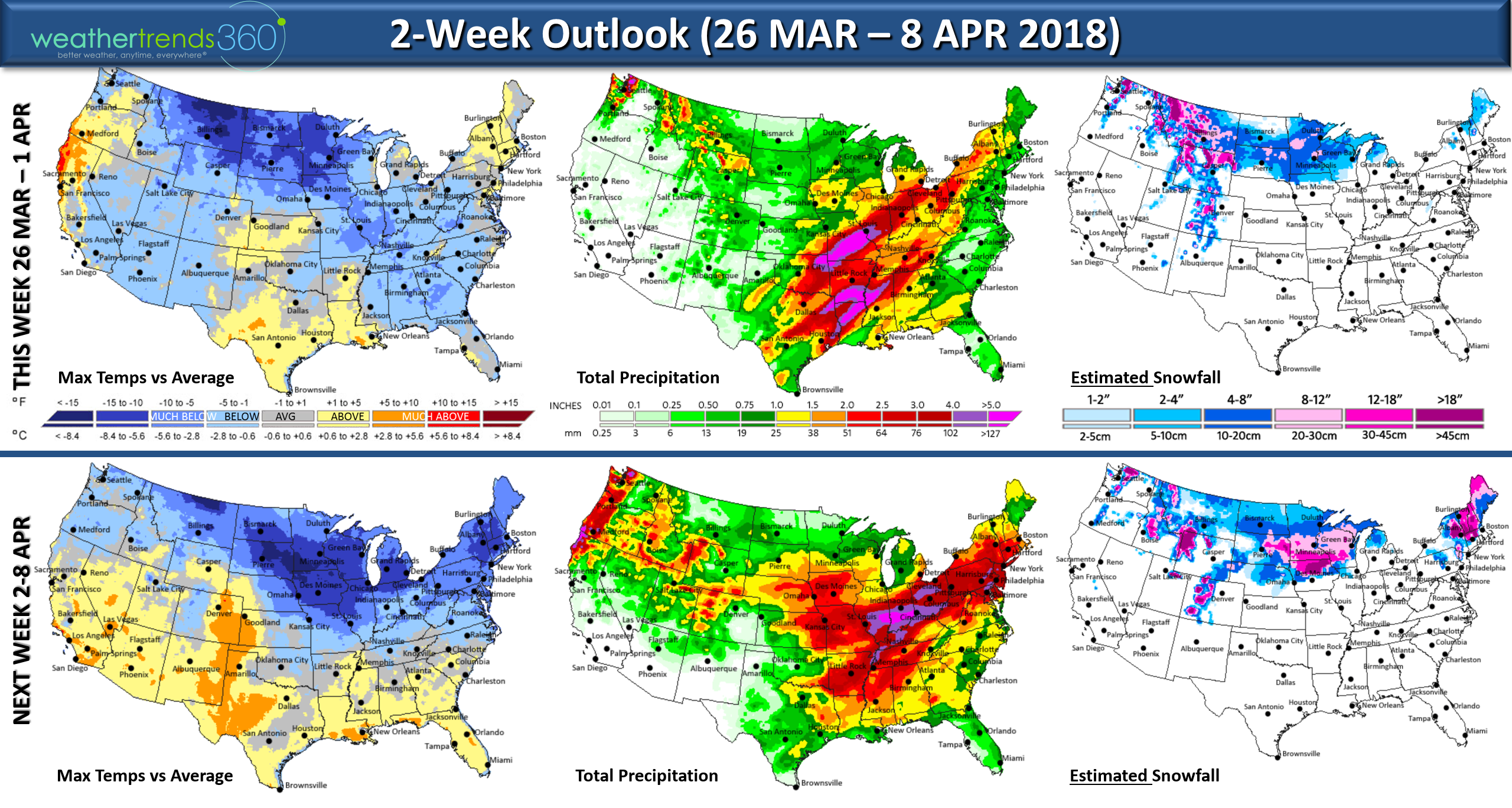
The 2-week outlook above continues to show cold and very wet for the Eastern half of the country while the West warms up and dries out. There will be a taste of Spring in the East midweek but then a reinforcing shot of colder air for the Easter weekend.
Snow continues to fall for the northern tier of the U.S. well into April. The severe thunderstorm/tornado season is likely to get very active in April with frequently cold fronts clashing with warmer air to the South.

This Easter week(26 Mar - 1 Apr) is about as polar opposite as you can get going from record hot last year to cold this year. Easter does shift up 2 weeks earlier this year but unfortunately shifts into a very poor week for retailers and seasonal suppliers. The Northeast as an example had low 80s last year while this year will average some 24 degrees colder.

The Easter weekend (31 Mar - 1 Apr) isn't much better either, although the big cities from DC to Boston will trend a bit above average but still some 24 degrees colder than last year. The North Central U.S. will be downright frigid and Winter like with a reinforcing shot of Arctic air.

The dramatically colder and snowier trends are in large part to the Pacific Ocean cycles (La Nina and PDO) trending much colder than this time last year. These colder oceanic trends combined with a very weak sun are setting the stage a cool/wet Spring, nice May, average but wet Summer and potentially very cold Fall 2018. It also brings high risk to yet another very active hurricane season...and that's all we have to say about that for now. April 2018 shows the dramatically colder and stormier trends this year with the U.S. overall expected to be the coldest in 5 years and possibly one of the wettest of the past 30 years...and yes...more snowfall from the Midwest to Northeast.

We hope you have a great week! Look for frequent updates on Facebook and Twitter. - Captain Kirk out.