Star Date 5 September 2017 Tuesday
Captain's Log
Hard to say Happy Tuesday with so much potential destruction on the horizon.
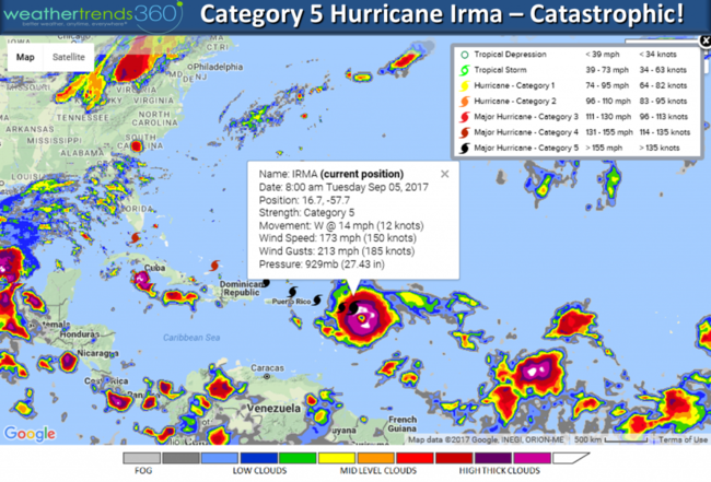
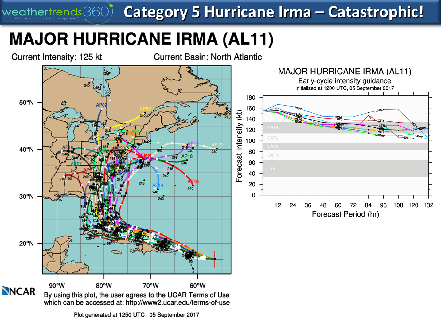
Hurricane Irmais now a category 5 hurricane with sustained winds of 175 mph and gusts to 213 mph! It's East of Barbuda heading toward the Leeward Islands. This will be a catastrophic and deadly hurricane as it makes its way toward the U.S. CLICK ON IMAGES FOR LARGER VIEW
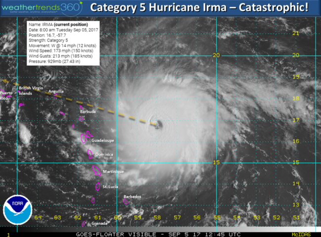
The hurricane has been shifting south in response to a strong high pressure to the north and this brings it closer to the U.S. Virgin Islands, Puerto Rico, Dominican Republic, Cuba, Southern Bahamas and ultimately South Florida.
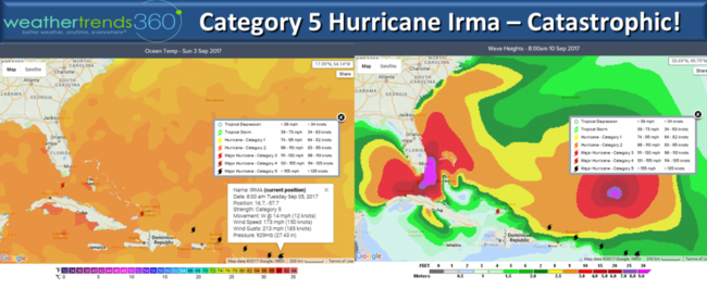
While most of the models want to curve Irma right up Florida there is still a little doubt on this in light of what appears to be a strong blocking cold high pressure in the Northeast later this week. Right now the high is forecast to move into the Atlantic allowing Irma to make the typical right turn up and inland U.S. East Coast but again there is concern here that Irma continues West into the Gulf of Mexico which only a handful of models are suggesting. The mountains are very tall on Dominica and Cuba so this SHOULD help weaken Irma from Cat 5 back to Cat 4 but still an extremely dangerous storm. A hurricane this powerful has more energy than 15,000 nuclear bombs per NASA so please take it seriously as even Texas is not out of the woods with this, nor is the Northeast.

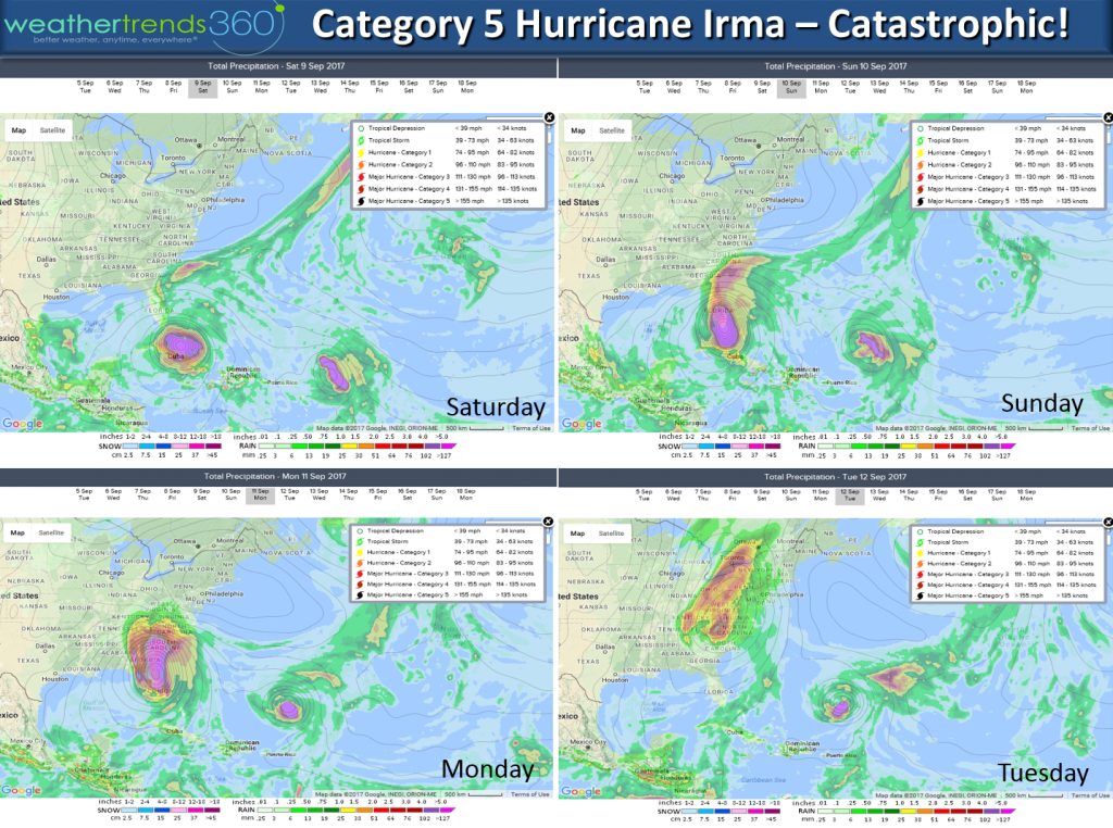
It is almost certain the U.S. will take a direct hit from one of the most catastrophic hurricanes on record but sadly these storms don't always behave as models suggest. Key West Florida is the most likely U.S. city to have catastrophic damage this weekend, beyond that...TBD! Miami is second highest U.S. city at risk.
The cold trends that have plagued the Eastern U.S. in August will continue the front half of September with the Northeast having the coldest 1-15 September in 23 years and 2nd wettest.
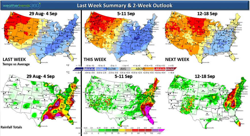
The past couple years have been record hot in the Northeast so the year-over-year change toward colder weather is huge - most in decades. For the U.S. overall, the front half of September is the coldest in 9 years and wettest in 6 years.
We will have frequent daily updates on Irma and Jose behind it on our Facebook and Twitter pages.
STAY SAFE!!!! - Capt Kirk out.
Hurricane Irmais now a category 5 hurricane with sustained winds of 175 mph and gusts to 213 mph! It's East of Barbuda heading toward the Leeward Islands. This will be a catastrophic and deadly hurricane as it makes its way toward the U.S. CLICK ON IMAGES FOR LARGER VIEW

The hurricane has been shifting south in response to a strong high pressure to the north and this brings it closer to the U.S. Virgin Islands, Puerto Rico, Dominican Republic, Cuba, Southern Bahamas and ultimately South Florida.

While most of the models want to curve Irma right up Florida there is still a little doubt on this in light of what appears to be a strong blocking cold high pressure in the Northeast later this week. Right now the high is forecast to move into the Atlantic allowing Irma to make the typical right turn up and inland U.S. East Coast but again there is concern here that Irma continues West into the Gulf of Mexico which only a handful of models are suggesting. The mountains are very tall on Dominica and Cuba so this SHOULD help weaken Irma from Cat 5 back to Cat 4 but still an extremely dangerous storm. A hurricane this powerful has more energy than 15,000 nuclear bombs per NASA so please take it seriously as even Texas is not out of the woods with this, nor is the Northeast.
It is almost certain the U.S. will take a direct hit from one of the most catastrophic hurricanes on record but sadly these storms don't always behave as models suggest. Key West Florida is the most likely U.S. city to have catastrophic damage this weekend, beyond that...TBD! Miami is second highest U.S. city at risk.

The cold trends that have plagued the Eastern U.S. in August will continue the front half of September with the Northeast having the coldest 1-15 September in 23 years and 2nd wettest.
The past couple years have been record hot in the Northeast so the year-over-year change toward colder weather is huge - most in decades. For the U.S. overall, the front half of September is the coldest in 9 years and wettest in 6 years.
We will have frequent daily updates on Irma and Jose behind it on our Facebook and Twitter pages.
STAY SAFE!!!! - Capt Kirk out.