Warmer Weather Arrives In the East, But It Comes At a Cost
Breaking Weather Events
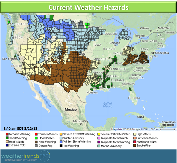
A powerful storm is developing across the West on Thursday bringing multiple weather hazards across the U.S. through the upcoming weekend. The U.S. weather hazards map is lighting up like a Christmas tree with anything fromwinter storm warningsto wildfire alerts.
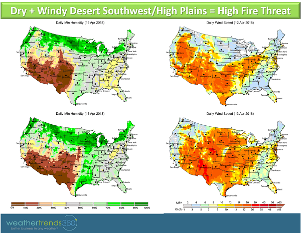
 Hot and dry weather across the Desert Southwest and High Plains combined with strong winds will be prime for wildfire development. Winds will gust upwards of 50 mph and relative humidity values will drop as low as 5% while temperatures soar into the 90s and 100s. Under these conditions even a tiny spark can touch off a wildfire. In addition to the wildfire threat, areas of blowing dust are also possible across the Desert Southwest.
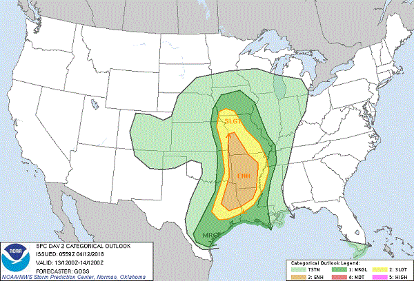
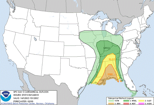
 Friday afternoon and into the night time could be rather tumultuous from East Texas and Louisiana northward to Iowa as conditions are ripe for a significant severe weather outbreak. This system will have plenty of moisture to work with as it taps moisture from the Gulf of Mexico. The atmosphere will become very unstable and will be prime for explosive thunderstorm development. Large hail, damaging winds, and tornadoes will be a threat with this system. Further severe thunderstorm development is expected into Saturday across parts of the Deep South, particularly along the central Gulf Coast. The Storm Prediction Center has highlighted areas of severe thunderstorm risk for Friday and Saturday, see maps below.
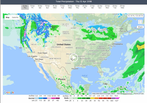
 In addition to the severe thunderstorm threat, heavy rain of several inches is also possible. For an area that is already experiencing river flooding, particularly in the Lower Mississippi Valley, further heavy rain in the South will only exacerbate flooding. The animation below shows the precipitation forecast for the next few days showing heavy rain/thunderstorms developing across thesouthern Plains and Deep South.
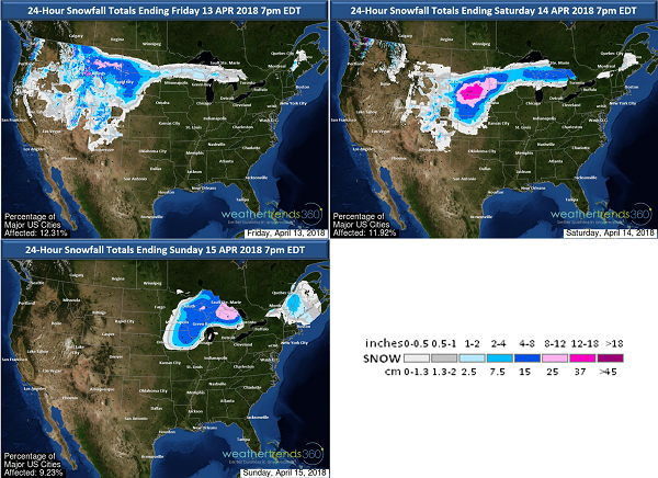
If you watched the animation above you may have noticed the heavy snow on the north and west side of the storm system. That's right, winter is done through with us just yet. Heavy snow is moving across the Rockies and Intermountain West Thursday morning. The snow will then move into parts of the northern Plains with over a foot of snow possible through Friday morning. Snow then spreads east to the northern Mississippi Valley by Friday morning. Windy conditions will accompany the snowfall and some locations may reach blizzard criteria: 3 hours of longer of sustained winds or frequent gusts to 35 mph or greater, and considerable falling and/or blowing snow. Widespread 6-12'' of snow is possible across northern Nebraska, South Dakota, and western Minnesota. There will also be a threat of freezing rain across southern Minnesota and the norther part of lower Michigan.
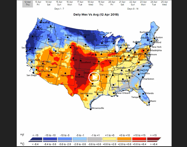
Ahead of the system, temperatures will turn milder after weeks of downright cold weather. Temperatures could top 80F in parts of the Northeast by Saturday, however, the forecast for high temperatures will be tricky. A back-door cold front is forecast to move through with a sharp temperature gradient from 70s to 40s. These types of fronts tend to work their way south or southwest from the Atlantic seaboard during the spring months. There is some uncertainty as to how far south this front progressesand some areas may be disappointed by high temperatures on Saturday if the front manages to work its way through. Regardless of the back-door front, the warm weather will not last long anyway as the main system's cold front plows through late Sunday and Monday bringing a wet and much colder start to the new work week. The animation below shows the max temperature forecast versus normal for the next days.
Behind the storm there will be another threat of a freeze possibly reaching as far south as North Texas late in the weekend. Colder than normal conditions settled back in across much of the eastern U.S. for next week.
While we'll get a taste of spring here in the East, it will come at a price with wildfire threats, blizzard conditions, heavy rain, and severe storms. Clearly, winter isn't going without a fight. Stay safe!
Hot and dry weather across the Desert Southwest and High Plains combined with strong winds will be prime for wildfire development. Winds will gust upwards of 50 mph and relative humidity values will drop as low as 5% while temperatures soar into the 90s and 100s. Under these conditions even a tiny spark can touch off a wildfire. In addition to the wildfire threat, areas of blowing dust are also possible across the Desert Southwest.Friday afternoon and into the night time could be rather tumultuous from East Texas and Louisiana northward to Iowa as conditions are ripe for a significant severe weather outbreak. This system will have plenty of moisture to work with as it taps moisture from the Gulf of Mexico. The atmosphere will become very unstable and will be prime for explosive thunderstorm development. Large hail, damaging winds, and tornadoes will be a threat with this system. Further severe thunderstorm development is expected into Saturday across parts of the Deep South, particularly along the central Gulf Coast. The Storm Prediction Center has highlighted areas of severe thunderstorm risk for Friday and Saturday, see maps below.In addition to the severe thunderstorm threat, heavy rain of several inches is also possible. For an area that is already experiencing river flooding, particularly in the Lower Mississippi Valley, further heavy rain in the South will only exacerbate flooding. The animation below shows the precipitation forecast for the next few days showing heavy rain/thunderstorms developing across thesouthern Plains and Deep South.If you watched the animation above you may have noticed the heavy snow on the north and west side of the storm system. That's right, winter is done through with us just yet. Heavy snow is moving across the Rockies and Intermountain West Thursday morning. The snow will then move into parts of the northern Plains with over a foot of snow possible through Friday morning. Snow then spreads east to the northern Mississippi Valley by Friday morning. Windy conditions will accompany the snowfall and some locations may reach blizzard criteria: 3 hours of longer of sustained winds or frequent gusts to 35 mph or greater, and considerable falling and/or blowing snow. Widespread 6-12'' of snow is possible across northern Nebraska, South Dakota, and western Minnesota. There will also be a threat of freezing rain across southern Minnesota and the norther part of lower Michigan.

Ahead of the system, temperatures will turn milder after weeks of downright cold weather. Temperatures could top 80F in parts of the Northeast by Saturday, however, the forecast for high temperatures will be tricky. A back-door cold front is forecast to move through with a sharp temperature gradient from 70s to 40s. These types of fronts tend to work their way south or southwest from the Atlantic seaboard during the spring months. There is some uncertainty as to how far south this front progressesand some areas may be disappointed by high temperatures on Saturday if the front manages to work its way through. Regardless of the back-door front, the warm weather will not last long anyway as the main system's cold front plows through late Sunday and Monday bringing a wet and much colder start to the new work week. The animation below shows the max temperature forecast versus normal for the next days.
Behind the storm there will be another threat of a freeze possibly reaching as far south as North Texas late in the weekend. Colder than normal conditions settled back in across much of the eastern U.S. for next week.
While we'll get a taste of spring here in the East, it will come at a price with wildfire threats, blizzard conditions, heavy rain, and severe storms. Clearly, winter isn't going without a fight. Stay safe!