2018 Atlantic Hurricane Season Review
We're in the throes of the hustle and bustle of the holiday season, and while you were busy shopping, chopping down the Christmas tree, or just 'Netflix and chilling', the 2018 Atlantic Hurricane season quietly slipped away, officially, on November 30th. It was an active season with 4 land-falling storms in the U.S. Unfortunately, the season proved to be disastrous for portions of the Southeast as 2 of these land-falling storms were epic.
The 2018 Season Begins
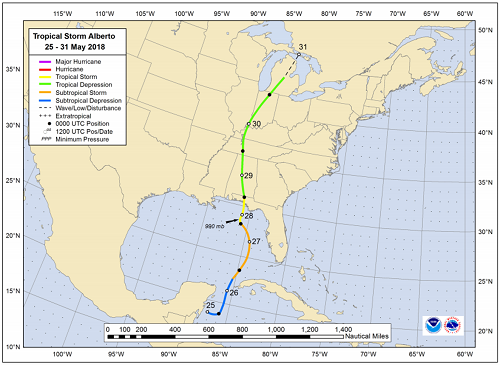
The 2018 Atlantic Hurricane season began a bit early on May 25th with the development of a subtropical depression that would become Tropical Storm Alberto. Alberto was not only the first storm to form but also the first storm to make landfall in the U.S. Alberto made landfall as a tropical storm near the Bay and Walton County lines in the Florida Panhandle, about halfway between Pensacola and Tallahassee, FL (see track map below). Alberto brought flooding storm surge and freshwater flooding from Florida to the Mid-Atlantic.
After Alberto, there was a lull in the activity during June with storms returning in July including Hurricanes Beryl and Chris, neither striking the U.S. In August, there were 2 fish storms: Tropical Storms Debby and Ernesto. However, in September, things took a turn for the worse as not only did we see a very active month with 7 storms, but one of those storms would go down in the record books causing historic flooding in the Carolinas.
Devastation as the 1st of 2 Historic Storms Makes Landfall in the U.S.
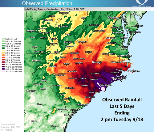
In mid-September, Hurricane Florence made landfall near Wrightsville Beach, NC on Saturday September 15th. Although weakening from her previous status as a "Major" hurricane prior to landfall, Florence still dropped an immense amount of rain as depicted in the observed rainfall map below causing major flooding in the eastern Carolinas. According to the National Weather Service (NWS), Hurricane Florence was the wettest tropical cyclone on record in the Carolinas. Florence dumped FEET of rain on some locations on top of a record-breaking storm surge which was a recipe for a flooding disaster.
While Florence stole the hurricane headlines for September, and rightly so, Tropical Storm Gordon was another land-falling September storm. Gordon made two landfalls, one in Key Largo, FL around the 3rd of September and another near the Mississippi/Alabama border on the 4th. Gordon produced heavy rainfall and isolated flooding but had no where near the impact that Florence had.
Strongest Hurricane On Record For Florida Panhandle
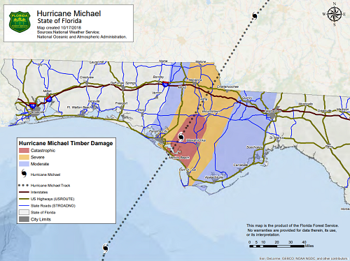
October was the final month of the season to produce storms, among them was historic Major Hurricane Michael. Michael was the strongest hurricane on record to make landfall in the Florida panhandle. At landfall on October 10th, Michael's sustained wind speeds were an impressive 155 mph and the minimum central pressure was 919 mb, a healthy category 4 hurricane. Storm surge and wind damage caused catastrophic damage across the Florida Panhandle, the western Big Bend area of Florida, southwest Georgia, and southeast Alabama, according to the NWS. Homes and businesses were destroyed, new inlets were carved out, and forests were decimated by Michael's tremendous strength.
The 2018 Atlantic Hurricane Season, which was early to start, also came to an early end on October 31st, as the last storm to form of the season, Hurricane Oscar, dissipated out in the open Atlantic.
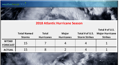
How Did Our Forecast Stack-Up?
While we currently have reindeer and snow on the mind, it was way back when we had the Easter Bunny and warmer weather on the mind that wt360 issued our 2018 Atlantic Hurricane Season Forecast. But just how well did our forecast stack up to what actually happened? Let's compare:
The Atlantic 2018 Hurricane Season Forecast/Actual At A Glance
 Actual Storm Tracks

wt360 Forecast from April 2018 - Hurricanes Florence and Michael made landfall in the center of the highest damage risk (red) areas!

The wt360 2018 forecast remained constant even while others were downgrading their storm forecasts mid-season due to the impending El Nino and cooler than normal sea surface temperatures in the tropical Atlantic Ocean and Caribbean Sea. Unfortunately, the 2018 season proved to be quite active with devastating consequences for the Southeast. Adieu 2018 Atlantic Hurricane Season, you won't be missed.