The Weather is Beginning to Feel A Lot Like Autumn
Captain's Log
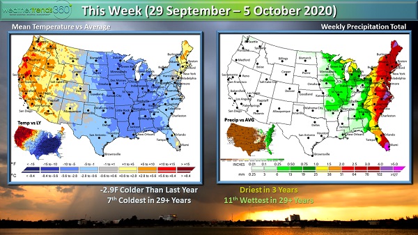
The first week of autumn 2020 is in the books and it's beginning to feel a lot more seasonal this week as a couple of cold fronts drop temperatures across the Central and Eastern U.S. Dare we say, some areas could see snow showers?!
A cold front moving through the East coast today (Tuesday, September 29th) will bring some much needed rain to New England where drought has been expanding recently. A second cold front will usher in freezing temperatures across the Upper Midwest, Great Lakes and perhaps into the interior New England by the upcoming weekend. It's with this second front that we could see some snow showers develop across parts of the northern Great Lakes and Upper Midwest, although nothing substantial is expected.
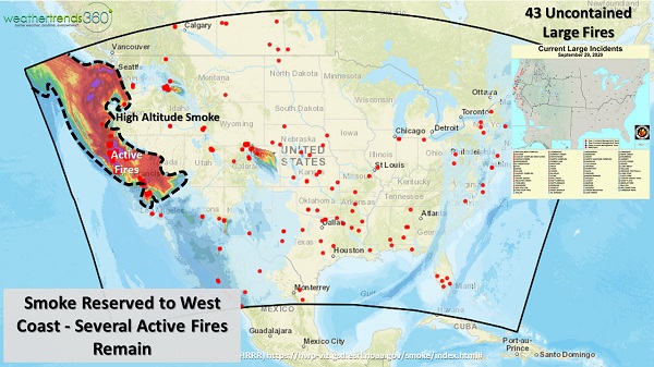
Meanwhile, it's not feeling very autumnal in the West with warm and dry conditions creating a favorable environment for wildfires through the middle of this week. There continue to be 43 uncontained large fires in the West.
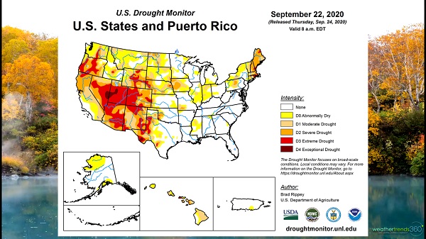
This will be one of the warmest and driest ends to September/beginnings of October in 30 years on the West Coast and a huge change from last year which was one of the coldest in 30 years. Unfortunately, we do not see any substantial precipitation in the forecast for the West Coast as we head into October.
Although we're not seeing the smoky skies here in the East like we did the past couple of weeks, we are seeing some color changes in our skyline as fall foliage is off to an early and brilliant start. Recent dry and cool autumn weather will contribute to a brilliant display this year with places like the Adirondacks already peaking and portions of the higher elevations in the Poconos starting to see some brilliant displays of color. We could certainly use a "bright" spot this year!

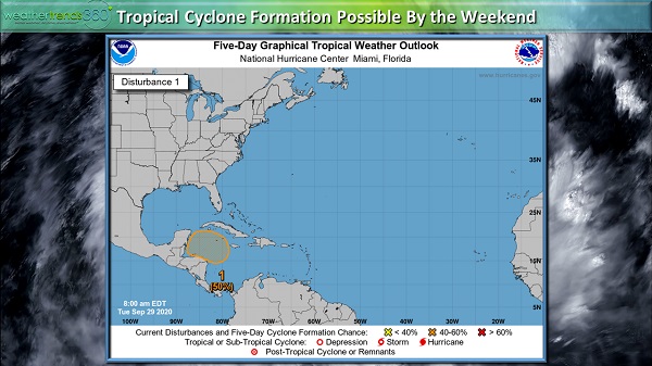
We're currently enjoying a bit of a reprieve in tropical activity in the Atlantic Basin here at the end of September after weeks of nonstop activity. But, the reprieve may be short-lived as we're already watching an area of low pressure in the Caribbean Sea which may develop into a tropical cyclone. The National Hurricane Center currently gives the system 50% chance of development in the next 5 days. There is a fair amount of uncertainty as to the eventual track of the storm with a couple scenarios possible. The storm may head towards Mexico, in which case, it would be a weaker tropical depression or storm. However, the system could wander into the southeast Gulf of Mexico with the potential to strengthen into a hurricane. We'll continue to monitor the progression of this disturbance over the next several days.
We hope you enjoy all the bounties that fall brings, and don't forget to follow us on social media for frequent updates: Facebook, Twitter, YouTube, Pinterest, and LinkedIn.
A cold front moving through the East coast today (Tuesday, September 29th) will bring some much needed rain to New England where drought has been expanding recently. A second cold front will usher in freezing temperatures across the Upper Midwest, Great Lakes and perhaps into the interior New England by the upcoming weekend. It's with this second front that we could see some snow showers develop across parts of the northern Great Lakes and Upper Midwest, although nothing substantial is expected.
Meanwhile, it's not feeling very autumnal in the West with warm and dry conditions creating a favorable environment for wildfires through the middle of this week. There continue to be 43 uncontained large fires in the West.
This will be one of the warmest and driest ends to September/beginnings of October in 30 years on the West Coast and a huge change from last year which was one of the coldest in 30 years. Unfortunately, we do not see any substantial precipitation in the forecast for the West Coast as we head into October.
Although we're not seeing the smoky skies here in the East like we did the past couple of weeks, we are seeing some color changes in our skyline as fall foliage is off to an early and brilliant start. Recent dry and cool autumn weather will contribute to a brilliant display this year with places like the Adirondacks already peaking and portions of the higher elevations in the Poconos starting to see some brilliant displays of color. We could certainly use a "bright" spot this year!
We're currently enjoying a bit of a reprieve in tropical activity in the Atlantic Basin here at the end of September after weeks of nonstop activity. But, the reprieve may be short-lived as we're already watching an area of low pressure in the Caribbean Sea which may develop into a tropical cyclone. The National Hurricane Center currently gives the system 50% chance of development in the next 5 days. There is a fair amount of uncertainty as to the eventual track of the storm with a couple scenarios possible. The storm may head towards Mexico, in which case, it would be a weaker tropical depression or storm. However, the system could wander into the southeast Gulf of Mexico with the potential to strengthen into a hurricane. We'll continue to monitor the progression of this disturbance over the next several days.
We hope you enjoy all the bounties that fall brings, and don't forget to follow us on social media for frequent updates: Facebook, Twitter, YouTube, Pinterest, and LinkedIn.