2016 El Niño Ties Previous Record
Scientific Meteorology
Heavy rain, snow, strong winds and
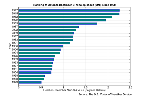
. earthquakes!! Oh My! That's what you're dealing with today in the Golden State! The current strong El Nino no doubt has a hand in influencing this weather pattern in the West and be prepared for more of the same in the coming days and weeks, see our early warning about this in our El Nino video issued last Summer. Speaking of El Nino, data just released from the National Weather service confirms that the current El Nino has tied the 1997/1998 event as the strongest on record! The chart below shows the Oceanic Nino Index (ONI), a measure of Nino events, and the ranking of the strongest El Ninos since 1950 with 1997 and 2015 at the top of the ranks.
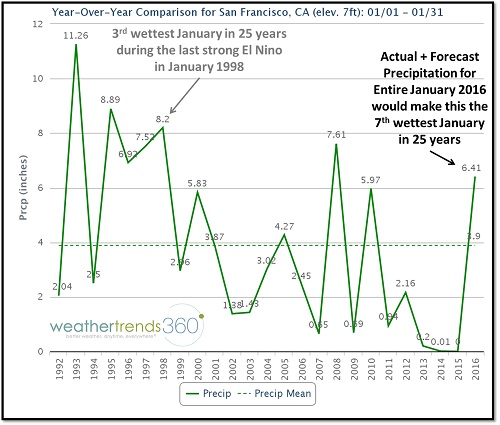
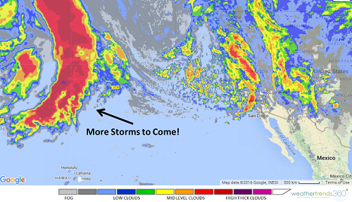
The first of several larger storms has moved in across California today bringing a multitude of hazardous weather to California. Heavy rainfall of up to an inch per hour is forecast with some thunderstorms in southern California while areas near San Francisco have already reported over a half foot of rain! Los Angeles has set a new daily rainfall record already today with 1.42'' and still falling, so already this is the wettest day since mid-September 2015 and the 2nd wettest day of the past 365+ days. To give you more context on just how heavy the rain is, the 1.38'' seen in San Francisco over the past 24 hours is twice as much rain than all of January 2013, 2014, and 2015 COMBINED! (Note, as seen in the chart below, the last very strong El Nino in 1998 also produced above normal rainfall in the San Francisco area).
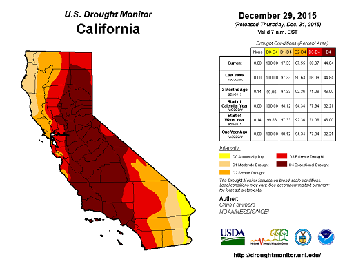
There's no doubt the rain is needed in California as drought conditions still exist across the entire state as shown in the drought map below, however, all of the rain coming at once is bad news. Flash flooding and landslides near recent burn areas are a particularly dangerous threat in addition to falling trees due to wet ground and high winds, and coastal flooding.
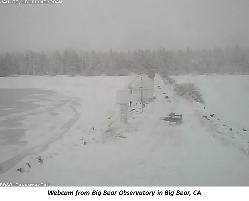
While the valleys are being drenched in rain, the mountains are being socked in with snow. Areas above 6,000 feet will receive several feet of snow, good news for ski resorts that had a dismal season last year. As colder air arrives the snow levels will drop to 5,000 feet and possibly even 4,000 feet tonight through Friday. The webcam image below is from Big Bear Observatory which is approximately 6,700 feet in elevation.
 A respite arrives on Friday and into Saturday morning for California, but then another weather system moves onshore later Saturday and into Sunday with more threats of valley rain and mountain snow. Yet another storm is forecast to move into the state by mid-next week so keep the umbrellas and galoshes handy, and the snow shovels and skis for you mountain folks! In fact there could be as many as half a dozen disturbances impacting the West Coast over the next 2 weeks!
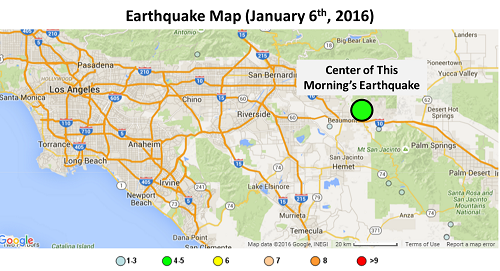
 If all of these weather hazards weren't enough, a 4.4 magnitude earthquake, as measured by the USGS, centered about 85 miles east of Los Angeles shook the region this morning. Fortunately though it appears as if no damage or injury was caused by the temblor. Earthquake maps are available in the interactive mapping section of www.wt360.com
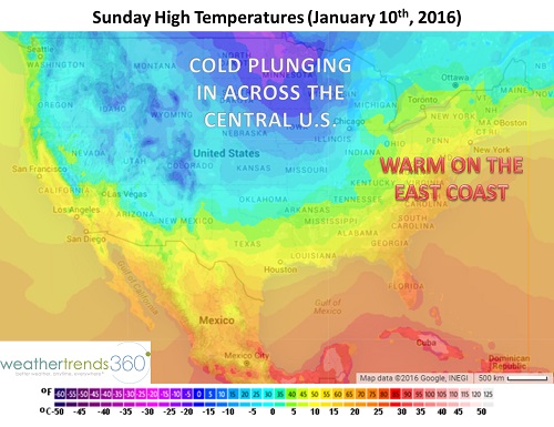
 For those of us shaking in our boots in the East, don't worry we have a warm-up on the way. Above normal temperatures return in time for the weekend with daily high temperatures over 10F above normal in the 50s in the major Northeast cities, but it will be a soggy one (mostly rain, sorry snow bunnies!). Any wintry precipitation would be reserved to interior and higher elevations of northern New England. But alas, this storm will usher in the next push of cold, Arctic air which arrives early next week and will already be diving in across the Central U.S. over the weekend. Snow mongers are already drooling over the latest forecast models as they signal the first accumulating snowfall of the season for most of the major Northeast cities from Baltimore to Boston, but the devil is in the details and those will change many times before next week. In fact, the model runs from earlier in the day have this same storm 1,000 miles off the East Coast, so don't get overly excited about snow just yet. Stay tuned!
. earthquakes!! Oh My! That's what you're dealing with today in the Golden State! The current strong El Nino no doubt has a hand in influencing this weather pattern in the West and be prepared for more of the same in the coming days and weeks, see our early warning about this in our El Nino video issued last Summer. Speaking of El Nino, data just released from the National Weather service confirms that the current El Nino has tied the 1997/1998 event as the strongest on record! The chart below shows the Oceanic Nino Index (ONI), a measure of Nino events, and the ranking of the strongest El Ninos since 1950 with 1997 and 2015 at the top of the ranks.
The first of several larger storms has moved in across California today bringing a multitude of hazardous weather to California. Heavy rainfall of up to an inch per hour is forecast with some thunderstorms in southern California while areas near San Francisco have already reported over a half foot of rain! Los Angeles has set a new daily rainfall record already today with 1.42'' and still falling, so already this is the wettest day since mid-September 2015 and the 2nd wettest day of the past 365+ days. To give you more context on just how heavy the rain is, the 1.38'' seen in San Francisco over the past 24 hours is twice as much rain than all of January 2013, 2014, and 2015 COMBINED! (Note, as seen in the chart below, the last very strong El Nino in 1998 also produced above normal rainfall in the San Francisco area).

There's no doubt the rain is needed in California as drought conditions still exist across the entire state as shown in the drought map below, however, all of the rain coming at once is bad news. Flash flooding and landslides near recent burn areas are a particularly dangerous threat in addition to falling trees due to wet ground and high winds, and coastal flooding.

While the valleys are being drenched in rain, the mountains are being socked in with snow. Areas above 6,000 feet will receive several feet of snow, good news for ski resorts that had a dismal season last year. As colder air arrives the snow levels will drop to 5,000 feet and possibly even 4,000 feet tonight through Friday. The webcam image below is from Big Bear Observatory which is approximately 6,700 feet in elevation.
A respite arrives on Friday and into Saturday morning for California, but then another weather system moves onshore later Saturday and into Sunday with more threats of valley rain and mountain snow. Yet another storm is forecast to move into the state by mid-next week so keep the umbrellas and galoshes handy, and the snow shovels and skis for you mountain folks! In fact there could be as many as half a dozen disturbances impacting the West Coast over the next 2 weeks!If all of these weather hazards weren't enough, a 4.4 magnitude earthquake, as measured by the USGS, centered about 85 miles east of Los Angeles shook the region this morning. Fortunately though it appears as if no damage or injury was caused by the temblor. Earthquake maps are available in the interactive mapping section of www.wt360.comFor those of us shaking in our boots in the East, don't worry we have a warm-up on the way. Above normal temperatures return in time for the weekend with daily high temperatures over 10F above normal in the 50s in the major Northeast cities, but it will be a soggy one (mostly rain, sorry snow bunnies!). Any wintry precipitation would be reserved to interior and higher elevations of northern New England. But alas, this storm will usher in the next push of cold, Arctic air which arrives early next week and will already be diving in across the Central U.S. over the weekend. Snow mongers are already drooling over the latest forecast models as they signal the first accumulating snowfall of the season for most of the major Northeast cities from Baltimore to Boston, but the devil is in the details and those will change many times before next week. In fact, the model runs from earlier in the day have this same storm 1,000 miles off the East Coast, so don't get overly excited about snow just yet. Stay tuned!