Hurricane Harvey Heading Towards Texas
Here's an update on Harvey which rapidly developed into a hurricane yesterday afternoon and as of late this morning was a category 2 hurricane with maximum sustained winds up to 110 mph. Hurricane Harvey will likely strengthen further and is expected to reach major hurricane status (category 3+) today and forecasts now project that he will make landfall as a major hurricane within 24 hours near Corpus Christi. If this happens, this will be the first major hurricane to make landfall in the U.S. since Hurricane Wilma in 2005 and this will likely be the first hurricane with winds greater than 125 mph to impact Texas since Hurricane Celia in 1970. Preparations should be complete or near completion along the coastal bend of Texas as the outer bands of Harvey have already started coming onshore. This will be a prolonged event for Texas and we cannot stress enough how critical the situation is, the long-duration of heavy rainfall will put significant stress on food supply, gasoline, and energy as this area is responsible for one-third of the nation's refining capacity; if you live in the affected area please take the advice of local emergency management.
As of 11 am (EDT) Harvey was located about 115 miles southeast of Corpus Christi, TX with maximum sustained winds of 110 mph and pressure down to an impressive 947 mb. The storm continues to head northwest at about 10 mph. Harvey will continue on a slow approach to Texas before making landfall sometime late tonight or early Saturday morning near Corpus Christi. Harvey is on the verge of major hurricane status and will likely attain major status (which is a category 3 storm or higher) at any time now. Harvey will retain major status up until landfall with some gradual weakening thereafter. Unfortunately, this storm will be slow to weaken as much of Harvey's circulation will remain over water.
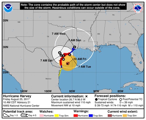
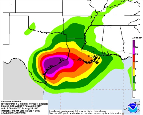
While model guidance is in good agreement as to the track up through landfall, thereafter there is divergence in where Harvey heads. The primary thinking is that Harvey will meander over Texas for the next several days and could even move back into the Gulf of Mexico at some point. If Harvey reemerges in the Gulf, he could regain some strength and make another landfall somewhere in Texas or maybe even Louisiana. Regardless, it is likely that Harvey will be near or over Texas for the next 5 days as a hurricane or tropical storm. This is an extremely critical situation for residents from Brownsville to Houston. Harvey will bring widespread precipitation of +15'' and we wouldn't be surprised to see spots of 2 or even 3 feet of rain in the next week. Flooding WILL occur.
Impacts will include widespread flooding from heavy rain (heaviest rain likely in an area from Corpus Christi to near Houston), storm surge flooding (6-12' storm surge from Corpus Christi to Port O'Connor), and wind damage. Some areas, especially in and around Corpus Chrisiti could become uninhabitable for an extended period of time. Power outages will occur, and roads will become impassable. Retailers have hopefully boarded up facilities in the path of this storm; brace for extended period of store closures in this area.
The hardest hit area currently looks to be the Corpus Christi area. Other areas that will be impacted by Harvey include:
-Houston
-Galveston
-Brownsville
-San Antonio
-Austin
Flooding is the primary concern with Harvey as incredible amounts of rain are forecast to fall. For radar and local forecasts, please log-in to www.wt360.com . Up-to-date details on Hurricane Harvey can also be accessed on www.nhc.noaa.gov.
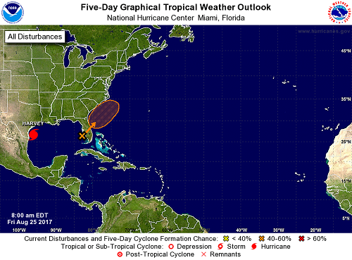
We're also continuing to watch a tropical disturbance located near South Florida which is producing numerous showers and thunderstorms for central and southern Florida. While development of this system is not likely in the near-term, we will have to watch for possible development late in the weekend or early next week. For now, however, the main concern with this feature will be flash flooding in central and southern Florida.