Hurricane Michael Tracks Toward Florida
Breaking Weather Events
Hurricane Michael continues on a track that will bring the storm inland somewhere near Panama City, FL tomorrow. There is growing confidence that Michael will be a major hurricane at landfall (category 3 or higher on the Saffir-Simpson scale). Regardless of intensification, Michael is poised to bring significant storm surge and freshwater flooding across the Florida panhandle and inland across Georgia and the Carolinas and possibly into the Delmarva. Evacuations are underway across the Florida panhandle as conditions will begin to deteriorate tonight.
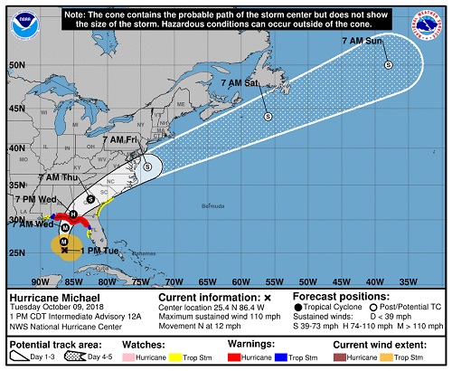
This is a dangerous storm, please heed all advice from local emergency management if you are in Hurricane Michael's track path.
The remnants of Michael will be whisked quickly out to sea on Friday as a cold front barrels through bringing noticeably colder weather across the Midwest and Northeast.
IMPACTS
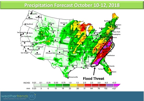
- Flooding along the panhandle of Florida to the western Big Bend area of Florida with the worst occurring tomorrow (Wednesday); some structures will be completely inundated
- Strong winds bringing down trees and causing structure damage
- Several inches of rain from the Florida panhandle to the Delmarva could cause flooding, especially along recently swollen rivers in the Carolinas
- Strong, tropical storm-force winds are likely to be felt all the way to the Carolinas as Michael arrives Thursday morning
WHERE
Hurricane Conditions Wednesday-Thursday (Storm Surge/Flooding, Destructive Wind Threat)
- Panama City, FL
- Tallahassee, FL
- Pensacola, FL
- Albany, GA
Tropical Storm Conditions Thursday-Friday (Flooding, Strong Wind Threat)
- Valdosta, GA
- Savannah, GA
- Charleston, SC
- Columbia, SC
- Charlotte, NC
- Wilmington, NC
- Virginia Beach, VA
- The Delmarva
This is a dangerous storm, please heed all advice from local emergency management if you are in Hurricane Michael's track path.
The remnants of Michael will be whisked quickly out to sea on Friday as a cold front barrels through bringing noticeably colder weather across the Midwest and Northeast.