2016 Flooding in South Louisiana
Did You Know?
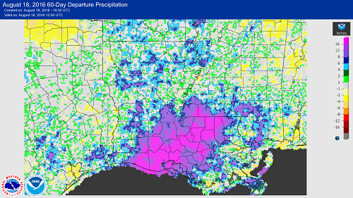
Southern Louisiana is by no means a stranger to flooding given its proximity to the Gulf of Mexico, low elevations, and multiple waterways. Over the past century, the area has been subjected to numerous flood events, including the historic flooding caused by last week's record-breaking rainfall. The heaviest rain totals clocked in at over 2 feet which fell in less than a 3 day period, that's an extraordinary amount even for a place used to tropical downpours. All of this rainfall came from a weather system that wasn't even a named tropical cyclone, however, tropical-sourced moisture was 1 ingredient of in the heavy downpours. Although no 2 weather systems or events are exactly the same, there are definitely many similarities that can be drawn between the August 2016 flood and the flooding of April 1983. The same area (Baton Rouge) saw a significant flooding event where rainfall that wasn't related to a tropical storm of hurricane brought heavy rainfall and devastating flooding to an already saturated southern Louisiana in 1983, and coincidentally, both floods occurred following very strong El Ninos (1982/1983 and 2015/2016). The map of Louisiana below shows the area impacted by the recent flooding has seen a departure from normal rainfall of over 16'' in the past 60 days!
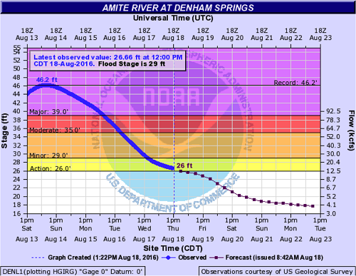
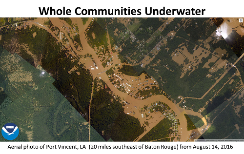
Like last week's flood event, the 1983 flooding featured nearly 20'' of rain falling in the span of several days over southern Louisiana with some of the heaviest amounts in the Baton Rouge area. The governor of Louisiana at the time, David C. Treen, reported that the worst damage was in Denham Springs, which is the same area where we're seeing some of the worst devastation this year. The scene was similar back in 1983 with travel difficult as many roadways were covered in water and city officials declared this as "some of the worst flooding on record". In fact, the Amite levee system built following the 1983 flood was built to withstand a similar event, but heavy development and a few extra inches of rain seems to have made all the difference during this year's event. Below is the river gauge from the Amite River at Denham Springs where the river crested almost 5' above the 1983 record event. Several levees in this system were overtopped in the most recent rain event.
Many of the news headlines and reports from the 1983 flooding are eerily similar to what we've been hearing out of Louisiana the past week. "Areas that never flooded before were flooding", "Worst flooding on record", "Caskets floating amidst flood waters", etc
In fact, several articles written just 3 years ago during the 30th anniversary of the flooding of 1983 in Louisiana noted that this kind of flooding would happen again, and would likely be more severe due to land development (more buildings and roads leads to greater runoff). Unfortunately, those predictions became reality last week.
Increased land development pretty much ensures that major flooding will occur again and again and is likely to become worse. Even human attempts to mitigate flooding have often proved to be lacking or actually makes the problem worse. Levees constructed for flood protection can actually, in some cases, make problems worse over time. Increasing numbers of homes along rivers and near oceans inherently increases the number of people and property at risk due to natural disasters. Unfortunately, we will see scenarios similar to what is currently happening in southern Louisiana again and again. For now, there is no miracle solution to the flood problem in Louisiana but there are lessons to be learned from history.