Significant Snow in Northeast Cities for 2017
Breaking Weather Events
Don't let the spring-like temperatures in the Northeast today fool you, winter returns with vengeance tonight! Following a day of temperatures near record warmth with highs in the 50s and 60s across the major Northeast cities, a winter storm will come racing in late tonight and early tomorrow morning spreading significant snow across the region. In fact, for most of the major Northeast cities, this will likely be the most significant snowfall of the season so far. Temperatures will reach their highs early in the day and then fall throughout the rest of the day as the storm approaches.
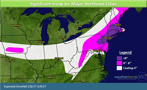
The storm will race through the Plains and Midwest today with generally a coating to 4'' of snow for most of the region. Then as the storm reaches the Northeast it will intensify and move just off the Mid-Atlantic coast. The storm will then track northeastward, parallel to the coast. As with any storm of this nature, a difference in the track just 50 miles east or west will dramatically alter how much snow falls and where it falls. However, the computer forecast models have come into fairly good agreement with this system so confidence is high for a significant event. Precipitation may start out as rain, especially east of the I-95 corridor, but will changeover to snow as colder air rushes in. Widespread 4-8'' of snow is expected across the eastern parts of the Northeast. Over 8'' of snow is possible from near Allentown, PA northeastward to Boston, MA. There could be localized totals of over a foot of snow in this particular area.
The snow will then spread into the rest of the Northeast very early Thursday morning. Intense snowfall rates of 1-2'' per hour are expected late tonight and early tomorrow morning causing major impacts to the Thursday morning commute. Snow may be slow to accumulate on the roads at first due to the warmer temperatures earlier in the day, but as the snow intensifies late tonight and early tomorrow morning roads will become hazardous.
Today will be a day of preparation in the Northeast as many brace for the most snow they've seen since January 2016's blizzard. While this storm will not be anywhere near as severe as the January 2016 storm, this will still be a rather impactful event. The storm will spread across eastern Pennsylvania, New Jersey, and southern New England late tonight and into northern New England early Thursday morning. The snow will be a heavy and wet so there will be a risk of downed trees and power lines which may cause power outages.
Expect significant impacts in the following cities:
• Harrisburg
• Allentown
• Philadelphia
• Scranton
• Newark
• New York City
• Trenton
• Hartford
• Providence
• Boston
• Worcester
• Manchester
Baltimore will be on the edge of the storm with a mixture of rain and snow at the onset of the precipitation which will help to keep overall snowfall totals down.
This winter storm will be a quick mover with precipitation ending by early afternoon for most of the Northeast. Store traffic will be negatively impacted on Thursday but should return to normal by Friday for most.