Star Date 18 January 2019 Friday Update
Captain's Log
18 Jan 2019 Friday:final snow storm update.
14 Jan 2019 Happy Monday! :)
A lot to talk about this week with very cold and snowy weather for the later half of January. CLICK ON IMAGES FOR A LARGER VIEW.
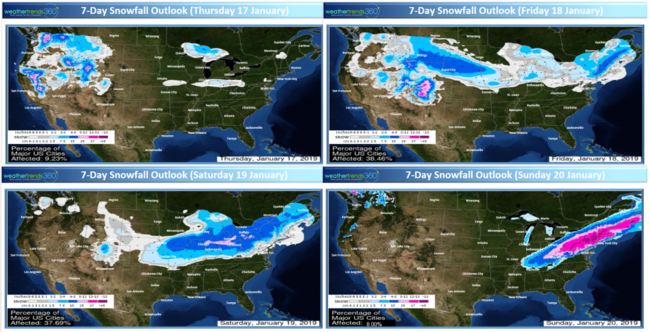
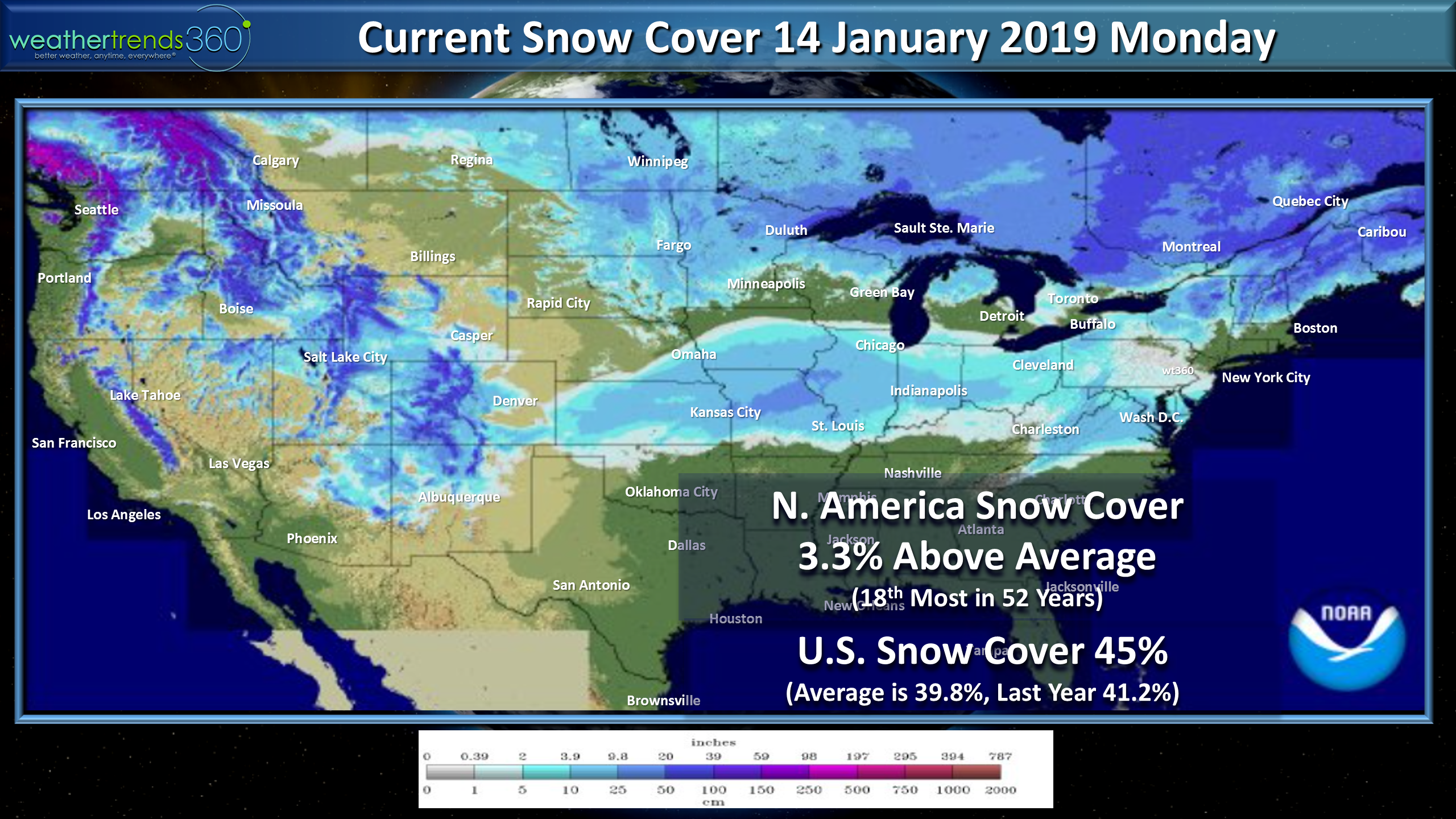
The storm that just went through the Central U.S. and Middle Atlantic has boosted national snow cover to 45%this morning which is a tad above average and above last year. Without any blocking in the Atlantic Ocean the system went straight out to sea which kept the Northeast very cold but dry. May not be so lucky with the next system coming up.

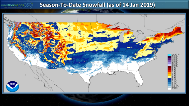
Snowfall season to date across the U.S. has every state except Florida reporting some measurable snow so far this season.
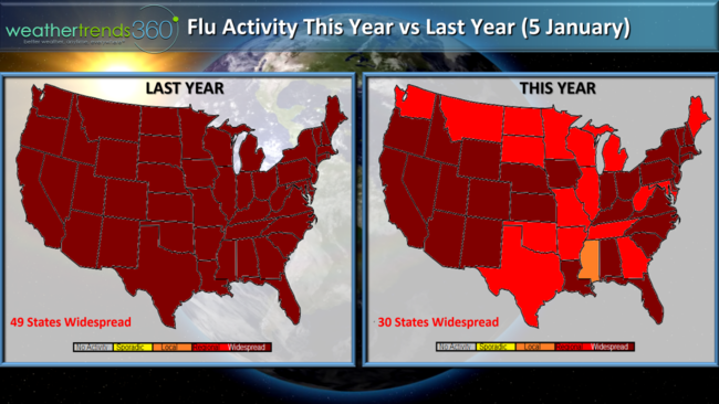
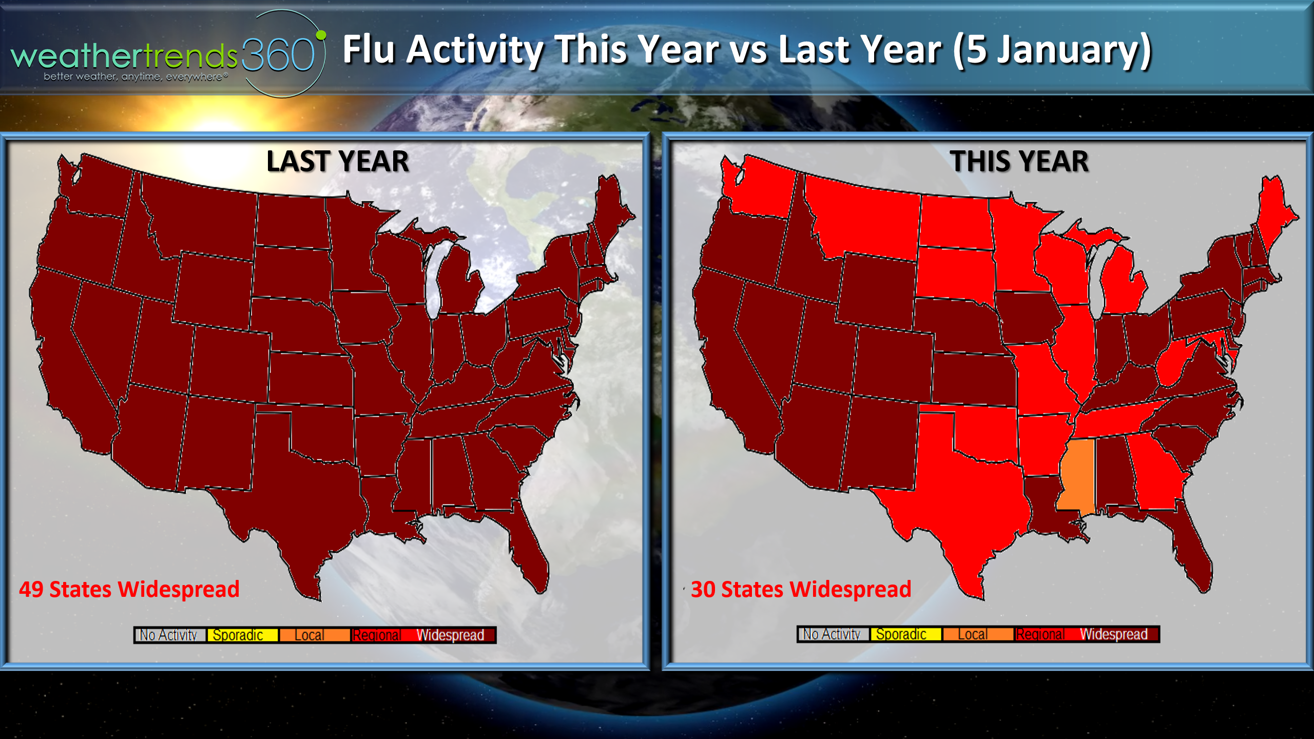
If you're feeling under the weather the flu bug has 30 states with widespread outbreak but this is much less than last year when the U.S. was suffering from one of the worst flu seasons in decades. The strain this year is not as severe as last year.
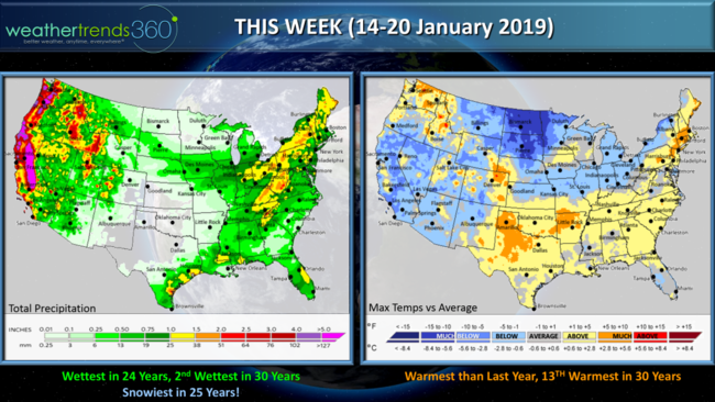
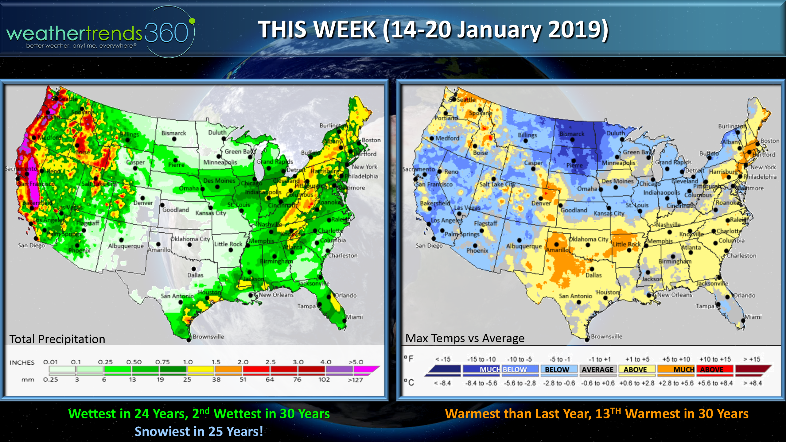
This week (14-21 January) shows another reinforcing shot of cold air invading the northern tier of the U.S. and heading for much of the Eastern half of the country by the weekend. A strong storm system will move across the U.S. Midwest and Northeast late in the week into the weekend. For the U.S. overall, the week is a tad warmer than last year, 13th warmest in 30 years, wettest in 24 years (2nd most in 30 years) with the most snowfall in 25 years!
LUNAR ECLIPSE Sunday 20 January. Probably not visible in the East with the big storm but the rest of North and South America will have a good show for the full lunar eclipse.
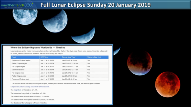
The weekend snowfall outlook will hamper viewing the eclipse in the East.
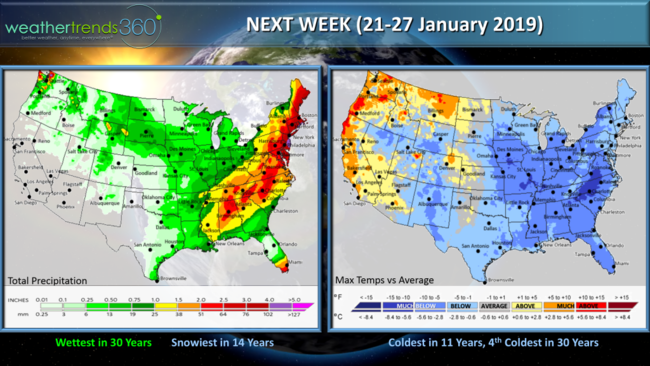
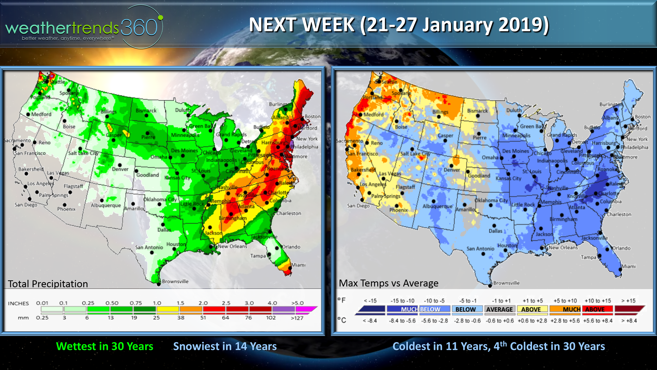
Next week (22-27 January) the Arctic invades the Eastern half of the country making the last full week of January the coldest in 11 years, 4th coldest in 30 years, wettest in 30 years and the most snow in 14 years for the U.S. overall.
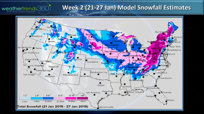
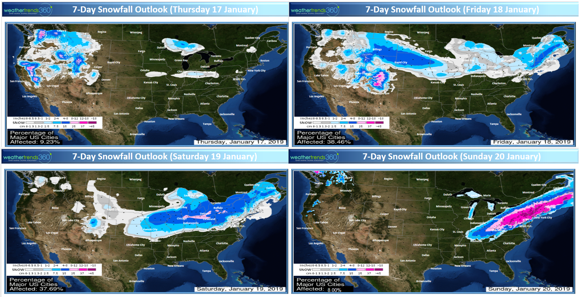
Model snowfall shows more heavy snow potential across the Midwest and Northeast so a stormy pattern is setting up.
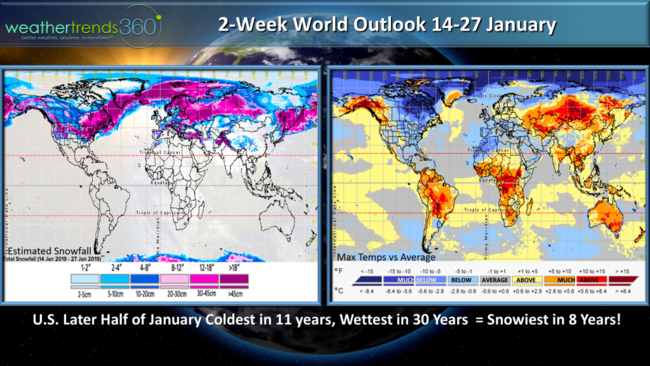
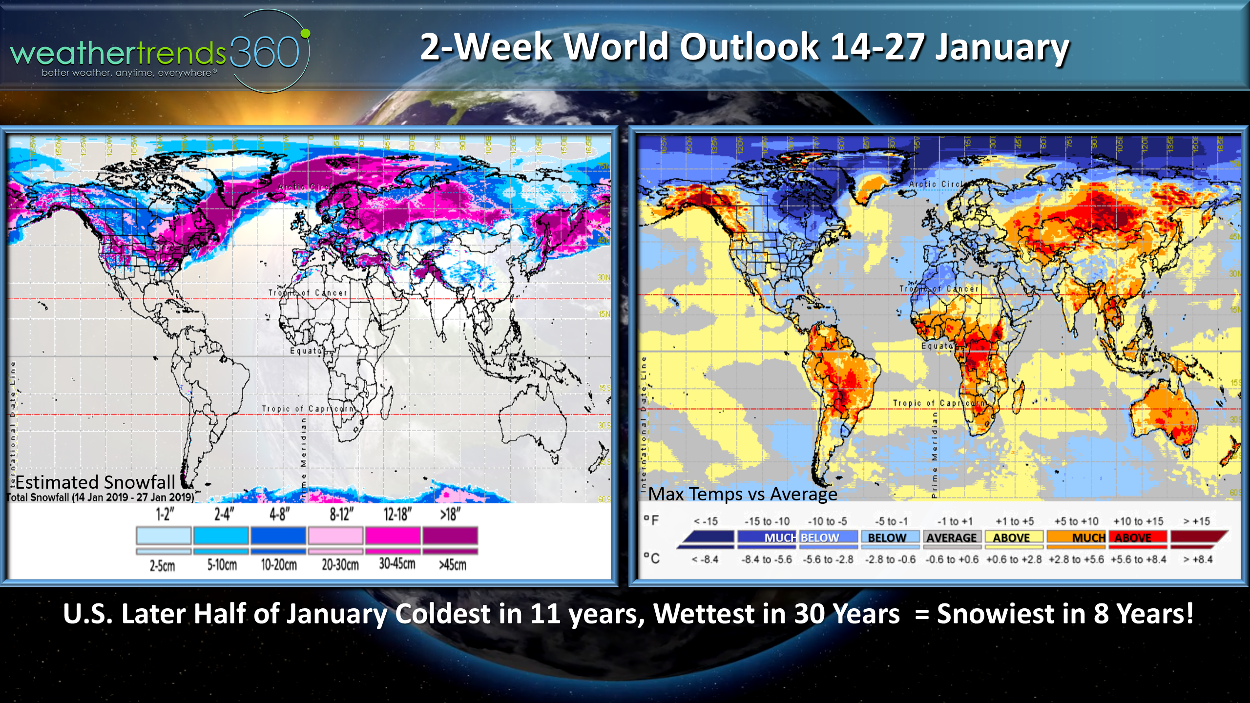
For the later half of January the world outlook shows the cold weather will lock in for Eastern North America, Southern Europe and Northern Africa. The snow looks to be very heavy across the Northern tier of the U.S., East Coast U.S. and Eastern Canada and Eastern Europe. The latter half of January in the U.S. looks to trend the coldest in 11 years, wettest in 30 years and most snow in 8 years...WINTER IS HERE!
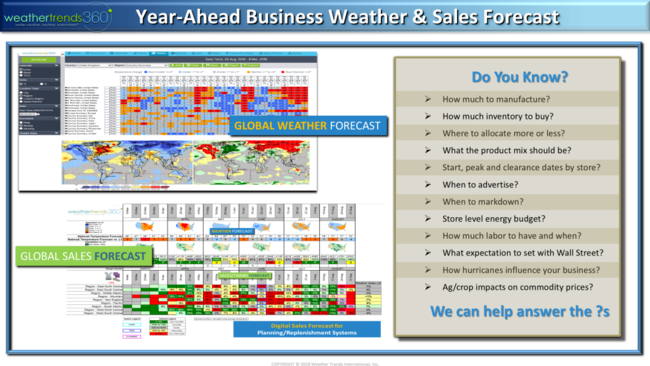
For folks that don't know what we do here at Weather Trends, our core business is a statistical 24 climate cycle approach to predicting temperatures, rainfall and snowfall a year-ahead by week covering every 1 mile on Earth!
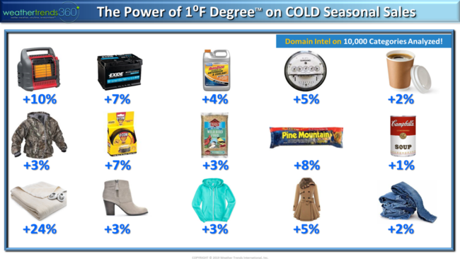
From there we quantify the "Power of 1 Degree"® on seasonal sales to help retailers and suppliers get the right amount of seasonal merchandise in the right spots everywhere in the world. We call it Better Business in any Weather to help Fortune 500 companies to better plan just about every phase of the business a YEAR-AHEAD!
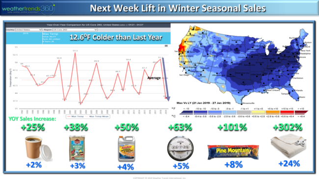
Using next week (22-27 January) as an example, the U.S. will trend a whopping 12.6F colder than last year which will bring a huge surge in Winter seasonal merchandise sales. See map/data above.
Have a great week folks and don't forget to follow us on social media for frequent updates.Facebook,Twitter,YouTube,PinterestandLinkedin
- Captain Kirk out.
14 Jan 2019 Happy Monday! :)
A lot to talk about this week with very cold and snowy weather for the later half of January. CLICK ON IMAGES FOR A LARGER VIEW.
The storm that just went through the Central U.S. and Middle Atlantic has boosted national snow cover to 45%this morning which is a tad above average and above last year. Without any blocking in the Atlantic Ocean the system went straight out to sea which kept the Northeast very cold but dry. May not be so lucky with the next system coming up.
Snowfall season to date across the U.S. has every state except Florida reporting some measurable snow so far this season.

If you're feeling under the weather the flu bug has 30 states with widespread outbreak but this is much less than last year when the U.S. was suffering from one of the worst flu seasons in decades. The strain this year is not as severe as last year.
This week (14-21 January) shows another reinforcing shot of cold air invading the northern tier of the U.S. and heading for much of the Eastern half of the country by the weekend. A strong storm system will move across the U.S. Midwest and Northeast late in the week into the weekend. For the U.S. overall, the week is a tad warmer than last year, 13th warmest in 30 years, wettest in 24 years (2nd most in 30 years) with the most snowfall in 25 years!
LUNAR ECLIPSE Sunday 20 January. Probably not visible in the East with the big storm but the rest of North and South America will have a good show for the full lunar eclipse.
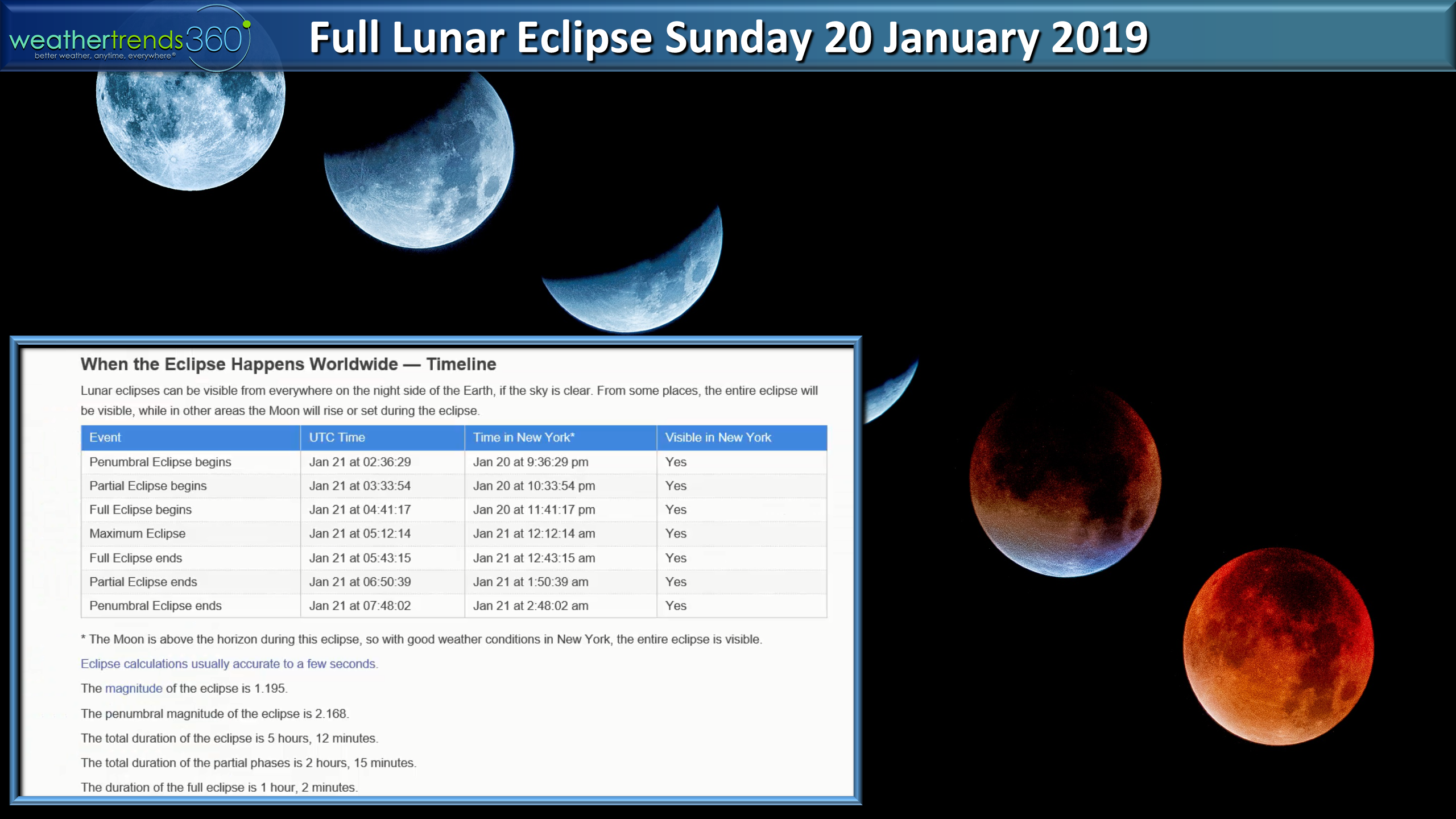
The weekend snowfall outlook will hamper viewing the eclipse in the East.
Next week (22-27 January) the Arctic invades the Eastern half of the country making the last full week of January the coldest in 11 years, 4th coldest in 30 years, wettest in 30 years and the most snow in 14 years for the U.S. overall.
Model snowfall shows more heavy snow potential across the Midwest and Northeast so a stormy pattern is setting up.

For the later half of January the world outlook shows the cold weather will lock in for Eastern North America, Southern Europe and Northern Africa. The snow looks to be very heavy across the Northern tier of the U.S., East Coast U.S. and Eastern Canada and Eastern Europe. The latter half of January in the U.S. looks to trend the coldest in 11 years, wettest in 30 years and most snow in 8 years...WINTER IS HERE!
For folks that don't know what we do here at Weather Trends, our core business is a statistical 24 climate cycle approach to predicting temperatures, rainfall and snowfall a year-ahead by week covering every 1 mile on Earth!

From there we quantify the "Power of 1 Degree"® on seasonal sales to help retailers and suppliers get the right amount of seasonal merchandise in the right spots everywhere in the world. We call it Better Business in any Weather to help Fortune 500 companies to better plan just about every phase of the business a YEAR-AHEAD!

Using next week (22-27 January) as an example, the U.S. will trend a whopping 12.6F colder than last year which will bring a huge surge in Winter seasonal merchandise sales. See map/data above.

Have a great week folks and don't forget to follow us on social media for frequent updates.Facebook,Twitter,YouTube,PinterestandLinkedin
- Captain Kirk out.