22-23 January Nor'easter Update
Breaking Weather Events
Thursday 3pm EST Nor'easter update.
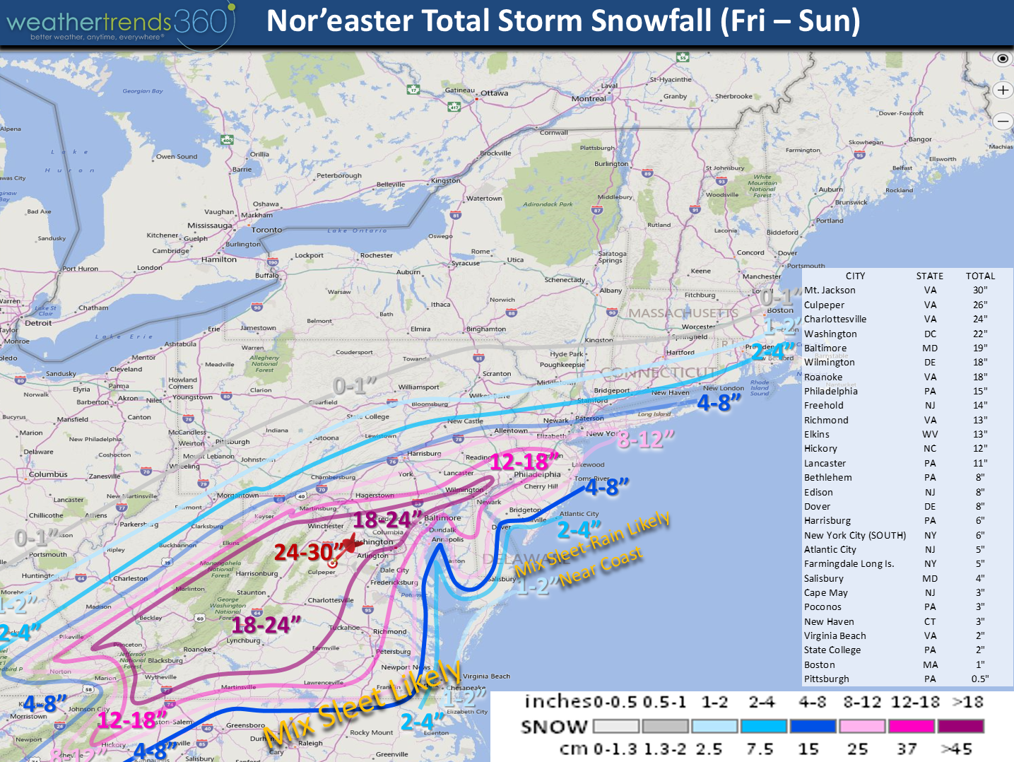
So the latest 12Z (morning models) have not made any sweeping changes from yesterday. The NAM model is the furthest north so that's the only one that brings hope for heavier snow further than forecast here. The U.S. GFS is a tad further north than the European model with the European model the furthest south. The GFS puts the bulls-eye of 24"+ snow totals around Washington D.C. and Baltimore. The Euro has the epic totals a tad to the Southwest in Western and Northwest Virginia.
All models have one heck of a cut off between no snow and heavy snow so this will be important to watch once the storm takes shape as a 50 mile shift in the track can bring huge changes in the fringe areas to the North from Pittsburgh to Boston and the fringe areas to the South from Greensboro NC to Atlantic City NJ. Other differences include the GFS bringing in more warm air aloft which could give many areas a period of sleet. A longer period of sleet cuts down on snow totals. Right now the liquid snow ratios will start off high in the 13 to 1 range as the storm will start off with temps in the low to middle 20s for most of us. These temps could warm up to upper 20s in the middle of the storm by Saturday and that brings snow ratios closer to 10 to 1 (this means that 1" of rain can produce 10" of snow so 13:1 produces more snow with 13" of snow for every 1" of available moisture).
Other factors that will play a role here will include a dry slot and that can have one area getting 15" while 50 miles away gets 6". Elevation in western Virginia, Western Maryland will enhance snowfall totals so that's why we have our bulls-eye more in line with Euro. The ocean temperatures 100 miles off Virginia Beach are in the 60s and 100 miles off New Jersey they're in the 50s. Right along the immediate coast the ocean temps are 48F near Virginia Beach, 46 Cape May and 44 in the Chesapeake Bay and Delaware Bay. With a more easterly wind as the Nor'easter cranks up Saturday this milder air will hold down snow totals within 25-50 miles of the coast. Major coastal flooding is possible as we have a full moon on Saturday with the high tides generally around 7am Saturday morning, 7pm Saturday night and 7:30am Sunday morning. Winds right at the shore will be strong 30mph gusting to maybe 60mph.
While the daily snow maps in the video may show a bit more snowfall, this map below reflects our final thoughts - a blend between the U.S. GFS and Euro factoring in the comments above. Again, a 50 to 100 mile shift is something no model can predict even 6 hours out and that would have a big impact on the north and south fringe areas as will the inevitable dry slot and potential sleet.
For the track and start, end times...watch the video above and you can stop that at your leisure to micro-analyze if needed! :) We will keep you up to date with frequent storm updates on facebook.

- Capt Kirk and the entire weathertrends360 team IN monitoring the storm for YOU! :)
So the latest 12Z (morning models) have not made any sweeping changes from yesterday. The NAM model is the furthest north so that's the only one that brings hope for heavier snow further than forecast here. The U.S. GFS is a tad further north than the European model with the European model the furthest south. The GFS puts the bulls-eye of 24"+ snow totals around Washington D.C. and Baltimore. The Euro has the epic totals a tad to the Southwest in Western and Northwest Virginia.
All models have one heck of a cut off between no snow and heavy snow so this will be important to watch once the storm takes shape as a 50 mile shift in the track can bring huge changes in the fringe areas to the North from Pittsburgh to Boston and the fringe areas to the South from Greensboro NC to Atlantic City NJ. Other differences include the GFS bringing in more warm air aloft which could give many areas a period of sleet. A longer period of sleet cuts down on snow totals. Right now the liquid snow ratios will start off high in the 13 to 1 range as the storm will start off with temps in the low to middle 20s for most of us. These temps could warm up to upper 20s in the middle of the storm by Saturday and that brings snow ratios closer to 10 to 1 (this means that 1" of rain can produce 10" of snow so 13:1 produces more snow with 13" of snow for every 1" of available moisture).
Other factors that will play a role here will include a dry slot and that can have one area getting 15" while 50 miles away gets 6". Elevation in western Virginia, Western Maryland will enhance snowfall totals so that's why we have our bulls-eye more in line with Euro. The ocean temperatures 100 miles off Virginia Beach are in the 60s and 100 miles off New Jersey they're in the 50s. Right along the immediate coast the ocean temps are 48F near Virginia Beach, 46 Cape May and 44 in the Chesapeake Bay and Delaware Bay. With a more easterly wind as the Nor'easter cranks up Saturday this milder air will hold down snow totals within 25-50 miles of the coast. Major coastal flooding is possible as we have a full moon on Saturday with the high tides generally around 7am Saturday morning, 7pm Saturday night and 7:30am Sunday morning. Winds right at the shore will be strong 30mph gusting to maybe 60mph.
While the daily snow maps in the video may show a bit more snowfall, this map below reflects our final thoughts - a blend between the U.S. GFS and Euro factoring in the comments above. Again, a 50 to 100 mile shift is something no model can predict even 6 hours out and that would have a big impact on the north and south fringe areas as will the inevitable dry slot and potential sleet.
For the track and start, end times...watch the video above and you can stop that at your leisure to micro-analyze if needed! :) We will keep you up to date with frequent storm updates on facebook.
- Capt Kirk and the entire weathertrends360 team IN monitoring the storm for YOU! :)