Captain's Log 13 Apr '24 Warmer & Drier Surge in Spring Merchandise
Captain's Log
13 April '24: Happy Saturday! :)
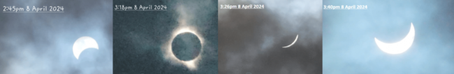
In today's video update we start with a couple minutes of highlights of the Total Solar Eclipse as seen from Niagara Falls, Canada. There were a lot of clouds, but they broke up just in time to catch totality. CLICK ON IMAGES FOR A LARGER VIEW.
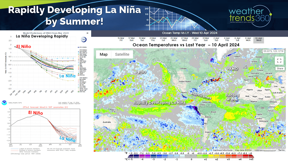
Zero doubt we're headed for a moderate to strong La Niña by Summer as the Equatorial Pacific continues to cool rapidly.
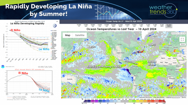
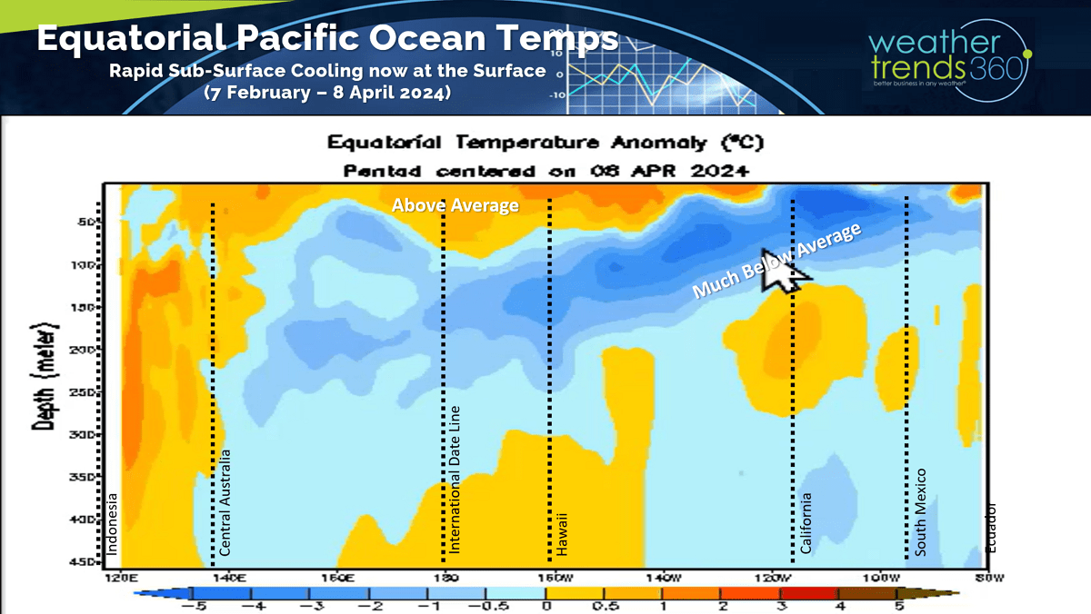
The subsurface water temperatures are well below average and that colder water is percolating to the surface. That will begin to alter the World weather patterns in the months ahead.

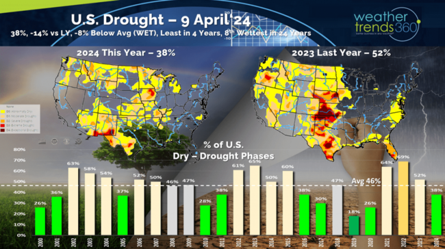
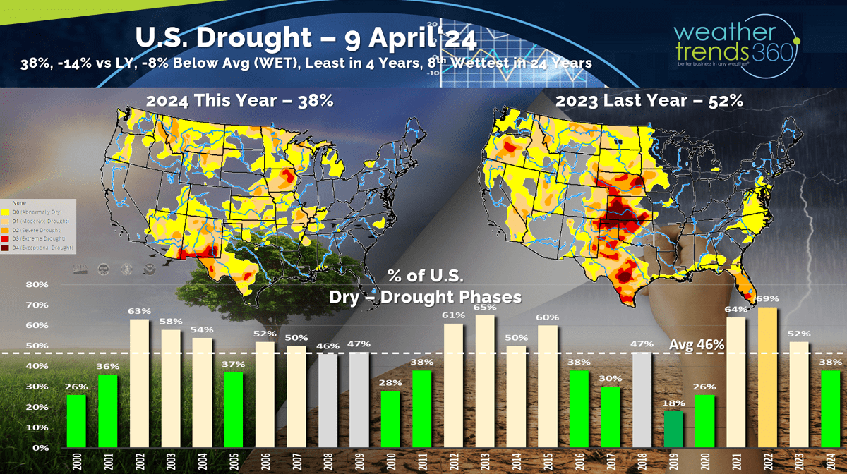
Drought is quickly being erased for most of the U.S. with only 38% of the country in dry to drought phases, least in 4 years and well below the average of 46% and last year at 52%. The peak drought phase was in November 2022 at 82% of the country in dry to drought phases due in part to the 3-year La Niña cycle.
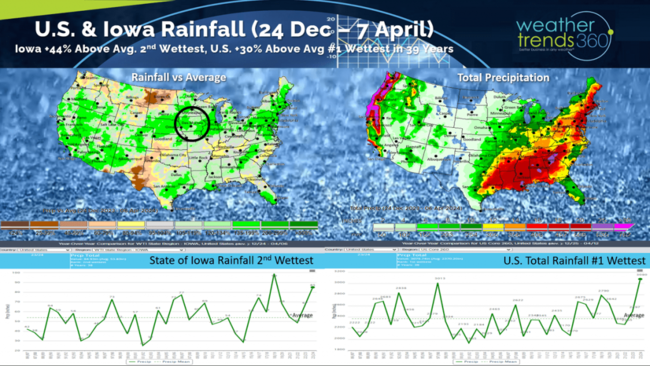
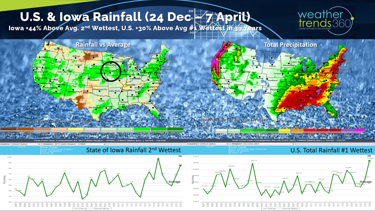
Be careful with drought maps as they are lagging indicators. Iowa as an example still shows extreme drought but that's not accurate as the past 4.5 months have been the wettest in 5 years and 2nd wettest in 39 years with much above average rainfall. The U.S. overall has been the #1 wettest since Christmas, the gift (RAIN) that keeps on giving.
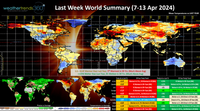
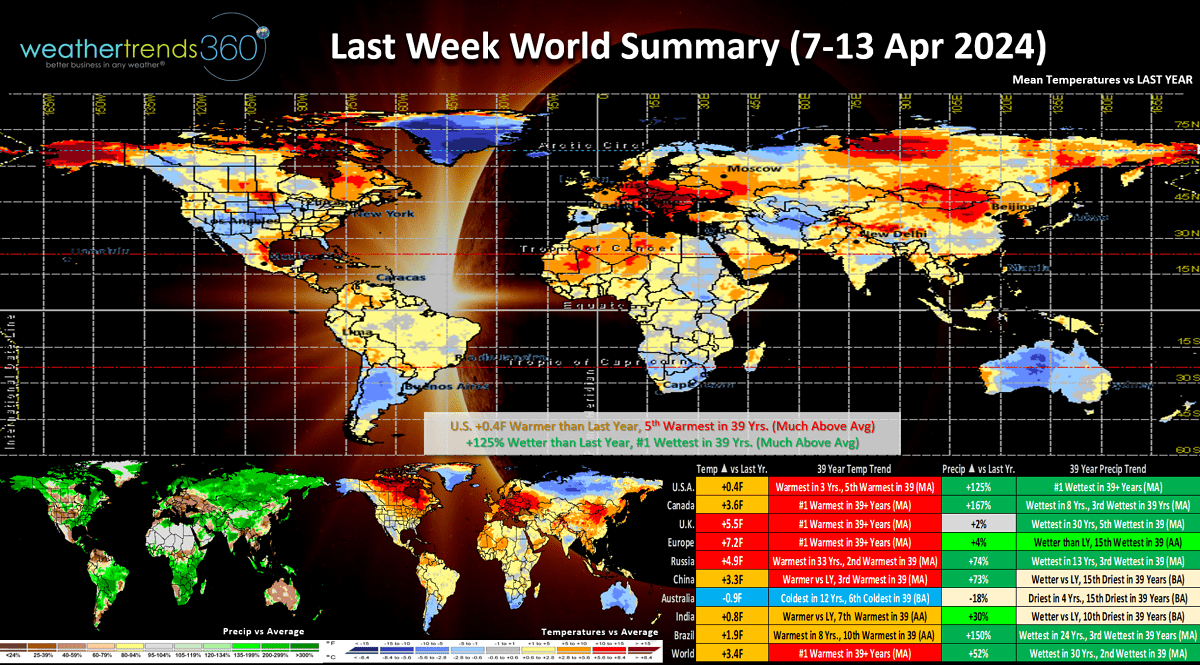
Last week (7-13 April) across the World shows the U.S. trending +0.4F warmer than last year and 5th warmest of the past 39 years. Rainfall was up +125% making it the #1 wettest 2nd week of April in over 39 years. Wet weather is a drag on store traffic, but the solar eclipse may have been a surge from TX to ME with millions flocking to the region. Most of the World was on the warm and very wet side due in large part to all the water vapor pumped into the atmosphere from El Nino and the Tonga Volcano a couple years ago. That oceanic volcanic water vapor will be in the atmosphere for several years which acts as a strong greenhouse gas.
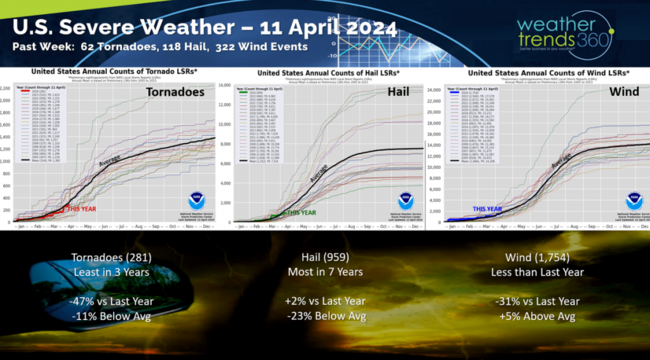
Severe weather saw a bigger uptick last week with 62 tornadoes, 118 hail events and 322 wind events. Tornado counts are still the least in 3 years while Hail is the most in 7 years and wind down from last year but still above average. The severe weather threats will continue to ramp up April - June with a very active and destructive season.
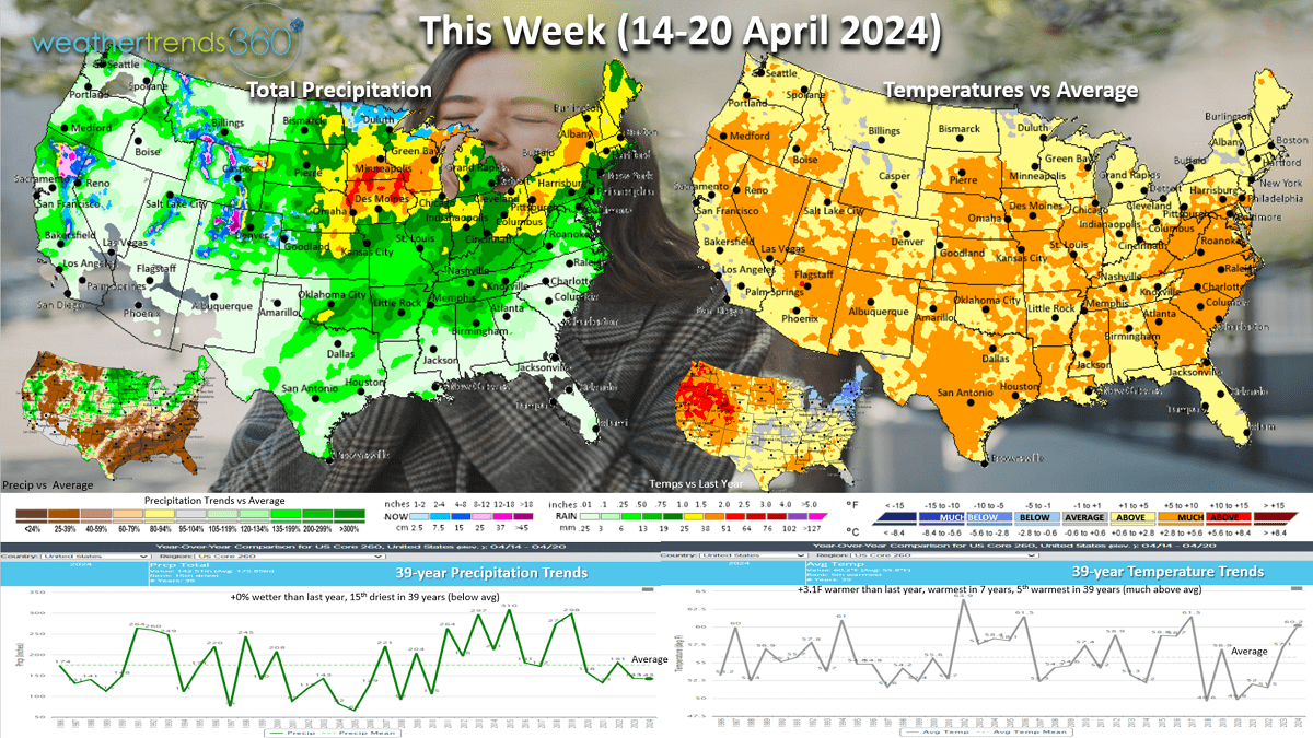
This week (14-20 April) shows coast-to-coast Spring warmth with the U.S. trending +3.1F warmer than last year, warmest in 7 years and 5th warmest of the past 39 years. The Northeast is the one region trending cooler than last year. Rainfall is flat and 15th driest in 39 years with the heaviest rain in the Midwest and interior Northeast. Warm and Dry weather will bring near peak allergy and asthma suffering conditions for much of the country.

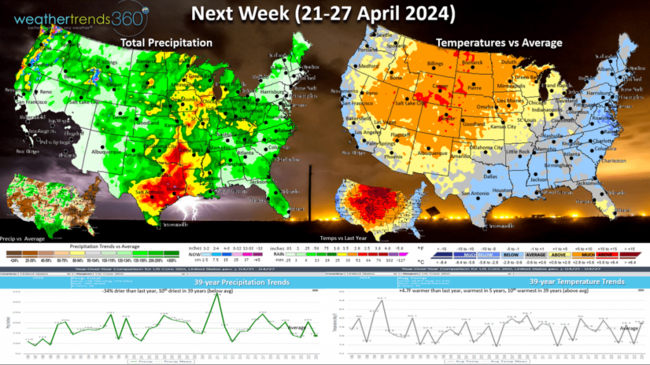
Next week (21-27 April) shows much cooler conditions for the East Coast which will dampen demand for Spring merchandise. The U.S. overall still trends +4.7F warmer than last year, warmest in 5 years and 10th warmest of the past 39 years. While rainfall is down -14% vs last year and 10th driest in 39 years, the severe weather threat is still very high in the Central U.S. from TX to IL. The Northeast appears to get a much needed break from the record wet conditions.
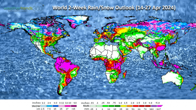
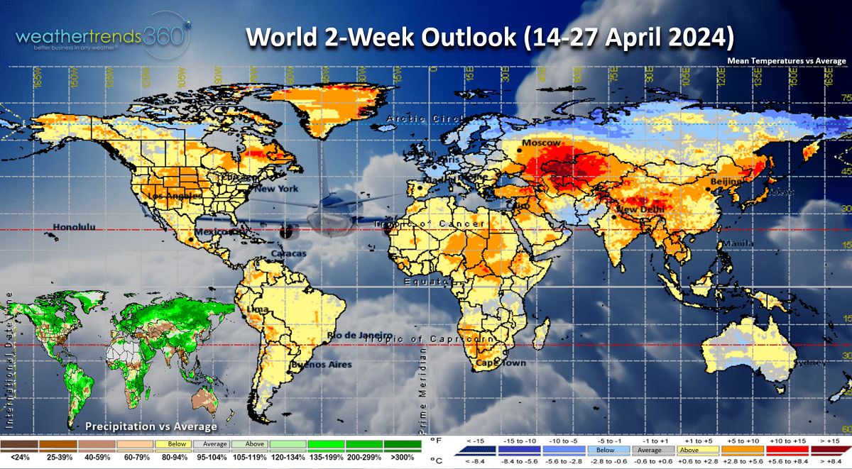
The World 2-week outlook (14-27 April) shows overall favorable conditions for seasonal sales in the U.S. but less favorable for Central Europe with cooler and wetter conditions.
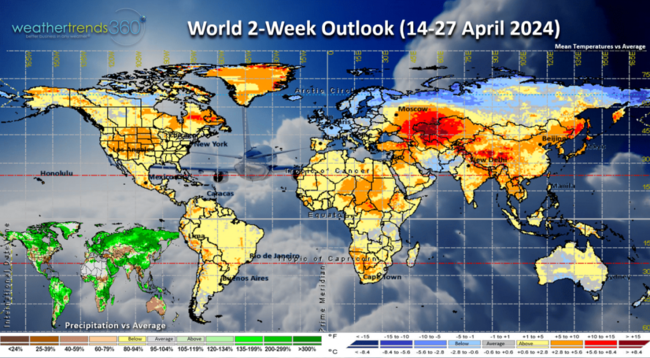
The World rain/snow outlook continues to show very wet conditions in many of the world Ag regions like the U.S. Corn Belt, Brazil (West Central) and Ukraine.
We end today's video with a time-lapse of the Solar Eclipse as seen from Niagara Falls, Canada. Mostly cloudy conditions made it exceptionally dark with a 13F temperature drop. Enjoy the show and have a great week.
Don't forget to follow us on social media for frequent updates: Twitter, YouTube, Pinterest and Linkedin.
Captain Kirk out.
In today's video update we start with a couple minutes of highlights of the Total Solar Eclipse as seen from Niagara Falls, Canada. There were a lot of clouds, but they broke up just in time to catch totality. CLICK ON IMAGES FOR A LARGER VIEW.

Zero doubt we're headed for a moderate to strong La Niña by Summer as the Equatorial Pacific continues to cool rapidly.
The subsurface water temperatures are well below average and that colder water is percolating to the surface. That will begin to alter the World weather patterns in the months ahead.
Drought is quickly being erased for most of the U.S. with only 38% of the country in dry to drought phases, least in 4 years and well below the average of 46% and last year at 52%. The peak drought phase was in November 2022 at 82% of the country in dry to drought phases due in part to the 3-year La Niña cycle.
Be careful with drought maps as they are lagging indicators. Iowa as an example still shows extreme drought but that's not accurate as the past 4.5 months have been the wettest in 5 years and 2nd wettest in 39 years with much above average rainfall. The U.S. overall has been the #1 wettest since Christmas, the gift (RAIN) that keeps on giving.
Last week (7-13 April) across the World shows the U.S. trending +0.4F warmer than last year and 5th warmest of the past 39 years. Rainfall was up +125% making it the #1 wettest 2nd week of April in over 39 years. Wet weather is a drag on store traffic, but the solar eclipse may have been a surge from TX to ME with millions flocking to the region. Most of the World was on the warm and very wet side due in large part to all the water vapor pumped into the atmosphere from El Nino and the Tonga Volcano a couple years ago. That oceanic volcanic water vapor will be in the atmosphere for several years which acts as a strong greenhouse gas.
Severe weather saw a bigger uptick last week with 62 tornadoes, 118 hail events and 322 wind events. Tornado counts are still the least in 3 years while Hail is the most in 7 years and wind down from last year but still above average. The severe weather threats will continue to ramp up April - June with a very active and destructive season.

This week (14-20 April) shows coast-to-coast Spring warmth with the U.S. trending +3.1F warmer than last year, warmest in 7 years and 5th warmest of the past 39 years. The Northeast is the one region trending cooler than last year. Rainfall is flat and 15th driest in 39 years with the heaviest rain in the Midwest and interior Northeast. Warm and Dry weather will bring near peak allergy and asthma suffering conditions for much of the country.
Next week (21-27 April) shows much cooler conditions for the East Coast which will dampen demand for Spring merchandise. The U.S. overall still trends +4.7F warmer than last year, warmest in 5 years and 10th warmest of the past 39 years. While rainfall is down -14% vs last year and 10th driest in 39 years, the severe weather threat is still very high in the Central U.S. from TX to IL. The Northeast appears to get a much needed break from the record wet conditions.

The World 2-week outlook (14-27 April) shows overall favorable conditions for seasonal sales in the U.S. but less favorable for Central Europe with cooler and wetter conditions.
The World rain/snow outlook continues to show very wet conditions in many of the world Ag regions like the U.S. Corn Belt, Brazil (West Central) and Ukraine.

We end today's video with a time-lapse of the Solar Eclipse as seen from Niagara Falls, Canada. Mostly cloudy conditions made it exceptionally dark with a 13F temperature drop. Enjoy the show and have a great week.

Don't forget to follow us on social media for frequent updates: Twitter, YouTube, Pinterest and Linkedin.
Captain Kirk out.