Captain's Log 20 Apr '24 Cool then much Warmer
Captain's Log
20 April '24: Happy Saturday! :)
https://www.youtube.com/watch?v=LjAQmi4D3RE
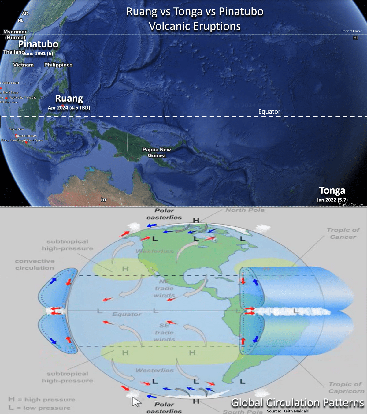
Another major volcanic eruption (Ruang - Indonesia) could have an impact on 2024 weather. Unlike the Tonga eruption in Jan 2022 which was in the Southern Hemisphere, Ruang is in the Northern Hemisphere circulation pattern and more likely to impact NH than SH. CLICK ON IMAGES FOR A LARGER VIEW.
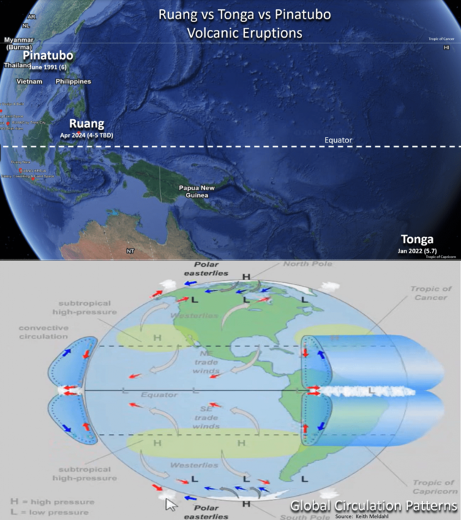
Ruang (Volcanic Explosivity Index = 4 tot 5) is currently pumping out Sulfur Dioxide (SO2) as opposed to the massive water vapor and SO2 with the oceanic Tonga eruption. This distinction is important as SO2 acts as a global cooling gas in the high atmosphere vs water vapor (H2O) is a greenhouse gas that tends to create global warming in high concentrations. After Tonga (VEI = 6)the Southern Hemisphere had the coolest 2022 in 6-10 years and then the World got very wet with all the atmospheric moisture added to the global weather circulation. Since the Tonga eruption was relatively far south in the sub-tropics, the influence of cooling did not make it into the Northern Hemisphere. While Ruang is not as far north as the Mt. Pinatubo (VEI = 6) eruption in 1991 that created a couple years go substantial global cooling, it is in the tropical Northern Hemisphere and could play a role in the year ahead if it continues to erupt. Keep you posted.

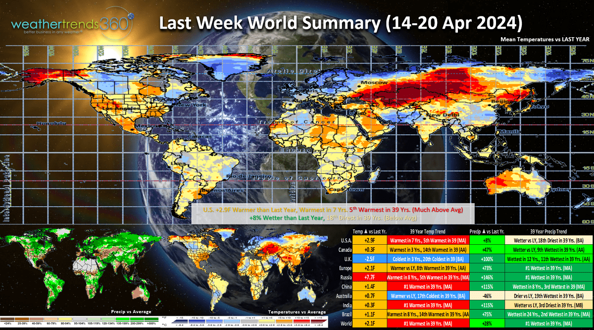
Last week (14-20 April) across the World shows the U.S. trending +2.9F warmer than last year, warmest in 7 years and 5th warmest of the past 39 years. Rainfall was up +8% vs last year but still 18th driest of the past 39 years. The U.K., Australia and Western Canada were the cold spots. The World overall was very wet trending #1 wettest in over 39 years in large part to the influence of the Tonga volcano 2-years ago and the weakening El Niño.
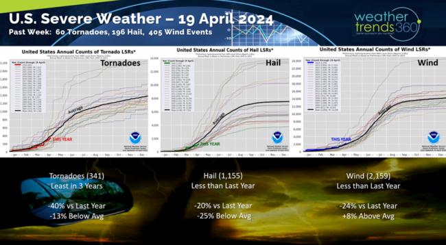
It was another active severe weather week with 60 tornadoes, 196 hail events and 405 high wind events reported. All three categories are still running below last year's levels. but the next couple months are very likely to be active.
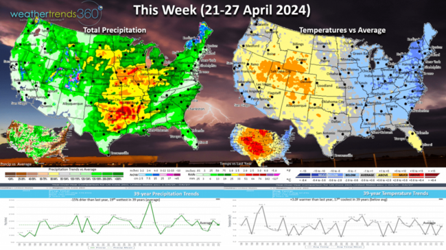
This week (21-27 April) shows a dramatic cooldown for the Eastern half of the country with warmer than average conditions in the Rockies. The U.S. overall still trends +3F warmer than last year but 17th coolest in 39 years with below average national temperatures. Rainfall down -15% vs last year but 19th wettest of the past 39 years with near average rainfall. Heaviest rain in the Central U.S. where more severe weather is highly likely. Overall, the week is generally unfavorable for Spring seasonal categories that do better in hotter/drier weather this time of year.

Next week (28 Apr - 4 May) shows a dramatic warming trend for much of the U.S. with the nation trending +6.5F warmer than last year and #1 warmest of the past 39 years. Rainfall up +19%, wettest in 3 years and 8th wettest of the past 39 years with more severe weather highly likely in the Central U.S. and Midwest. This is likely to be a much stronger week for seasonal merchandise sales including lawn and garden, allergy and asthma medications and Spring apparel.
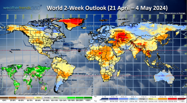
The World 2-week outlook (21 Apr - 4 May) shows North America generally warm and wet while Europe is quite cool and wet which is unfavorable for Spring categories.
We hope you have a great week ahead, and don't forget to follow us on social media for frequent updates: Twitter, YouTube, Pinterest and Linkedin.
Captain Kirk out.
https://www.youtube.com/watch?v=LjAQmi4D3RE
Another major volcanic eruption (Ruang - Indonesia) could have an impact on 2024 weather. Unlike the Tonga eruption in Jan 2022 which was in the Southern Hemisphere, Ruang is in the Northern Hemisphere circulation pattern and more likely to impact NH than SH. CLICK ON IMAGES FOR A LARGER VIEW.
Ruang (Volcanic Explosivity Index = 4 tot 5) is currently pumping out Sulfur Dioxide (SO2) as opposed to the massive water vapor and SO2 with the oceanic Tonga eruption. This distinction is important as SO2 acts as a global cooling gas in the high atmosphere vs water vapor (H2O) is a greenhouse gas that tends to create global warming in high concentrations. After Tonga (VEI = 6)the Southern Hemisphere had the coolest 2022 in 6-10 years and then the World got very wet with all the atmospheric moisture added to the global weather circulation. Since the Tonga eruption was relatively far south in the sub-tropics, the influence of cooling did not make it into the Northern Hemisphere. While Ruang is not as far north as the Mt. Pinatubo (VEI = 6) eruption in 1991 that created a couple years go substantial global cooling, it is in the tropical Northern Hemisphere and could play a role in the year ahead if it continues to erupt. Keep you posted.
Last week (14-20 April) across the World shows the U.S. trending +2.9F warmer than last year, warmest in 7 years and 5th warmest of the past 39 years. Rainfall was up +8% vs last year but still 18th driest of the past 39 years. The U.K., Australia and Western Canada were the cold spots. The World overall was very wet trending #1 wettest in over 39 years in large part to the influence of the Tonga volcano 2-years ago and the weakening El Niño.

It was another active severe weather week with 60 tornadoes, 196 hail events and 405 high wind events reported. All three categories are still running below last year's levels. but the next couple months are very likely to be active.

This week (21-27 April) shows a dramatic cooldown for the Eastern half of the country with warmer than average conditions in the Rockies. The U.S. overall still trends +3F warmer than last year but 17th coolest in 39 years with below average national temperatures. Rainfall down -15% vs last year but 19th wettest of the past 39 years with near average rainfall. Heaviest rain in the Central U.S. where more severe weather is highly likely. Overall, the week is generally unfavorable for Spring seasonal categories that do better in hotter/drier weather this time of year.
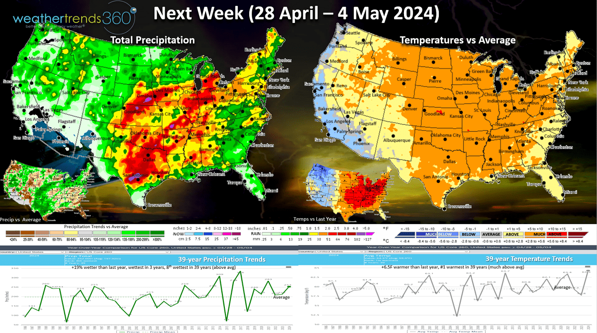
Next week (28 Apr - 4 May) shows a dramatic warming trend for much of the U.S. with the nation trending +6.5F warmer than last year and #1 warmest of the past 39 years. Rainfall up +19%, wettest in 3 years and 8th wettest of the past 39 years with more severe weather highly likely in the Central U.S. and Midwest. This is likely to be a much stronger week for seasonal merchandise sales including lawn and garden, allergy and asthma medications and Spring apparel.
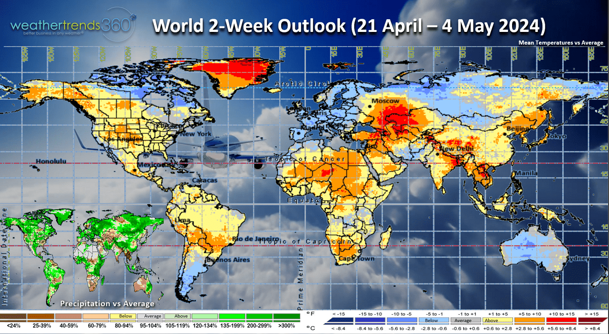
The World 2-week outlook (21 Apr - 4 May) shows North America generally warm and wet while Europe is quite cool and wet which is unfavorable for Spring categories.
We hope you have a great week ahead, and don't forget to follow us on social media for frequent updates: Twitter, YouTube, Pinterest and Linkedin.
Captain Kirk out.