Captain's Log 21 Oct '23 Cold & Snowy Start to November!
Captain's Log
21 Oct '23: Happy Saturday! :)
wt360 accurately projected a year ago that we'd go from Moderate La Niña to Strong El Niño here in 2023...now we're projecting a rapid change back to La Niña in Fall 2024. This rapid change will create havoc with World weather and very likely a very damaging year in the U.S. CLICK ON IMAGES FOR A LARGER VIEW.

2024 Billion dollar disasters are likely to be the most in 7 years with the most active tornado/hail season in 13 years, 22+ named storms in the Atlantic, El Nino induced Deep South ice storm, Nor'easter storms up the East Coast and an active late wildfire season. That's all we have to say about that for now. :)

The Winter set up is nothing like last year. Under the 3-year La Niña, Russia had three in a row dry Octobers with a slow start to the snowpack across Siberia. This year the wettest and snowiest conditions in 10 years. Yes that was a precursor to the very snowy U.S. Winter of 2013-2014. Just one of many cycles that play a role in the World's weather patterns.
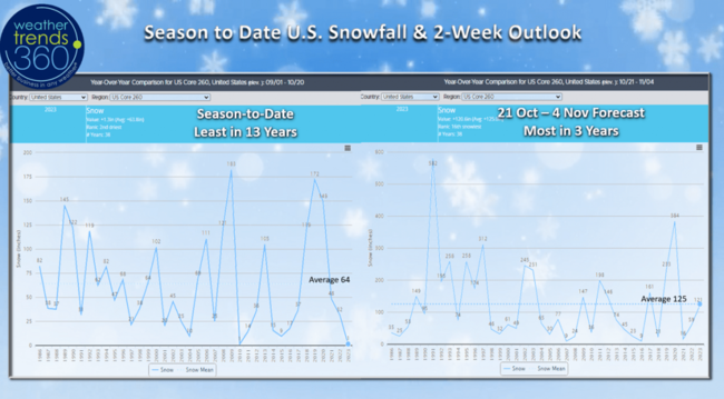
With El Niño the Fall is usually mild across North America and that has been the case. Snowfall starts off slowly, but we expect that to change as we get into the latter half of December into middle March with the snowiest U.S. Winter in 10 years. The wt360 U.S. 260 city snow index shows the slowest start to snow in 13 years, but the next two weeks show the most in 3 years.

The 6-day snowfall outlook shows the first major widespread snow event for the Northern Rockies and Plains this week! Snowfall up +741% over last year, most in 3 years and 3rd most in 38+ years.
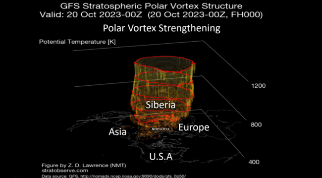
The Polar Vortex continues to strengthen, but some wobbling toward North America as we transition into November. This will allow some Polar air to invade Canada and the U.S. in early November. Last Winter the PV remained very strong for most of Winter keeping the cold bottled up at the North Pole, we expect a weaker PV this Winter.

The severe weather tornado/hail season is winding down for much of the U.S., but the Gulf Coast states still have risk this Fall and Winter season. Tornado counts still the most in 4 years, +9% above average, while incidents of hail are way up over last year, still -8% below average.
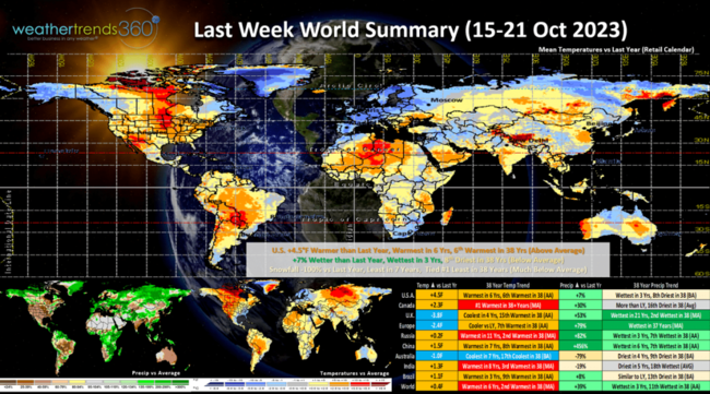
Last week (15-21 Oct) across the World shows the U.S. trending +4.5F warmer than last year, warmest in 6 years and 6th warmest in 38 years. Rainfall was up +7% vs last year, wettest in 3 years but still 8th driest of the past 38 years. Snowfall across 260 U.S. cities was tied for #1 least in 38 years. Overall, these are very negative trends for retail sales and Fall seasonal merchandise. Definitely starting to see signs that El Niño is impacting the weather pattern, but not entirely. This strong El Niño is likely to be a little different as it's also accompanied with an overall warm Pacific and warm Atlantic suggesting the Winter impact is not going to be typical. We saw that with the 2023 Atlantic and E. Pacific hurricane season which had the Atlantic far more active than typical with El Niño. Unfortunately, NOAA's forecast does not take into account all the cycles and assumes every El Niño is the same, they are not. It remains very dry in Australia as expected and this dryness will get worse with drought and wildfires for their Summer season.
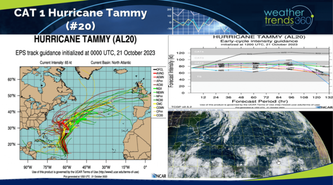
The Atlantic is still very much alive with 40 days left in the 2023 hurricane season. Hurricane Tammy (#20) is impacting the BVIs but appears to make a right turn into the open Atlantic. Some uncertainty here with some models suggesting it could head back toward U.S.
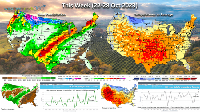
This week (22-28 Oct) is the last week of the retail Q3, and it ends on an unfavorable note. U.S. temperatures trend +2.6F warmer than last year, warmest in 23 years and 2nd warmest of the past 38 years. Rainfall down -8% vs last year, driest in 7 years but 19th wettest of the past 38. Signs of the cold front moving into the U.S. late in the week with what should be a nationwide cool down going into the front half of November. Unfortunately, this week is very unfavorable for retail seasonal category sales.
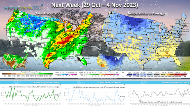
Next week (29 Oct - 4 Nov) shows a very strong week for seasonal merchandise sales! U.S. temperatures trend a very significant -7.5F colder than last year and 19th coldest of the past 38 years. This will likely be one of the top 2 strongest sales gains week for all of Q4 (Nov - Jan)! Rainfall is up +14% vs last year, wettest in 5 years and 10th wettest of the past 38 years. Snowfall also up +41% over last year, most in 4 years and 18th snowiest of the past 38. These are all very strong weather trends for seasonal merchandise sales.
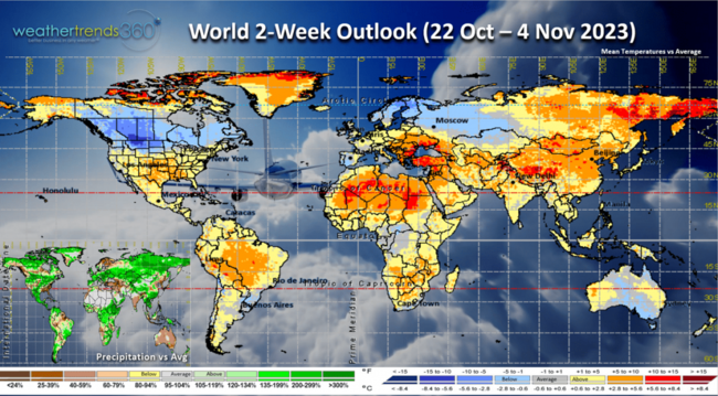
The World 2-week outlook (22 Oct - 4 Nov) shows the major cooling trend for Canada which will expand into the U.S. the front half of November. Europe unfavorably mild with it remains bone dry in Australia where their Spring is the driest in 29 years. This will impact their crops like Wheat.

In just a couple weeks it will be time to FALL BACK as Daylight Savings Time ends (Sunday 5 November 2am). Not happy about the very dark evenings ahead.

Another sign the cold weather is coming, Canadian Geese were heading south this morning. Soon we'll have the Snow Geese from Greenland landing here in Eastern PA as they migrate to the Chesapeake Bay.
Have a great weekend and week ahead. Don't forget to follow us on social media for frequent updates: Facebook, Twitter, YouTube, Pinterest and Linkedin.
- Captain Kirk out
wt360 accurately projected a year ago that we'd go from Moderate La Niña to Strong El Niño here in 2023...now we're projecting a rapid change back to La Niña in Fall 2024. This rapid change will create havoc with World weather and very likely a very damaging year in the U.S. CLICK ON IMAGES FOR A LARGER VIEW.
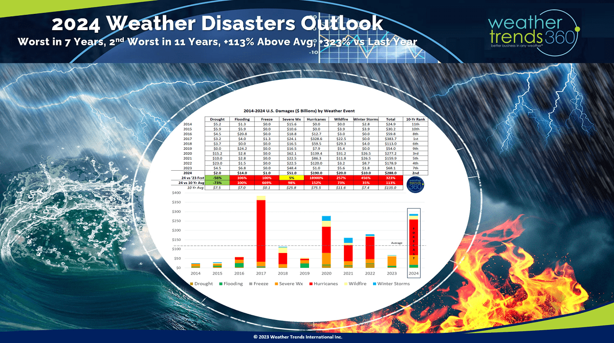
2024 Billion dollar disasters are likely to be the most in 7 years with the most active tornado/hail season in 13 years, 22+ named storms in the Atlantic, El Nino induced Deep South ice storm, Nor'easter storms up the East Coast and an active late wildfire season. That's all we have to say about that for now. :)
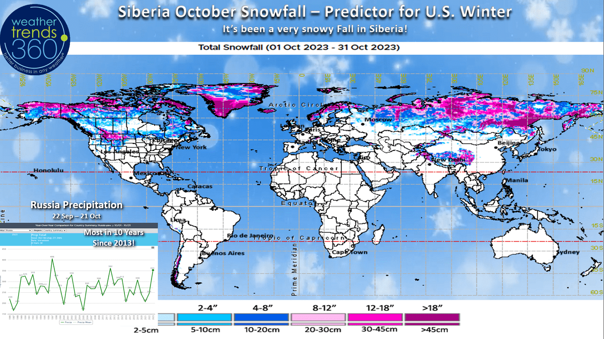
The Winter set up is nothing like last year. Under the 3-year La Niña, Russia had three in a row dry Octobers with a slow start to the snowpack across Siberia. This year the wettest and snowiest conditions in 10 years. Yes that was a precursor to the very snowy U.S. Winter of 2013-2014. Just one of many cycles that play a role in the World's weather patterns.
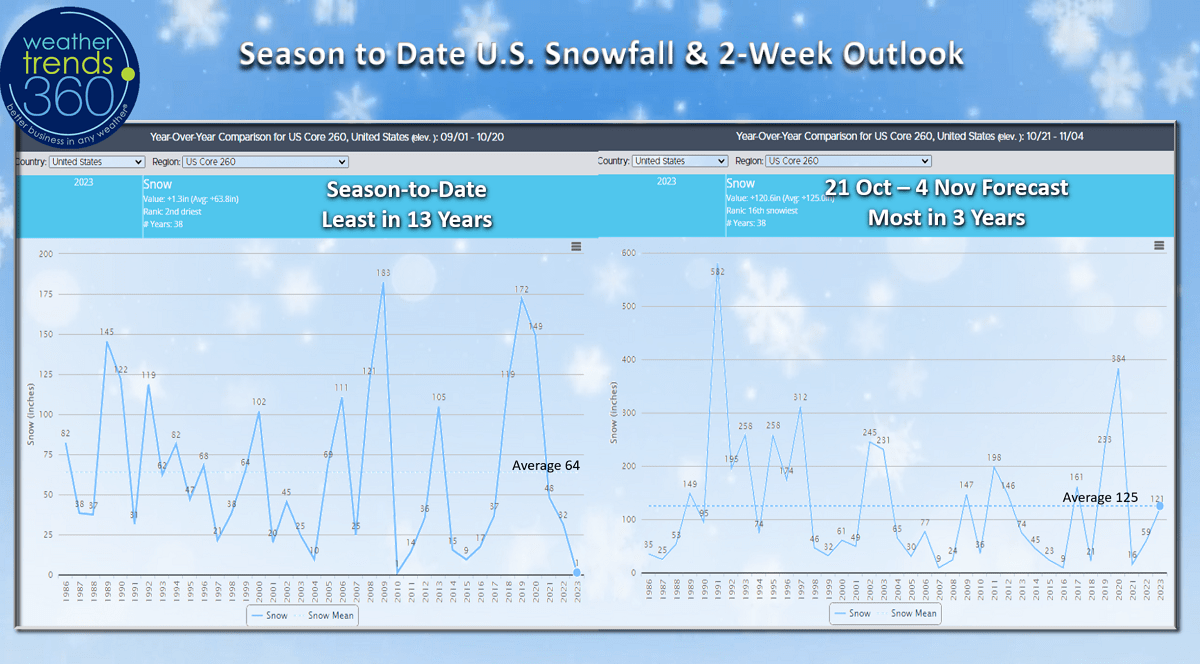
With El Niño the Fall is usually mild across North America and that has been the case. Snowfall starts off slowly, but we expect that to change as we get into the latter half of December into middle March with the snowiest U.S. Winter in 10 years. The wt360 U.S. 260 city snow index shows the slowest start to snow in 13 years, but the next two weeks show the most in 3 years.
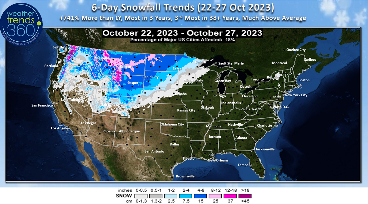
The 6-day snowfall outlook shows the first major widespread snow event for the Northern Rockies and Plains this week! Snowfall up +741% over last year, most in 3 years and 3rd most in 38+ years.

The Polar Vortex continues to strengthen, but some wobbling toward North America as we transition into November. This will allow some Polar air to invade Canada and the U.S. in early November. Last Winter the PV remained very strong for most of Winter keeping the cold bottled up at the North Pole, we expect a weaker PV this Winter.
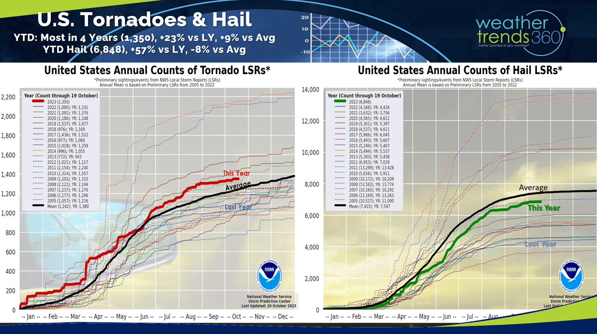
The severe weather tornado/hail season is winding down for much of the U.S., but the Gulf Coast states still have risk this Fall and Winter season. Tornado counts still the most in 4 years, +9% above average, while incidents of hail are way up over last year, still -8% below average.
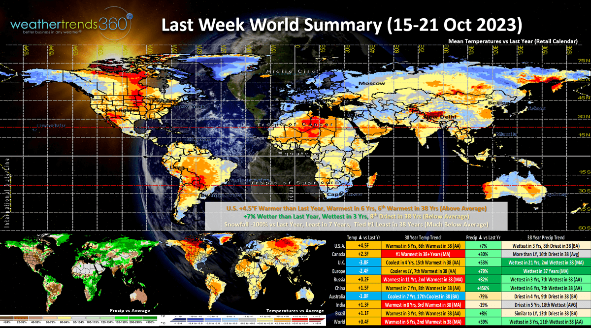
Last week (15-21 Oct) across the World shows the U.S. trending +4.5F warmer than last year, warmest in 6 years and 6th warmest in 38 years. Rainfall was up +7% vs last year, wettest in 3 years but still 8th driest of the past 38 years. Snowfall across 260 U.S. cities was tied for #1 least in 38 years. Overall, these are very negative trends for retail sales and Fall seasonal merchandise. Definitely starting to see signs that El Niño is impacting the weather pattern, but not entirely. This strong El Niño is likely to be a little different as it's also accompanied with an overall warm Pacific and warm Atlantic suggesting the Winter impact is not going to be typical. We saw that with the 2023 Atlantic and E. Pacific hurricane season which had the Atlantic far more active than typical with El Niño. Unfortunately, NOAA's forecast does not take into account all the cycles and assumes every El Niño is the same, they are not. It remains very dry in Australia as expected and this dryness will get worse with drought and wildfires for their Summer season.

The Atlantic is still very much alive with 40 days left in the 2023 hurricane season. Hurricane Tammy (#20) is impacting the BVIs but appears to make a right turn into the open Atlantic. Some uncertainty here with some models suggesting it could head back toward U.S.

This week (22-28 Oct) is the last week of the retail Q3, and it ends on an unfavorable note. U.S. temperatures trend +2.6F warmer than last year, warmest in 23 years and 2nd warmest of the past 38 years. Rainfall down -8% vs last year, driest in 7 years but 19th wettest of the past 38. Signs of the cold front moving into the U.S. late in the week with what should be a nationwide cool down going into the front half of November. Unfortunately, this week is very unfavorable for retail seasonal category sales.
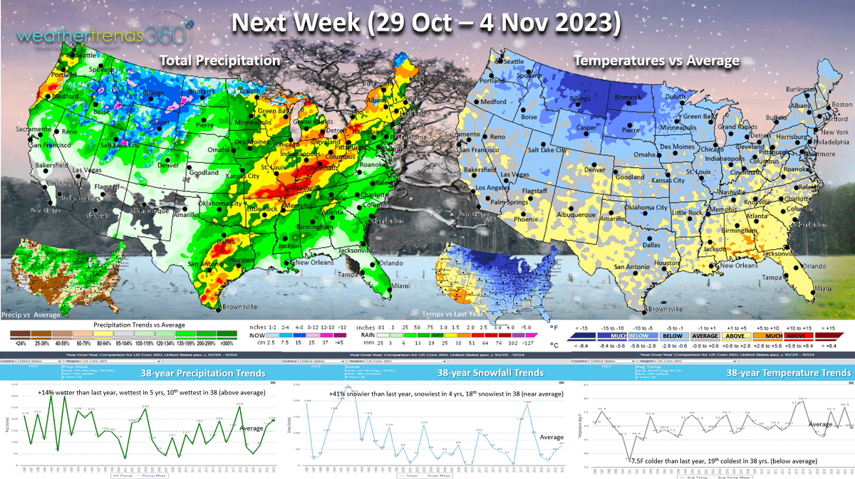
Next week (29 Oct - 4 Nov) shows a very strong week for seasonal merchandise sales! U.S. temperatures trend a very significant -7.5F colder than last year and 19th coldest of the past 38 years. This will likely be one of the top 2 strongest sales gains week for all of Q4 (Nov - Jan)! Rainfall is up +14% vs last year, wettest in 5 years and 10th wettest of the past 38 years. Snowfall also up +41% over last year, most in 4 years and 18th snowiest of the past 38. These are all very strong weather trends for seasonal merchandise sales.

The World 2-week outlook (22 Oct - 4 Nov) shows the major cooling trend for Canada which will expand into the U.S. the front half of November. Europe unfavorably mild with it remains bone dry in Australia where their Spring is the driest in 29 years. This will impact their crops like Wheat.

In just a couple weeks it will be time to FALL BACK as Daylight Savings Time ends (Sunday 5 November 2am). Not happy about the very dark evenings ahead.

Another sign the cold weather is coming, Canadian Geese were heading south this morning. Soon we'll have the Snow Geese from Greenland landing here in Eastern PA as they migrate to the Chesapeake Bay.
Have a great weekend and week ahead. Don't forget to follow us on social media for frequent updates: Facebook, Twitter, YouTube, Pinterest and Linkedin.
- Captain Kirk out