Captain's Log 27 Apr '24 Roller Coaster Temps & More Severe Weather
Captain's Log
27 Apr '24: Hard to say happy Saturday with all the severe weather.
Last week (21-27 April) World summary shows the U.S. trending 3F warmer than last year but still 17th coldest of the past 39 years with below average national temperatures. Frost and Freezes were common throughout the Midwest and Northeast impacting some crops. Rainfall was down -29% vs last year and 12th driest of the past 39 years. The cold spot was clearly the East Coast where demand for seasonal items would have been soft. CLICK ON IMAGES FOR A LARGER VIEW.

Around the World it was downright cold in the U.K. Europe trending the coldest in 7 years with below average temperatures. The hots spots were in China and India #1 warmest in 39+ years.

A very active severe weather pattern with several large destructive tornadoes. One was in Western Omaha Nebraska near wt360 CTO's house! The 3-day outlook from the Strom Prediction Center shows another active day today and Sunday. Be safe and heed all warnings!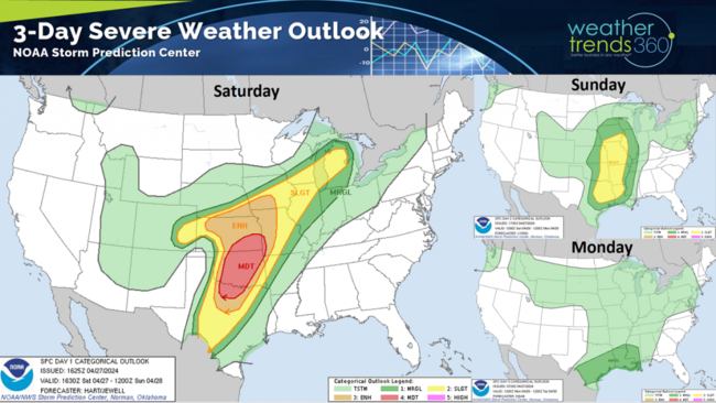
Nationally we added 89 tornadoes, 90 wind events and 143 hail events the past week. This severe weather trend very likely to remain very active the next couple weeks in the Central U.S.
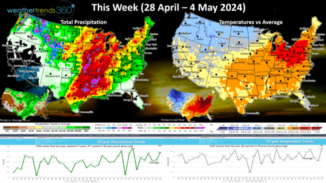
This week (28 Apr - 4 May) shows a very concerning weather pattern with a strong cold front clashing with warm air out in front of it - a classic widespread severe weather scenario in the Central U.S. The week overall trends 6F warmer than last year and #1 warmest of the past 39 years. A big warm up in the East will certainly spur some Spring seasonal merchandise sales. Rainfall up +35% vs last year, wettest in 7 years and 3rd wettest of the past 39 years with much above average rainfall. The strong cold front will bring widespread frost and freezes to the upper Plains and spilling into the Midwest crop regions 3-5 May.

The wt360 Ag FarmCast outlook issued months ago warned of a late frost and freeze in early May and that certainly looks to happen.
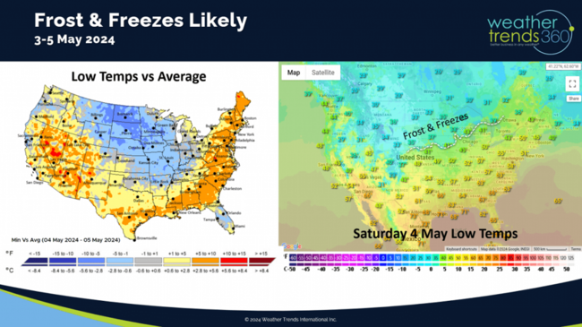
Anywhere from Nebraska to Iowa into northern Illinois likely to see frost and freezes next weekend. These temps could go much colder.
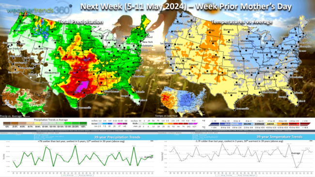
Next Week (5-11 May) is the week prior to Mother's Day (12th) with a strong cold front sweeping the Central and Eastern U.S. The week overall looks to trend -1.7F cooler than last year, coolest in 3 years but 16th warmest of the past 39 years for the U.S. overall. Seasonal holiday sales likely to be strongest in the West and much lower in the Central U.S. and East. Rainfall up +7% vs last year, wettest in 5 years and 12th wettest of the past 39 years. Severe weather may shift a bit further south into Texas to Kansas and Missouri.
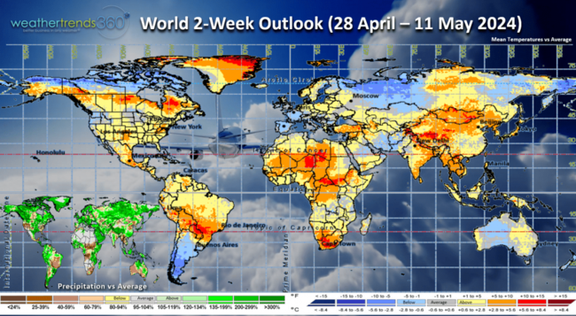
The World 2-week outlook (28 Apr - 11 May) shows a moderating trend across Europe and a continued transition pattern from cool to warm back to cool in the U.S.
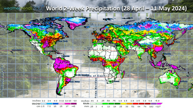
World precipitation shows very heavy rain in the U.S. and Europe but a very dry period across Brazil.
We hope you have a great week ahead and don't forget to follow us on social media for frequent updates: Twitter, YouTube, Pinterest and Linkedin.
Captain Kirk out.
Last week (21-27 April) World summary shows the U.S. trending 3F warmer than last year but still 17th coldest of the past 39 years with below average national temperatures. Frost and Freezes were common throughout the Midwest and Northeast impacting some crops. Rainfall was down -29% vs last year and 12th driest of the past 39 years. The cold spot was clearly the East Coast where demand for seasonal items would have been soft. CLICK ON IMAGES FOR A LARGER VIEW.
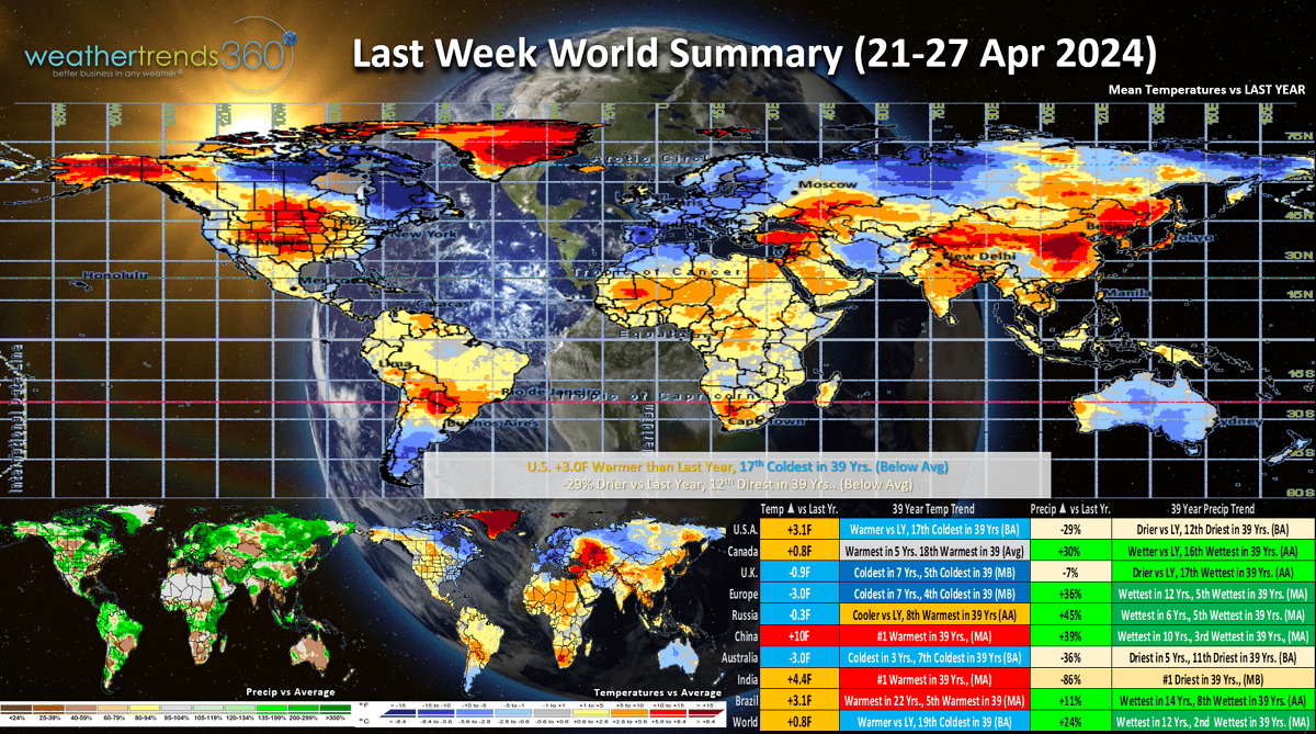
Around the World it was downright cold in the U.K. Europe trending the coldest in 7 years with below average temperatures. The hots spots were in China and India #1 warmest in 39+ years.
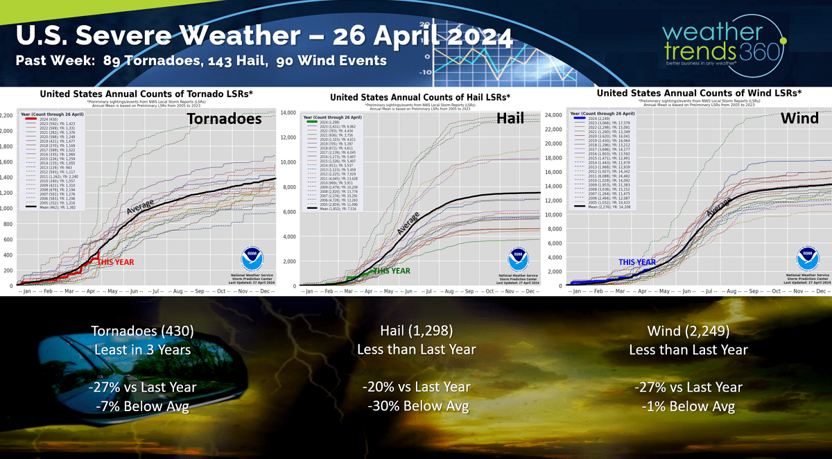
A very active severe weather pattern with several large destructive tornadoes. One was in Western Omaha Nebraska near wt360 CTO's house! The 3-day outlook from the Strom Prediction Center shows another active day today and Sunday. Be safe and heed all warnings!

Nationally we added 89 tornadoes, 90 wind events and 143 hail events the past week. This severe weather trend very likely to remain very active the next couple weeks in the Central U.S.

This week (28 Apr - 4 May) shows a very concerning weather pattern with a strong cold front clashing with warm air out in front of it - a classic widespread severe weather scenario in the Central U.S. The week overall trends 6F warmer than last year and #1 warmest of the past 39 years. A big warm up in the East will certainly spur some Spring seasonal merchandise sales. Rainfall up +35% vs last year, wettest in 7 years and 3rd wettest of the past 39 years with much above average rainfall. The strong cold front will bring widespread frost and freezes to the upper Plains and spilling into the Midwest crop regions 3-5 May.
The wt360 Ag FarmCast outlook issued months ago warned of a late frost and freeze in early May and that certainly looks to happen.

Anywhere from Nebraska to Iowa into northern Illinois likely to see frost and freezes next weekend. These temps could go much colder.
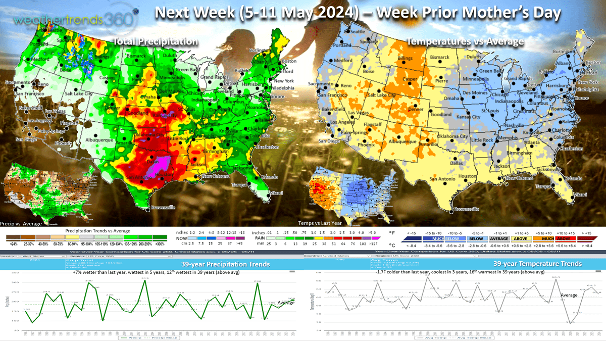
Next Week (5-11 May) is the week prior to Mother's Day (12th) with a strong cold front sweeping the Central and Eastern U.S. The week overall looks to trend -1.7F cooler than last year, coolest in 3 years but 16th warmest of the past 39 years for the U.S. overall. Seasonal holiday sales likely to be strongest in the West and much lower in the Central U.S. and East. Rainfall up +7% vs last year, wettest in 5 years and 12th wettest of the past 39 years. Severe weather may shift a bit further south into Texas to Kansas and Missouri.

The World 2-week outlook (28 Apr - 11 May) shows a moderating trend across Europe and a continued transition pattern from cool to warm back to cool in the U.S.

World precipitation shows very heavy rain in the U.S. and Europe but a very dry period across Brazil.
We hope you have a great week ahead and don't forget to follow us on social media for frequent updates: Twitter, YouTube, Pinterest and Linkedin.
Captain Kirk out.