Captain's Log 3 Jun '23 Coolest start to June in 4 Years, #1 Driest
Captain's Log
3 June '23: Happy Saturday! :)
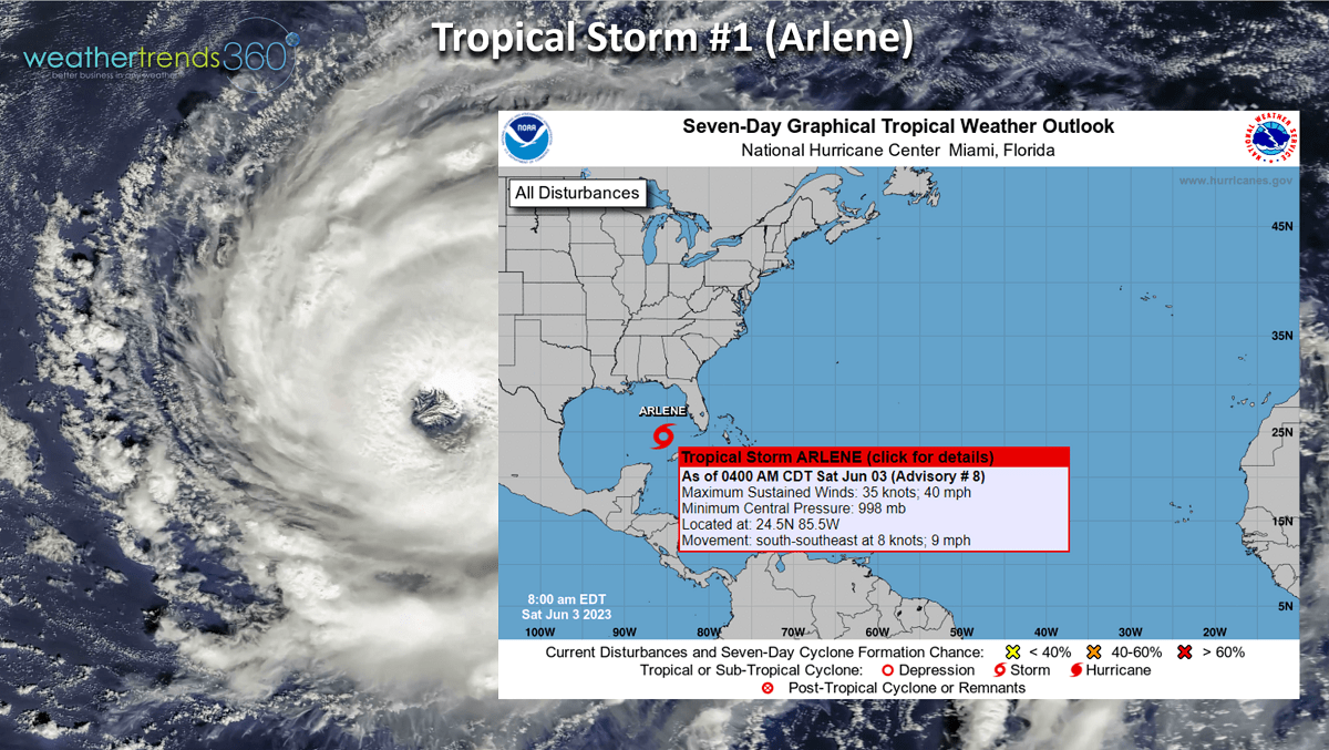
The Atlantic hurricane season just started 1 June and we already have our first named Tropical Storm of the season - Arlene. This is actually the 2nd tropical system of the 2023 season with a sub-tropical storm that wasn't named back in January along the East Coast. Arlene will most likely remain a fish storm well West of Florida Keys before weakening. CLICK ON IMAGES FOR A LARGER VIEW.
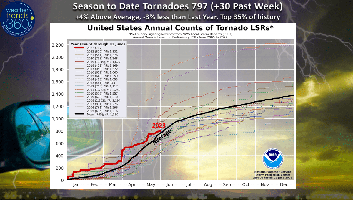
Despite the very dry week nationally, we still managed to add 30 more tornadoes this week. Season to date is still +4% above average and in the top 35% of history, but we're now trending -3% less than last year.
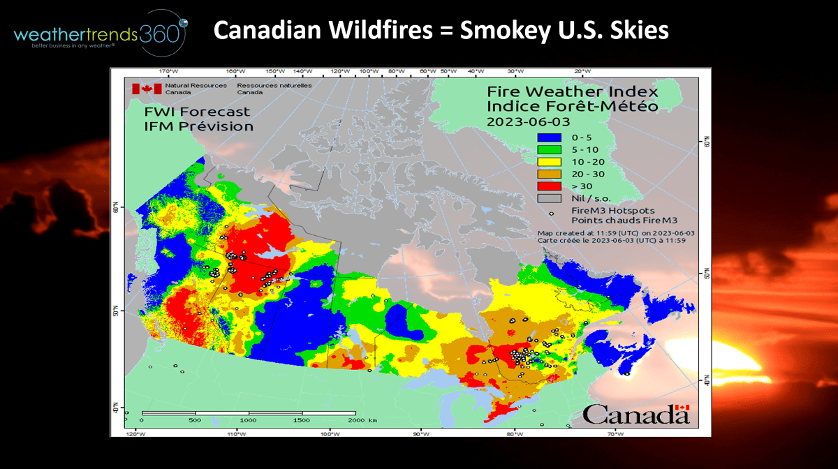
With the dry U.S. and Canada pattern, the larger wildfires in Canada continue pump smoke high into the Jet Stream with occasional intrusions into the U.S. It been a smokie hazy sky in parts of the U.S. due to these fires that have burned over 3 million acres in mainly Western Canada.
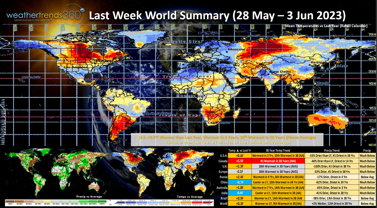
A recap of last week (28 May - 3 Jun) across the World shows the U.S. trending +0.6F warmer than last year, warmest in 3 years and 10th warmest in 38 years. Rainfall was down -55% vs last year nationally making it the # 1 driest in over 38 years. These are generally favorable trends for stronger retail sales with the caveat that the South and Southeast were relatively cooler suppressing demand for hot summer seasonal categories a bit. Canada was the #1 hottest in over 38 years and driest in 14 years which are favorable for stronger late Spring seasonal sales. Most of the populate areas of the world trend much drier with drought concerns developing in China and India.
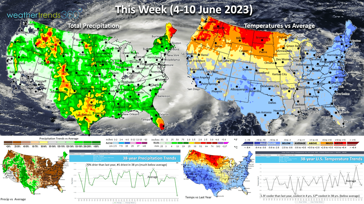
This week (4-10 Jun) back to the cooler trends with the U.S. trending -1.3F cooler than last year, coolest in 4 years and 12th coolest in 38 years with below average national temperatures. The cool spots are the East Coast and The Southwest while the heat returns to the Pacific Northwest and Upper Plains. Rainfall again very sparse, trending down -70% vs last year and #1 driest in over 38 years. Ironically the drought parched areas of the South Central Plains are the wettest spot as is South Florida with some influence from T.S. Arlene.
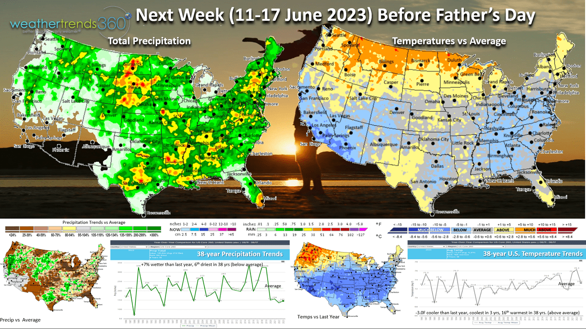
Next week (11-17 Jun) before Father's Day shows some moderation but still -3.0F cooler than last year, coolest in 3 years but 16th warmest of the past 38 years. This is still a negative for hot Summer categories like AC, cold beverages but a positive for allergy (grass) medications, pool supplies and sun care. Father's Day sales likely to be a bit soft in the East.
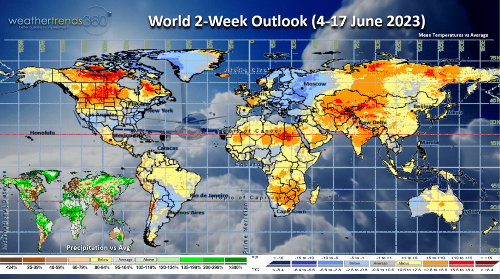
The 2-week World outlook (4-17 Jun) shows the same general theme of the hottest weather in the Pacific Northwest U.S., Canada and Central Europe. The front half of June in the U.S. trends the coolest in 4 years and #1 driest in 38+ years. These are negative trends for hot categories like AC, auto batteries, cold beverages but the dry is good for outdoor categories like pool supplies, sun care and outdoor dining. Hot and dry in India will continue to be a negative for many crops (sugar) and dairy production. With El Niño developing, a wetter pattern should begin to develop for the U.S. Summer with more cooler trends.
We hope you have a great weekend and week ahead. Don't forget to follow us on social media for frequent updates: Facebook, Twitter, YouTube, Pinterest and Linkedin.
- Captain Kirk out.