Star Date 10 May 2018 Thursday Update
Captain's Log
10 May 2018 Update. Happy Thursday!
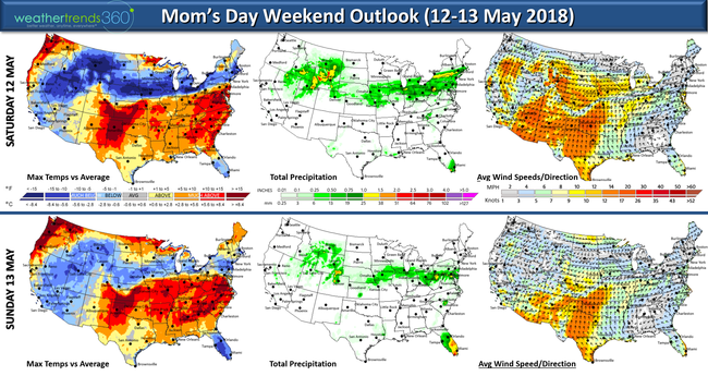
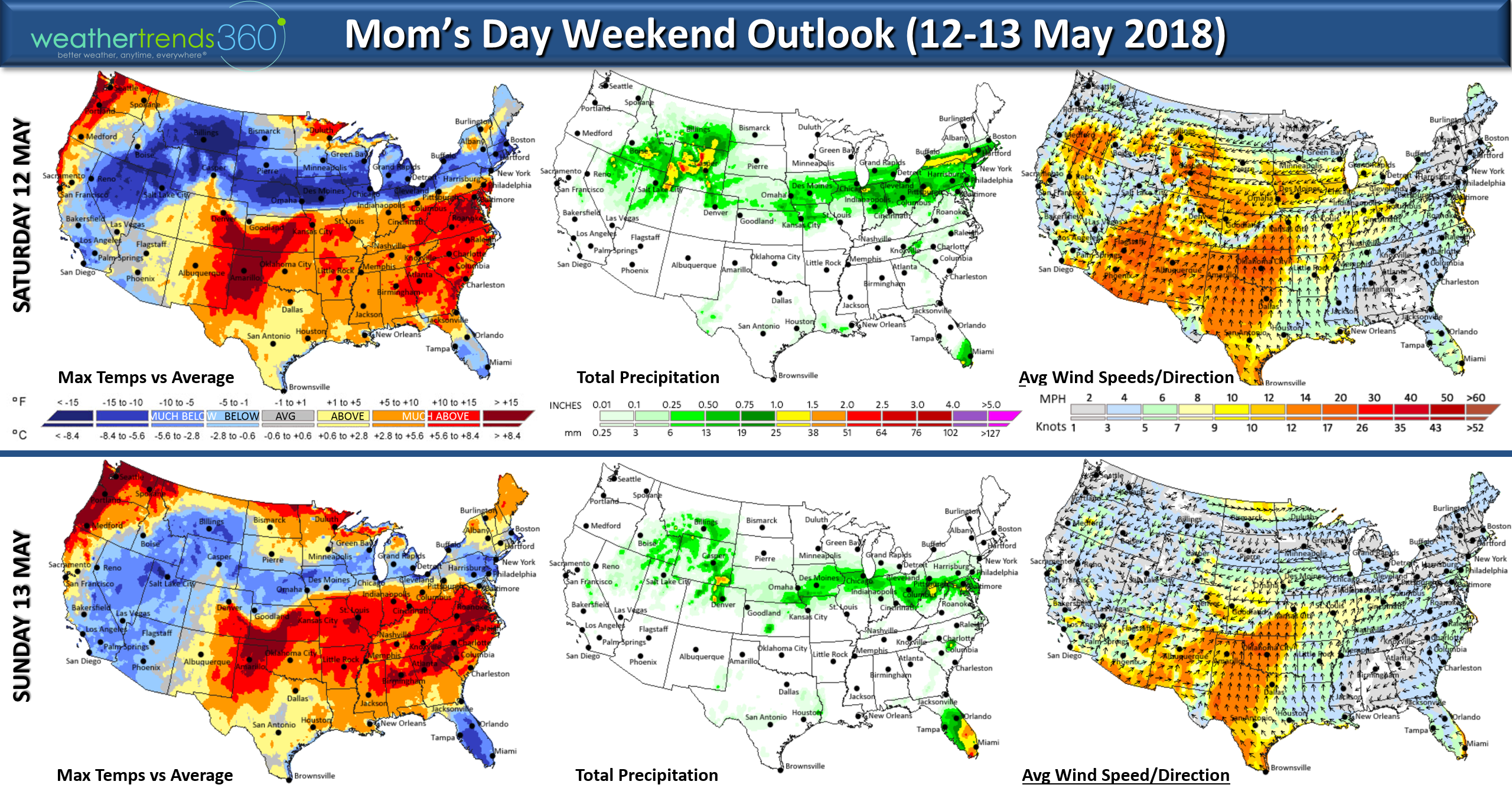
The Mother's Day weekend looks a bit cool and stormy from the Midwest to Northeast/Middle Atlantic with a very sharp dividing line between cold/wet and hot/dry to the South. CLICK ON IMAGES FOR LARGER VIEW.
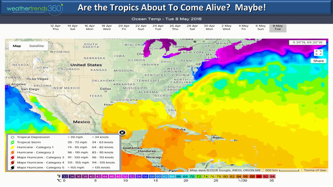
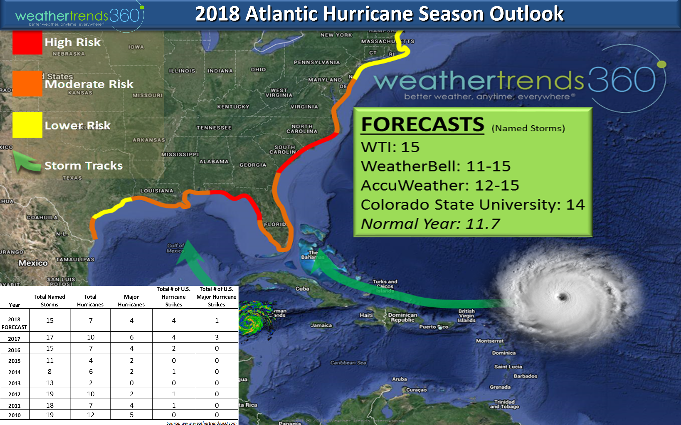
While the 2018 Atlantic Hurricane Season is still a few weeks away from the official start 1 June, models have been hinting at something developing in the SW Caribbean where water temperatures are 82F to 86F. Very favorable for development even if a bit early. For now something to watch late next week.
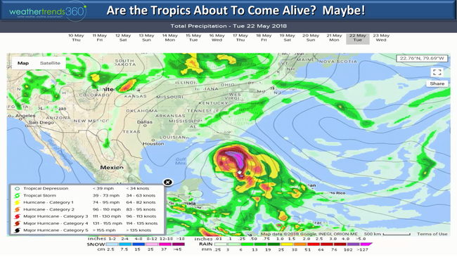
Some models take what would be Alberto into the Gulf of Mexico. We are worried about Florida and the East Coast this season for a couple hurricane landfalls, possibly a major hurricane landfall so never too early to start preparing.
Have a great Mother's Day!
8 May 2018 Happy Tuesday! :)
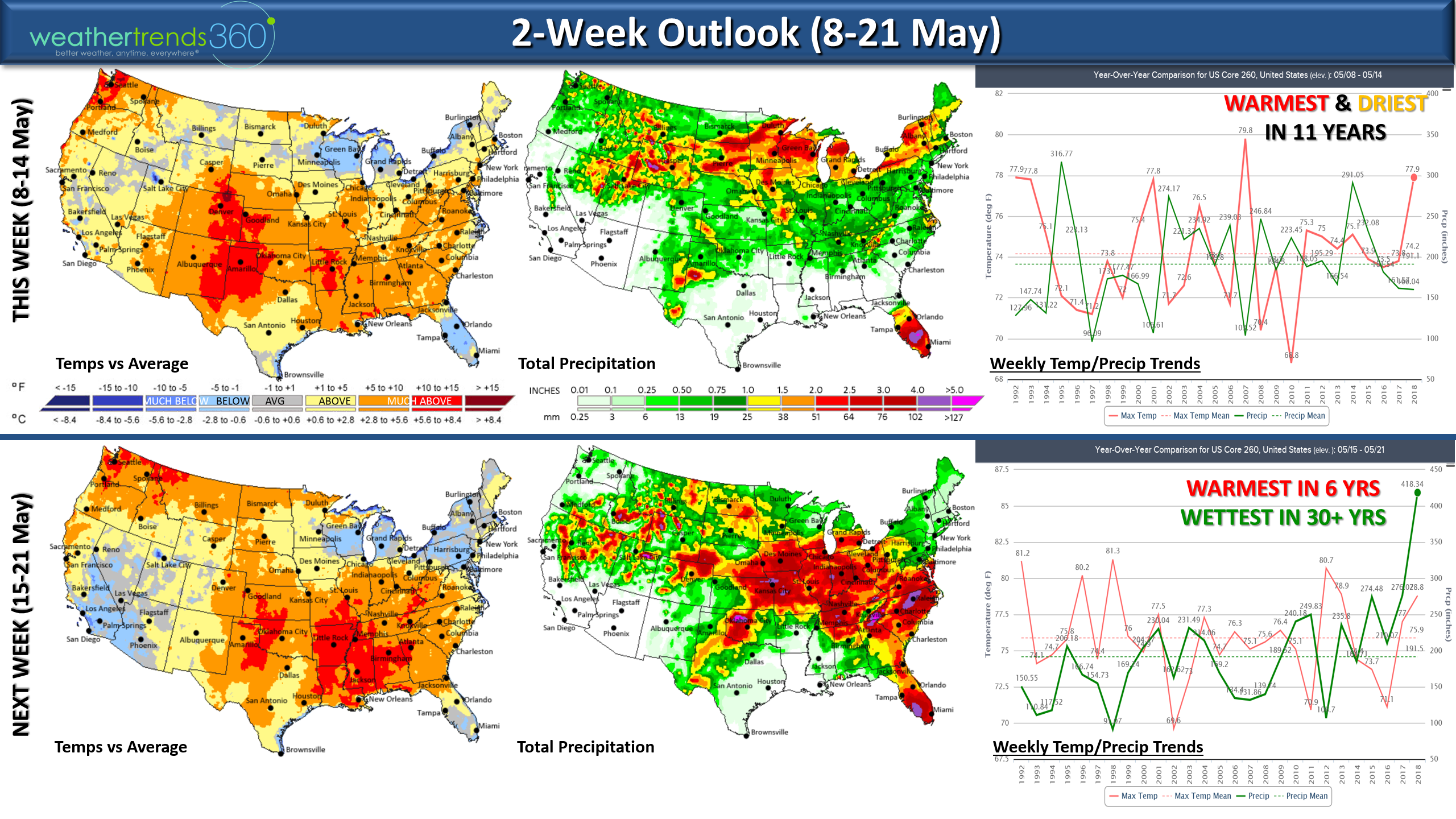
It's pretty amazing after the coldest/snowiest April in 21 years flipped to what should be the warmest May in 6 years for the U.S. overall. For this first week, the month is trending near record hot for the U.S. overall. CLICK ON IMAGES FOR LARGER VIEW
THIS WEEK (8-14 MAY) will trend the warmest and driest in 11 years for the U.S. as a whole continuing the very warm start to the month. The severe weather threat this week is greatly diminished from last week but still some risk in the Ohio Valley mid-week.

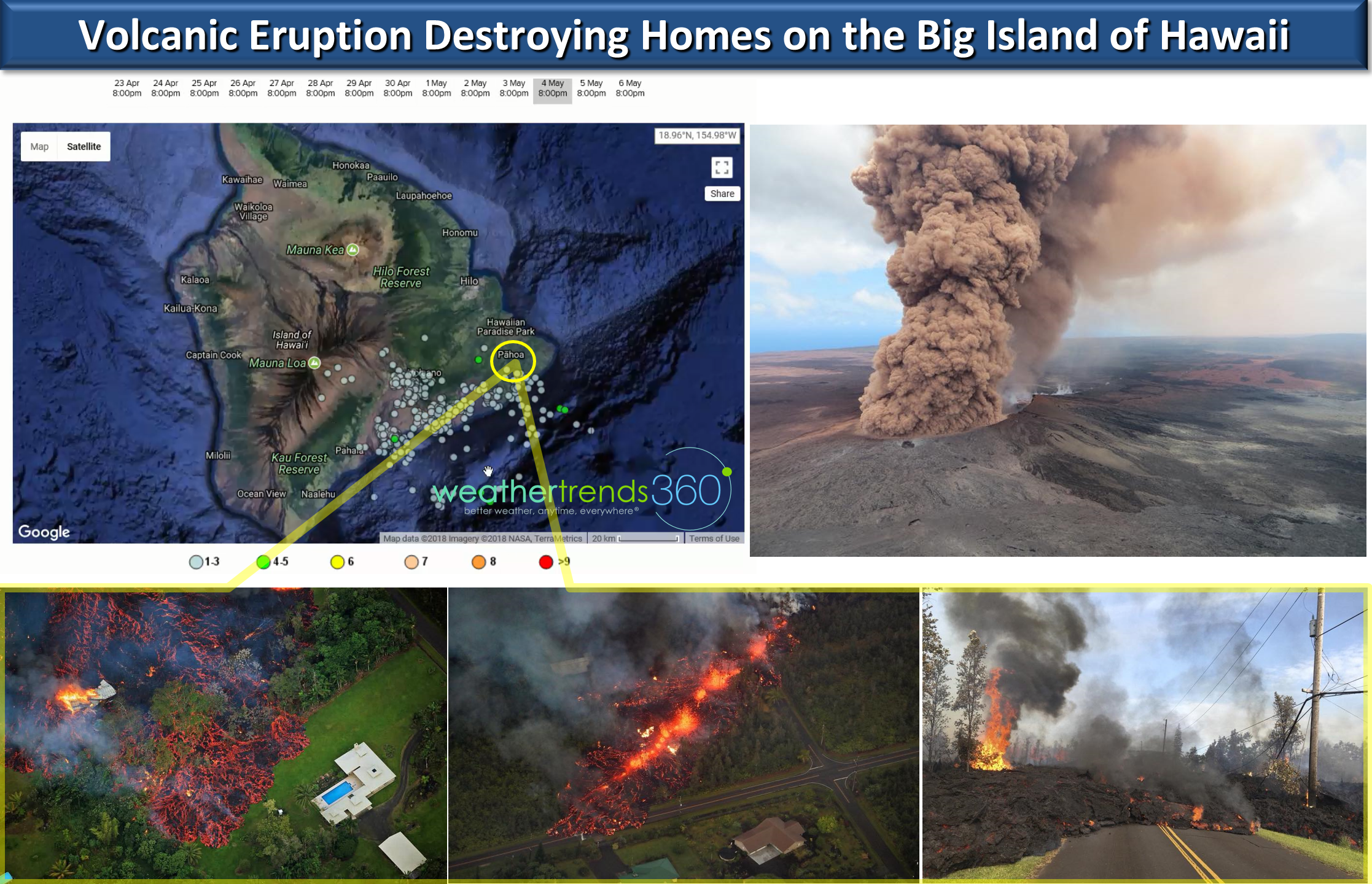
Out in Paradiseit's anything but with the Kilauea volcano spewing lava in neighborhoods south of Hilo Hawaii on the Big Island. As a kid we left Hawaii in the Summer of 1983 to move back East and that's when Kilauea became active again. It's been on and off active for the past 35 years and one of the most active volcanoes on Earth.

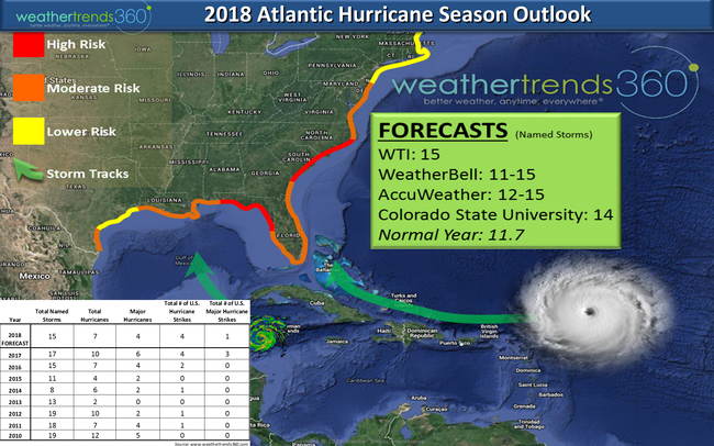
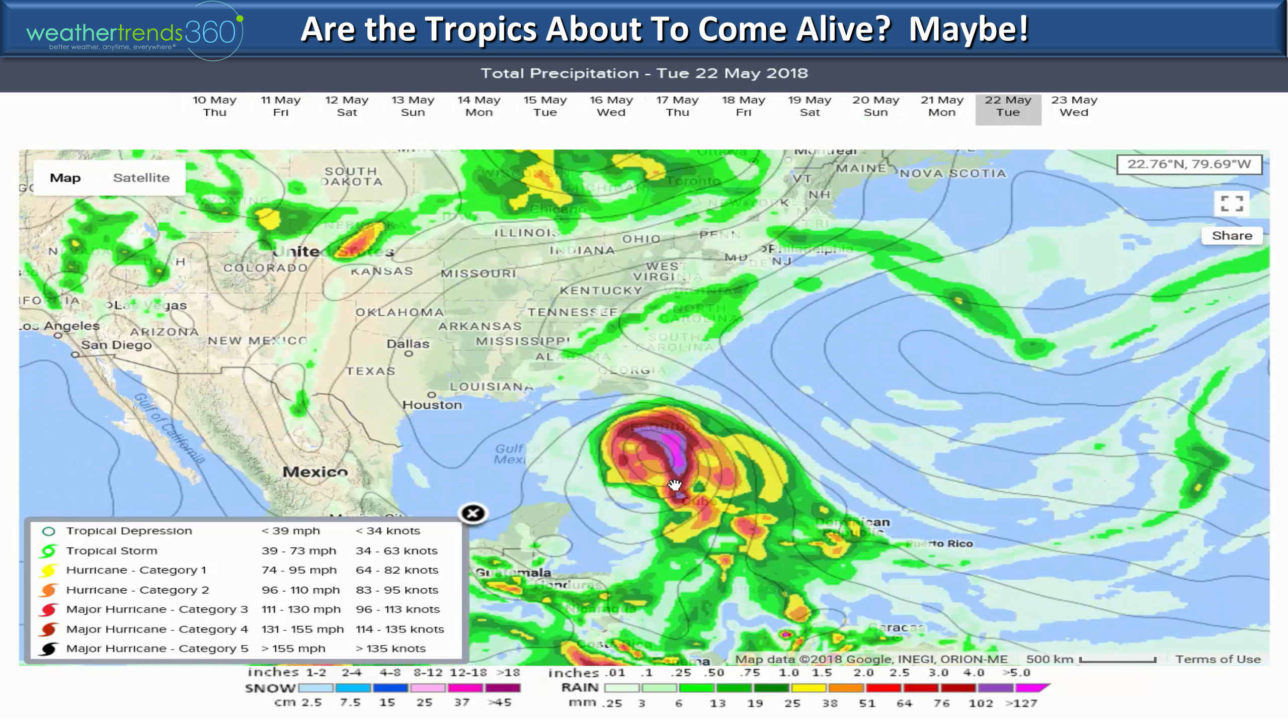
NEXT WEEK (15-21 MAY) will likely trend the warmest in 6 years and possibly the wettest in 30+ years for the U.S. overall. Very stormy conditions possible from the Midwest to the Middle Atlantic with Florida getting some much needed rain. Models are hinting that the hurricane season could flare up a bit early later next week with a system in the Deep Southwest Caribbean...a bit out there in model imagination land but water temps are trending 1-2ºF above average in the lower 80s so conditions are somewhat favorable for the first system of the season. A season that should end up above average according to most forecasting services, including weathertrends360. Please contact our sales team (sales@weathertrends360.comor call 610-807-0118 for more information) for our new very detailed hurricane and severe weather reports that project month and development areas for the 2018 season - it's a very useful new long range report with in-season updates.
We hope you have a great week! Also, we have a new YOUTUBE page where we will start posting several weekly updates so please subscribe. We have to get a 100 subscribers to have our new page listed with YOUTUBE so thank you in advance.
You can also follow us on Facebook and Twitter for frequent updates.
- Captain Kirk out.
The Mother's Day weekend looks a bit cool and stormy from the Midwest to Northeast/Middle Atlantic with a very sharp dividing line between cold/wet and hot/dry to the South. CLICK ON IMAGES FOR LARGER VIEW.
While the 2018 Atlantic Hurricane Season is still a few weeks away from the official start 1 June, models have been hinting at something developing in the SW Caribbean where water temperatures are 82F to 86F. Very favorable for development even if a bit early. For now something to watch late next week.
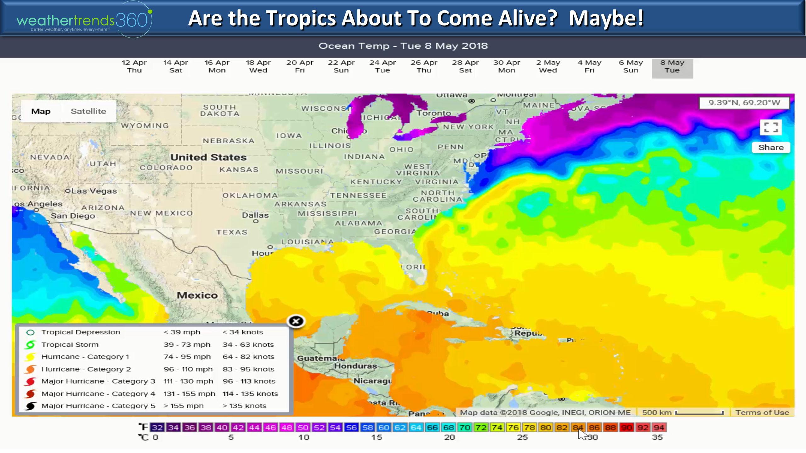
Some models take what would be Alberto into the Gulf of Mexico. We are worried about Florida and the East Coast this season for a couple hurricane landfalls, possibly a major hurricane landfall so never too early to start preparing.
Have a great Mother's Day!
8 May 2018 Happy Tuesday! :)
It's pretty amazing after the coldest/snowiest April in 21 years flipped to what should be the warmest May in 6 years for the U.S. overall. For this first week, the month is trending near record hot for the U.S. overall. CLICK ON IMAGES FOR LARGER VIEW
THIS WEEK (8-14 MAY) will trend the warmest and driest in 11 years for the U.S. as a whole continuing the very warm start to the month. The severe weather threat this week is greatly diminished from last week but still some risk in the Ohio Valley mid-week.
Out in Paradiseit's anything but with the Kilauea volcano spewing lava in neighborhoods south of Hilo Hawaii on the Big Island. As a kid we left Hawaii in the Summer of 1983 to move back East and that's when Kilauea became active again. It's been on and off active for the past 35 years and one of the most active volcanoes on Earth.
NEXT WEEK (15-21 MAY) will likely trend the warmest in 6 years and possibly the wettest in 30+ years for the U.S. overall. Very stormy conditions possible from the Midwest to the Middle Atlantic with Florida getting some much needed rain. Models are hinting that the hurricane season could flare up a bit early later next week with a system in the Deep Southwest Caribbean...a bit out there in model imagination land but water temps are trending 1-2ºF above average in the lower 80s so conditions are somewhat favorable for the first system of the season. A season that should end up above average according to most forecasting services, including weathertrends360. Please contact our sales team (sales@weathertrends360.comor call 610-807-0118 for more information) for our new very detailed hurricane and severe weather reports that project month and development areas for the 2018 season - it's a very useful new long range report with in-season updates.
We hope you have a great week! Also, we have a new YOUTUBE page where we will start posting several weekly updates so please subscribe. We have to get a 100 subscribers to have our new page listed with YOUTUBE so thank you in advance.
You can also follow us on Facebook and Twitter for frequent updates.
- Captain Kirk out.