Star Date 13 March 2017 Monday
Captain's Log
Good morning...the calm before the epic March snow storm!
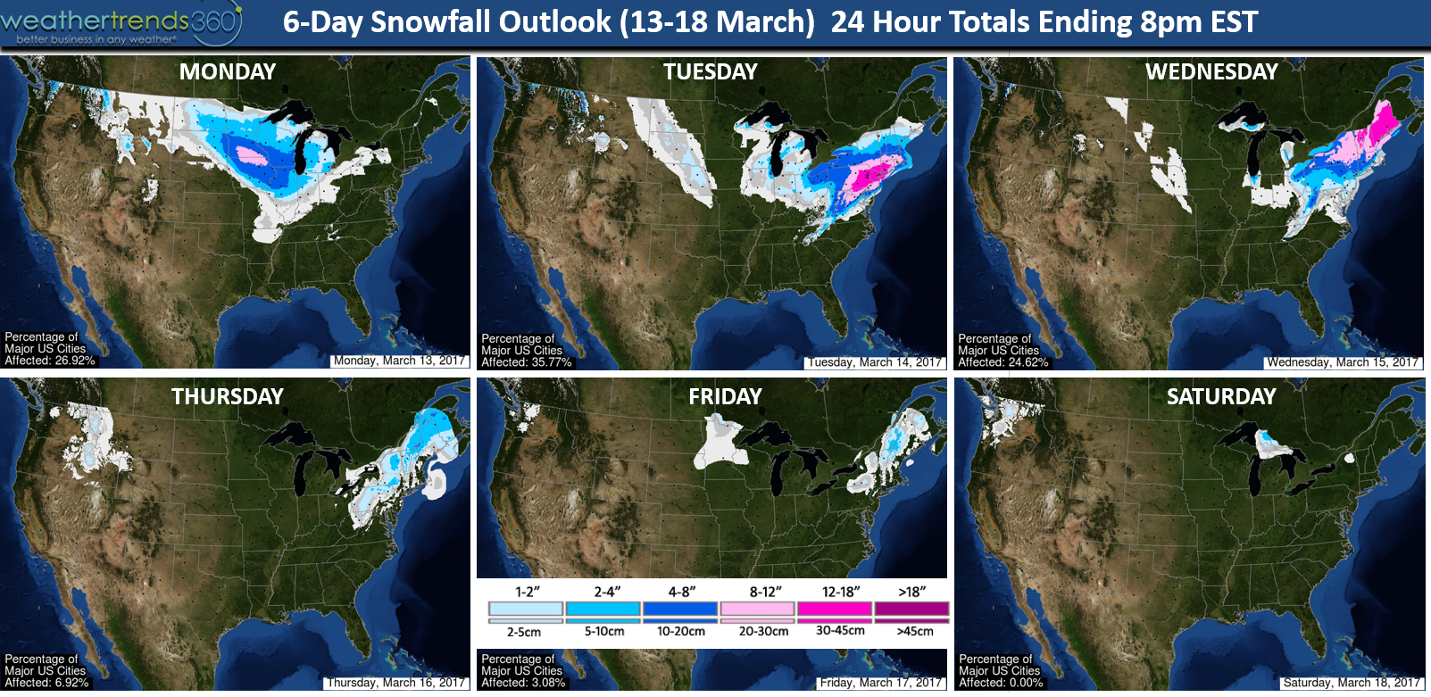
Short range computer models have been predicting this storm for almost a week now with not a whole lot of changes...so an A+ for the general consensus on a major Nor'easter. Of course anyone that's followed wt360 knows we said a year ago that statistics and 24 climate cycles all pointed toward a cold and snowy Northeast March, wholesale change from last years near record warm March and we're getting that big time! March in the Northeast will be the snowiest in 24+ years and possibly set a 121 year record when all is said and done. There are times when models offer different solutions, they really don't with this one, and that's when you just need to keyin on a few fundamental factors to get the most likely outcome and this one is classic meteorology 101 - Arctic air in place, frigid high pressure with a High over Low pattern, blocking high pressure in the Atlantic and Gulf of Mexico moisture source and an event starting at night - allows accumulations to get off to a heavy start minimizing the impact of daytime high sun angle here in March....so this one has it all.
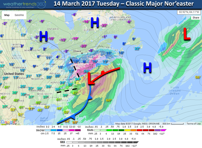
The snow starts tonight in the Southern Northeast region, ends Tuesday evening but continuing into Wednesday for New England. There is no doubt this is a major Nor'easter with widespread 12-18"+ totals and yes some models show totals as high as 29" North and West of I-95. Those extreme record breaking totals are only possible for those that get into what's called a back end deformation band of snow - most likely in PA and Southern NY. Models do show periods of heavy snow late tonight and tomorrow that could approach 4-5" PER HOUR! 6-day snowfall forecast maps below are generally the midpoint or most likely snow totals - yes some could get more, some a little less but a whopper for middle March with parallels to the Storm of the Century 12 March 1993 (24 years ago today). This won't be that strong as that blizzard brought 40" totals to PA, 16" to Alabama, 4" of snow as far south as Florida, 10 million households without power, 100 mph winds to Cuba and sadly 208 deaths. Again, this won't be as bad but a whopper by March standards.

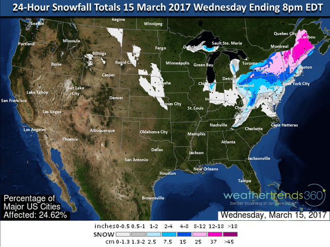
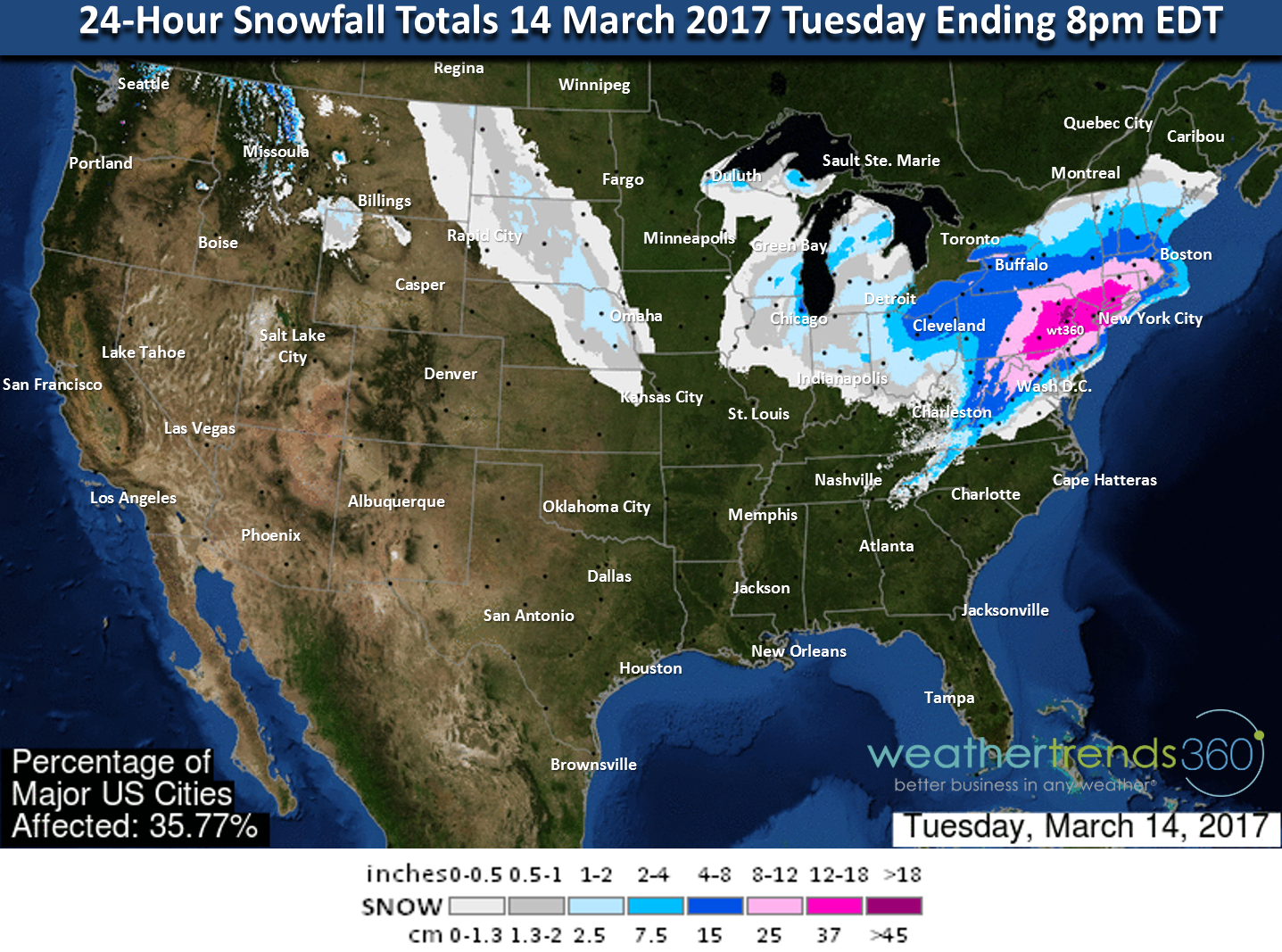
CLOSE UP TUESDAY (24 HR TOTALS)

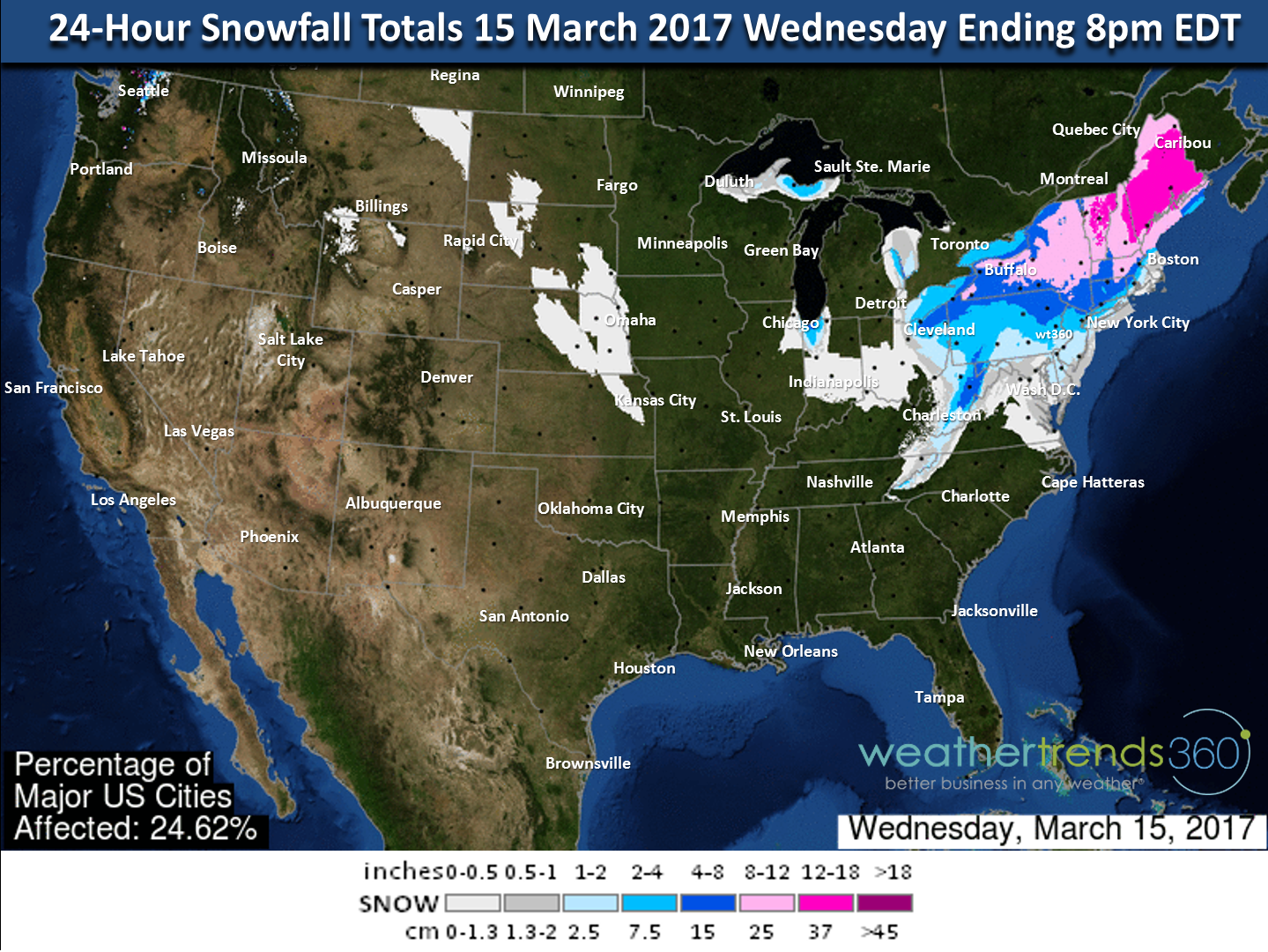
CLOSE UP WEDNESDAY (24 HR TOTALS)
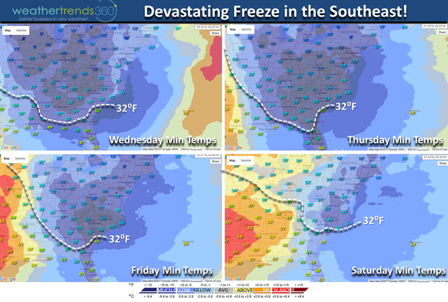
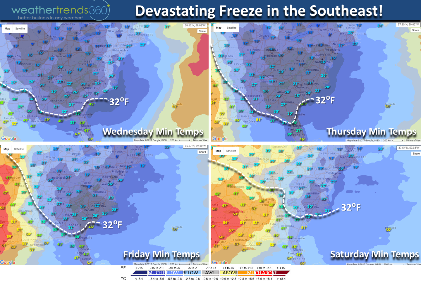
Behind the storm is more devastating impacts with FRIGID ARCTIC AIR invading Deep into the South and really all the way to Florida. With vegetation out 4-5 weeks too early in the South this will be a major devastating freeze for fruit trees, flowers and even some trees. It's not just a quick hit either as we have 3 to 4 nights of hard freezes in the teens and 20s so the prolonged nature is bad news.
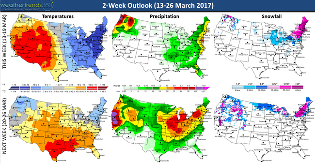
The 2-week outlook shows moderation for the South, but the Northwest and Northeast remain cold and likely more white on the way! California is in for another big storm too.
Finally, I'd like to say HAPPY ANNIVERSARY to my wonderful wife...this time 3 years ago we were enjoying 80F temperatures on a beach in Hawaii where Capt Kirk grew up. :)

Have a great week folks and PLEASE TAKE THIS STORM SERIOUSLY! We will have frequent updates on Facebook and Twitter throughout the storm.
- Capt Kirk out.
Short range computer models have been predicting this storm for almost a week now with not a whole lot of changes...so an A+ for the general consensus on a major Nor'easter. Of course anyone that's followed wt360 knows we said a year ago that statistics and 24 climate cycles all pointed toward a cold and snowy Northeast March, wholesale change from last years near record warm March and we're getting that big time! March in the Northeast will be the snowiest in 24+ years and possibly set a 121 year record when all is said and done. There are times when models offer different solutions, they really don't with this one, and that's when you just need to keyin on a few fundamental factors to get the most likely outcome and this one is classic meteorology 101 - Arctic air in place, frigid high pressure with a High over Low pattern, blocking high pressure in the Atlantic and Gulf of Mexico moisture source and an event starting at night - allows accumulations to get off to a heavy start minimizing the impact of daytime high sun angle here in March....so this one has it all.

The snow starts tonight in the Southern Northeast region, ends Tuesday evening but continuing into Wednesday for New England. There is no doubt this is a major Nor'easter with widespread 12-18"+ totals and yes some models show totals as high as 29" North and West of I-95. Those extreme record breaking totals are only possible for those that get into what's called a back end deformation band of snow - most likely in PA and Southern NY. Models do show periods of heavy snow late tonight and tomorrow that could approach 4-5" PER HOUR! 6-day snowfall forecast maps below are generally the midpoint or most likely snow totals - yes some could get more, some a little less but a whopper for middle March with parallels to the Storm of the Century 12 March 1993 (24 years ago today). This won't be that strong as that blizzard brought 40" totals to PA, 16" to Alabama, 4" of snow as far south as Florida, 10 million households without power, 100 mph winds to Cuba and sadly 208 deaths. Again, this won't be as bad but a whopper by March standards.
CLOSE UP TUESDAY (24 HR TOTALS)
CLOSE UP WEDNESDAY (24 HR TOTALS)
Behind the storm is more devastating impacts with FRIGID ARCTIC AIR invading Deep into the South and really all the way to Florida. With vegetation out 4-5 weeks too early in the South this will be a major devastating freeze for fruit trees, flowers and even some trees. It's not just a quick hit either as we have 3 to 4 nights of hard freezes in the teens and 20s so the prolonged nature is bad news.
The 2-week outlook shows moderation for the South, but the Northwest and Northeast remain cold and likely more white on the way! California is in for another big storm too.

Finally, I'd like to say HAPPY ANNIVERSARY to my wonderful wife...this time 3 years ago we were enjoying 80F temperatures on a beach in Hawaii where Capt Kirk grew up. :)

Have a great week folks and PLEASE TAKE THIS STORM SERIOUSLY! We will have frequent updates on Facebook and Twitter throughout the storm.
- Capt Kirk out.