Star Date 18 Sept 2017 Monday
Captain's Log
Happy Monday.
The tropics are clearly living up to climatology which indicates middle September is the peak of the hurricane season. Fortunately it appears the 3 systems in the Atlantic will miss the U.S. East Coast, but not so for the U.S. Virgin Islands and Puerto Rico. Unlike IRMA, soon to be Major cat 4 Hurricane Maria looks to take a southern track right through the U.S. Virgin Islands and Northeast Puerto Rico Tuesday and Wednesday this week. This will be a devastating hurricane for these regions that weren't hit as hard as the British Virgin Islands. CLICK ON IMAGES FOR LARGER VIEW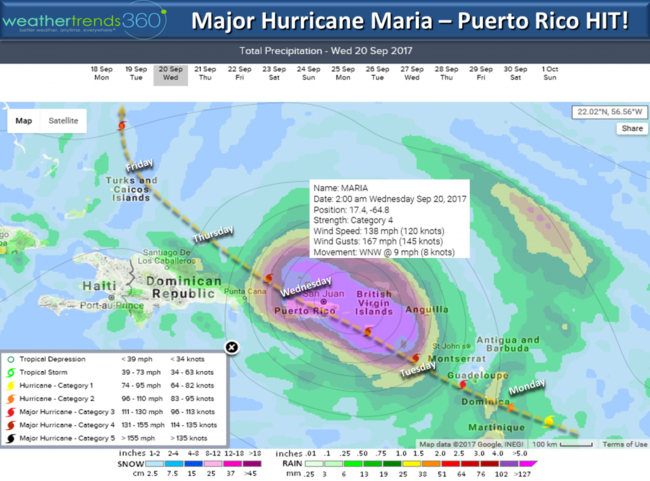

Minimal hurricane Jose will weaken to a tropical storm and likely do one more loop around before heading Northeast away from the U.S. Very unlikely Jose has any impact on U.S. other than some larger 9-12 foot waves from NJ to Cape Cod with some beach erosion. Lee out in the Atlantic will likely dissipate.
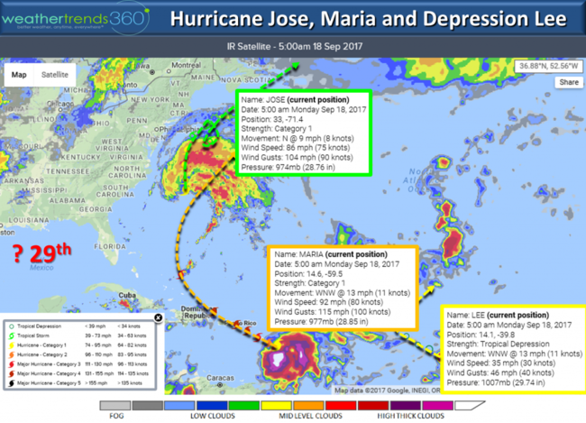
Way out there models hint at a tropical system for the Gulf of Mexico around the 29th - way out there and likely to change.
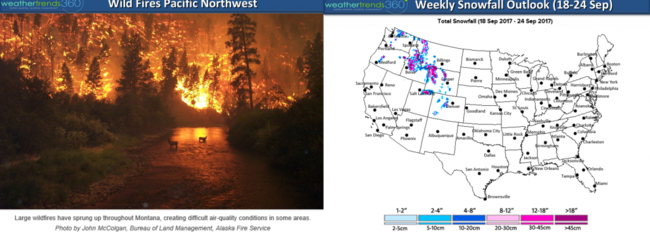
The East has already had several major cold snaps in late August and early September but now the West will get their first taste of Fall. A very strong cold front will move through early this week in the West ushering in a huge drop in temperatures. Some areas will have a 60ºF drop from the near 100ºF heat just a couple weeks ago to upper 30ºs for lows and YES...SNOW! The snow and cold will certainly help get the wild fires under control if not completely put them out!
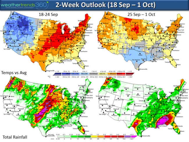
The Central states will heatup in advance of this strong cold front with potentially strong thunderstorms late this week and weekend in the Plains and Midwest.
According to the Sun, Fall officially arrives Friday 22 September 4:02 pm EDT. According to meteorologists, Summer ended on 31 August with June-August considered Summer and 1 Sept - 30 Nov considered Fall.
Have a great week! - Capt Kirk out.
The tropics are clearly living up to climatology which indicates middle September is the peak of the hurricane season. Fortunately it appears the 3 systems in the Atlantic will miss the U.S. East Coast, but not so for the U.S. Virgin Islands and Puerto Rico. Unlike IRMA, soon to be Major cat 4 Hurricane Maria looks to take a southern track right through the U.S. Virgin Islands and Northeast Puerto Rico Tuesday and Wednesday this week. This will be a devastating hurricane for these regions that weren't hit as hard as the British Virgin Islands. CLICK ON IMAGES FOR LARGER VIEW
Minimal hurricane Jose will weaken to a tropical storm and likely do one more loop around before heading Northeast away from the U.S. Very unlikely Jose has any impact on U.S. other than some larger 9-12 foot waves from NJ to Cape Cod with some beach erosion. Lee out in the Atlantic will likely dissipate.

Way out there models hint at a tropical system for the Gulf of Mexico around the 29th - way out there and likely to change.
The East has already had several major cold snaps in late August and early September but now the West will get their first taste of Fall. A very strong cold front will move through early this week in the West ushering in a huge drop in temperatures. Some areas will have a 60ºF drop from the near 100ºF heat just a couple weeks ago to upper 30ºs for lows and YES...SNOW! The snow and cold will certainly help get the wild fires under control if not completely put them out!
The Central states will heatup in advance of this strong cold front with potentially strong thunderstorms late this week and weekend in the Plains and Midwest.

According to the Sun, Fall officially arrives Friday 22 September 4:02 pm EDT. According to meteorologists, Summer ended on 31 August with June-August considered Summer and 1 Sept - 30 Nov considered Fall.
Have a great week! - Capt Kirk out.