14 Mar '26 Weather Brief: Summer in the Southwest, Winter in the North Central and Northeast States
Captain's Log
No video this week as the Captain has retreated to warmer climates. He'll be back next week just in time for the return of the Polar Vortex!
We have less than a week until the astronomical calendar says it's Spring (20 Mar '26 10:46 EDT), unfortunately, the weather won't be cooperating in the Great Lakes and Northeast with a colder and snowier pattern afoot. More on that below.
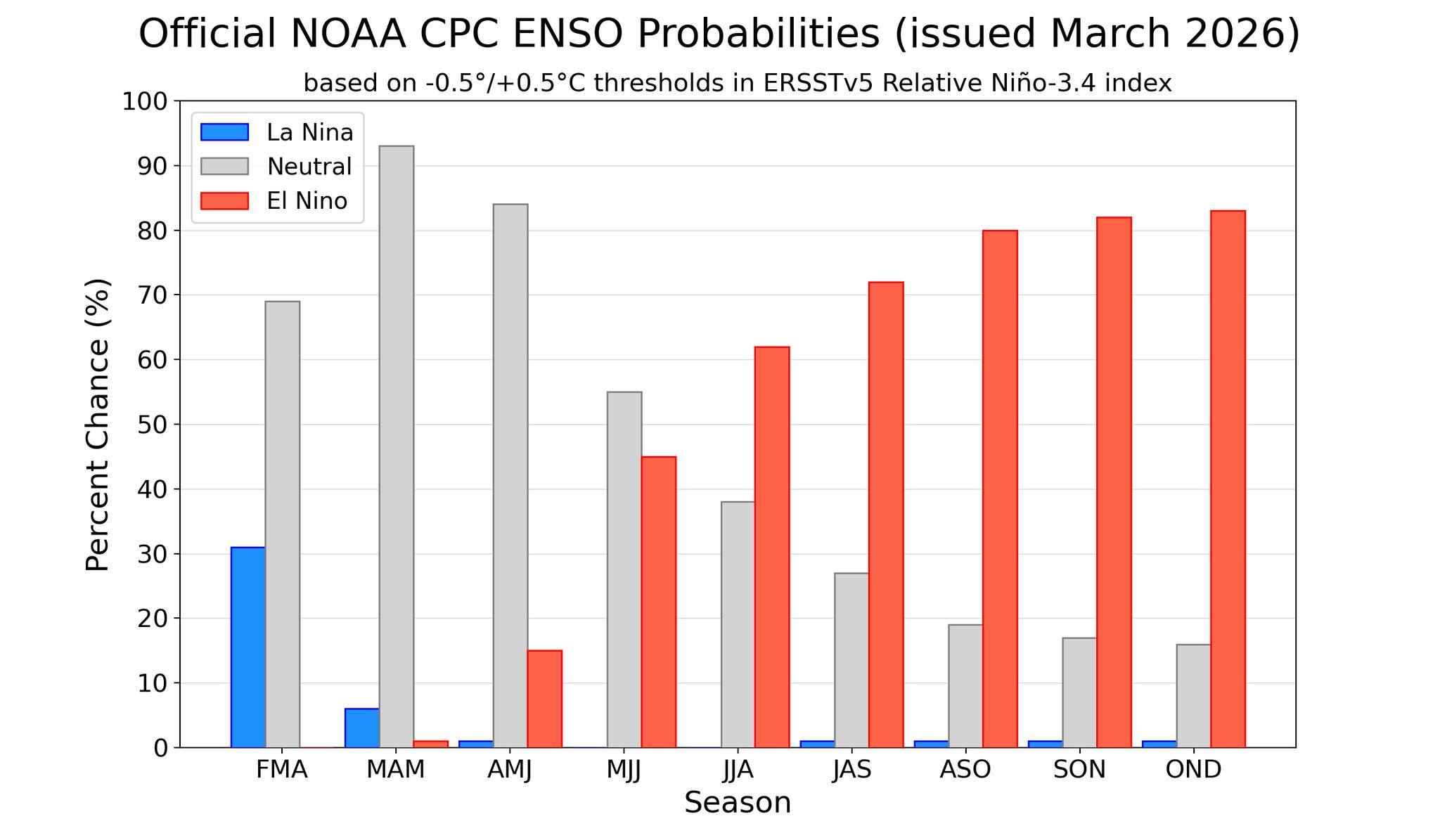
As we discussed last week, El Niño is becoming the buzz word this Spring. Forecasts continue to show a strong probability for El Niño by Summer and continuing through the end of the year. NOAA has issued an "El Niño Watch". With the potential for a strong Niño later this year, this will have a significant impact to the weather pattern in the year ahead.

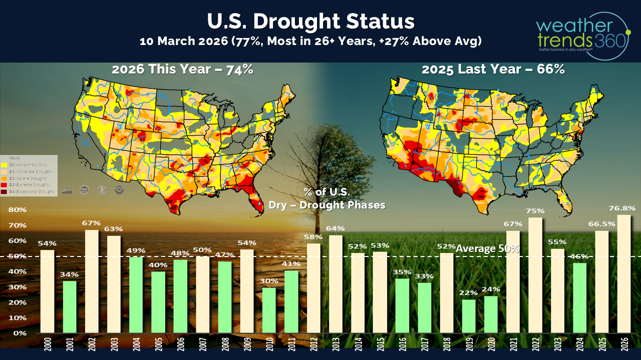
One major benefit will be drought-busting rainfall as we go through Summer and Fall this year. Currently 77% of the U.S. is in dry to drought phases, the most in 26 years, but this is likely to plummet in most of the U.S. as a WET pattern develops by Fall 2026.

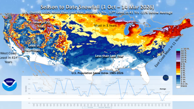
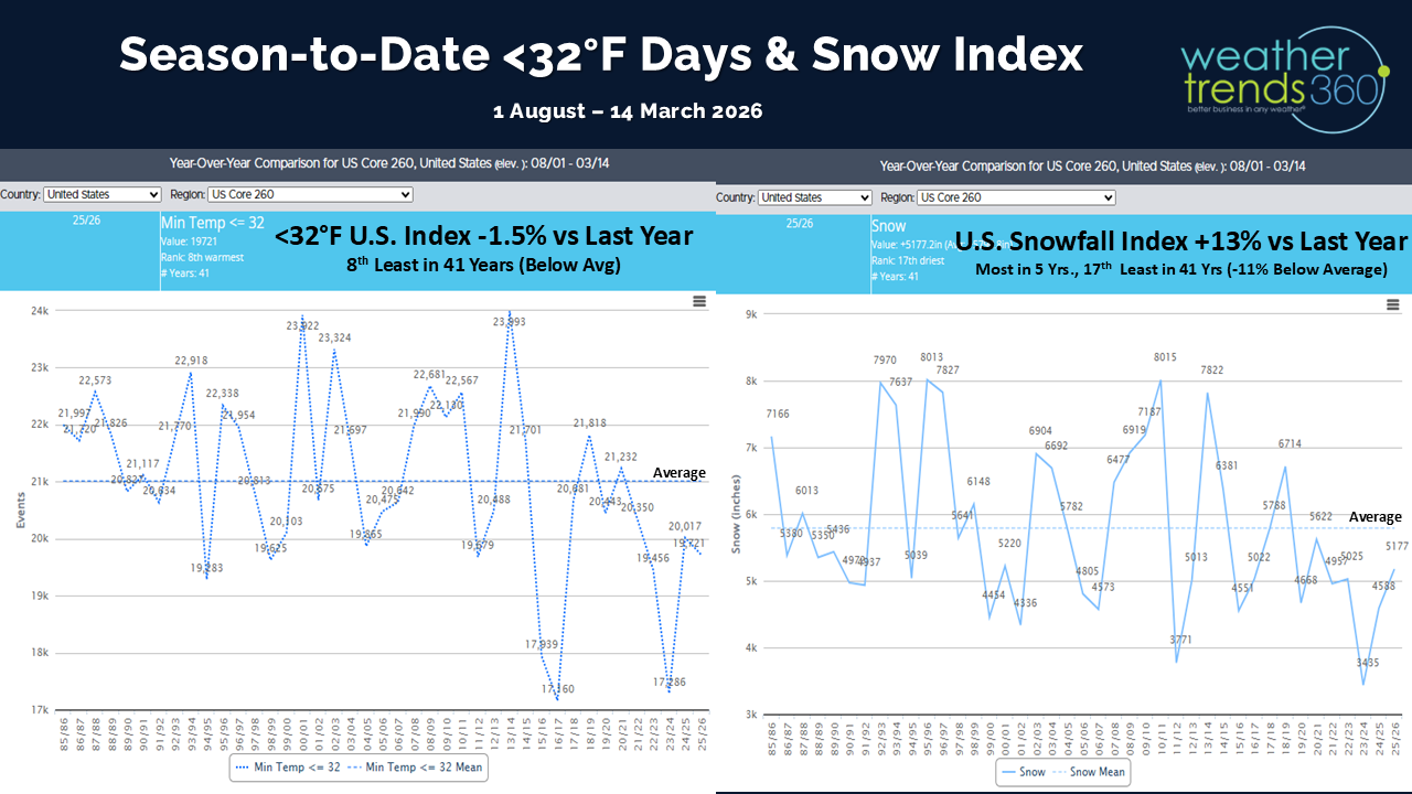
U.S. Season-to-date snowfall continues to show the East with the most snow in 11 years, while the West is the least in over 41 years. The U.S. overall trends 12% snowier vs last year with the most snow in 5 years. We'll add to these totals over the next week as Winter makes a vicious return to the North Central and Northeast states.
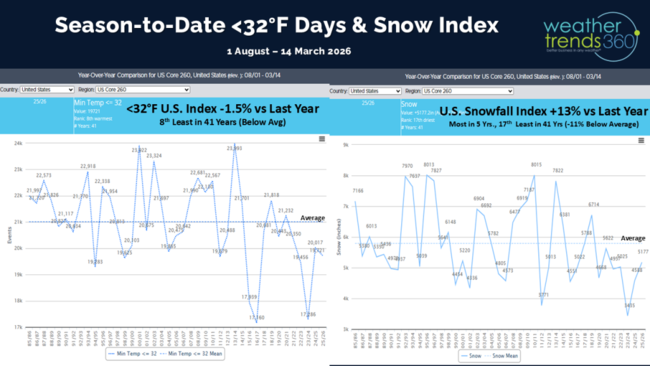
The U.S. cold days index dropped a little bit more below last year and is the 8th least in 41 years for August through mid March.
Last week (8-14 March) across the World shows the U.S. trending +0.9F warmer than last year, the warmest in 10 years and 3rd warmest in 41 years. Snowfall was up +546%, the most in 3 years and the 17th most in 41 years, while rainfall was up 47% vs LY and the 15th most in 41 years. Exceptional warmth developed in the Desert Southwest and southern California where this was the 3rd warmest second week of March in 41 years. In fact, portions of southern California were under a heat advisory with temperatures soaring into the upper 80s and 90s. This was much hotter than last year and will have driven significant year-on-year increases in sales of cold beverages, sun care, warm weather apparel, ice cream and even fans/air conditioners.
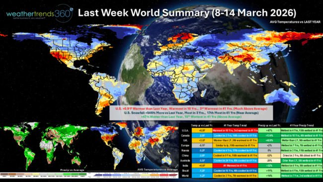
The East Coast also saw a surge of much warmer weather, even though it was brief. Despite the return of much colder weather in the second half of the week, the second week of March overall trended the 2nd-3rd warmest in 41 years on the East Coast.
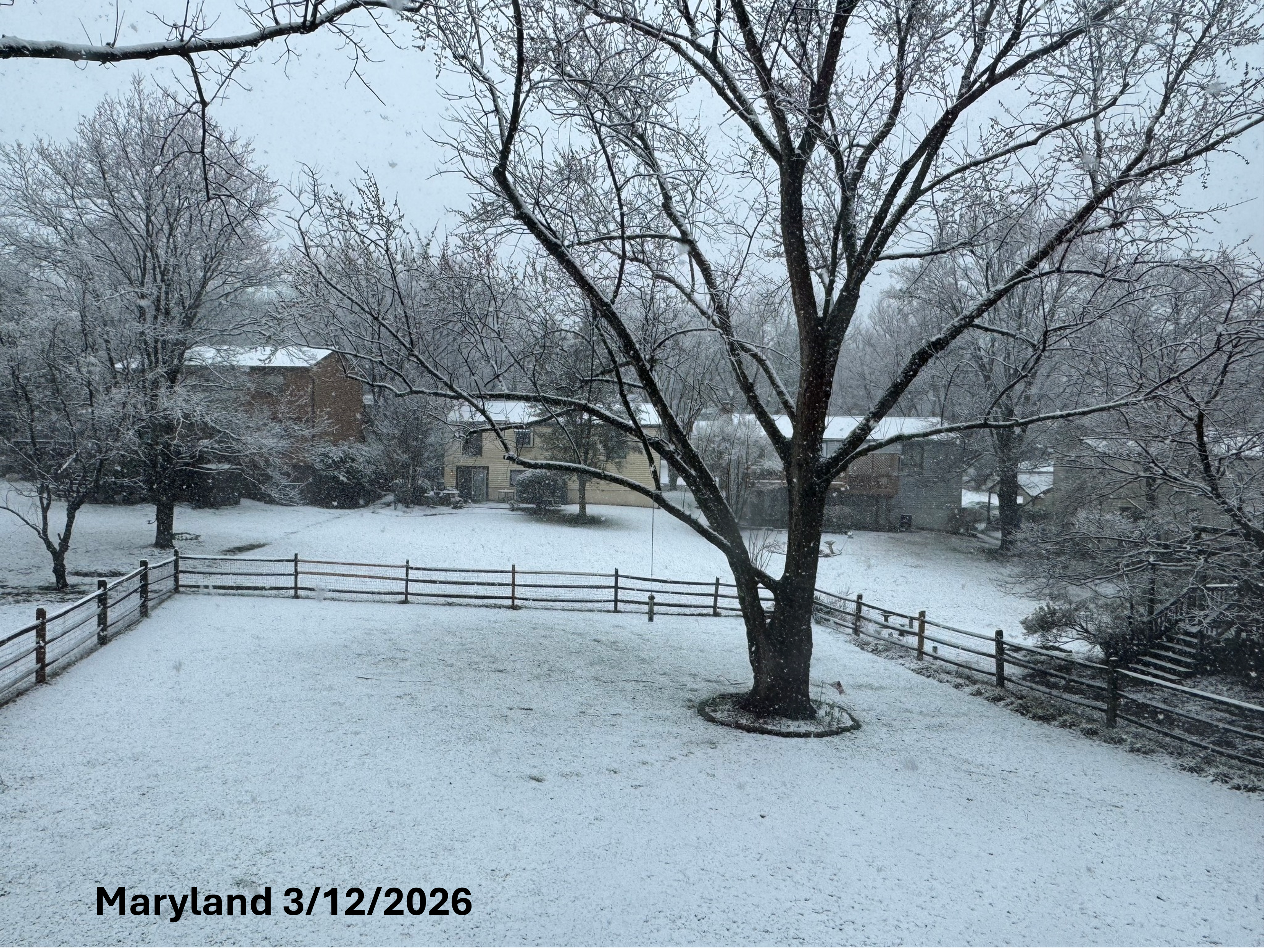
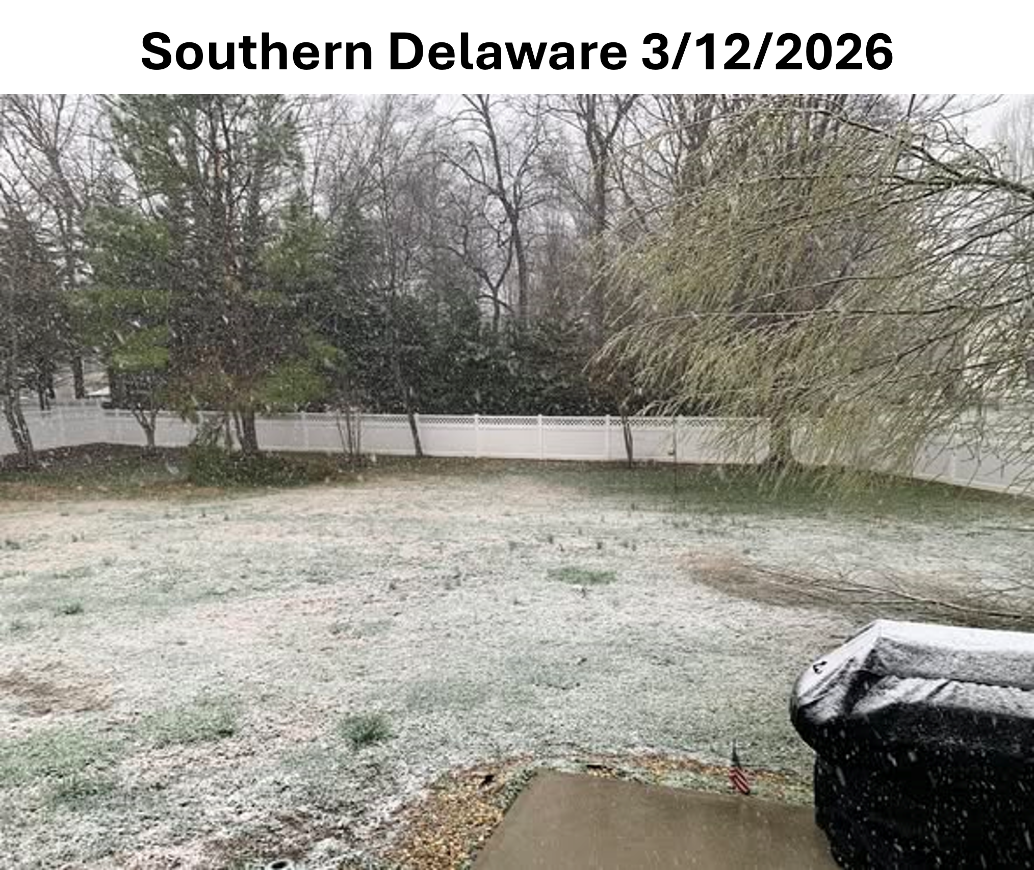
Temperatures soared into the 80s in the middle of the week setting records for some cities in the Northeast but a vigorous cold front swept through by Thursday bringing a coating of snow to some places, including in Maryland and even southern Delaware; pictures below were taken of the snow on Thursday, March 12, 2026.


A winter storm moved through the Upper Midwest and Great Lakes late in the week and was a precursor to a major winter storm that will move through later this weekend.
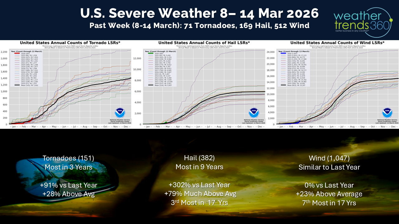
Accompanying the drastic changes in temperature came an uptick in severe weather activity which, sadly, brought the first deadly tornadoes of the season to the Midwest and central Plains. Severe weather activity for the year-to-date after this week now ticks slightly above the average.

Meanwhile, in the land down under, this was a much colder second week of March compared to last year's 1st warmest; this year was the coldest in 24 years and the 8th coldest second week of March in 41 years for Australia as a whole. In Europe, this was the 10th warmest second week of March in 41 years with a split in year-on-year temperature trends as northern, central, and western Europe all trended warmer, while southeastern Europe was much colder. Brazil trended the 4th coolest and 15th wettest in 41 years for the second week of March and the coolest in 15 years. More heavy rains fell causing further flood issues in states like Minas Gerais. Flooding also impacted portions of eastern and southern Africa with Ethiopia and Kenya being hit particularly hard by flash floods and landslides.
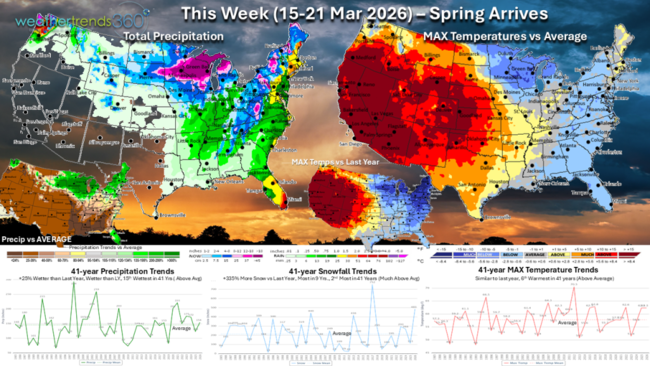
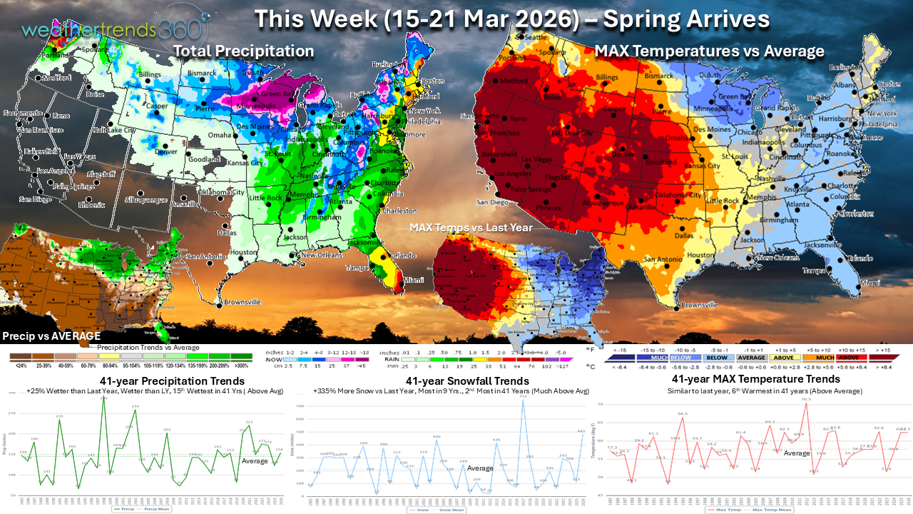
This week (15-21 Mar) shows a large portion of the western U.S. with much above average temperatures and temperatures will be exceptionally warmer compared to last year. This will be one of the warmest third weeks of March in 41 years across the western half of the U.S. The unusual early season heat wave will continue in southern California and the Desert Southwest with daytime highs ranging from the 80s to 90s and triple digits for the desert locations. Dry conditions will accompany the warmth across the Southwest, Southern Rockies, and into the High Plains increasing the wildfire risk.
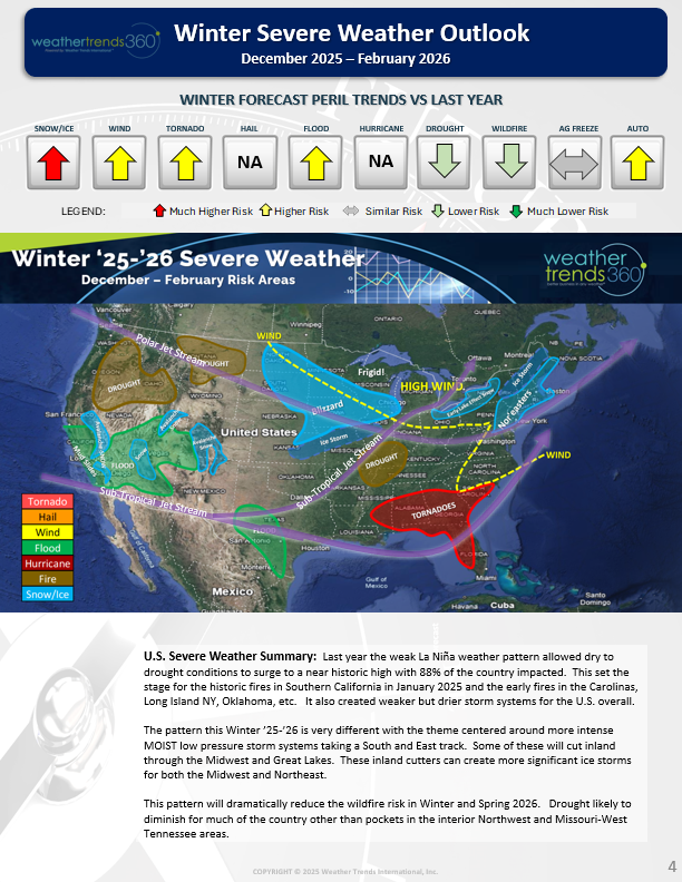
The increased wildfire risk was highlighted nearly a year ago in our "Spring 2026 Severe Weather Outlook". This report highlights long-range peril outlooks for each season including outlooks on tornadoes, severe wind events, hail, hurricanes, drought, wildfire risks and more across the U.S. and globe. It's no secret that severe weather events have a major impact on businesses every year; now you can plan for these events months ahead. Below is a tiny snippet from our Winter 2025-2026 outlook. For more information on this report, reach out to sales@wt360.com.
Meanwhile, a totally different story will unfold across the North Central and Northeast states. The week begins with a major winter storm in the Upper Midwest and Great Lakes that is expected to dump widespread 6"+ of snow with localized amounts in the 1-2 foot range. Travel will become nearly impossible on Sunday across parts of the region. Blizzard conditions may also develop Sunday into Monday which will prolong impacts after the snow ends on Monday. The best chance of over a foot of snow will be just near the Twin Cities in Minnesota and eastward across central Wisconsin to the Upper Peninsula of Michigan. This powerful storm will sweep a cold front across the East on Monday with rain possibly changing to snow across the Midwest and Northeast as well as another round of severe weather in the Midwest and Mississippi Valley and along the East Coast.
Behind this storm, a lobe of the Polar Vortex displaces Arctic air and sends it plummeting southward across the Central U.S. and East. Temperatures will struggle to get out of the 30s with overnight lows well below freezing for much of the Northeast. Sub-zero temperatures in the Northern Plains will bring a harsh Winter reality check. Temperatures will moderate later in the week, though the Northeast may remain colder than normal. Compared to a warm mid-March last year, the Northeast will trend much colder this year. As the temperatures tumble, so too will the demand for Spring seasonal categories.
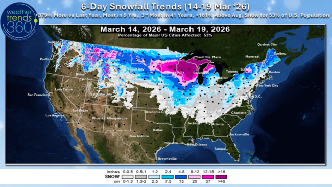
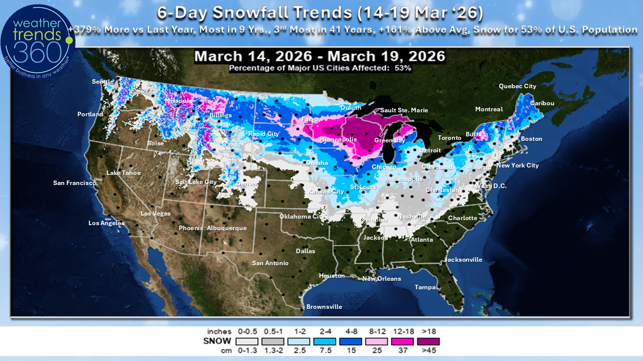
The 6-day snowfall outlook (14-19 Mar) shows 53% of the U.S. getting some snow with +379% more than last year, the most in 9 years and the 3rd snowiest in 41 years.
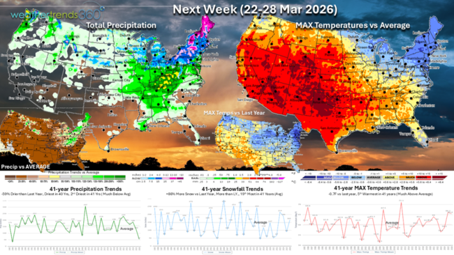
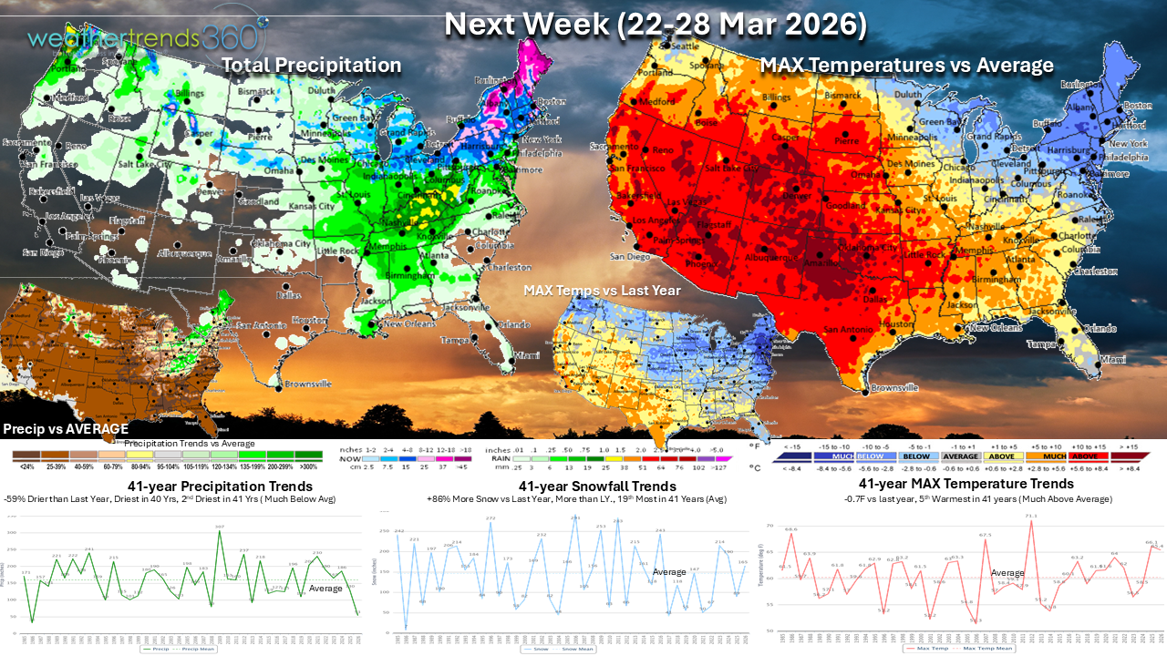
Next Week (22-28 Mar) shows some temporary moderation in temperatures across the North Central and Northeast states, but we're eyeing up the later week period for the potential of another surge of much colder air and, dare we say, snow to the region?! Before that, however, warmer temperatures across much of the nation will help to make this the 5th warmest fourth week of March in 41 years for the U.S. as a whole. Hotter weather continues in the Southwest. Heat expands and intensifies for a time in the South Central states and this will be one of the warmest fourth weeks of March in 41 years for the Southwest and South Central states.
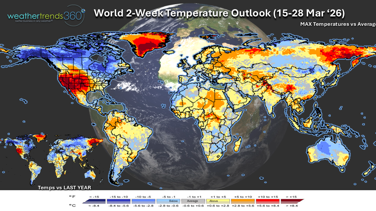
The 2-week World Temperature outlook (15-28 Mar) shows the extreme warmth in the Southwest spilling over into the Rockies and High Plains. Meanwhile, our neighbors to the north in Canada will be affected by some of the same Arctic surges and this is forecast to the coldest second half of March in 3 years for the country as a whole.

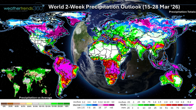
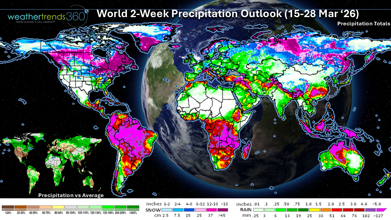
Unfortunately, the 2-week World Precipitation outlook (15-28 Mar) shows that the wetter weather pattern continues in parts of Africa where flooding has been an issue lately and this could be one of the wettest second halves of March in over 40 years for these countries. Flood risks will continue in eastern and southern Africa. Wetter trends also look to prevail across many of the major growing regions in Brazil.
You can get this blog/video in your email inbox every Saturday (FREE) via subscription.
Have a great week ahead, and don't forget to follow us on social media for updates: Facebook, Twitter(X), YouTube, Pinterest and Linkedin.
-Meteorologist Krissy
We have less than a week until the astronomical calendar says it's Spring (20 Mar '26 10:46 EDT), unfortunately, the weather won't be cooperating in the Great Lakes and Northeast with a colder and snowier pattern afoot. More on that below.
As we discussed last week, El Niño is becoming the buzz word this Spring. Forecasts continue to show a strong probability for El Niño by Summer and continuing through the end of the year. NOAA has issued an "El Niño Watch". With the potential for a strong Niño later this year, this will have a significant impact to the weather pattern in the year ahead.
One major benefit will be drought-busting rainfall as we go through Summer and Fall this year. Currently 77% of the U.S. is in dry to drought phases, the most in 26 years, but this is likely to plummet in most of the U.S. as a WET pattern develops by Fall 2026.
U.S. Season-to-date snowfall continues to show the East with the most snow in 11 years, while the West is the least in over 41 years. The U.S. overall trends 12% snowier vs last year with the most snow in 5 years. We'll add to these totals over the next week as Winter makes a vicious return to the North Central and Northeast states.

The U.S. cold days index dropped a little bit more below last year and is the 8th least in 41 years for August through mid March.
Last week (8-14 March) across the World shows the U.S. trending +0.9F warmer than last year, the warmest in 10 years and 3rd warmest in 41 years. Snowfall was up +546%, the most in 3 years and the 17th most in 41 years, while rainfall was up 47% vs LY and the 15th most in 41 years. Exceptional warmth developed in the Desert Southwest and southern California where this was the 3rd warmest second week of March in 41 years. In fact, portions of southern California were under a heat advisory with temperatures soaring into the upper 80s and 90s. This was much hotter than last year and will have driven significant year-on-year increases in sales of cold beverages, sun care, warm weather apparel, ice cream and even fans/air conditioners.

The East Coast also saw a surge of much warmer weather, even though it was brief. Despite the return of much colder weather in the second half of the week, the second week of March overall trended the 2nd-3rd warmest in 41 years on the East Coast.
Temperatures soared into the 80s in the middle of the week setting records for some cities in the Northeast but a vigorous cold front swept through by Thursday bringing a coating of snow to some places, including in Maryland and even southern Delaware; pictures below were taken of the snow on Thursday, March 12, 2026.
A winter storm moved through the Upper Midwest and Great Lakes late in the week and was a precursor to a major winter storm that will move through later this weekend.
Accompanying the drastic changes in temperature came an uptick in severe weather activity which, sadly, brought the first deadly tornadoes of the season to the Midwest and central Plains. Severe weather activity for the year-to-date after this week now ticks slightly above the average.
Meanwhile, in the land down under, this was a much colder second week of March compared to last year's 1st warmest; this year was the coldest in 24 years and the 8th coldest second week of March in 41 years for Australia as a whole. In Europe, this was the 10th warmest second week of March in 41 years with a split in year-on-year temperature trends as northern, central, and western Europe all trended warmer, while southeastern Europe was much colder. Brazil trended the 4th coolest and 15th wettest in 41 years for the second week of March and the coolest in 15 years. More heavy rains fell causing further flood issues in states like Minas Gerais. Flooding also impacted portions of eastern and southern Africa with Ethiopia and Kenya being hit particularly hard by flash floods and landslides.
This week (15-21 Mar) shows a large portion of the western U.S. with much above average temperatures and temperatures will be exceptionally warmer compared to last year. This will be one of the warmest third weeks of March in 41 years across the western half of the U.S. The unusual early season heat wave will continue in southern California and the Desert Southwest with daytime highs ranging from the 80s to 90s and triple digits for the desert locations. Dry conditions will accompany the warmth across the Southwest, Southern Rockies, and into the High Plains increasing the wildfire risk.
The increased wildfire risk was highlighted nearly a year ago in our "Spring 2026 Severe Weather Outlook". This report highlights long-range peril outlooks for each season including outlooks on tornadoes, severe wind events, hail, hurricanes, drought, wildfire risks and more across the U.S. and globe. It's no secret that severe weather events have a major impact on businesses every year; now you can plan for these events months ahead. Below is a tiny snippet from our Winter 2025-2026 outlook. For more information on this report, reach out to sales@wt360.com.
Meanwhile, a totally different story will unfold across the North Central and Northeast states. The week begins with a major winter storm in the Upper Midwest and Great Lakes that is expected to dump widespread 6"+ of snow with localized amounts in the 1-2 foot range. Travel will become nearly impossible on Sunday across parts of the region. Blizzard conditions may also develop Sunday into Monday which will prolong impacts after the snow ends on Monday. The best chance of over a foot of snow will be just near the Twin Cities in Minnesota and eastward across central Wisconsin to the Upper Peninsula of Michigan. This powerful storm will sweep a cold front across the East on Monday with rain possibly changing to snow across the Midwest and Northeast as well as another round of severe weather in the Midwest and Mississippi Valley and along the East Coast.
Behind this storm, a lobe of the Polar Vortex displaces Arctic air and sends it plummeting southward across the Central U.S. and East. Temperatures will struggle to get out of the 30s with overnight lows well below freezing for much of the Northeast. Sub-zero temperatures in the Northern Plains will bring a harsh Winter reality check. Temperatures will moderate later in the week, though the Northeast may remain colder than normal. Compared to a warm mid-March last year, the Northeast will trend much colder this year. As the temperatures tumble, so too will the demand for Spring seasonal categories.
The 6-day snowfall outlook (14-19 Mar) shows 53% of the U.S. getting some snow with +379% more than last year, the most in 9 years and the 3rd snowiest in 41 years.
Next Week (22-28 Mar) shows some temporary moderation in temperatures across the North Central and Northeast states, but we're eyeing up the later week period for the potential of another surge of much colder air and, dare we say, snow to the region?! Before that, however, warmer temperatures across much of the nation will help to make this the 5th warmest fourth week of March in 41 years for the U.S. as a whole. Hotter weather continues in the Southwest. Heat expands and intensifies for a time in the South Central states and this will be one of the warmest fourth weeks of March in 41 years for the Southwest and South Central states.
The 2-week World Temperature outlook (15-28 Mar) shows the extreme warmth in the Southwest spilling over into the Rockies and High Plains. Meanwhile, our neighbors to the north in Canada will be affected by some of the same Arctic surges and this is forecast to the coldest second half of March in 3 years for the country as a whole.
Unfortunately, the 2-week World Precipitation outlook (15-28 Mar) shows that the wetter weather pattern continues in parts of Africa where flooding has been an issue lately and this could be one of the wettest second halves of March in over 40 years for these countries. Flood risks will continue in eastern and southern Africa. Wetter trends also look to prevail across many of the major growing regions in Brazil.
You can get this blog/video in your email inbox every Saturday (FREE) via subscription.
Have a great week ahead, and don't forget to follow us on social media for updates: Facebook, Twitter(X), YouTube, Pinterest and Linkedin.
-Meteorologist Krissy