15 Nov '25 Capt Kirk Weather Brief - Latter Half November Warmest in 14, Wettest in 10 Yrs
Captain's Log
15 Nov '25: Happy Saturday! :)
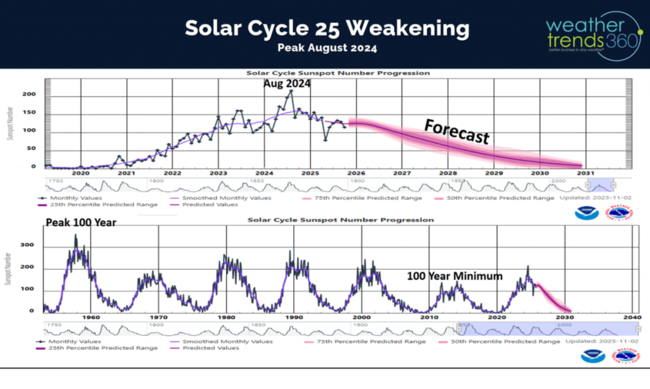
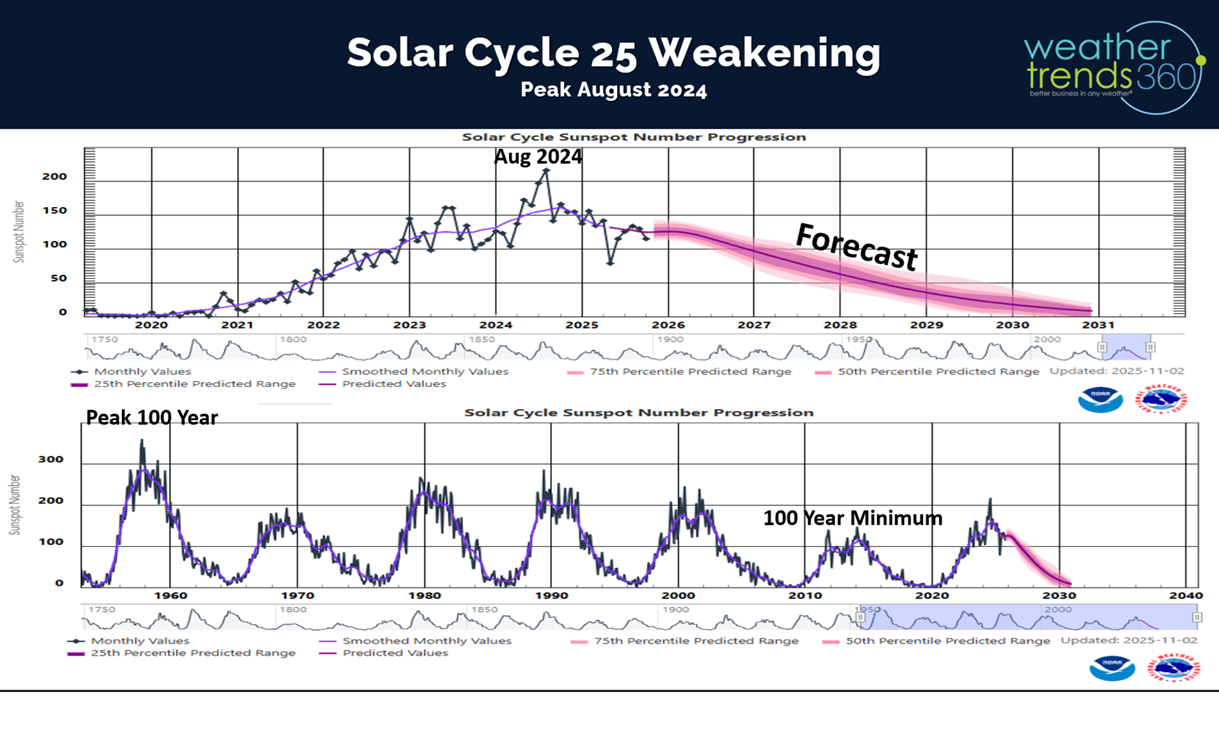
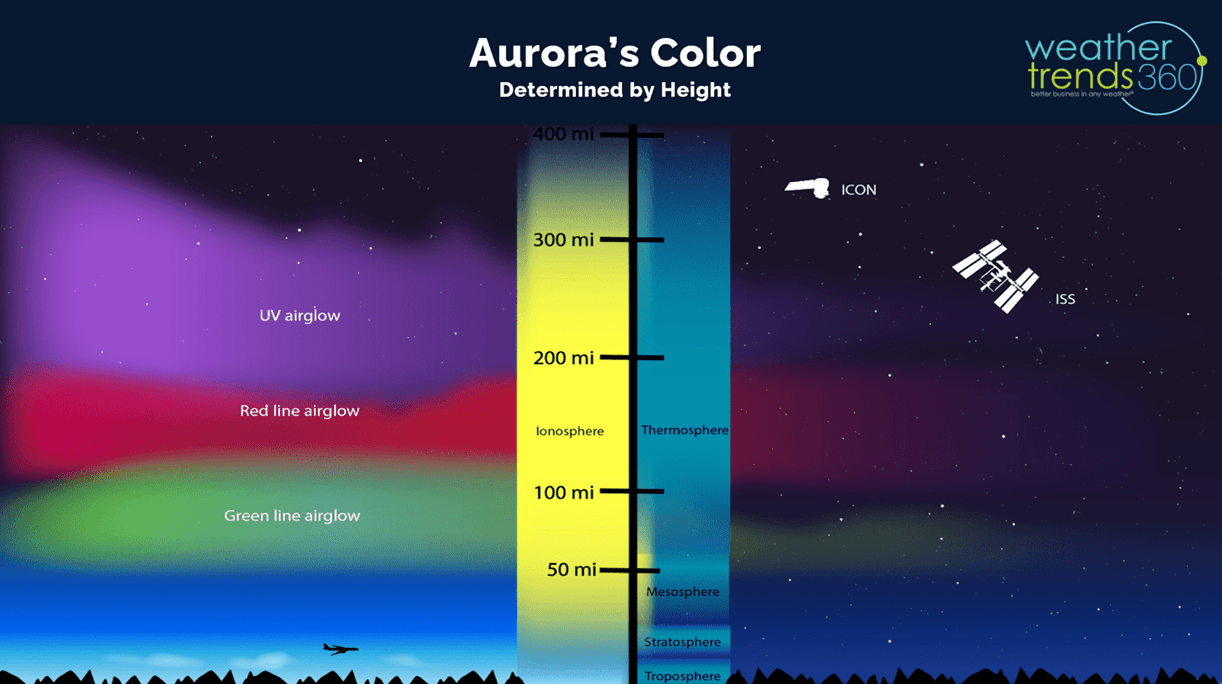
One cycle that has a lagging influence on Earth's weather is the 11-year solar cycle. It peaked in August 2024 and now weakening, but it still sent a severe Geomagnetic Storm this past week bringing Aurora's across the entire U.S. CLICK ON IMAGES FOR A LARGER VIEW
This was the 5th time in the past year that we've seen them here in Eastern PA. This week's Aurora's had all the colors for a spectacular display.

The colors you see are a function of height and where the interaction between the Sun's coronal mass ejection (CME) gets ignited in the Earth's Mesosphere (green Auroras), Ionosphere (Red Auroras) or Thermosphere (Purple Auroras). The event this week had all levels bringing multi-color Auroras.

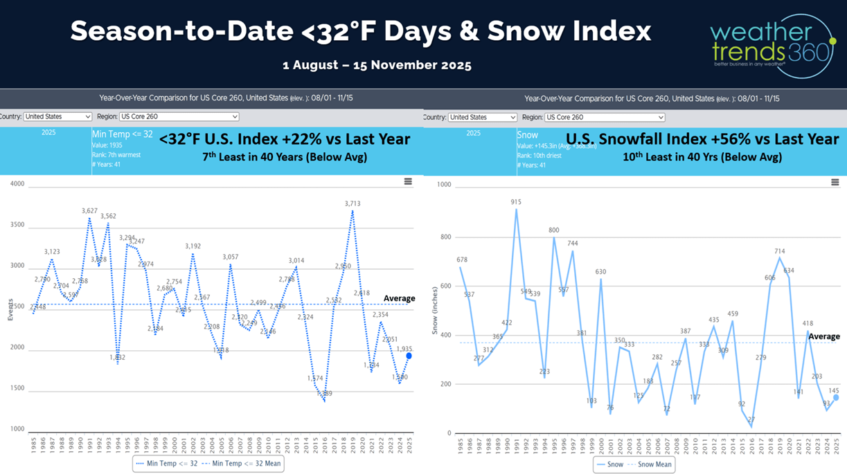
The season's first snows for the Midwest, Great Lakes, Ohio Valley and Northeast had U.S. snow cover at 11.3% of the U.S. with some snow on the ground as of the 11th, the most in 3 years. Much of the natural snow cover in the West has melted.

Season-to-date cold 32F days ticked up and now trending +22% over last year but still 7th least in 40 years, while the U.S. snowfall index is up +56% vs last year and 10th least of the past 40 years.

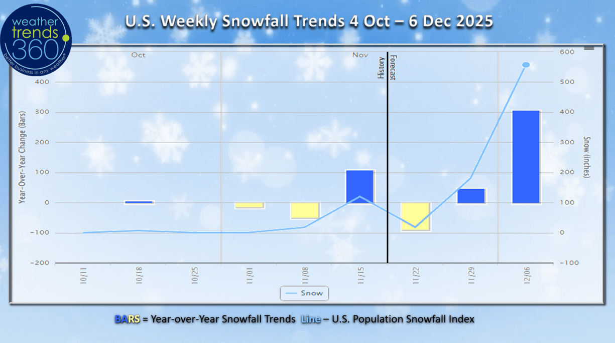
Weekly U.S. snowfall trends show the bigger snowy week this past week, a lull this week and a bigger week of Thanksgiving.
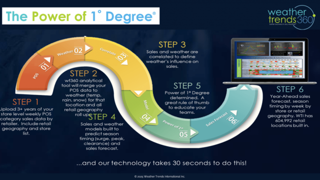
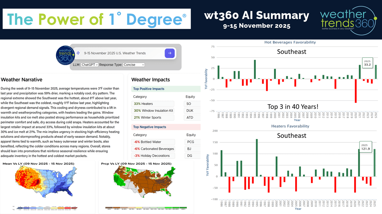
Our Power of 1 Degree YEAR-AHEAD forecasting technology feature today is just a quick wt360 AI summary of the very favorable 2nd week of November for retail and seasonal sales. With record cold deep into the Southeast and Florida, the bigger winner was the portable heating category up +122% vs last year and top 3 of the past 40 years, with hot beverages trending up +33% and also the 3rd best in 40 years for this early start to the season. Areas like Tampa, Florida set all-time record lows with temperatures in the 30s - cold by early November standards.

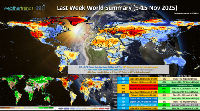
Last week (9-15 Nov) across the World shows the U.S. again trending -2.6F colder than last year, coldest in 6 years and 19th warmest of the past 40 years. Cold 32F days were up +42%, most in 6 years and 21st least in 40 years. Rainfall was down -54% vs last year, driest in 9 years and 7th driest in 40 years. These are favorable trends for Fall seasonal merchandise sales, especially in the Eastern half of the U.S.
Very warm across the U.K. and Europe so unfavorable for Fall sales. Very cold down under in Australia for their Spring season - coldest in 26 years which is unfavorable for Spring merchandise sales.
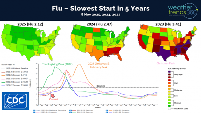
Flu in the U.S. is mirroring the prior Australia season with a very slow start, slowest in 5 years. wt360 is expecting a later peak this year in the February - March timeframe vs last year's Christmas and February peaks and much later than the 2022 season that surged at Thanksgiving. Less Flu is better for the holiday shopping season and store traffic.
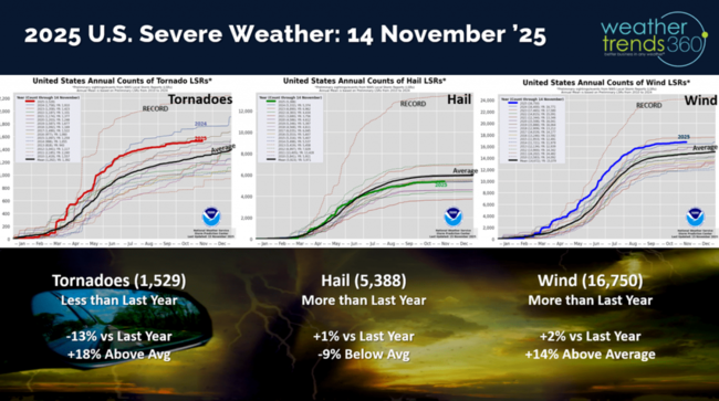
Very little severe weather this past week with year-to-date tornadoes down -13% vs LY, hail +1% and wind cases +2%
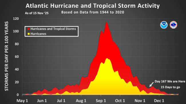
The hurricane season is just about over and there's nothing brewing.
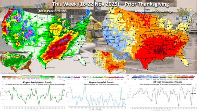
This week (16-22 Nov) shows a moderating trend moving East with the U.S. overall trending +3F warmer than last year and 3rd warmest in 40 years. Snowfall down -65% vs LY and 10th least of the past 40 years, while rainfall is up +1% and wettest in 10 years. Stormy weather for the holiday shopping season is a negative for store traffic and also a big disruptor for travel on airline delays. The Northeast and California still trend cooler than a year ago, which is favorable for seasonal sales.

The 6-day snowfall outlook (15-20 Nov) shows the snowier spots in the high elevations of the West and downwind of the Great Lakes and New England. Snowfall overall down -43% vs last year, 12th least in 40 years with 15% of the U.S. population impacted by some snow.

Next week (23-29 Nov) Thanksgiving shows a strong cold beginning to invade the U.S. that will move off the East Coast over the Thanksgiving holiday. The U.S. overall trends +2.4F warmer than last year and 18th warmest of the past 40 years. Snowfall up +23% vs last year, most in 6 years and 17th most in 40 years, while rainfall is up +57%. This will create some travel headaches in the East and Pacific Northwest.
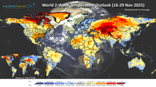
The World 2-week Temperature Outlook (16-29 Nov) shows a generally warmer patter of the U.S. and Canada, while Europe cools down.
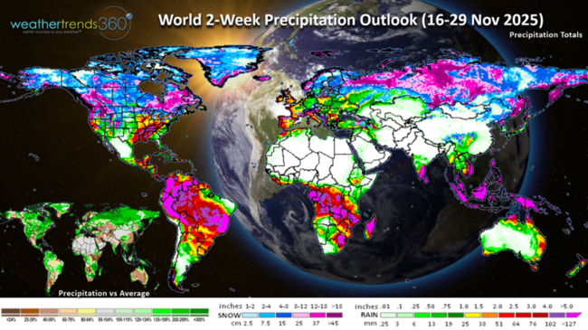
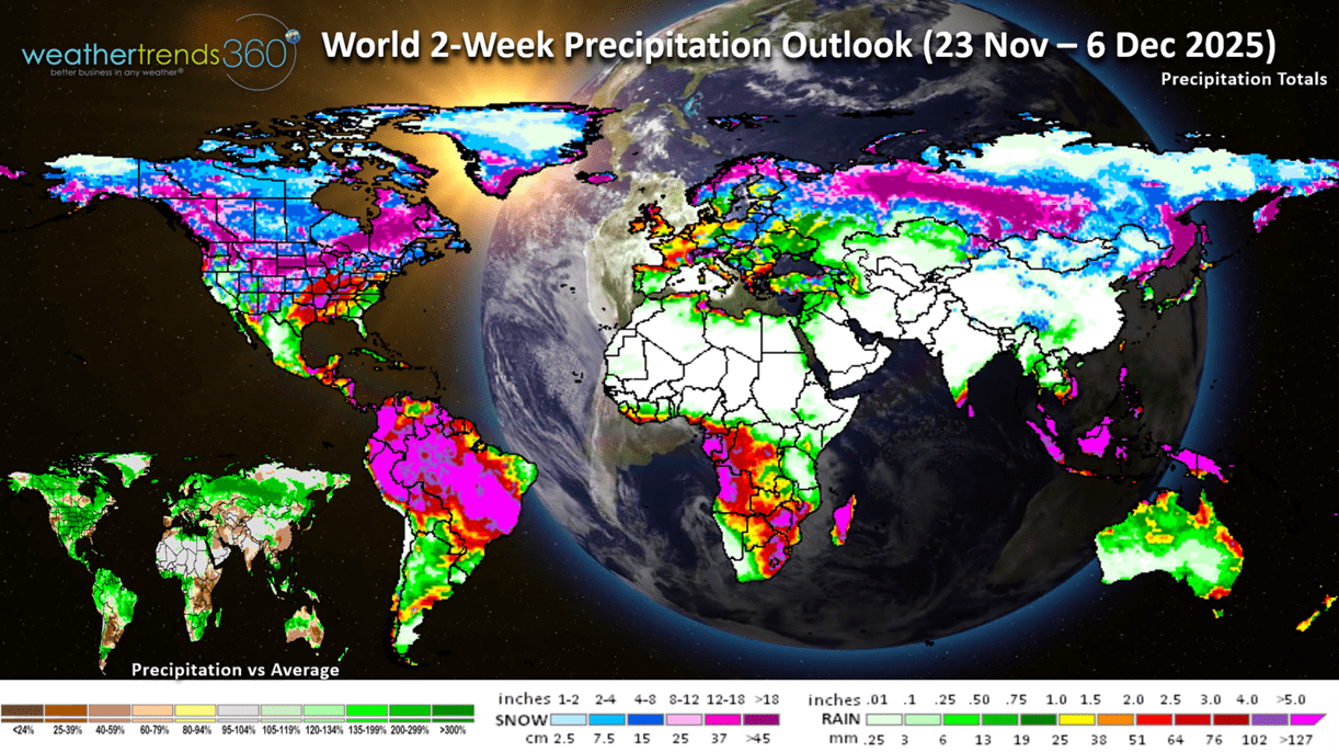
The World 2-week Precipitation Outlook (16-29 Nov) is stormy across the U.S. and Canada.
Don't forget you can now get this blog/video via email as soon as it's released every Saturday. It's a free e-mail subscription for clients and any of our social media fans.
Have a great week ahead, and don't forget to follow us on social media for updates: Facebook, Twitter(X), YouTube, Pinterest and Linkedin.
- Captain Kirk out (USAF Gulf War Veteran 1989-1999)
One cycle that has a lagging influence on Earth's weather is the 11-year solar cycle. It peaked in August 2024 and now weakening, but it still sent a severe Geomagnetic Storm this past week bringing Aurora's across the entire U.S. CLICK ON IMAGES FOR A LARGER VIEW
This was the 5th time in the past year that we've seen them here in Eastern PA. This week's Aurora's had all the colors for a spectacular display.
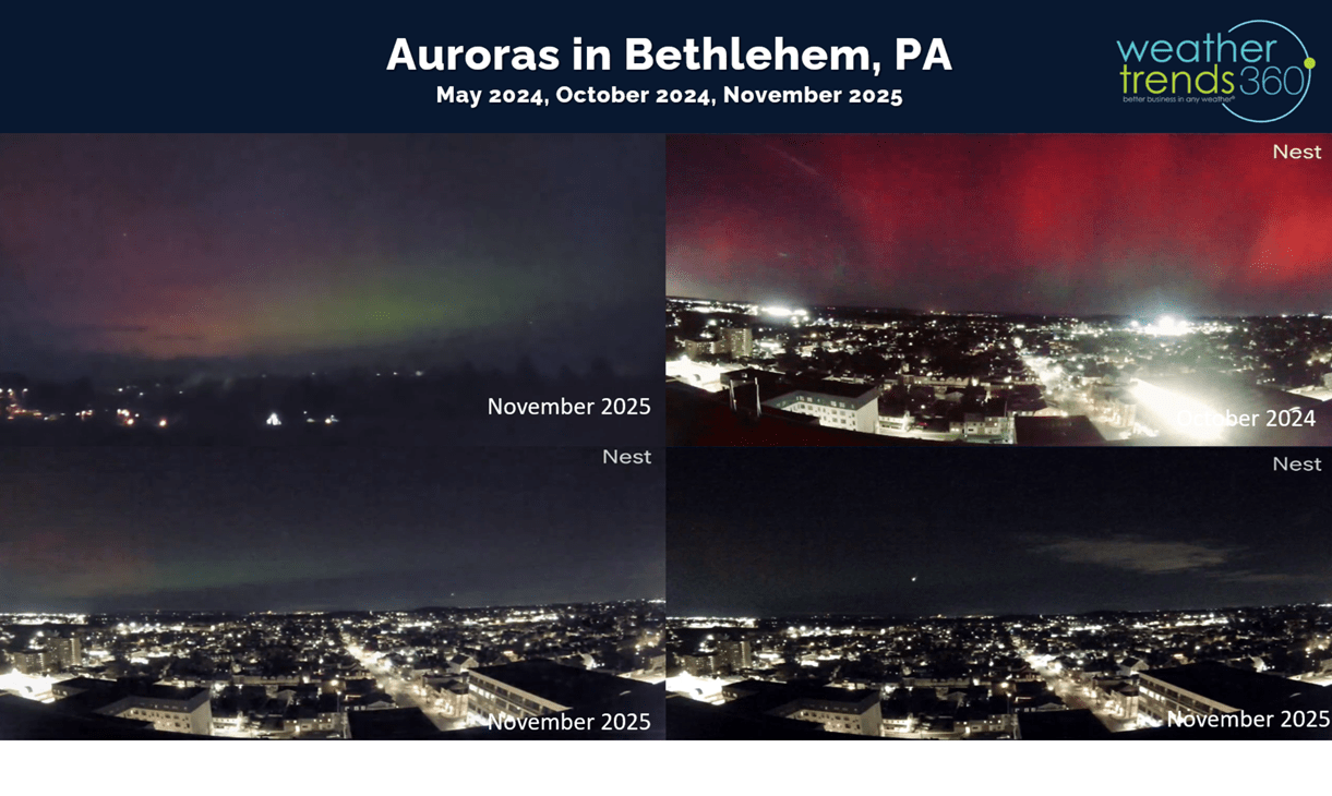
The colors you see are a function of height and where the interaction between the Sun's coronal mass ejection (CME) gets ignited in the Earth's Mesosphere (green Auroras), Ionosphere (Red Auroras) or Thermosphere (Purple Auroras). The event this week had all levels bringing multi-color Auroras.
The season's first snows for the Midwest, Great Lakes, Ohio Valley and Northeast had U.S. snow cover at 11.3% of the U.S. with some snow on the ground as of the 11th, the most in 3 years. Much of the natural snow cover in the West has melted.
Season-to-date cold 32F days ticked up and now trending +22% over last year but still 7th least in 40 years, while the U.S. snowfall index is up +56% vs last year and 10th least of the past 40 years.
Weekly U.S. snowfall trends show the bigger snowy week this past week, a lull this week and a bigger week of Thanksgiving.

Our Power of 1 Degree YEAR-AHEAD forecasting technology feature today is just a quick wt360 AI summary of the very favorable 2nd week of November for retail and seasonal sales. With record cold deep into the Southeast and Florida, the bigger winner was the portable heating category up +122% vs last year and top 3 of the past 40 years, with hot beverages trending up +33% and also the 3rd best in 40 years for this early start to the season. Areas like Tampa, Florida set all-time record lows with temperatures in the 30s - cold by early November standards.
Last week (9-15 Nov) across the World shows the U.S. again trending -2.6F colder than last year, coldest in 6 years and 19th warmest of the past 40 years. Cold 32F days were up +42%, most in 6 years and 21st least in 40 years. Rainfall was down -54% vs last year, driest in 9 years and 7th driest in 40 years. These are favorable trends for Fall seasonal merchandise sales, especially in the Eastern half of the U.S.

Very warm across the U.K. and Europe so unfavorable for Fall sales. Very cold down under in Australia for their Spring season - coldest in 26 years which is unfavorable for Spring merchandise sales.

Flu in the U.S. is mirroring the prior Australia season with a very slow start, slowest in 5 years. wt360 is expecting a later peak this year in the February - March timeframe vs last year's Christmas and February peaks and much later than the 2022 season that surged at Thanksgiving. Less Flu is better for the holiday shopping season and store traffic.
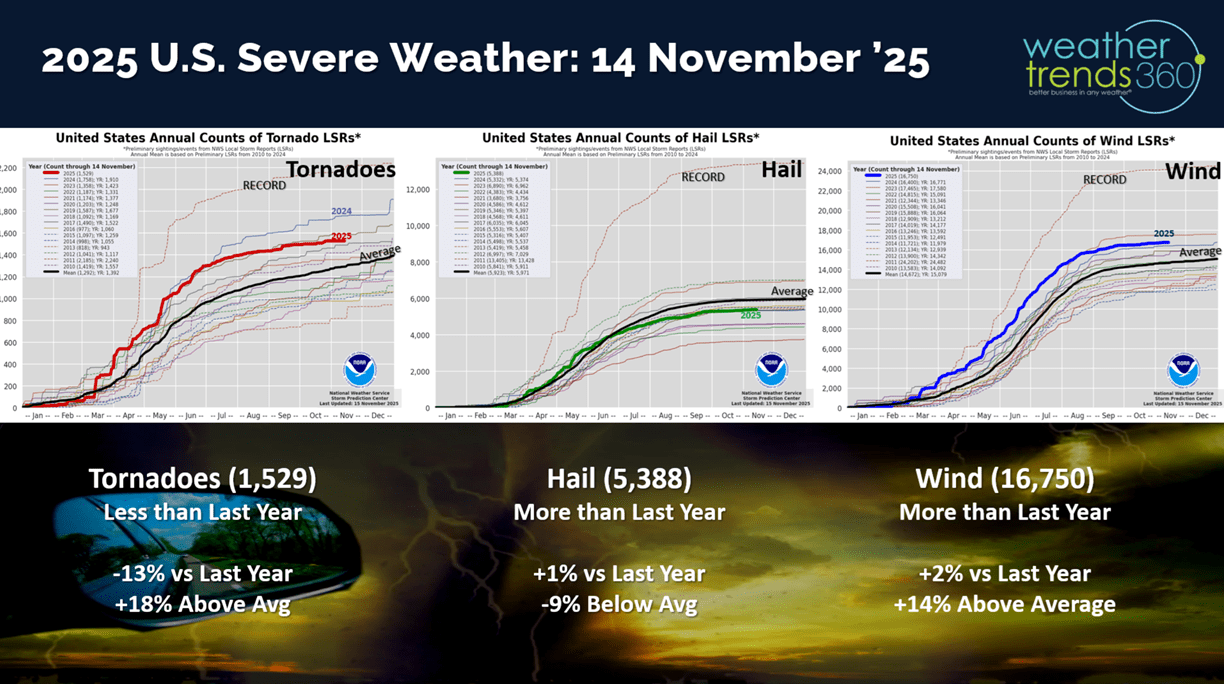
Very little severe weather this past week with year-to-date tornadoes down -13% vs LY, hail +1% and wind cases +2%
The hurricane season is just about over and there's nothing brewing.

This week (16-22 Nov) shows a moderating trend moving East with the U.S. overall trending +3F warmer than last year and 3rd warmest in 40 years. Snowfall down -65% vs LY and 10th least of the past 40 years, while rainfall is up +1% and wettest in 10 years. Stormy weather for the holiday shopping season is a negative for store traffic and also a big disruptor for travel on airline delays. The Northeast and California still trend cooler than a year ago, which is favorable for seasonal sales.

The 6-day snowfall outlook (15-20 Nov) shows the snowier spots in the high elevations of the West and downwind of the Great Lakes and New England. Snowfall overall down -43% vs last year, 12th least in 40 years with 15% of the U.S. population impacted by some snow.

Next week (23-29 Nov) Thanksgiving shows a strong cold beginning to invade the U.S. that will move off the East Coast over the Thanksgiving holiday. The U.S. overall trends +2.4F warmer than last year and 18th warmest of the past 40 years. Snowfall up +23% vs last year, most in 6 years and 17th most in 40 years, while rainfall is up +57%. This will create some travel headaches in the East and Pacific Northwest.

The World 2-week Temperature Outlook (16-29 Nov) shows a generally warmer patter of the U.S. and Canada, while Europe cools down.

The World 2-week Precipitation Outlook (16-29 Nov) is stormy across the U.S. and Canada.
Don't forget you can now get this blog/video via email as soon as it's released every Saturday. It's a free e-mail subscription for clients and any of our social media fans.
Have a great week ahead, and don't forget to follow us on social media for updates: Facebook, Twitter(X), YouTube, Pinterest and Linkedin.
- Captain Kirk out (USAF Gulf War Veteran 1989-1999)