31 May '25 Captain's Blog: Cooler/Wetter Start to Summer
Captain's Log
31 May '25: Happy Saturday! :)
Hard to believe that May is in the history books and the theme was cool and very wet. May 2025 for the U.S. overall was the coolest in 4 years, 19th coolest of the past 40 years with below average national temperatures. CLICK ON IMAGES FOR A LARGER VIEW.
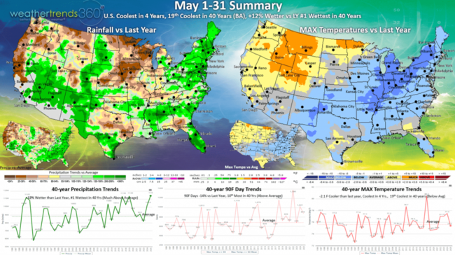
Hot 90F days were down -14% vs last year but still 10th most of the past 40 years. The Northeast had the biggest down trend. Rainfall was up +12% vs last year and the #1 wettest in over 40 years for the U.S. overall.

Year-to-date shows the Northeast having the fewest hot 90F days in 17 years, down -87% vs last year.
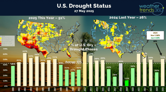
Drought was eliminated in the East, but expanding in the West, Rockies and Central Plains. Dry to drought phases across the U.S. was 51%, most in 3 years, vs only 26% last year (very wet).
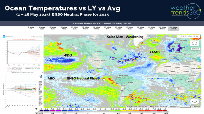
The Ocean temperatures continue to suggest a Neutral phase in the Equatorial Pacific Ocean, so no La Niña or El Niño for the balance of 2025.

The official start of the 2025 Hurricane season begins 1 June with all forecasts suggesting an above average season. WT360 expects the highest risk regions to be the Caribbean, East Coast of Florida and the Coastal Northeast. The Gulf has early season risk.
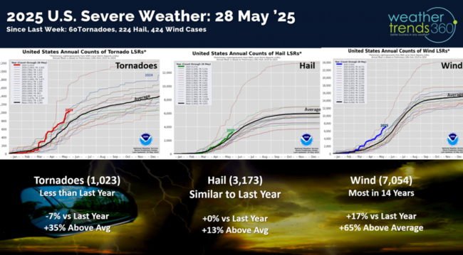
Severe weather was less extreme this past week adding 60 tornadoes, 224 hail events and 424 wind cases. Tornadoes are now down -7% vs last year, hail cases flat to last year, but wind cases still the most in 14 years.
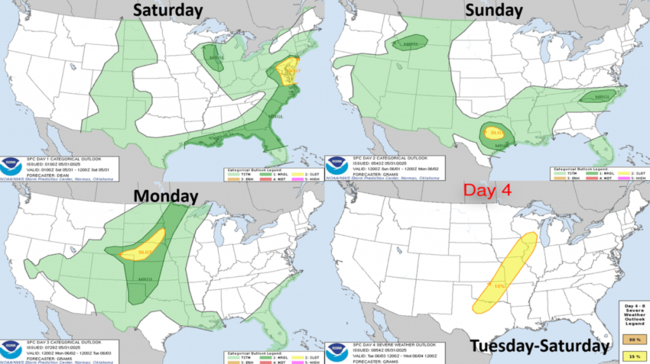
The 4-day severe weather outlook shows the threat shifting back to Texas and then the Central Plains.
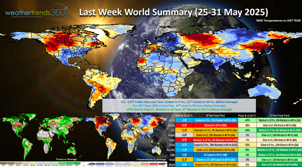 Last week (25-31 May) across the World shows another cool week in the U.S. trending -2.0F cooler than last year, coolest in 4 years and 11th coolest of the past 40 years with well below average national temperatures. Hot 90F days were also down -30% vs last year, while rainfall was up +37%, the most in 10 years and 8th most of the past 40 years. These are very negative trends for retail seasonal sales. Downright cold by India standards trending #1 coolest in 40 years, while Canada was the hottest in 39 years.
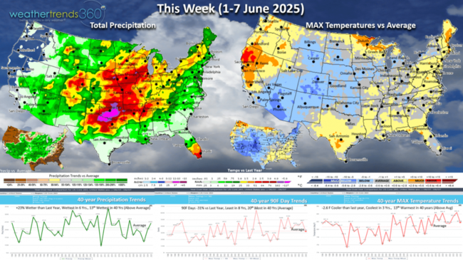
This week (1-7 June) shows some warmer weather and midweek heat moving into the Northeast, but the U.S. overall still trends -2.6F cooler than last year, coolest in 3 years and 13th warmest of the past 40 years. The Northwest is the warm spot but cooling from recent extremes. Hot 90F days nationally are down -31%, least in 8 years, while rainfall is again up +23% vs last year, wettest in 6 years. These are again unfavorable trends, but the warmer/drier week in the East will lead to a minor uptick in seasonal hot category sales.
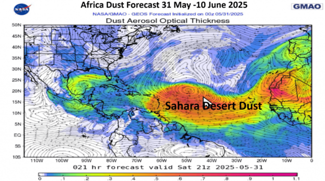
Africa dust of the Sahara Desert likely to invade the Southern U.S. this week which can lead to an uptick in Asthma and Allergy product sales. This also tends to inhibit tropical cyclone development.
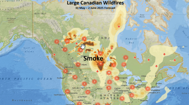
And up North, Canada is having another year of very large fires a bit East of where they were a couple years ago. Smoke from these fires will increase and spill into the U.S. over the weeks ahead.
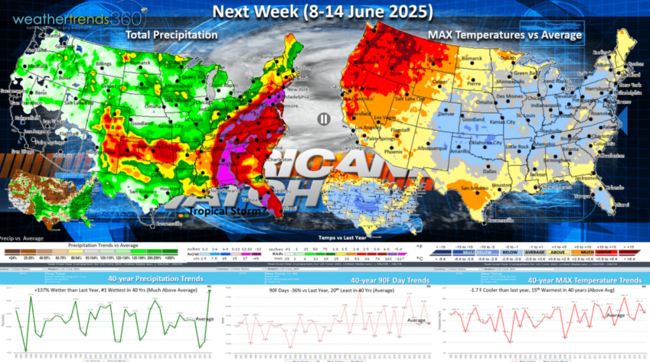
Next week (8-14 June) shows a return to cooler weather Central and East while the heat returns to the West and Pacific Northwest. The U.S. overall trends -1.7F cooler than last year but 15th warmest of the past 40 years. Hot 90F days remain down -36% vs last year and 20th least in 40 years, while rainfall is again off the scale trending +137% over last year and #1 most in 40 years. This is very much dependent on a tropical system impacting the Gulf of Mexico and East Coast - TBD on that as models do hallucinate this time of year. This is another soft week for retail and hot seasonal category sales.
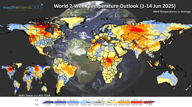
The World 2-week outlook (1-14 June) shows generally cooler and wetter conditions in the Eastern half of the U.S. and hotter West. Europe trending warmer than last year.
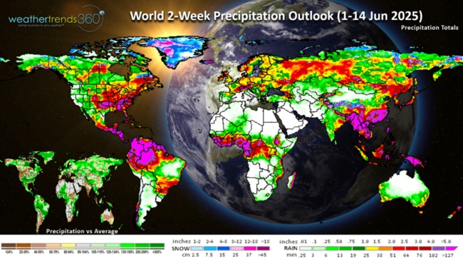
The World 2-week rainfall outlook (1-14 June) shows above average rainfall in the U.S., much of Brazil and Central Europe.
Have a great week and don't forget to follow us on social media for frequent updates: Facebook, Twitter, YouTube, Pinterest and Linkedin.
- Captain Kirk out
Hard to believe that May is in the history books and the theme was cool and very wet. May 2025 for the U.S. overall was the coolest in 4 years, 19th coolest of the past 40 years with below average national temperatures. CLICK ON IMAGES FOR A LARGER VIEW.
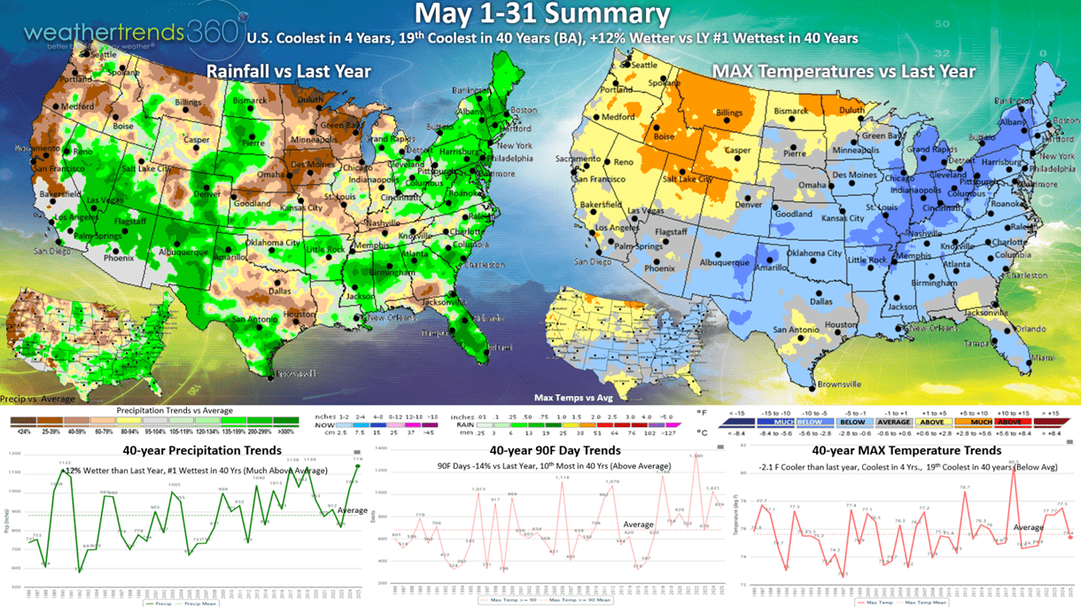
Hot 90F days were down -14% vs last year but still 10th most of the past 40 years. The Northeast had the biggest down trend. Rainfall was up +12% vs last year and the #1 wettest in over 40 years for the U.S. overall.
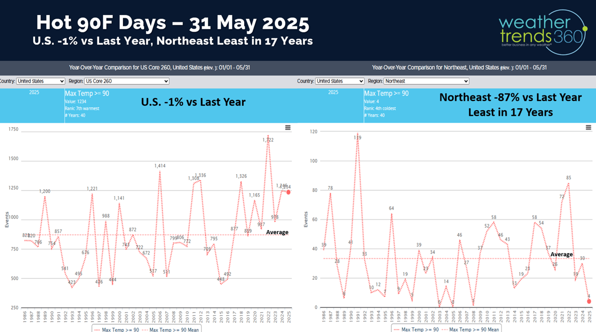
Year-to-date shows the Northeast having the fewest hot 90F days in 17 years, down -87% vs last year.
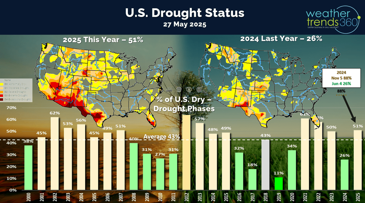
Drought was eliminated in the East, but expanding in the West, Rockies and Central Plains. Dry to drought phases across the U.S. was 51%, most in 3 years, vs only 26% last year (very wet).

The Ocean temperatures continue to suggest a Neutral phase in the Equatorial Pacific Ocean, so no La Niña or El Niño for the balance of 2025.
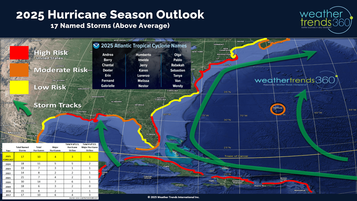
The official start of the 2025 Hurricane season begins 1 June with all forecasts suggesting an above average season. WT360 expects the highest risk regions to be the Caribbean, East Coast of Florida and the Coastal Northeast. The Gulf has early season risk.

Severe weather was less extreme this past week adding 60 tornadoes, 224 hail events and 424 wind cases. Tornadoes are now down -7% vs last year, hail cases flat to last year, but wind cases still the most in 14 years.
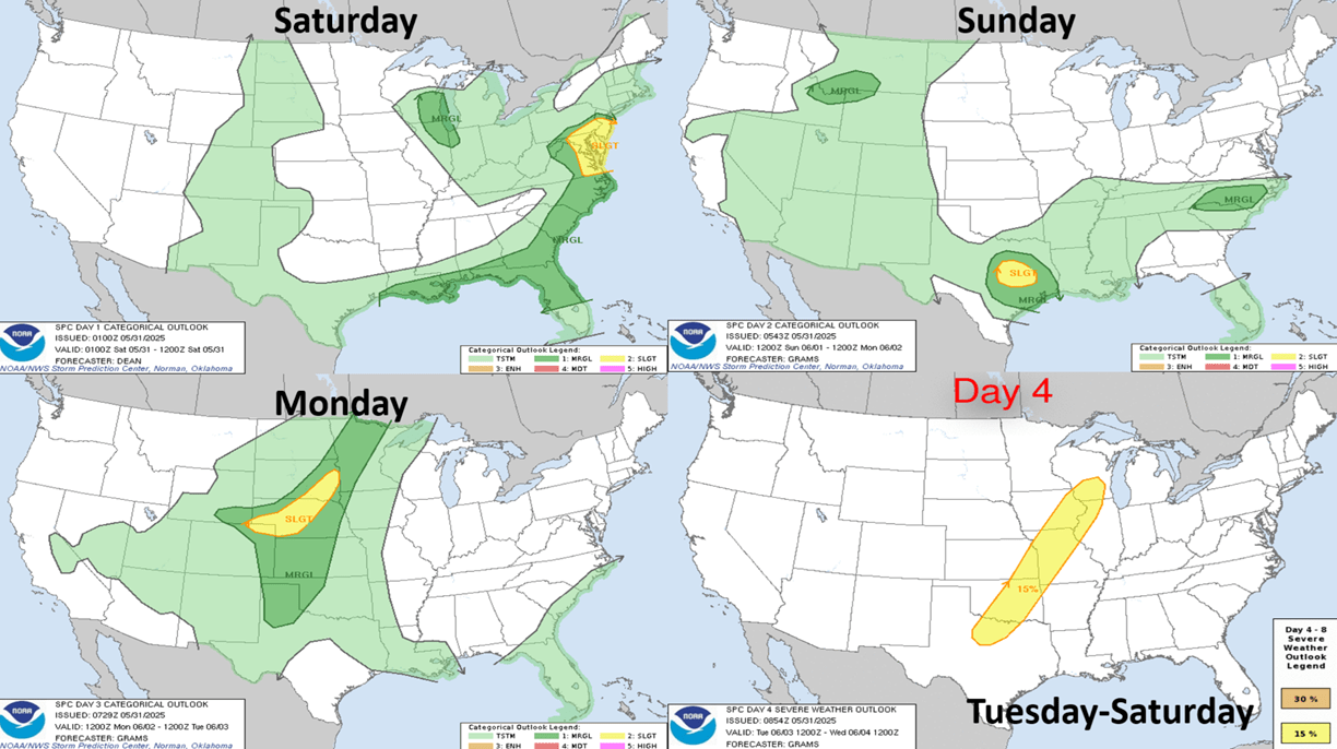
The 4-day severe weather outlook shows the threat shifting back to Texas and then the Central Plains.
Last week (25-31 May) across the World shows another cool week in the U.S. trending -2.0F cooler than last year, coolest in 4 years and 11th coolest of the past 40 years with well below average national temperatures. Hot 90F days were also down -30% vs last year, while rainfall was up +37%, the most in 10 years and 8th most of the past 40 years. These are very negative trends for retail seasonal sales. Downright cold by India standards trending #1 coolest in 40 years, while Canada was the hottest in 39 years.
This week (1-7 June) shows some warmer weather and midweek heat moving into the Northeast, but the U.S. overall still trends -2.6F cooler than last year, coolest in 3 years and 13th warmest of the past 40 years. The Northwest is the warm spot but cooling from recent extremes. Hot 90F days nationally are down -31%, least in 8 years, while rainfall is again up +23% vs last year, wettest in 6 years. These are again unfavorable trends, but the warmer/drier week in the East will lead to a minor uptick in seasonal hot category sales.
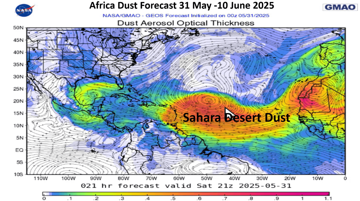
Africa dust of the Sahara Desert likely to invade the Southern U.S. this week which can lead to an uptick in Asthma and Allergy product sales. This also tends to inhibit tropical cyclone development.

And up North, Canada is having another year of very large fires a bit East of where they were a couple years ago. Smoke from these fires will increase and spill into the U.S. over the weeks ahead.

Next week (8-14 June) shows a return to cooler weather Central and East while the heat returns to the West and Pacific Northwest. The U.S. overall trends -1.7F cooler than last year but 15th warmest of the past 40 years. Hot 90F days remain down -36% vs last year and 20th least in 40 years, while rainfall is again off the scale trending +137% over last year and #1 most in 40 years. This is very much dependent on a tropical system impacting the Gulf of Mexico and East Coast - TBD on that as models do hallucinate this time of year. This is another soft week for retail and hot seasonal category sales.

The World 2-week outlook (1-14 June) shows generally cooler and wetter conditions in the Eastern half of the U.S. and hotter West. Europe trending warmer than last year.

The World 2-week rainfall outlook (1-14 June) shows above average rainfall in the U.S., much of Brazil and Central Europe.
Have a great week and don't forget to follow us on social media for frequent updates: Facebook, Twitter, YouTube, Pinterest and Linkedin.
- Captain Kirk out