Christmas 2018 Weather Forecast
You'll have to dream a little harder this year if you're hoping for a White Christmas. Despite some record snowfall last week in the Southeast, the odds of a White Christmas 2018 are looking pretty slim for over half of the nation. However, the forecast isn't all that straight-forward this year as we'll be undergoing a transition from a relatively milder period of weather to a colder one right around Christmas. The difference of a day or two could mean a white or green Christmas.
As of December 18th, 21.8% of the U.S. was covered in snow, that's down from last year at this same time when 29.9% of the U.S. was snow-covered. Snow pack from northern South Carolina to central Virginia quickly vanished over this past weekend thanks to warmer weather and heavy rainfall. In fact, this past weekend's rainfall pushed several locations to their wettest year ever, including an incredible +100'' of rain in Wilmington, NC. Read more here about how wildly wet 2018 has been.
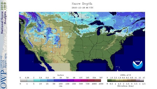
The snow pack is thinning out across the northern Plains and Upper Midwest in the days ahead as temperatures trend much warmer than normal (+15F above normal in some places) in the next 7 days. The next opportunity for the snow pack to rebuild will be in the last few days before Christmas, so we'll be cutting it really close. Meanwhile, the snow pack will be building in the mountains of the West and the Northern Rockies, ensuring a White Christmas for Sasquatch.
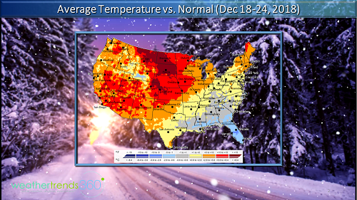
In the East we'll see a moderation in temperatures with a fairly heavy rain storm in the upcoming weekend. Any chance of a White Christmas will depend on the chance of snow between Saturday and Tuesday. Lake-Effect snow should help to increase odds in the typical areas downwind of the Great Lakes, but all is not completely lost for the rest of the Northeast as a Clipper system could bring some light snow on Christmas Eve. However, these types of systems tend to be moisture-starved and difficult to predict this far out.

This year's White Christmas Likelihood Matrix is dominated by a lot of red "Very Unlikely", which is bad news if you were wishing for a White Christmas; 46% of the U.S. will likely see a "Green" Christmas. The purple "High" likelihood of snow on the ground on Christmas Day is reserved to the far northern cities and accounts for only about 6% of the U.S. The blue "Medium" category mainly captures those locations where snow on the ground by Christmas will depend largely on the arrival of cold air and precipitation; this accounts for about 30% of the U.S.
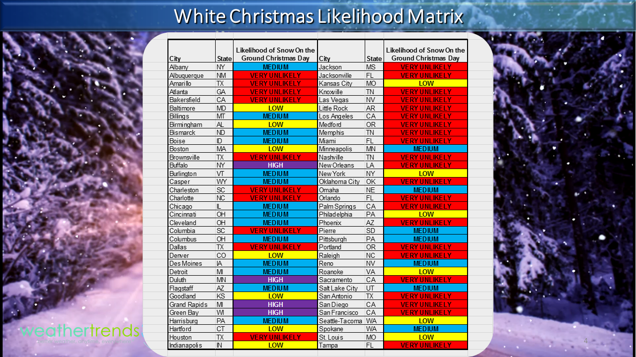
The best bet, as usual, for a White Christmas will be to head north - far north with places like Buffalo, NY; Duluth, MN; Grand Rapids, MI; and Green Bay, WI seeing the best chances for a White Christmas, as far as larger cities go. Of course, the higher elevations are always a good bet this time of year for snow as well. For the rest of us, snow will be hard to come by, especially south of the Mason-Dixon line. And if you live in the South, keep on dreaming, or better yet, move north or up into the mountains!
Don't let the White Christmas get you down if you're a snow lover. Remember the Polar Vortex? Well, it's going to become part of the common nomenclature on the nightly news over the next few weeks. We're watching for the potential for the Polar Vortex to bring us a rather cold and snowy winter (January-early March). So hang in there!