Captain's Blog 12 Jul '25 Relatively Cooler Wetter Week Ahead
Captain's Log
12 July 2025: Happy Saturday :)
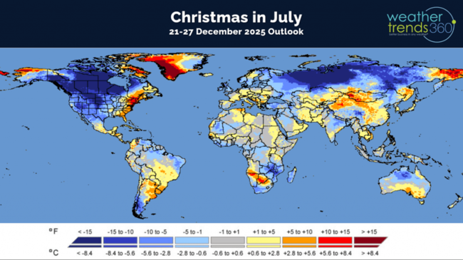
If you're looking for really cold trends, look to December 2025 and Christmas week which shows the potential for a very cold start to Winter! That's all we have to say about that for now. :) CLICK ON IMAGES FOR A LARGER VIEW
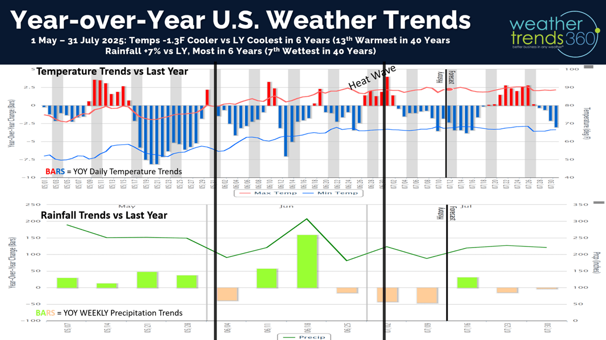
The year-over-year weather trends from May - July show a generally cooler/wetter pattern than this time last year. Despite the late June heatwave, the 3-month period is on pace to be -1.3F cooler than last year nationally, coolest in 6 years and 13th warmest of the past 40 years. Rainfall up +7%, also the most in 6 years and 7th wettest of the past 40 years. These are soft trends for hot Summer categories compared to the exceptional conditions last year.

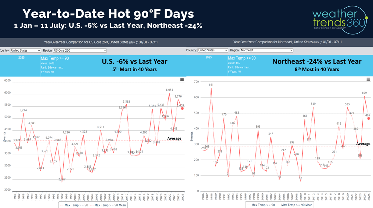
U.S. Hot 90F days to date are down -6% vs last year nationally, but still 5th most in 40 years. The Northeast is down -24% vs last year but 8th most of the past 40 years.

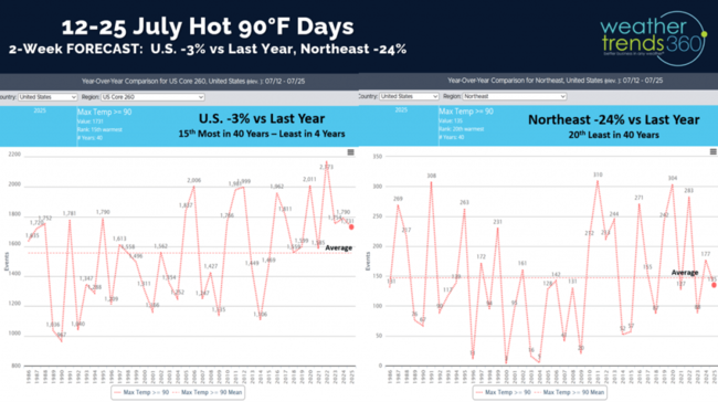
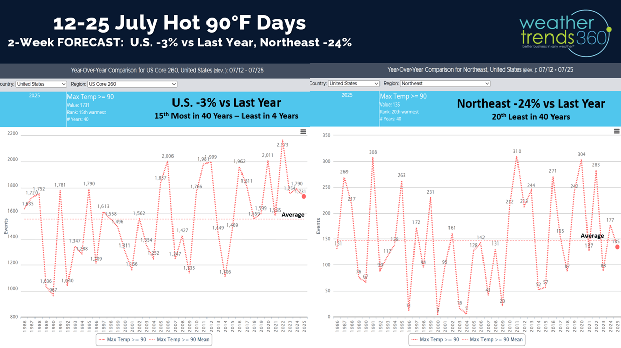
The 2-week outlook (12-25 July) shows hot 90F days trending down -3% vs last year for the U.S. overall, but 15th most of the past 40 years. The Northeast trends down -24% vs LY and 20th least in 40 years.
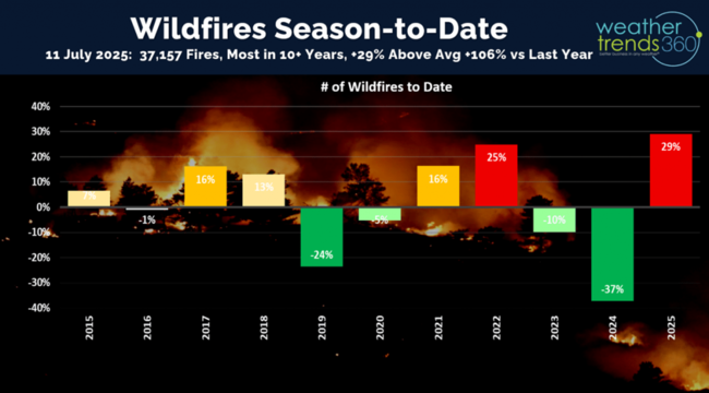
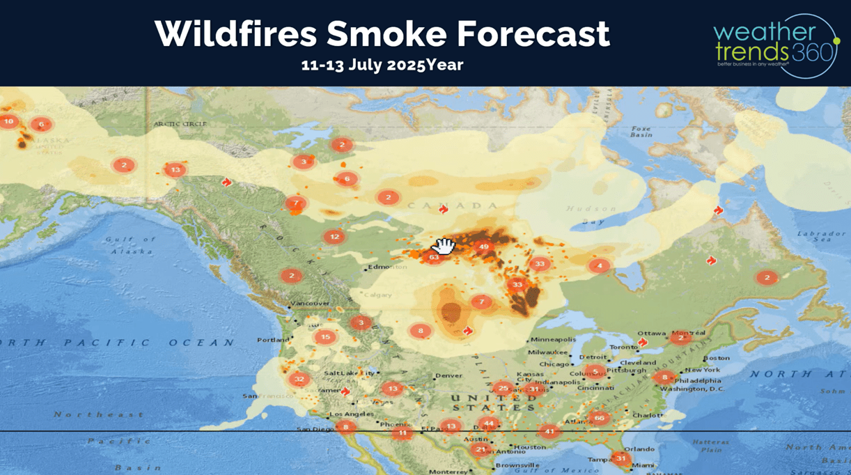
Wildfires aren't making headline news just yet, but the number of active fires is the most in over 10 years, +29% above average and a significant +106% vs last year. This will become a bigger problem in the late Summer-Fall core season.
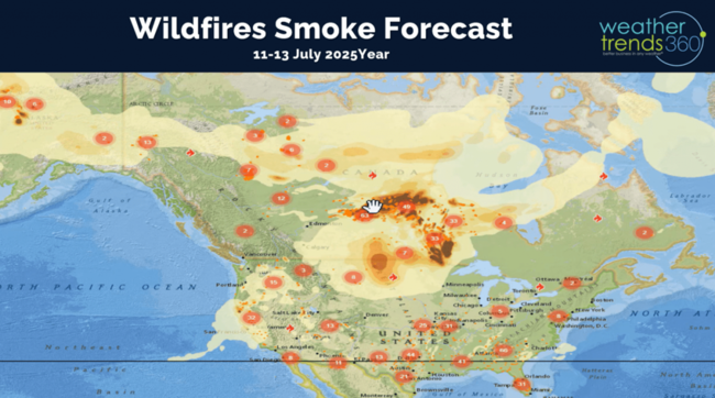
The 3-day smoke forecast (12-14 July) shows the fires in Canada beginning to expand bringing more smoke into the U.S.
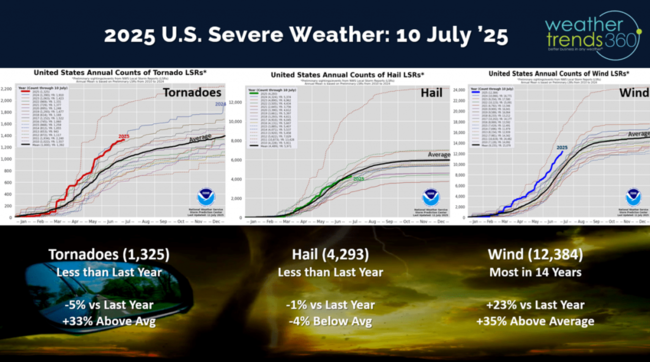
Severe Weather wasn't quite as active last week with tornadoes year-to-date now trending down -5% vs last year but still +33% above average. Hail is down -1% vs last year, while Wind cases remain the most in 14 years and +23% more than last year.
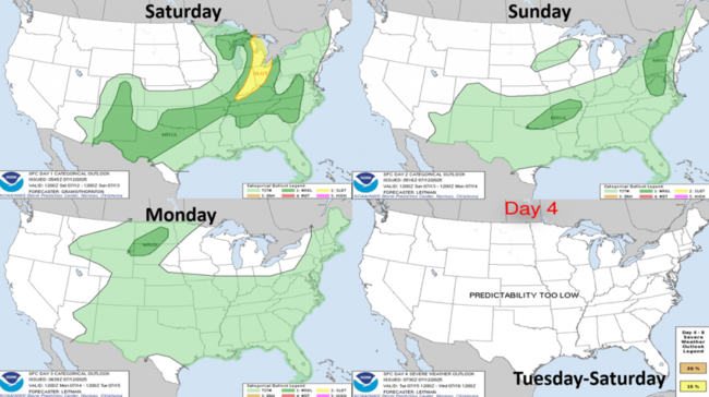
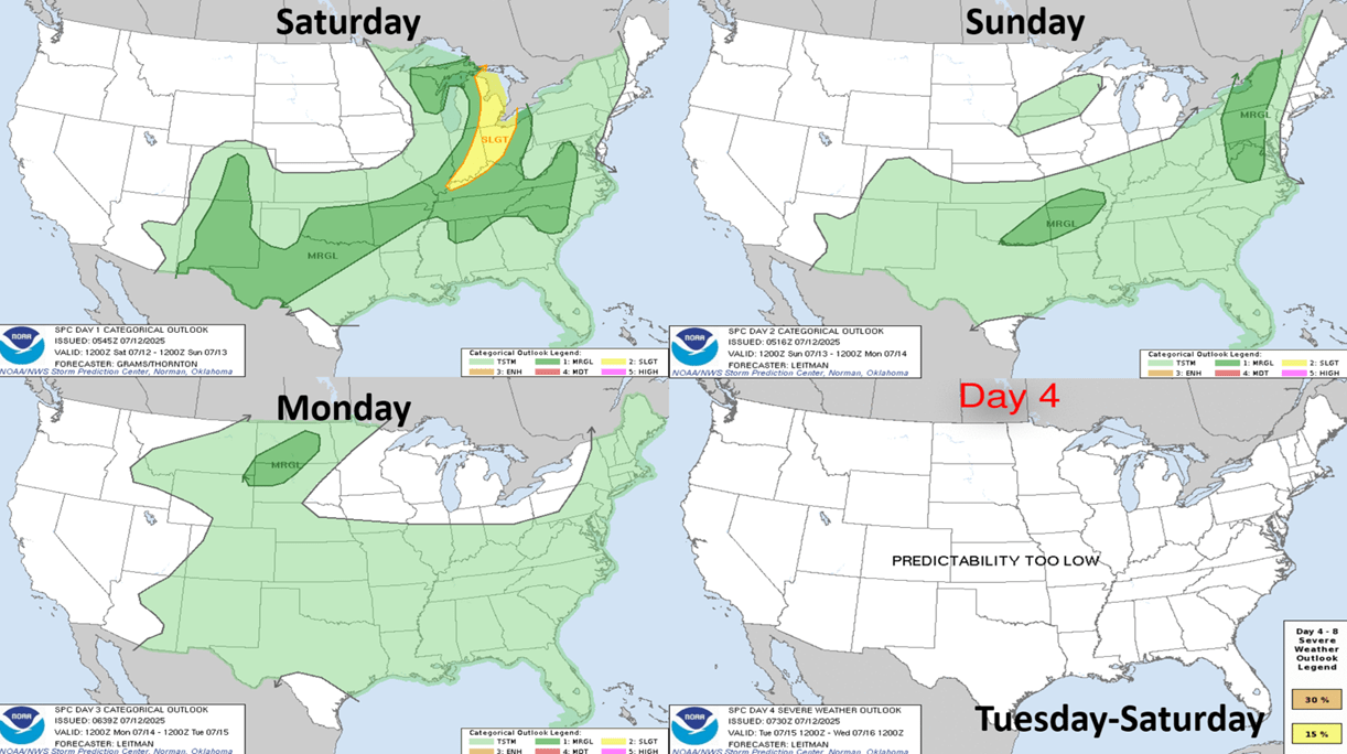
The Severe Weather outlook shows a stronger system in the Great Lakes today with an elevated risk.
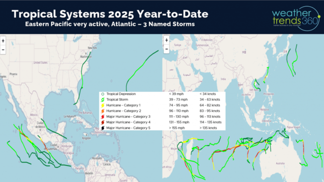
wt360 has a mapped every tropical system going back 183 years with data showing which zip codes, stores, warehouses and other custom locations were impacted by varying level of winds. The 2025 season-to-date shows an active Eastern Pacific with the one bigger CAT 2 hurricane Erick making landfall south of Acapulco Mexico. The Atlantic has 3 short lived Tropical Storms while the Indian Ocean has been active.
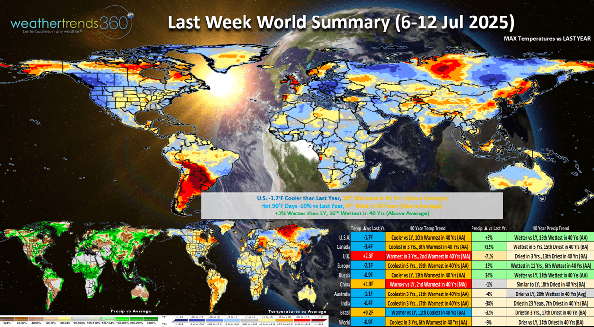
Last week (6-12 July) across the World shows the U.S. trending -1.7F cooler than last year, but 10th warmest of the past 40 years. Hot 90F days were down -10% vs last year but still 6th most of the past 40 years, while rainfall was up +3% vs LY and 16th wettest of the past 40 years. These are somewhat soft trends for hot Summer seasonal categories for the East Coast and West Coast. U.K. had the most extreme weather with the 2nd hottest conditions in 40 years benefiting Summer seasonal items.

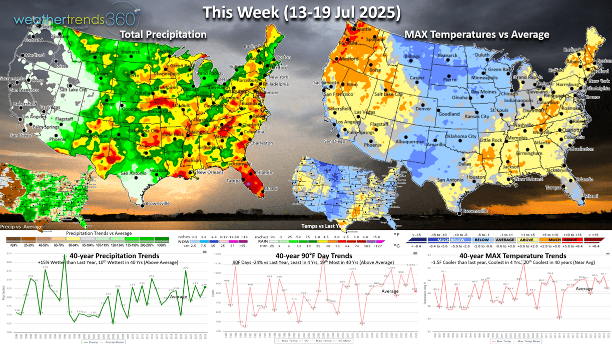
This week (13-19 July) shows a very strong cold front moving by July standards moving into the Central U.S. The East Coast will warm up ahead of the front while the Pacific Northwest has very hot conditions. U.S. temperatures trend down -1.5F cooler vs LY, coolest in 4 years and 20th coolest of the past 40 years. Hot 90F days down -24% vs LY, least in 4 years but 19th most in 40 years, while rainfall is up +15% vs LY and 10th most in 40 years. Overall these are somewhat soft trends for Summer seasonal sales, especially the Central U.S.

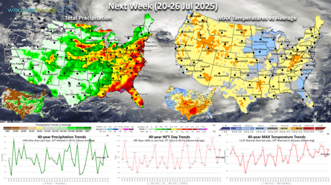
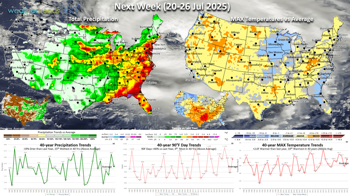
Next week (20-26 July) shows national temperatures trending +2.0F warmer than last year and 10th warmest of the past 40 years vs a cool week a year ago. Hot 90F days up +40% vs last year and 9th most in 40 years, while rainfall is down -19% vs LY but 15th wettest of the past 40 years. Need to start watching the tropics as we near the core peak season of August - October. Some models have been hinting at another system developing along a stalled front in the NE Gulf or off the Southeast coast. Overall this is a slightly positive week for Summer seasonal sales.
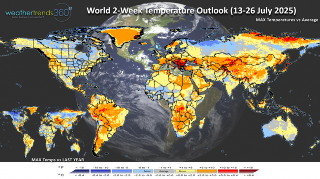
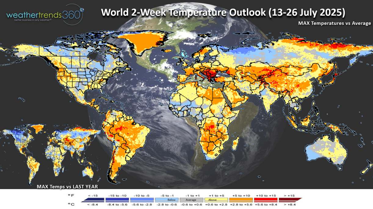
The World 2-week Temperature Outlook (13-26 July) shows hotter conditions for the NW U.S., cooler in the middle and seasonably warm on the East Coast. Not as extreme in the U.K. with a warming trend for Eastern Europe.
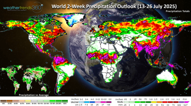
The World 2-week Precipitation Outlook (13-26 July) shows a stormy pattern across the U.S., but drier in Europe. This time of year warmer/drier trends are more favorable for Summer seasonal categories and consumable food and beverage items.
Have a great week ahead and don't forget to follow us on social media for frequent updates: Facebook, Twitter(X), YouTube, Pinterest and Linkedin.
- Captain Kirk out
If you're looking for really cold trends, look to December 2025 and Christmas week which shows the potential for a very cold start to Winter! That's all we have to say about that for now. :) CLICK ON IMAGES FOR A LARGER VIEW

The year-over-year weather trends from May - July show a generally cooler/wetter pattern than this time last year. Despite the late June heatwave, the 3-month period is on pace to be -1.3F cooler than last year nationally, coolest in 6 years and 13th warmest of the past 40 years. Rainfall up +7%, also the most in 6 years and 7th wettest of the past 40 years. These are soft trends for hot Summer categories compared to the exceptional conditions last year.
U.S. Hot 90F days to date are down -6% vs last year nationally, but still 5th most in 40 years. The Northeast is down -24% vs last year but 8th most of the past 40 years.
The 2-week outlook (12-25 July) shows hot 90F days trending down -3% vs last year for the U.S. overall, but 15th most of the past 40 years. The Northeast trends down -24% vs LY and 20th least in 40 years.
Wildfires aren't making headline news just yet, but the number of active fires is the most in over 10 years, +29% above average and a significant +106% vs last year. This will become a bigger problem in the late Summer-Fall core season.

The 3-day smoke forecast (12-14 July) shows the fires in Canada beginning to expand bringing more smoke into the U.S.
Severe Weather wasn't quite as active last week with tornadoes year-to-date now trending down -5% vs last year but still +33% above average. Hail is down -1% vs last year, while Wind cases remain the most in 14 years and +23% more than last year.

The Severe Weather outlook shows a stronger system in the Great Lakes today with an elevated risk.
wt360 has a mapped every tropical system going back 183 years with data showing which zip codes, stores, warehouses and other custom locations were impacted by varying level of winds. The 2025 season-to-date shows an active Eastern Pacific with the one bigger CAT 2 hurricane Erick making landfall south of Acapulco Mexico. The Atlantic has 3 short lived Tropical Storms while the Indian Ocean has been active.

Last week (6-12 July) across the World shows the U.S. trending -1.7F cooler than last year, but 10th warmest of the past 40 years. Hot 90F days were down -10% vs last year but still 6th most of the past 40 years, while rainfall was up +3% vs LY and 16th wettest of the past 40 years. These are somewhat soft trends for hot Summer seasonal categories for the East Coast and West Coast. U.K. had the most extreme weather with the 2nd hottest conditions in 40 years benefiting Summer seasonal items.
This week (13-19 July) shows a very strong cold front moving by July standards moving into the Central U.S. The East Coast will warm up ahead of the front while the Pacific Northwest has very hot conditions. U.S. temperatures trend down -1.5F cooler vs LY, coolest in 4 years and 20th coolest of the past 40 years. Hot 90F days down -24% vs LY, least in 4 years but 19th most in 40 years, while rainfall is up +15% vs LY and 10th most in 40 years. Overall these are somewhat soft trends for Summer seasonal sales, especially the Central U.S.
Next week (20-26 July) shows national temperatures trending +2.0F warmer than last year and 10th warmest of the past 40 years vs a cool week a year ago. Hot 90F days up +40% vs last year and 9th most in 40 years, while rainfall is down -19% vs LY but 15th wettest of the past 40 years. Need to start watching the tropics as we near the core peak season of August - October. Some models have been hinting at another system developing along a stalled front in the NE Gulf or off the Southeast coast. Overall this is a slightly positive week for Summer seasonal sales.
The World 2-week Temperature Outlook (13-26 July) shows hotter conditions for the NW U.S., cooler in the middle and seasonably warm on the East Coast. Not as extreme in the U.K. with a warming trend for Eastern Europe.
The World 2-week Precipitation Outlook (13-26 July) shows a stormy pattern across the U.S., but drier in Europe. This time of year warmer/drier trends are more favorable for Summer seasonal categories and consumable food and beverage items.

Have a great week ahead and don't forget to follow us on social media for frequent updates: Facebook, Twitter(X), YouTube, Pinterest and Linkedin.
- Captain Kirk out