Captain's Blog 13 Sep '25 Cooler vs LY but Still Warm & Dry
Captain's Log
13 September 2025
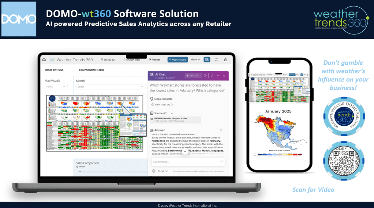
We're headed to DOMO's AI + Data connections tour event in New York City on 21 October from 12-6pm, please join us for this free event. REGISTER

We'll explain how our DOMO-wt360 year-ahead seasonal category sales forecasting tool works and saves hundreds of labor hours with fast actionable business decisions. See ya there. CLICK ON IMAGES FOR A LARGER VIEW

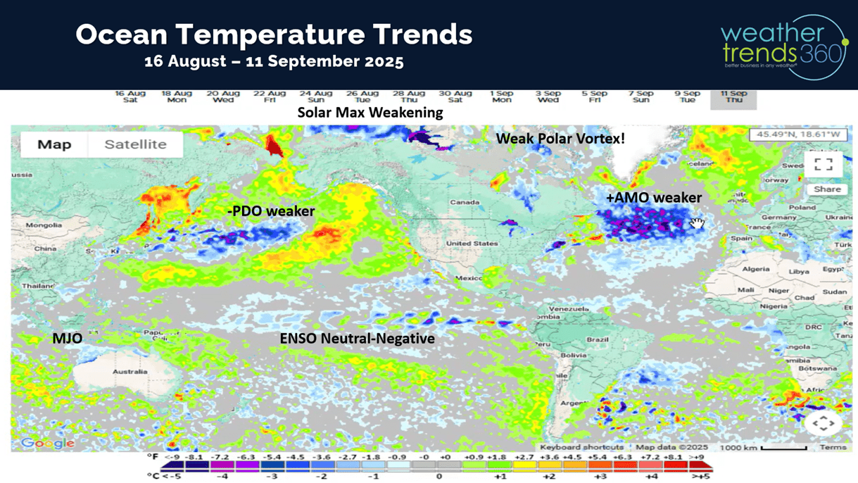
The ocean cycles suggest some changes are in store for later this Fall and Winter with a cool and potentially snowy theme.

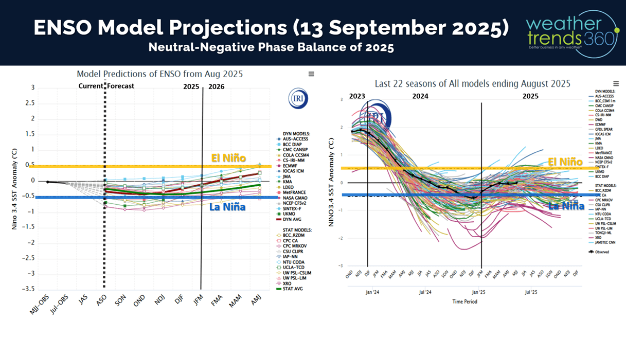
The equatorial Pacific Ocean looks to remain in a weak neutral phase, but combined with other climate cycles suggests a weak polar vortex this Winter. This allows the cold air to invade more easily so another cold Winter ahead.

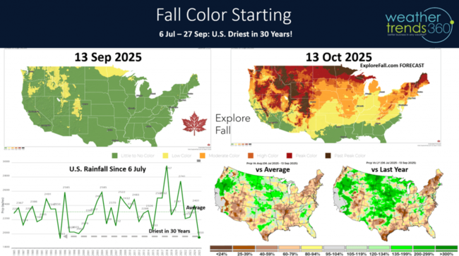
The past 2.5 months have been exceptionally dry for the U.S. overall with the nation trending the driest in 30 years, especially in the Northeast, South Central and Southwest. This has trees stressed so they're likely to change quickly and earlier with potentially vibrant colors. Visit Fall Explorer for current and forecast conditions.
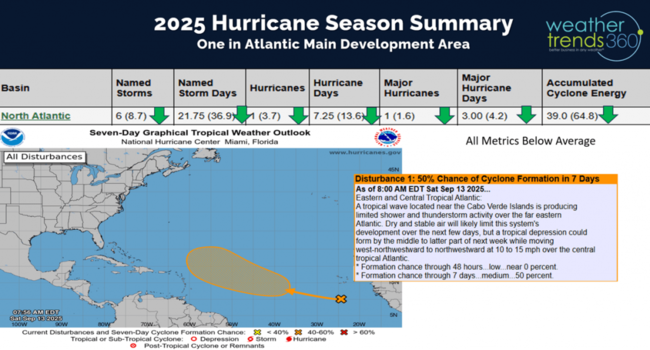
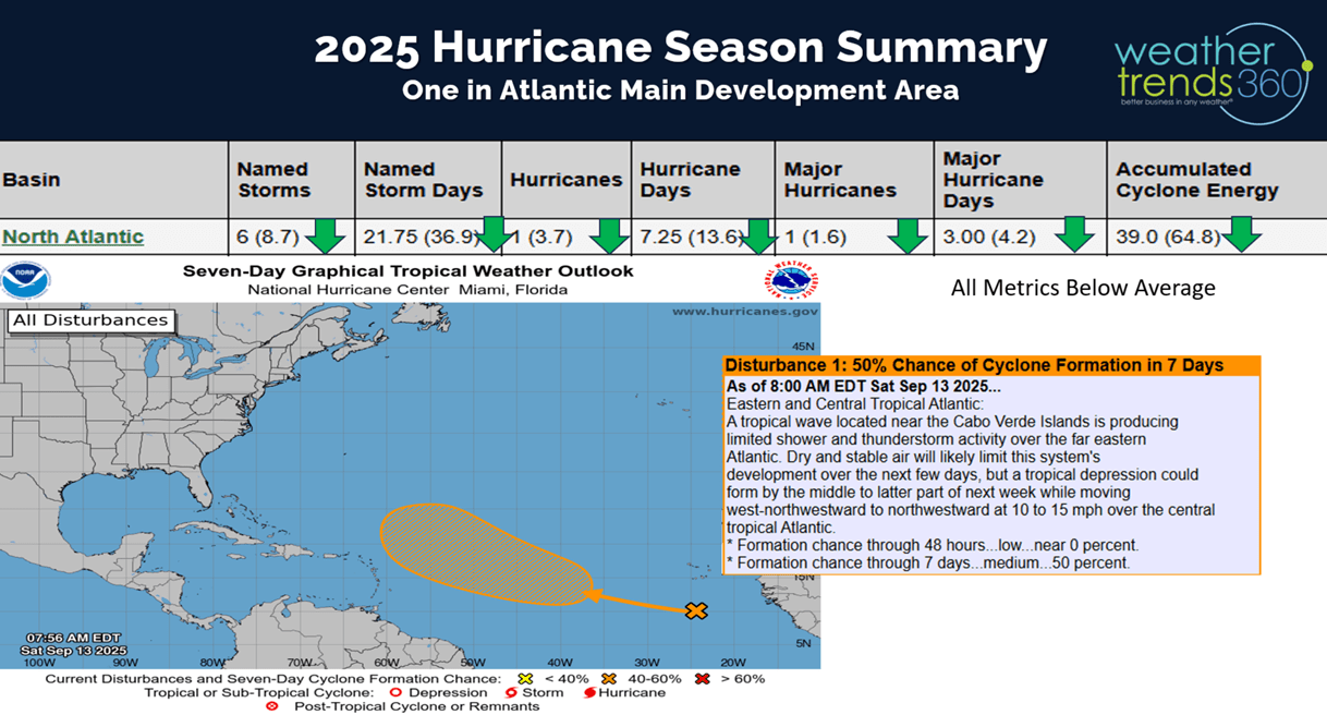
We're at the peak of the hurricane season, but only 1 system way out in the Atlantic with any near-term potential for development.

A favorable MJO cycle and very warm water temperatures in the Gulf and Atlantic suggest systems could flare up quickly. We have 78 days left in the season, so by no means over.
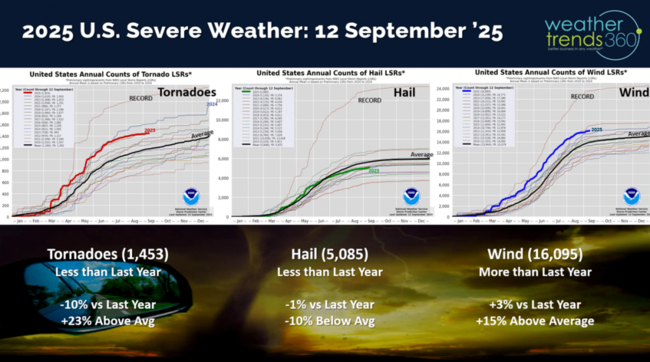
Severe weather has been decreasing with the drier pattern and year-to-date tornadoes down -10% vs last year, hail down -1% but wind cases up +3%.
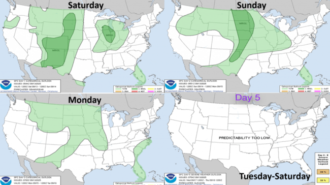
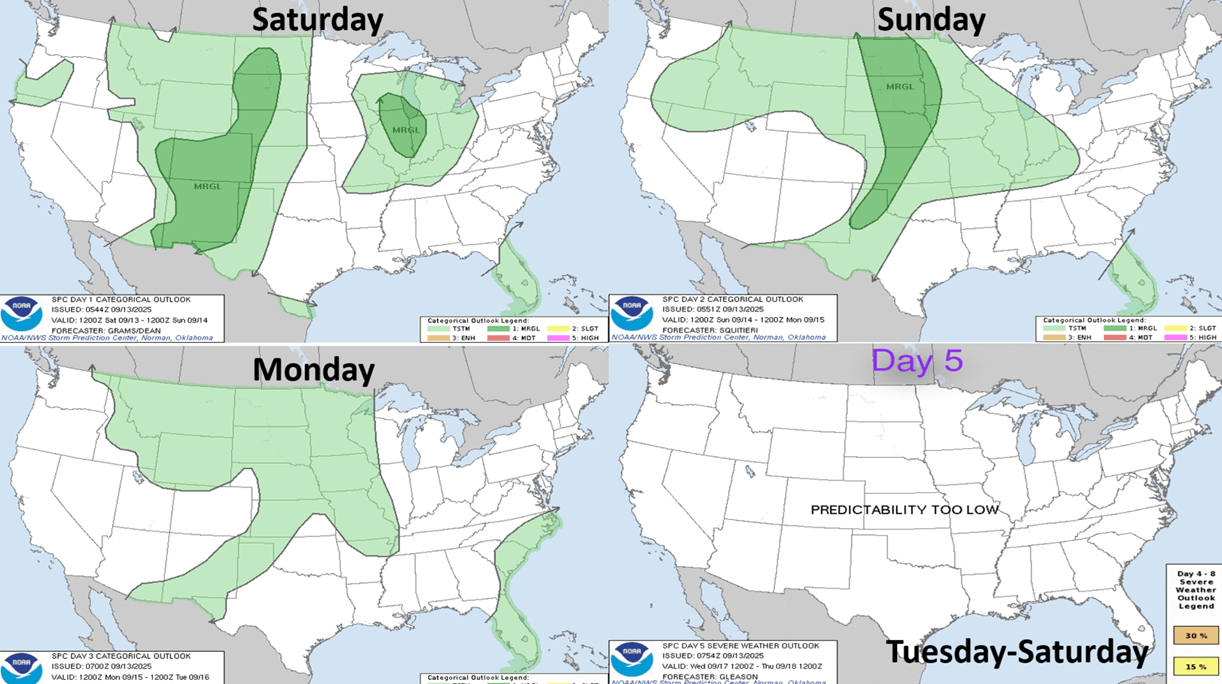
The 3-day outlook shows some risk in the Southern Rockies and Central Plains.
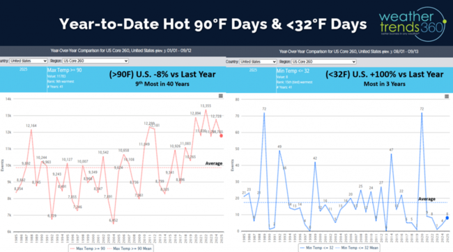
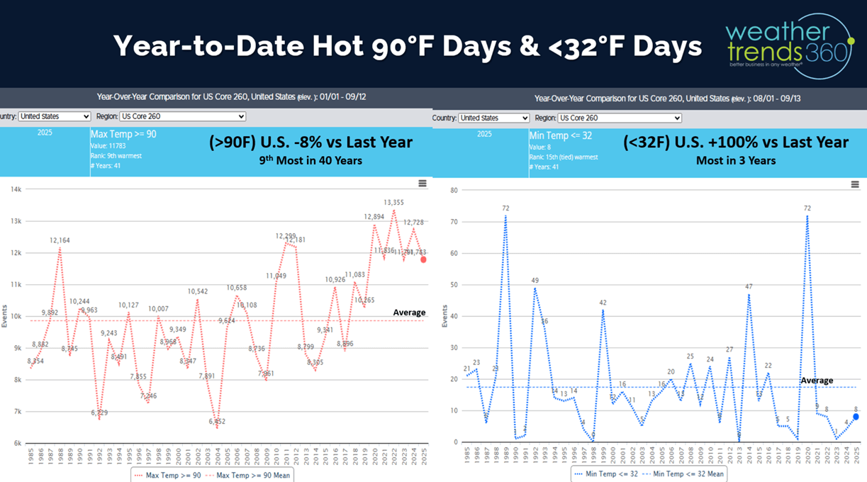
Just about done talking about hot 90F days as we begin to track cold and snowy days in the weeks ahead. YTD hot 90F days nationally are down -8% vs last year but still 9th most of the past 40 years. Cold 32F days are just getting started and trending twice as much as last year and most in 3 years.
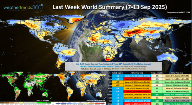
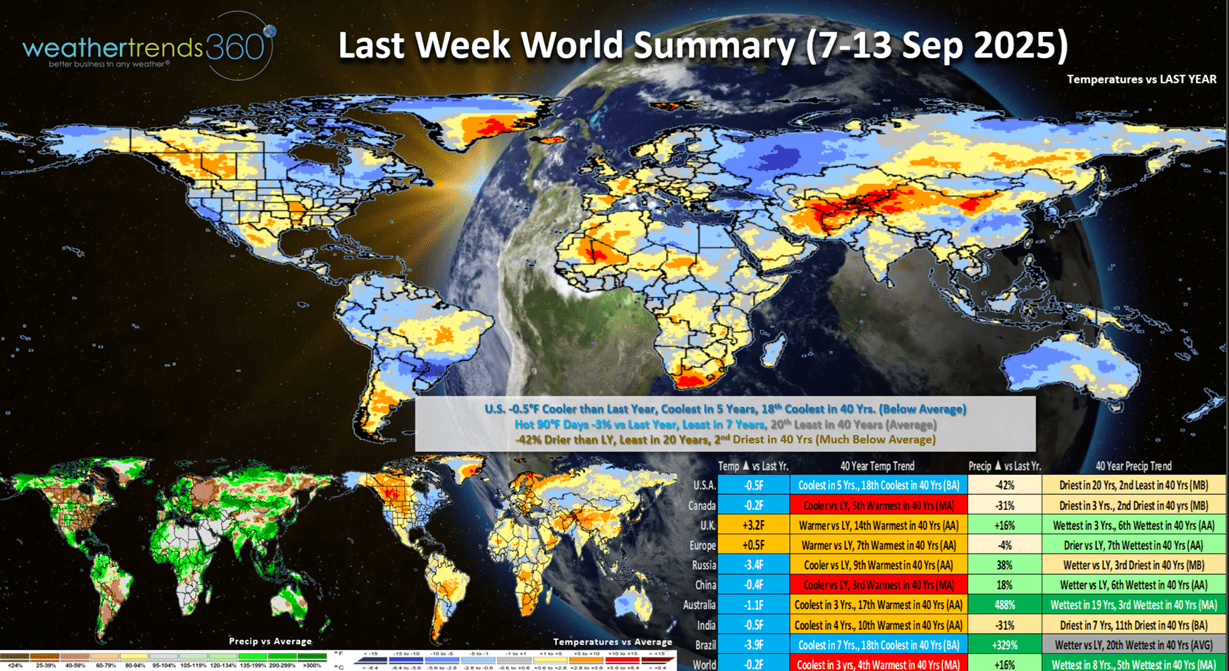
Last week (7-13 Sep) across the World shows the U.S. trending -0.5F cooler than last year, coolest in 5 years and 18th coolest of the past 40 years with below average national temperatures. Hot 90F days down -3%, least in 7 years, while rainfall was down -42% and least in 20 years. This time of year, colder/wetter weather is better for Fall seasonal merchandise sales, so we have part of the equation with cooler conditions especially East and California. Europe was warmer.
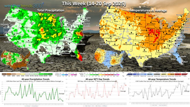
This week (14-20 Sep) shows a warming trend, but still -0.4F cooler than last year, 4th warmest of the past 40 years. Hot 90F days are down -8% vs last year, 7th most in 40 years, while rainfall is down -12% and the driest in 18 years. These are not particularly favorable trends for Fall merchandise sales.
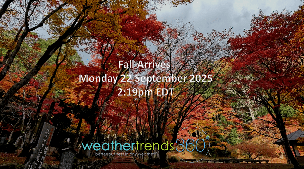
Fall arrives Monday 22 September 2025 at 2:19pm EDT

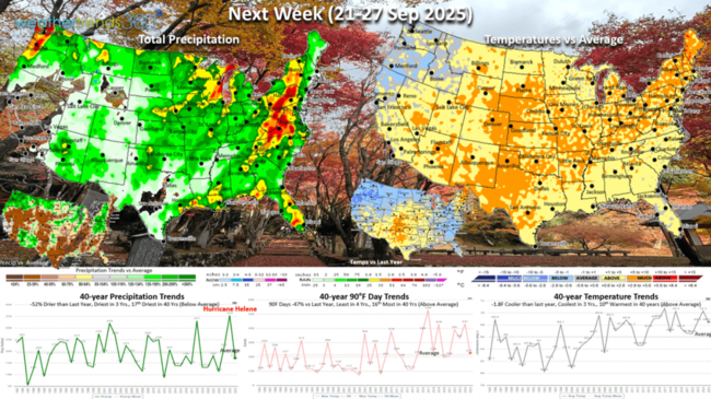
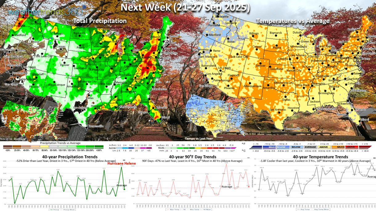
Next week (21-27 Sep) shows most of the country with above average temperatures, but still -1.8F cooler than last year and coolest in 3 years. Hot 90F days way down -47% vs last year and least in 4 years, while rainfall is down -52% and driest in 3 years. Again, it is slightly better than last year. A year-ago Hurricane Helene made landfall on the 27th with record rainfall for the U.S. overall. The lack of landfalling hurricanes in Q3 so far is a negative for Home Center sales that benefited with at least a +2% bounce in same-store-sales due to the hurricanes.
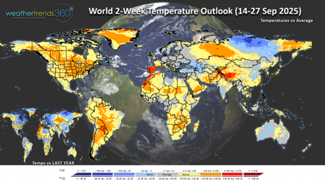
The World 2-week Temperature outlook (14-27 Sep) shows generally warm conditions for the U.S., Canada and Western Europe.
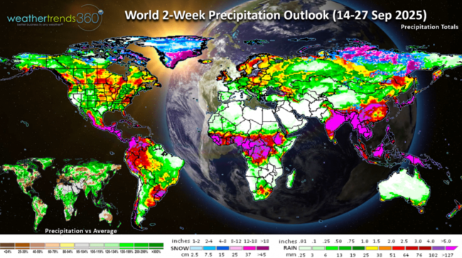
The World 2-week Precipitation outlook (14-27 Sep) shows a bit more rainfall for the U.S. Northwest, Central U.S. and Middle Atlantic. Very dry in Europe.
Have a great week ahead, and don't forget to follow us on social media for frequent updates: Facebook, Twitter(X), YouTube, Pinterest and Linkedin.
- Captain Kirk out
We're headed to DOMO's AI + Data connections tour event in New York City on 21 October from 12-6pm, please join us for this free event. REGISTER

We'll explain how our DOMO-wt360 year-ahead seasonal category sales forecasting tool works and saves hundreds of labor hours with fast actionable business decisions. See ya there. CLICK ON IMAGES FOR A LARGER VIEW
The ocean cycles suggest some changes are in store for later this Fall and Winter with a cool and potentially snowy theme.
The equatorial Pacific Ocean looks to remain in a weak neutral phase, but combined with other climate cycles suggests a weak polar vortex this Winter. This allows the cold air to invade more easily so another cold Winter ahead.
The past 2.5 months have been exceptionally dry for the U.S. overall with the nation trending the driest in 30 years, especially in the Northeast, South Central and Southwest. This has trees stressed so they're likely to change quickly and earlier with potentially vibrant colors. Visit Fall Explorer for current and forecast conditions.

We're at the peak of the hurricane season, but only 1 system way out in the Atlantic with any near-term potential for development.
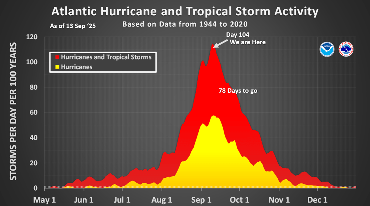
A favorable MJO cycle and very warm water temperatures in the Gulf and Atlantic suggest systems could flare up quickly. We have 78 days left in the season, so by no means over.
Severe weather has been decreasing with the drier pattern and year-to-date tornadoes down -10% vs last year, hail down -1% but wind cases up +3%.

The 3-day outlook shows some risk in the Southern Rockies and Central Plains.
Just about done talking about hot 90F days as we begin to track cold and snowy days in the weeks ahead. YTD hot 90F days nationally are down -8% vs last year but still 9th most of the past 40 years. Cold 32F days are just getting started and trending twice as much as last year and most in 3 years.
Last week (7-13 Sep) across the World shows the U.S. trending -0.5F cooler than last year, coolest in 5 years and 18th coolest of the past 40 years with below average national temperatures. Hot 90F days down -3%, least in 7 years, while rainfall was down -42% and least in 20 years. This time of year, colder/wetter weather is better for Fall seasonal merchandise sales, so we have part of the equation with cooler conditions especially East and California. Europe was warmer.
This week (14-20 Sep) shows a warming trend, but still -0.4F cooler than last year, 4th warmest of the past 40 years. Hot 90F days are down -8% vs last year, 7th most in 40 years, while rainfall is down -12% and the driest in 18 years. These are not particularly favorable trends for Fall merchandise sales.

Fall arrives Monday 22 September 2025 at 2:19pm EDT
Next week (21-27 Sep) shows most of the country with above average temperatures, but still -1.8F cooler than last year and coolest in 3 years. Hot 90F days way down -47% vs last year and least in 4 years, while rainfall is down -52% and driest in 3 years. Again, it is slightly better than last year. A year-ago Hurricane Helene made landfall on the 27th with record rainfall for the U.S. overall. The lack of landfalling hurricanes in Q3 so far is a negative for Home Center sales that benefited with at least a +2% bounce in same-store-sales due to the hurricanes.
The World 2-week Temperature outlook (14-27 Sep) shows generally warm conditions for the U.S., Canada and Western Europe.

The World 2-week Precipitation outlook (14-27 Sep) shows a bit more rainfall for the U.S. Northwest, Central U.S. and Middle Atlantic. Very dry in Europe.

Have a great week ahead, and don't forget to follow us on social media for frequent updates: Facebook, Twitter(X), YouTube, Pinterest and Linkedin.
- Captain Kirk out