Captain's Blog 21 Sep '24 Another U.S. Hurricane Threat!
Captain's Log
21 Sep '24: Happy Saturday! :)
It's the last few hours of Summer 2024 as Fall officially arrives Sunday 22 Sep at 8:44am EDT. CLICK ON IMAGES FOR A LARGER VIEW
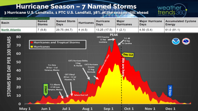
Day 112 of the 2024 hurricane season with 70 days to go. While the statistical metrics say the season is below average to date, the number of hurricane landfalls in the U.S. (3) is above the average of 2. This doesn't include potential tropical cyclone #8 that inundated North Carolina with major flooding.
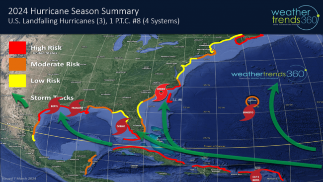
Last year there was only 1 U.S. landfall despite 20 named storms, and we're very likely going to add a couple more landfalling hurricanes before the season is done.
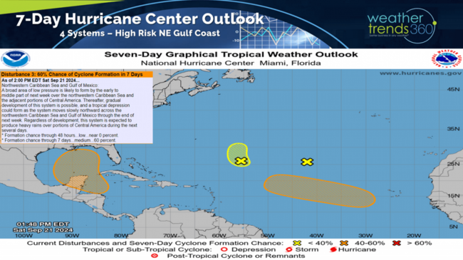
The National Hurricane Center is monitoring 4 threat areas, but the Caribbean - Gulf threat is near certain to bring the next U.S. landfalling hurricane.
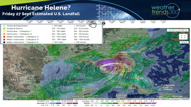
Almost all short-range models show a hurricane developing in the Gulf of Mexico where water temperatures are still near 87F, plenty of fuel for a rapidly developing system. Right now, the primary threat areas are from Alabama to Tampa Florida around Friday 27 Sept for a potential landfall. Tampa, FL has dodged MANY hurricanes over the past 176 years with only 2 major hurricane hits. The last major hurricane to hit Tampa was 103 years ago on 25 October 1921 and the one before that was the "Great Gale" CAT 4 Hurricane of 1848. TAMPA IS OVERDUE! The right front quadrant of any hurricane is significantly more dangerous and Tampa could be in that sector late this week. TBD
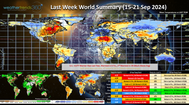
Last week (15-21 Sep) across the World shows the U.S. trending +4F warmer than last year, warmest in 6 years and 2nd warmest of the past 39 years. Rainfall was down -16%, least in 4 years and 4th driest in 39 years despite the major flooding in North Carolina from Potential Tropical Cyclone #8. Many argue this system should have been classified a landfalling Tropical Storm, it still might be after the National Hurricane Center reevaluates the data later this Fall. This time of year, colder/wetter conditions are more favorable for Fall merchandise sales. The West Coast was the most favorable area for Fall sales with the Eastern U.S. very unfavorable.
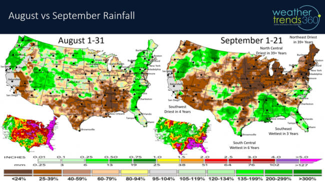
September rainfall has plummeted here in the Northeast after a wet August but now the driest first 21 days of September in over 40 years and in some cases the driest in 129 years. The North Central is equally dry while the South Central is the wettest in 6 years, the Southeast the wettest in 3 years. We always warn that droughts end in floods and hurricanes and that's likely to be theme for October in the East.
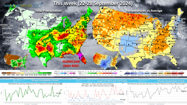
This week (22-28 Sep) shows the U.S. trending +0.8F warmer than last year, warmest in 5 years and 4th warmest of the past 39 years. The cooler more favorable spots are limited to the Southern Plains. Hot 90F days are down -25% and 32F days are the least in 39 years. Rainfall is up +19% the wettest in 6 years and 9th wettest of the past 39 years. The big headline event late this week will be a hurricane, potentially a major hurricane making landfall in the Northeast Gulf of Mexico.
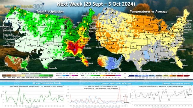
Next week (29 Sep - 5 Oct) trends -3F cooler than a year ago record hot week and 6th warmest of the past 39 years. Hot 90F days are down -74% vs last year and least in 14 years but 32F days are also down -73% and least in 39 years. Rainfall up +30%, wettest in 3 years and 18th wettest in 39 for the U.S. overall. wt360 expects a wetter October with continued high risk for hurricane threats.
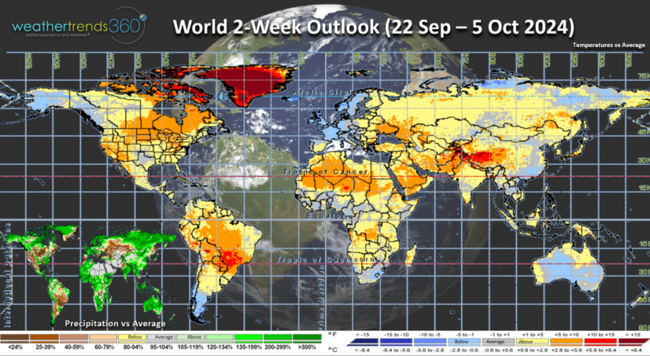
The World 2-week outlook (22 Sep - 5 Oct) shows some cooling up in Alaska which implies some cooler weather for the Lower 48 in a couple weeks. Europe cools down as well.
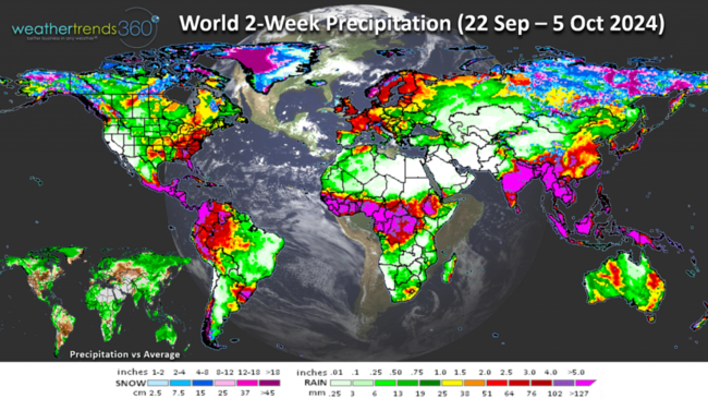
World rainfall (22 Sep - 5 Oct) shows very wet conditions across Africa and Latin America. The wet conditions in the Western Caribbean and Africa suggest plenty of moisture and ocean heat energy for an active end to the hurricane season.
Have a great week ahead, and don't forget to follow us on social media for frequent updates: Facebook, Twitter, YouTube, Pinterest and Linkedin.
- Captain Kirk out.
It's the last few hours of Summer 2024 as Fall officially arrives Sunday 22 Sep at 8:44am EDT. CLICK ON IMAGES FOR A LARGER VIEW

Day 112 of the 2024 hurricane season with 70 days to go. While the statistical metrics say the season is below average to date, the number of hurricane landfalls in the U.S. (3) is above the average of 2. This doesn't include potential tropical cyclone #8 that inundated North Carolina with major flooding.

Last year there was only 1 U.S. landfall despite 20 named storms, and we're very likely going to add a couple more landfalling hurricanes before the season is done.

The National Hurricane Center is monitoring 4 threat areas, but the Caribbean - Gulf threat is near certain to bring the next U.S. landfalling hurricane.

Almost all short-range models show a hurricane developing in the Gulf of Mexico where water temperatures are still near 87F, plenty of fuel for a rapidly developing system. Right now, the primary threat areas are from Alabama to Tampa Florida around Friday 27 Sept for a potential landfall. Tampa, FL has dodged MANY hurricanes over the past 176 years with only 2 major hurricane hits. The last major hurricane to hit Tampa was 103 years ago on 25 October 1921 and the one before that was the "Great Gale" CAT 4 Hurricane of 1848. TAMPA IS OVERDUE! The right front quadrant of any hurricane is significantly more dangerous and Tampa could be in that sector late this week. TBD

Last week (15-21 Sep) across the World shows the U.S. trending +4F warmer than last year, warmest in 6 years and 2nd warmest of the past 39 years. Rainfall was down -16%, least in 4 years and 4th driest in 39 years despite the major flooding in North Carolina from Potential Tropical Cyclone #8. Many argue this system should have been classified a landfalling Tropical Storm, it still might be after the National Hurricane Center reevaluates the data later this Fall. This time of year, colder/wetter conditions are more favorable for Fall merchandise sales. The West Coast was the most favorable area for Fall sales with the Eastern U.S. very unfavorable.

September rainfall has plummeted here in the Northeast after a wet August but now the driest first 21 days of September in over 40 years and in some cases the driest in 129 years. The North Central is equally dry while the South Central is the wettest in 6 years, the Southeast the wettest in 3 years. We always warn that droughts end in floods and hurricanes and that's likely to be theme for October in the East.

This week (22-28 Sep) shows the U.S. trending +0.8F warmer than last year, warmest in 5 years and 4th warmest of the past 39 years. The cooler more favorable spots are limited to the Southern Plains. Hot 90F days are down -25% and 32F days are the least in 39 years. Rainfall is up +19% the wettest in 6 years and 9th wettest of the past 39 years. The big headline event late this week will be a hurricane, potentially a major hurricane making landfall in the Northeast Gulf of Mexico.

Next week (29 Sep - 5 Oct) trends -3F cooler than a year ago record hot week and 6th warmest of the past 39 years. Hot 90F days are down -74% vs last year and least in 14 years but 32F days are also down -73% and least in 39 years. Rainfall up +30%, wettest in 3 years and 18th wettest in 39 for the U.S. overall. wt360 expects a wetter October with continued high risk for hurricane threats.

The World 2-week outlook (22 Sep - 5 Oct) shows some cooling up in Alaska which implies some cooler weather for the Lower 48 in a couple weeks. Europe cools down as well.

World rainfall (22 Sep - 5 Oct) shows very wet conditions across Africa and Latin America. The wet conditions in the Western Caribbean and Africa suggest plenty of moisture and ocean heat energy for an active end to the hurricane season.
Have a great week ahead, and don't forget to follow us on social media for frequent updates: Facebook, Twitter, YouTube, Pinterest and Linkedin.
- Captain Kirk out.