Captain's Blog 26 Jul '25 Major Cooling Trend Central and East
Captain's Log
26 July '25: Happy Saturday! :)
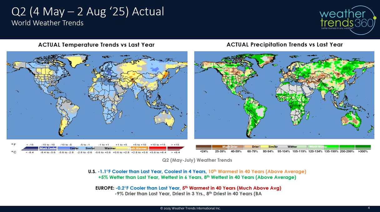
We provided a Q2-Q3 update for our Financial Services customers which showed a soft Q2 but the potential for a much stronger Q3. The Q2 (May - Jul) shows the U.S. actually trending -1.1F cooler than last year (1oth warmest in 40 years) and +5% wetter, wettest in 6 years for the U.S. overall. Soft trends for Summer seasonal categories up against the extreme heat and drought last year. CLICK ON IMAGES FOR A LARGER VIEW.

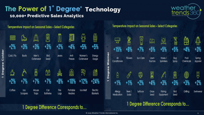
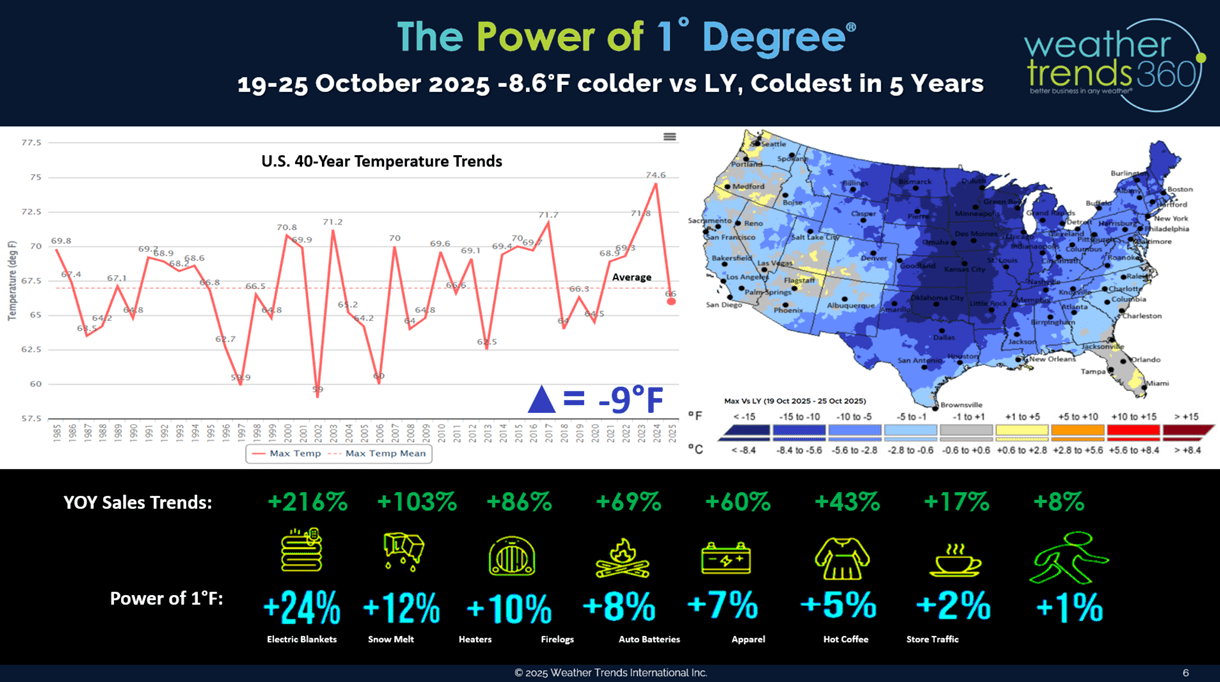
We discussed our Power of 1 Degree technology and how it quantifies weather's influence on thousands of season sales.
Using the wt360 long range forecast for the 19-25th of October 2025 shows national temperatures likely to trend -9F cooler YOY resulting in strong demand for early Fall Seasonal merchandise.

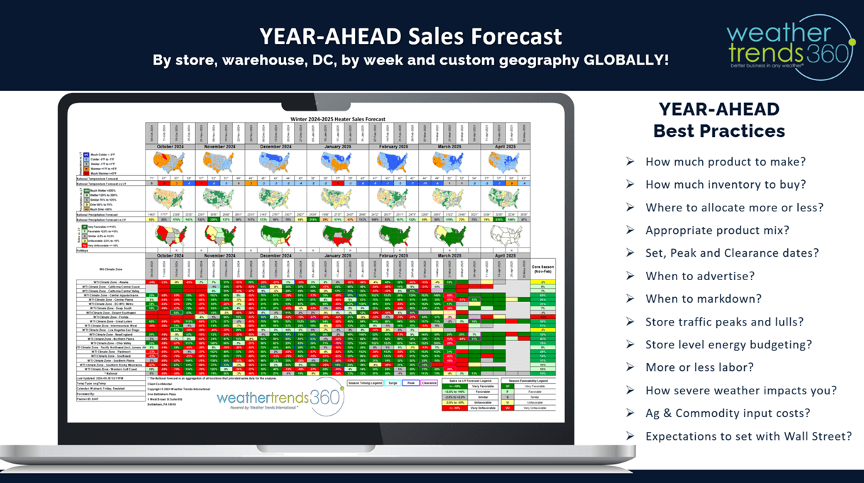
The outputs of the technology show week-by-week, store or warehouse sales forecasts out 11 months to help plan inventory, allocation, marketing, advertising timing, etc.

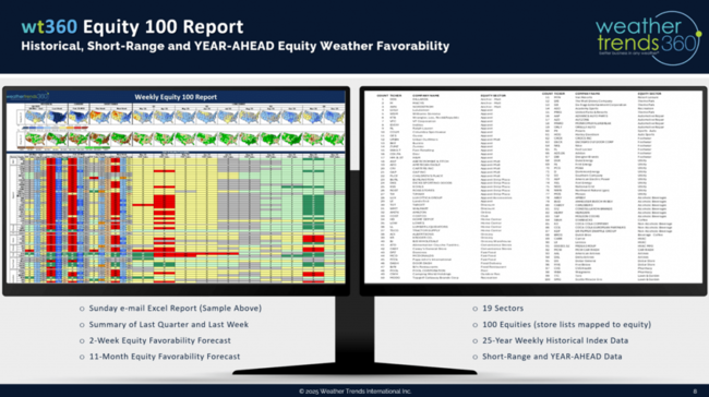
Of course, our 100 Equity favorability forecast out three quarters is always a big hit with the financial services industry.
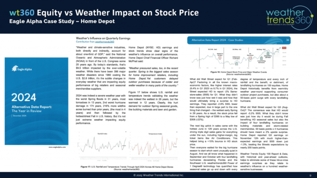
We published an article in Eagle Alpha showing how weather influences sales and ultimately stock price with a Home Depot example.
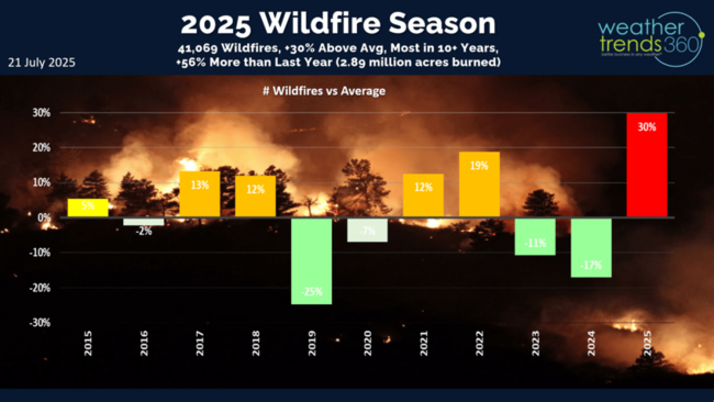
Back to the weather...wildfire numbers remain high up +30% above average, the most in over 10 years and +56% more than last year. This will become a bigger theme over the next few months out West.
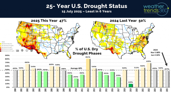
Drought has shifted West and North, but overall only 47% of the U.S. is in dry to drought phases. This is the least drought coverage in 6 years. Notice the East Coast drought from last year is completely gone.
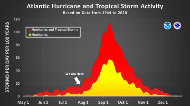
Need to start watching the Atlantic for hurricane development as we're entering a very favorable MJO tropical convective cycle. Some models already hint at a system in early August near the East Coast up to New England.

Oceanic water temperatures show a pocket of much warmer waters off the East Coast, one of our high threat areas for 2025.

Models suggest we remain in an ENSO neutral phase into early 2026 which favors tropical development in the Atlantic Basin.
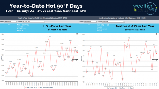
Hot 90F days to date are down -4% vs last year nationally and down -17% in the Northeast.
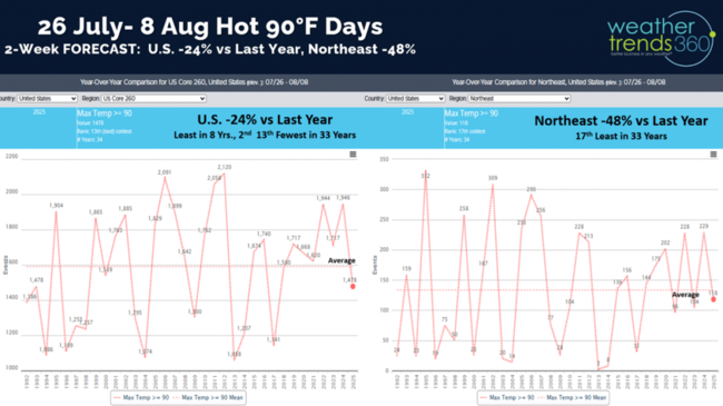
The 2-week forecast for days over 90F shows a dramatically cooler period ahead with hot 90F days down -24% nationally, least in 8 years. The Northeast down -48% vs LY.
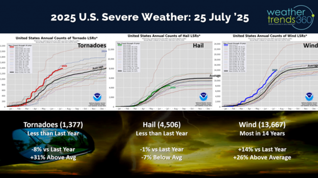
Tornadoes still trending down -8% vs last year, hail down -1% while wind cases are still +14% above last year.

The 4-day severe weather outlook shows some risk for the Northern Plains and maybe the Middle Atlantic on Sunday.
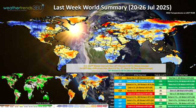
Last week (20-26 July) across the World shows the U.S. trending +2.2F warmer than last year and 10th warmest of the past 40 years. Hot 90F days were up +54%, most in 3 years and 6th most in 40 years. Rainfall down -20% vs LY but still 16th wettest in 40 years. This was a more favorable week for Summer seasonal category sales. Cool and Wet across Canada, except in the East.
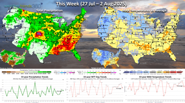
This week (27 Jul - 2 Aug) shows the Canadian cooler air invading the Central U.S. and the Northeast later in the week. Warm out ahead of this cold front in the South and East. The U.S. overall trends -2.4F cooler than last year, coolest in 7 years and 15th coolest in 33 years. Still hot/steamy in the South ahead of the front with widespread thunderstorms in the Southeast. Hot 90F days down -15% and least in 7 years, while rainfall is down -4% but still 13th wettest of the past 33 years.

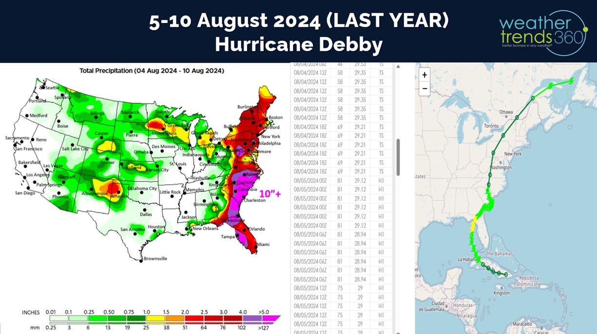
Next week (3-9 Aug) shows the dramatic cool down from Montana to Georgia and points North. The West heats up. The U.S. overall trending -1.6F cooler than last year, coolest in 8 years and 12th coolest of the past 33. Hot 90F days down -38% vs LY, least in 8 years, while rainfall is down -48% vs last year when Hurricane Debby drenched the Southeast.

Need to watch the tropics as models hint at development in early August off the East Coast. Tropical activity ramps up significantly in August with the core of the hurricane season Aug - Oct.
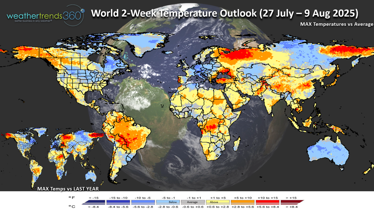
The World 2-week Temperature outlook (27 Jul - 9 Aug) shows cooler trends for Eastern North America while the West warms up. Cooler trends across Europe and Australia, while Brazil gets hot.

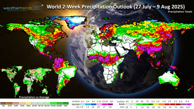
The World 2-week Precipitation outlook (27 Jul - 9 Aug) shows above average rainfall across the Southeast and Corn Belt into the Pacific Northwest. Wetter in Eastern Europe, drier Western Europe.
Have a great week ahead and don't forget to follow us on social media for frequent updates: Facebook, Twitter(X), YouTube, Pinterest and Linkedin.
- Captain Kirk out
We provided a Q2-Q3 update for our Financial Services customers which showed a soft Q2 but the potential for a much stronger Q3. The Q2 (May - Jul) shows the U.S. actually trending -1.1F cooler than last year (1oth warmest in 40 years) and +5% wetter, wettest in 6 years for the U.S. overall. Soft trends for Summer seasonal categories up against the extreme heat and drought last year. CLICK ON IMAGES FOR A LARGER VIEW.
We discussed our Power of 1 Degree technology and how it quantifies weather's influence on thousands of season sales.

Using the wt360 long range forecast for the 19-25th of October 2025 shows national temperatures likely to trend -9F cooler YOY resulting in strong demand for early Fall Seasonal merchandise.
The outputs of the technology show week-by-week, store or warehouse sales forecasts out 11 months to help plan inventory, allocation, marketing, advertising timing, etc.
Of course, our 100 Equity favorability forecast out three quarters is always a big hit with the financial services industry.

We published an article in Eagle Alpha showing how weather influences sales and ultimately stock price with a Home Depot example.

Back to the weather...wildfire numbers remain high up +30% above average, the most in over 10 years and +56% more than last year. This will become a bigger theme over the next few months out West.

Drought has shifted West and North, but overall only 47% of the U.S. is in dry to drought phases. This is the least drought coverage in 6 years. Notice the East Coast drought from last year is completely gone.

Need to start watching the Atlantic for hurricane development as we're entering a very favorable MJO tropical convective cycle. Some models already hint at a system in early August near the East Coast up to New England.
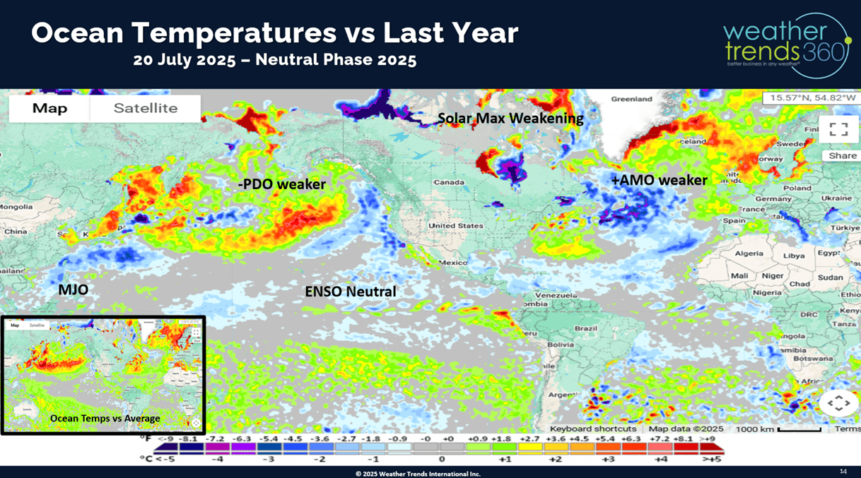
Oceanic water temperatures show a pocket of much warmer waters off the East Coast, one of our high threat areas for 2025.
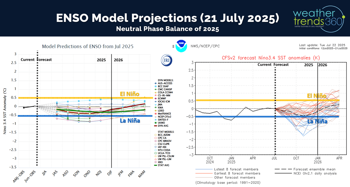
Models suggest we remain in an ENSO neutral phase into early 2026 which favors tropical development in the Atlantic Basin.
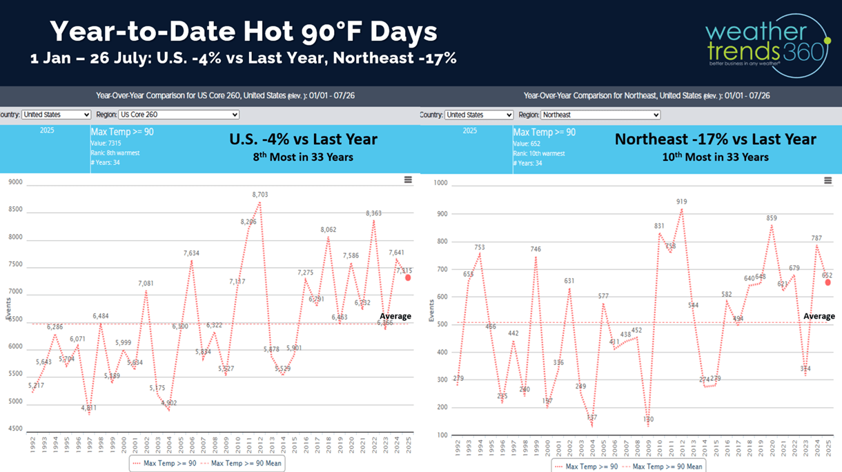
Hot 90F days to date are down -4% vs last year nationally and down -17% in the Northeast.
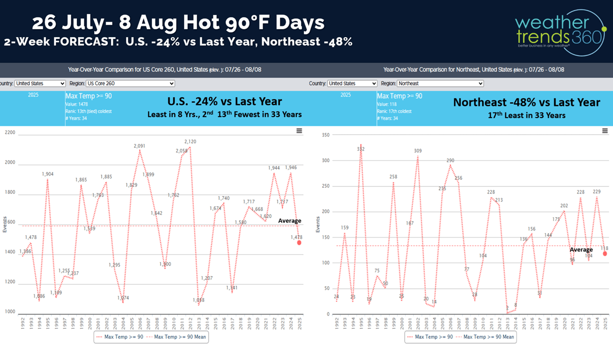
The 2-week forecast for days over 90F shows a dramatically cooler period ahead with hot 90F days down -24% nationally, least in 8 years. The Northeast down -48% vs LY.

Tornadoes still trending down -8% vs last year, hail down -1% while wind cases are still +14% above last year.
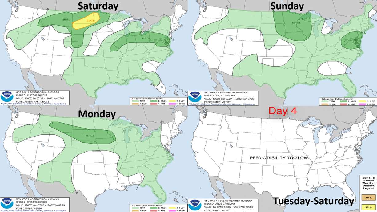
The 4-day severe weather outlook shows some risk for the Northern Plains and maybe the Middle Atlantic on Sunday.
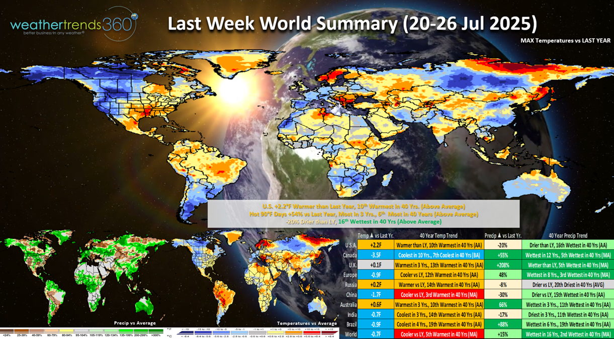
Last week (20-26 July) across the World shows the U.S. trending +2.2F warmer than last year and 10th warmest of the past 40 years. Hot 90F days were up +54%, most in 3 years and 6th most in 40 years. Rainfall down -20% vs LY but still 16th wettest in 40 years. This was a more favorable week for Summer seasonal category sales. Cool and Wet across Canada, except in the East.
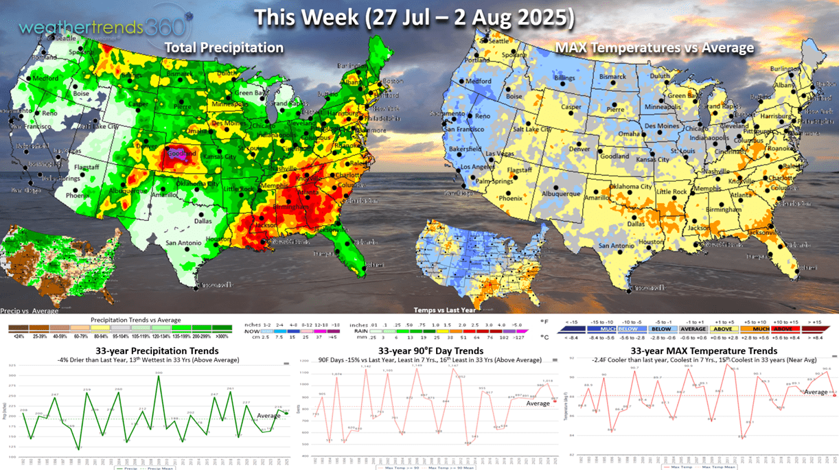
This week (27 Jul - 2 Aug) shows the Canadian cooler air invading the Central U.S. and the Northeast later in the week. Warm out ahead of this cold front in the South and East. The U.S. overall trends -2.4F cooler than last year, coolest in 7 years and 15th coolest in 33 years. Still hot/steamy in the South ahead of the front with widespread thunderstorms in the Southeast. Hot 90F days down -15% and least in 7 years, while rainfall is down -4% but still 13th wettest of the past 33 years.
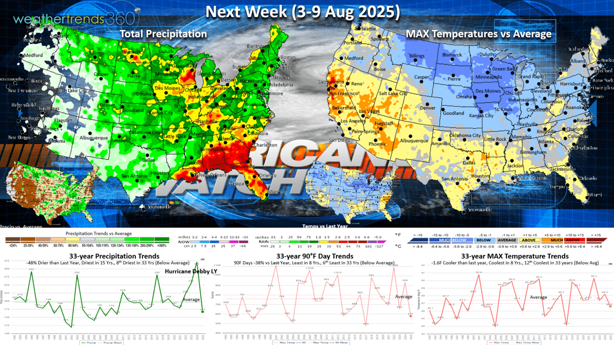
Next week (3-9 Aug) shows the dramatic cool down from Montana to Georgia and points North. The West heats up. The U.S. overall trending -1.6F cooler than last year, coolest in 8 years and 12th coolest of the past 33. Hot 90F days down -38% vs LY, least in 8 years, while rainfall is down -48% vs last year when Hurricane Debby drenched the Southeast.
Need to watch the tropics as models hint at development in early August off the East Coast. Tropical activity ramps up significantly in August with the core of the hurricane season Aug - Oct.

The World 2-week Temperature outlook (27 Jul - 9 Aug) shows cooler trends for Eastern North America while the West warms up. Cooler trends across Europe and Australia, while Brazil gets hot.
The World 2-week Precipitation outlook (27 Jul - 9 Aug) shows above average rainfall across the Southeast and Corn Belt into the Pacific Northwest. Wetter in Eastern Europe, drier Western Europe.

Have a great week ahead and don't forget to follow us on social media for frequent updates: Facebook, Twitter(X), YouTube, Pinterest and Linkedin.
- Captain Kirk out