Captain's Blog 5 Jul '25 Volatile Dog Days of Summer
Captain's Log
5 July '25: Happy Saturday. :)
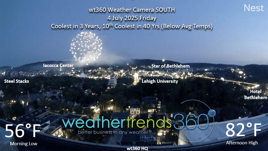
We hope you're having a great Independence Day July 4th weekend! The Bethlehem PA fireworks are launched near Lehigh University just a few blocks from wt360 HQ. We had a perfect cool'ish and dry day. CLICK ON IMAGES FOR A LARGER VIEW.

Not so on 3 July when a cluster of severe thunderstorms dumped up to 2.5" of rain in Eastern PA with wind gusts over 60 mph in spots.
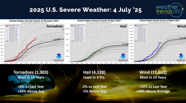
Severe weather to date still shows tornadoes and wind cases trending the most in 14 years, while hail is trending least in 3 years.
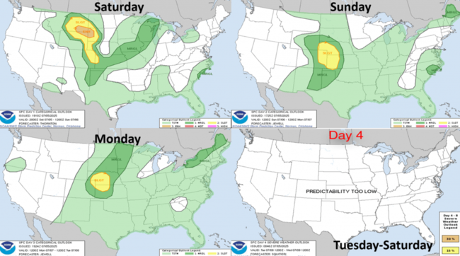
The 4-day severe weather outlook (5-8 Jul) shows the Plains having the highest risk for severe weather.

The 2025 Hurricane season is off to an active start with the 3rd name storm (Chantal) making landfall around 3am Sunday morning well north of Charleston in a not so populated area. Impacts are expected to be minimal other than some spotty flash flooding.

Hot 90F days year-t0-date show the U.S. down -6% vs last year and the Northeast down -19% vs last year.
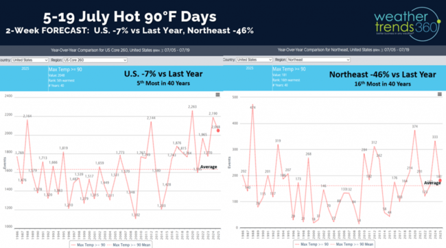
The next 2-weeks (5-19 July) show hot 90F days down -7% for the U.S. and -46% for the Northeast vs last year.
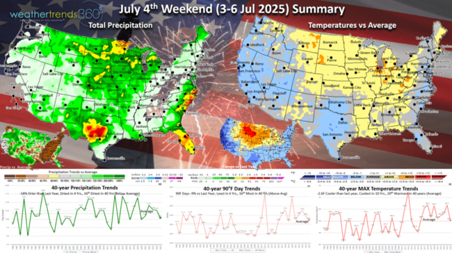
The July 4th weekend (3-6 July) will likely end up -2.6F cooler than last year, coolest in 10 years and 20th warmest of the past 40 years. Hot 90F days down -9% vs LY but 16th most of the past 40 years, while rainfall is trending down -18% vs LY, driest in 4 years and 16th driest in 40 years. The dry weather is great for outdoor activities and consumable categories like picnic food categories, pool supplies, grilling, etc.
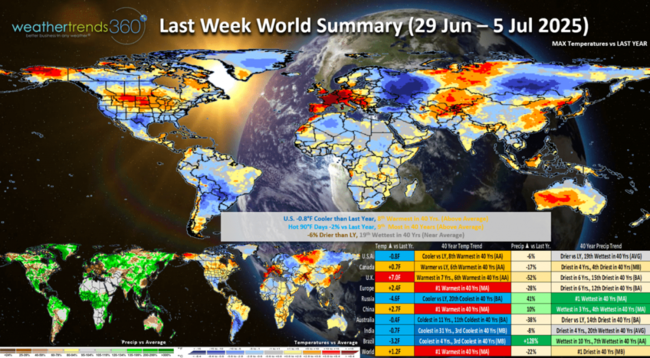
Last week (29 Jun - 5 Jul) across the World shows the U.S. trending -0.8F cooler vs last year, but still 8th warmest of the past 40 years. There was a major cooling trend in the East toward the end of the week. Hot 90F days down -2% vs LY, but still 9th most of the past 40 years. Rainfall was down -6% vs LY and 19th wettest of the past 40 years. These were favorable trends for hot seasonal category sales, but growth somewhat limited in light of even more extremely hot conditions last year. Europe had exceptional weather for Summer categories trending #1 hottest in over 40 years, while India trended the coolest in 31 years. This time of year hotter/drier weather is better for most Summer categories and consumable food and beverage categories.
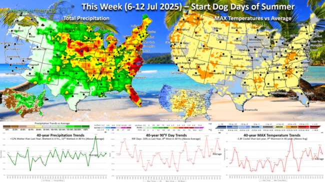
This week (6-12 July) shows the U.S. trending -1.8F cooler than last year and 9th warmest of the past 40 years. East Coast and West Coast cooler than LY, while the hotter conditions are in the Central U.S. and Rockies. Hot 90F days down -16% vs LY and rainfall up +12% and wettest in 40 years. These are slightly negative trends for Summer seasonal categories.

Next week (13-19 July) shows national temperatures trending +0.2F warmer than last year, warmest in 19 years and 3rd warmest in 40 years. Hot 90F days +12% vs last year and #1 most in 40 years, while rainfall is up +11% and 12th wettest of the pat 40 years. Ample rainfall continues across the entire Corn Belt likely leading to record crop yields!
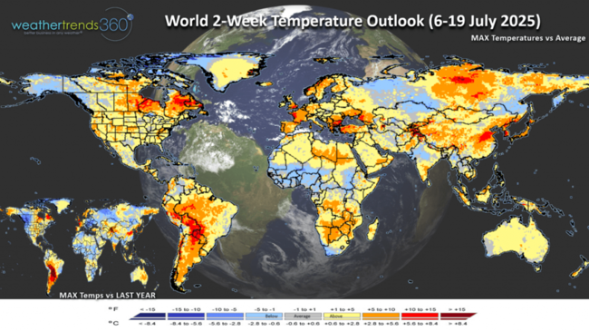
The World 2-week Temperature outlook (6-19 July) shows most of North America and Europe on the warm side benefiting Summer seasonal sales.

The World 2-week Precipitation outlook (6-19 July) shows wet conditions from the Midwest to the East Coast and very dry in the West. Wildfires in the West will be an increasing threat through Summer and early Fall.
We hope you have a great week ahead. Don't forget to follow us on social media for frequent updates: Facebook, Twitter, YouTube, Pinterest and Linkedin.
- Captain Kirk out
We hope you're having a great Independence Day July 4th weekend! The Bethlehem PA fireworks are launched near Lehigh University just a few blocks from wt360 HQ. We had a perfect cool'ish and dry day. CLICK ON IMAGES FOR A LARGER VIEW.
Not so on 3 July when a cluster of severe thunderstorms dumped up to 2.5" of rain in Eastern PA with wind gusts over 60 mph in spots.
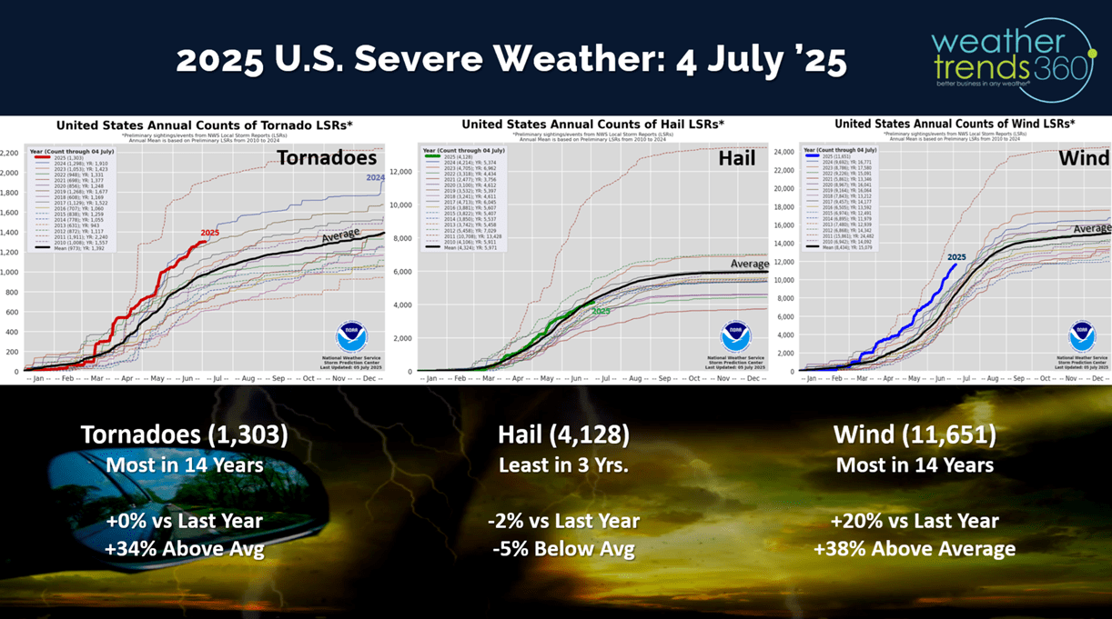
Severe weather to date still shows tornadoes and wind cases trending the most in 14 years, while hail is trending least in 3 years.

The 4-day severe weather outlook (5-8 Jul) shows the Plains having the highest risk for severe weather.
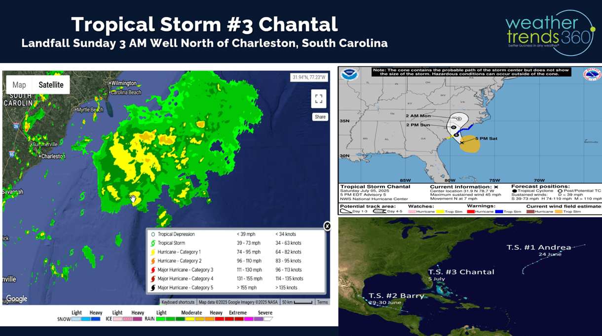
The 2025 Hurricane season is off to an active start with the 3rd name storm (Chantal) making landfall around 3am Sunday morning well north of Charleston in a not so populated area. Impacts are expected to be minimal other than some spotty flash flooding.
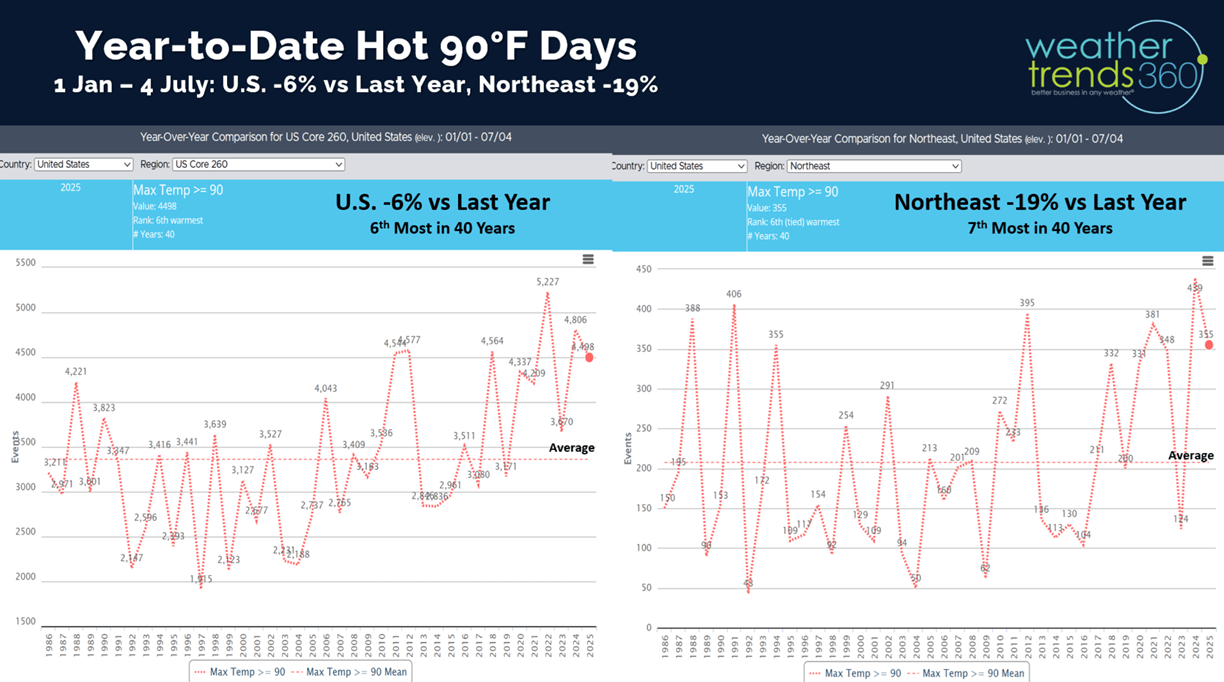
Hot 90F days year-t0-date show the U.S. down -6% vs last year and the Northeast down -19% vs last year.

The next 2-weeks (5-19 July) show hot 90F days down -7% for the U.S. and -46% for the Northeast vs last year.
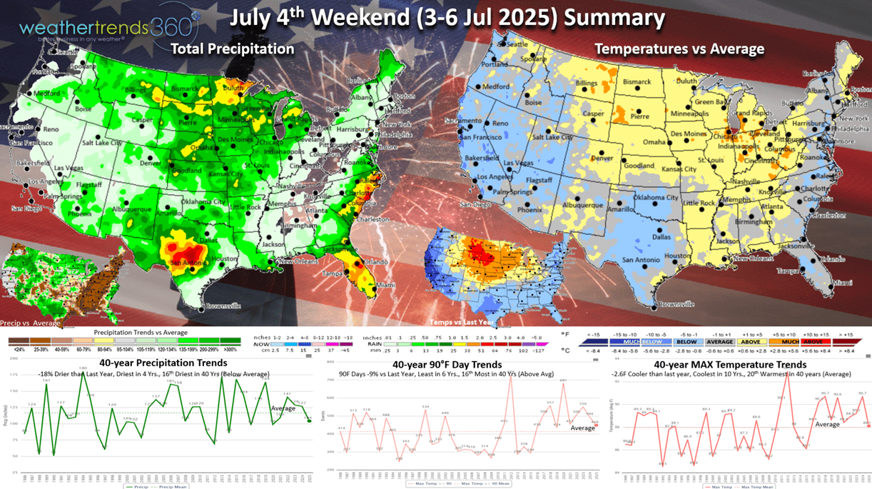
The July 4th weekend (3-6 July) will likely end up -2.6F cooler than last year, coolest in 10 years and 20th warmest of the past 40 years. Hot 90F days down -9% vs LY but 16th most of the past 40 years, while rainfall is trending down -18% vs LY, driest in 4 years and 16th driest in 40 years. The dry weather is great for outdoor activities and consumable categories like picnic food categories, pool supplies, grilling, etc.

Last week (29 Jun - 5 Jul) across the World shows the U.S. trending -0.8F cooler vs last year, but still 8th warmest of the past 40 years. There was a major cooling trend in the East toward the end of the week. Hot 90F days down -2% vs LY, but still 9th most of the past 40 years. Rainfall was down -6% vs LY and 19th wettest of the past 40 years. These were favorable trends for hot seasonal category sales, but growth somewhat limited in light of even more extremely hot conditions last year. Europe had exceptional weather for Summer categories trending #1 hottest in over 40 years, while India trended the coolest in 31 years. This time of year hotter/drier weather is better for most Summer categories and consumable food and beverage categories.
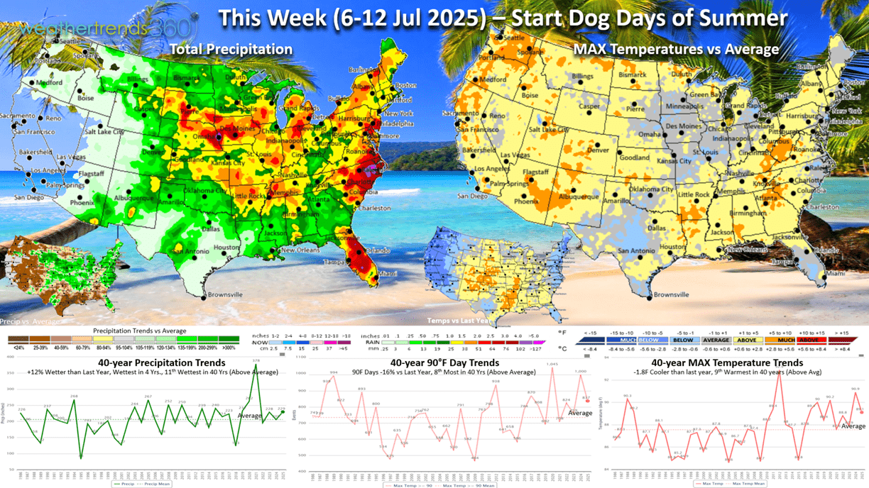
This week (6-12 July) shows the U.S. trending -1.8F cooler than last year and 9th warmest of the past 40 years. East Coast and West Coast cooler than LY, while the hotter conditions are in the Central U.S. and Rockies. Hot 90F days down -16% vs LY and rainfall up +12% and wettest in 40 years. These are slightly negative trends for Summer seasonal categories.
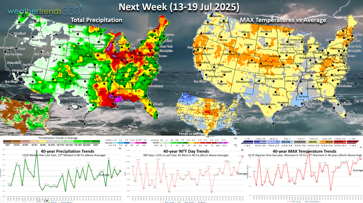
Next week (13-19 July) shows national temperatures trending +0.2F warmer than last year, warmest in 19 years and 3rd warmest in 40 years. Hot 90F days +12% vs last year and #1 most in 40 years, while rainfall is up +11% and 12th wettest of the pat 40 years. Ample rainfall continues across the entire Corn Belt likely leading to record crop yields!

The World 2-week Temperature outlook (6-19 July) shows most of North America and Europe on the warm side benefiting Summer seasonal sales.
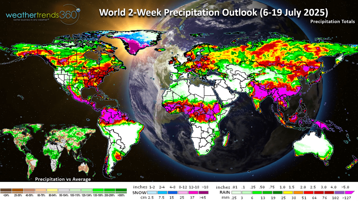
The World 2-week Precipitation outlook (6-19 July) shows wet conditions from the Midwest to the East Coast and very dry in the West. Wildfires in the West will be an increasing threat through Summer and early Fall.
We hope you have a great week ahead. Don't forget to follow us on social media for frequent updates: Facebook, Twitter, YouTube, Pinterest and Linkedin.
- Captain Kirk out