Captain's Blog 6 Sep '25 Another Cool Week Then Warmer
Captain's Log
6 Sep '25: Happy Saturday! :)
If you love everything agriculture, farming and weather, check out the Women in Agribusiness conference in Orlando 22-24 September. I'll be speaking on our year-ahead global outlook for farmers...some good news...a lot of bad news. CLICK ON IMAGES FOR A LARGER VIEW

Some concern for farmers in 2026 will be better crops out of Brazil further impacting already low prices, but then maybe some upward movement with a cold Spring with lates frosts and driest growing season in 3 years.
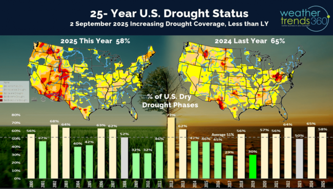
Dry to drought conditions to date made a bigger move drier with 58% of the country now in dry to drought phases, but this is still down from last year when 65% was dry. Average this time of year is about 51% of the U.S. in drier phases.

Just as Summer is ending here in the Northern Hemisphere, Winter is ending down under in Australia where they had a less severe Flu season. One reason for the less severe conditions was a warmer start to Winter but then a much cooler August. The peak was very late in middle August this year with a Type B predominant strain after a couple years in a row with Type A. Type B is usually less severe than Type A. This is one predictor for the U.S. season.

The CDC shows U.S. Flu off to the slowest start in 5 years, but this could ramp up quickly in the months ahead with a colder Fall. Last year's very hot Fall resulted in a very slow start to the season with a very late peak in February.

This year likely to start several weeks earlier with the coolest Fall in 3 years and wettest in 5 years, but another late season peak.

With the expanding dry weather in the West this year, wildfires are up +35% over last year, +12% above average, the most in 3 years and 2nd most in 10 years. This will remain a concern for the next couple months out West.

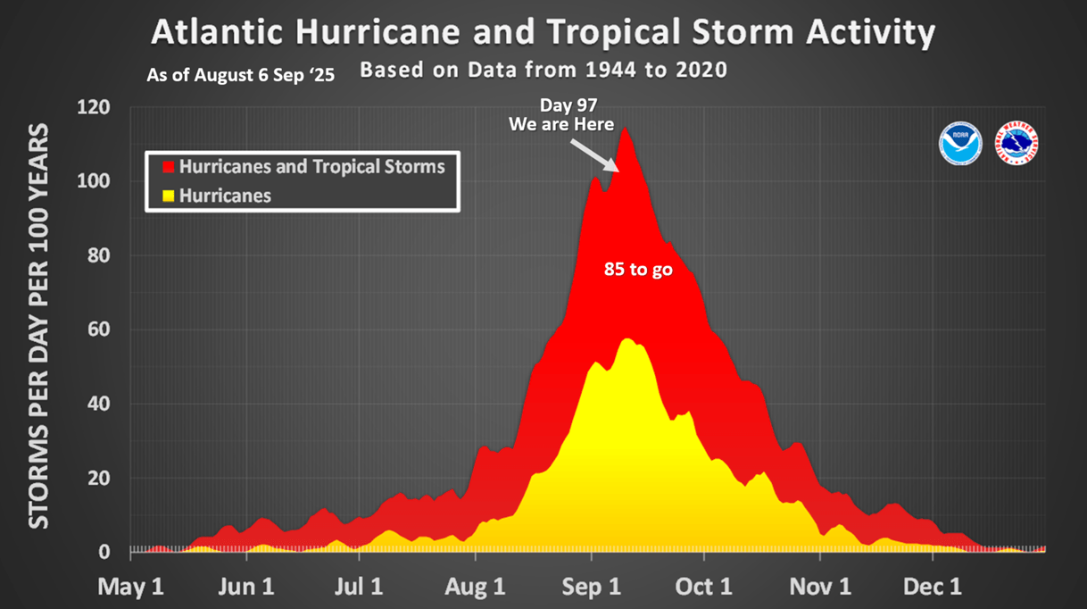
We are nearing the peak of the hurricane season here on day 97, but for now only one system of concern out in the Atlantic. There are still 85 days left in the season and an MJO convective pulse cycle is becoming more favorable for activity in the Gulf/Atlantic.

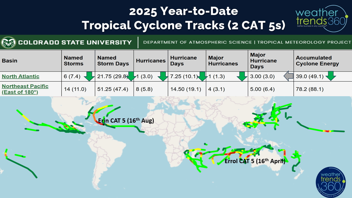
World tropical storm tracks only show two Cat 5s this year with the Atlantic basin now trending slightly below average to date.

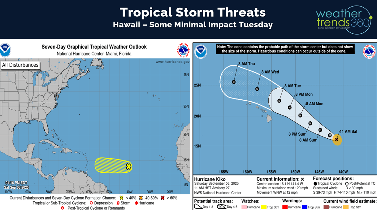
Hawaii will get grazed to the North from Hurricane Kiko, but the southside of the storm is much weaker than the Northeast quadrant, so not a major impact.
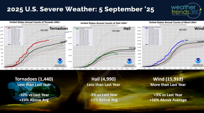
Severe Weather season continues to flat line with Tornadoes and Hail down vs last year, only Wind cases are still trending up over LY.

The weekly severe weather outlook shows a cold front sweeping off the East Coast with some severe weather ending tonight.

Soon we'll be talking cold and snow trends, but hot 90F days year-to-date in the U.S. are down -7% vs last year, while the Northeast is down -17% vs LY.

The 2-week outlook for hot days show the U.S. continuing to trend down -35% vs LY and the Northeast -81% vs last year.

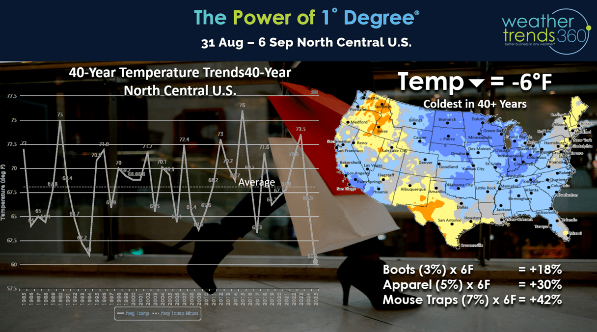
Last week (31 Aug - 6 Sep) - week before Labor Day was -2.6F cooler than LY in the U.S., coolest in 16 years and 8th coolest of the past 40 years. Hot 90F days down -18%, least in 8 years, while rainfall was down -31% vs LY. These are very favorable trends for Fall seasonal merchandise sales and store traffic.

Our Power of 1 Degree technology quantifies this weather's influence on sales with every 1F cooler bringing a 3% bounce in boot sales, 5% in apparel sales and 7% in mouse trap sales - YUP - mice start to move into your sheds, garages, homes as it gets cooler.

Applying these metrics to the very cold North Central U.S. (coldest in over 40 years) and -6F cooler than LY would bring a +18% bounce in boot sales, +30% for apparel and +42% for mouse traps just due to much colder weather.
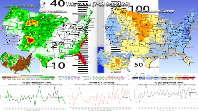
This week (7-13 Sep) shows the cooler weather hanging on in the East, but a warming trend in the North Central U.S. The U.S. overall still trends -0.8F cooler than a year ago, coolest in 5 years and 16th coolest in 40 years. Hot 90F days down -20% and least in 8 years, while rainfall is down -32% nationally and least in 20 years. Need to watch Florida late week for the potential for some tropical impacts.
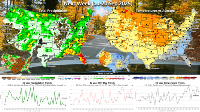
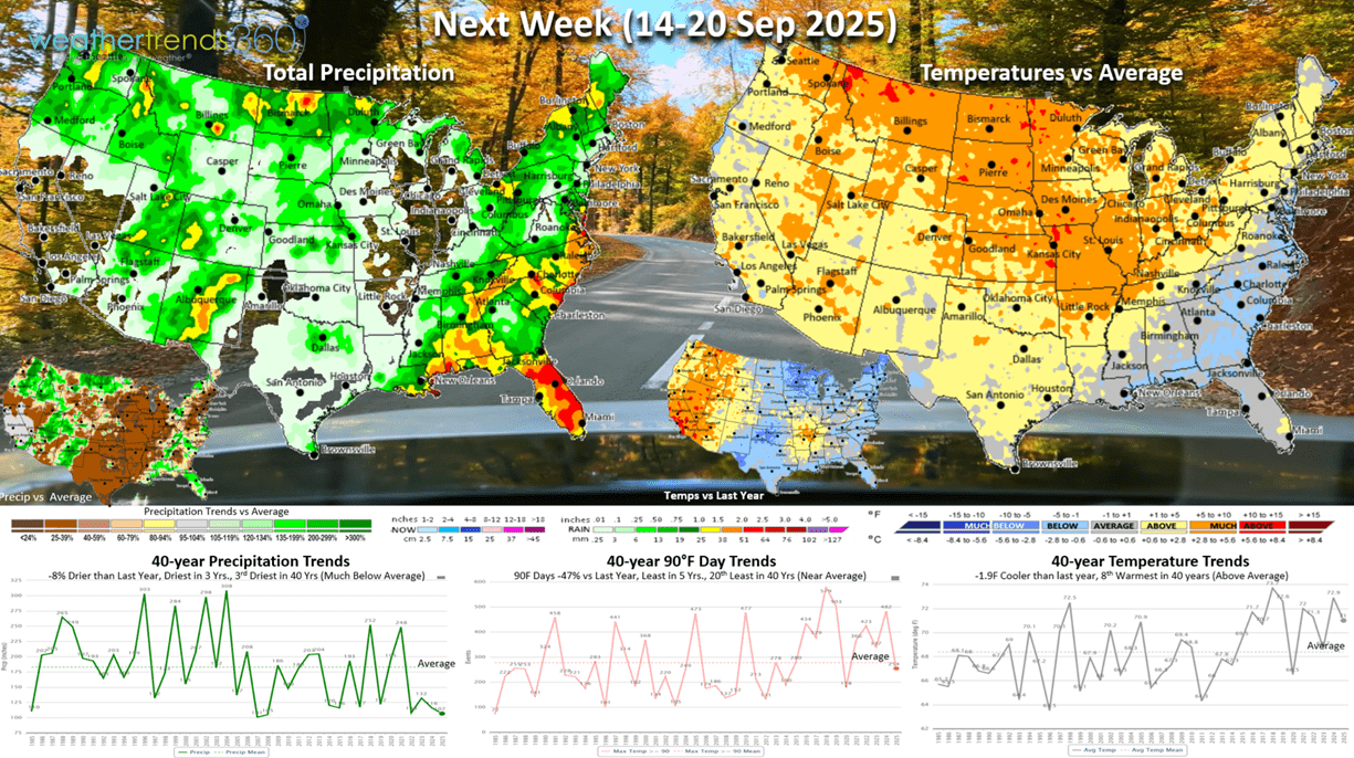
Next week (14-20 Sep) is the last week of Summer and the weather cooperates with all but the Southeast showing above average temperatures. It's still -1.9F cooler nationally than a year ago but 8th warmest of the past 40 years. Hot 90F days down -47% and least in 5 years, with rainfall the 3rd least in 40 years. Still need to watch the tropics as conditions are favorable for something to develop quickly with a stalled cold front in the South.

The World 2-week Temperature outlook (7-20 Sep) shows a warming trend in the U.S. and Western Canada with cooler conditions in Central Europe.

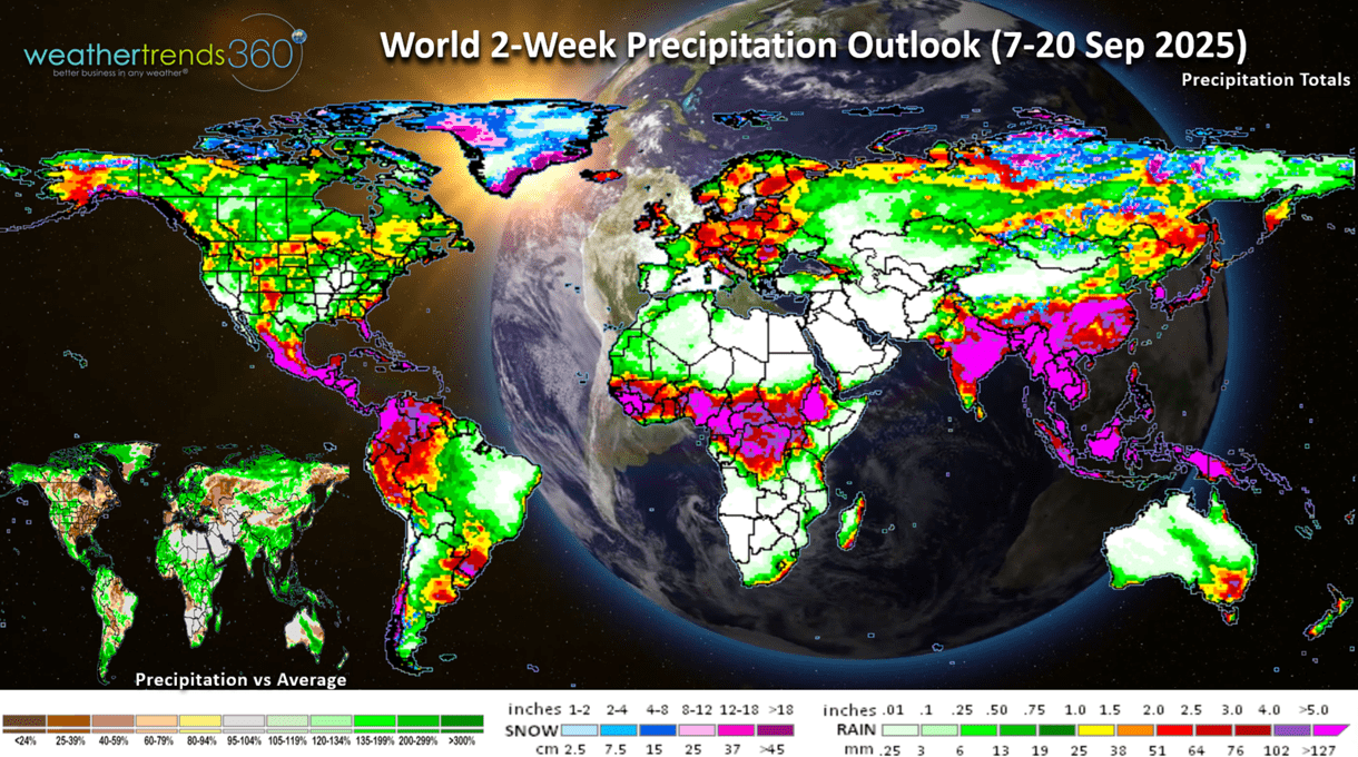
The World 2-week Precipitation outlook (7-20 Sep) shows below average rainfall for the Eastern half of the U.S. which is good for farmers starting harvest. Dry in Western Europe, wet Eastern Europe. This time of year cooler and wetter weather is better for overall Fall seasonal merchandise sales.
Have a great week ahead, and don't forget to follow us on social media for frequent updates: Facebook, Twitter(X), YouTube, Pinterest and Linkedin.
- Captain Kirk out
If you love everything agriculture, farming and weather, check out the Women in Agribusiness conference in Orlando 22-24 September. I'll be speaking on our year-ahead global outlook for farmers...some good news...a lot of bad news. CLICK ON IMAGES FOR A LARGER VIEW

Some concern for farmers in 2026 will be better crops out of Brazil further impacting already low prices, but then maybe some upward movement with a cold Spring with lates frosts and driest growing season in 3 years.
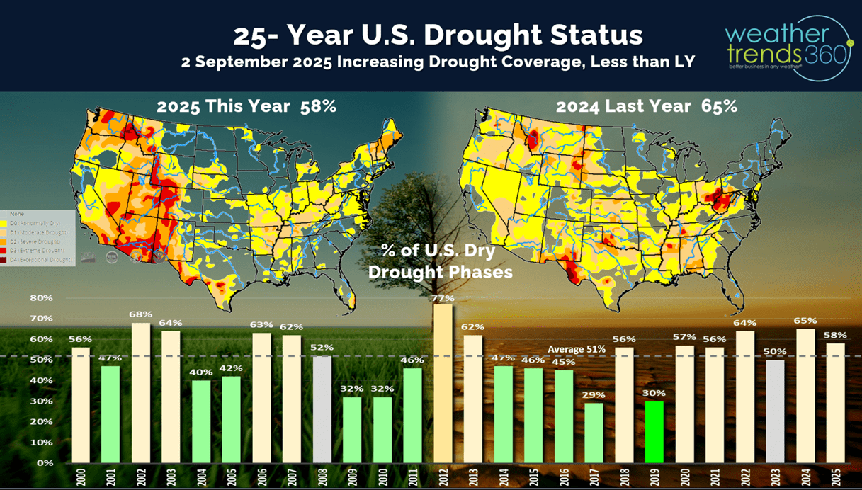
Dry to drought conditions to date made a bigger move drier with 58% of the country now in dry to drought phases, but this is still down from last year when 65% was dry. Average this time of year is about 51% of the U.S. in drier phases.
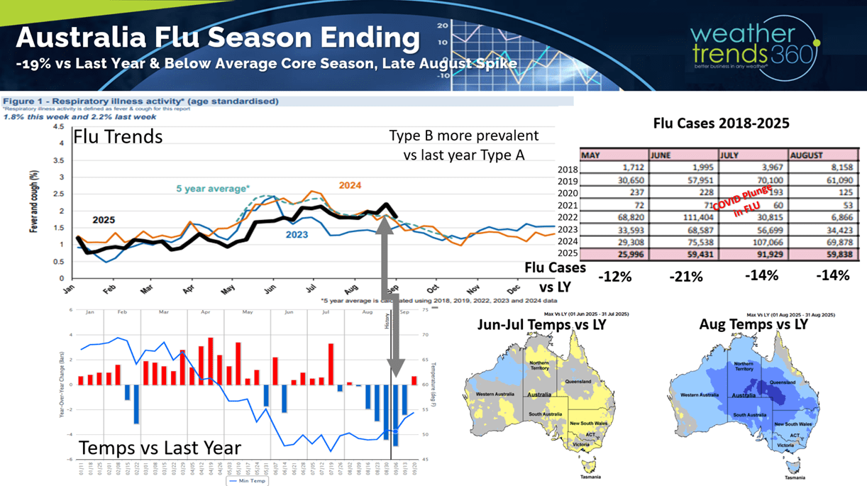
Just as Summer is ending here in the Northern Hemisphere, Winter is ending down under in Australia where they had a less severe Flu season. One reason for the less severe conditions was a warmer start to Winter but then a much cooler August. The peak was very late in middle August this year with a Type B predominant strain after a couple years in a row with Type A. Type B is usually less severe than Type A. This is one predictor for the U.S. season.
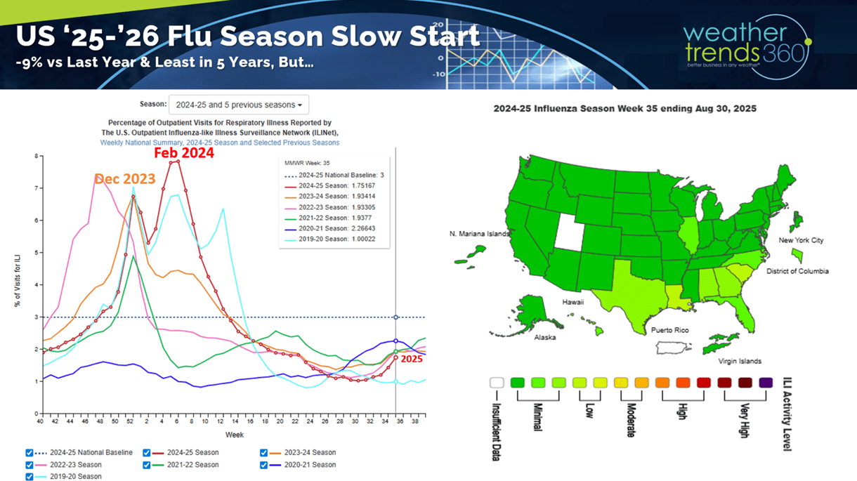
The CDC shows U.S. Flu off to the slowest start in 5 years, but this could ramp up quickly in the months ahead with a colder Fall. Last year's very hot Fall resulted in a very slow start to the season with a very late peak in February.
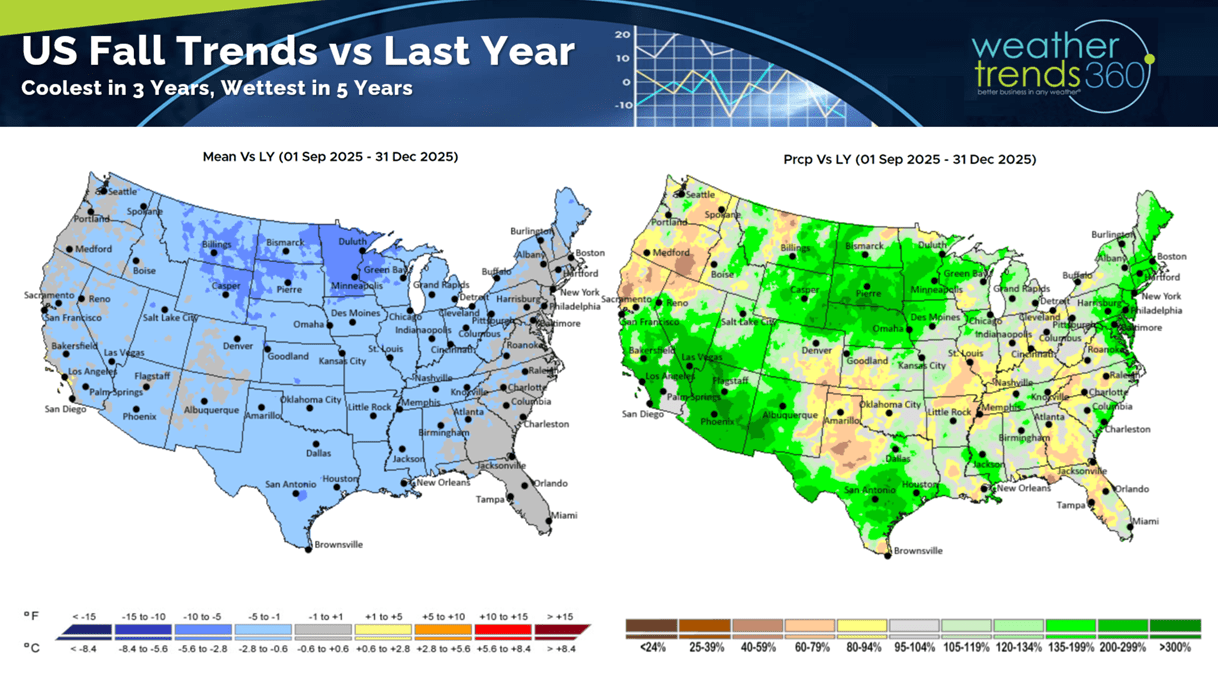
This year likely to start several weeks earlier with the coolest Fall in 3 years and wettest in 5 years, but another late season peak.
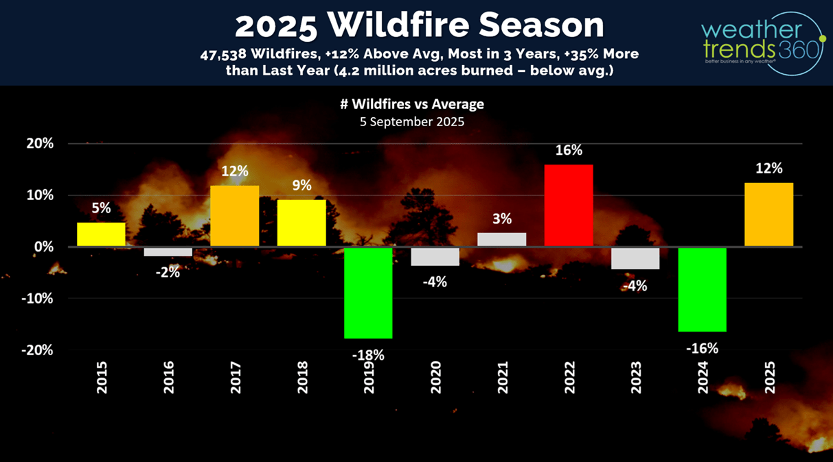
With the expanding dry weather in the West this year, wildfires are up +35% over last year, +12% above average, the most in 3 years and 2nd most in 10 years. This will remain a concern for the next couple months out West.
We are nearing the peak of the hurricane season here on day 97, but for now only one system of concern out in the Atlantic. There are still 85 days left in the season and an MJO convective pulse cycle is becoming more favorable for activity in the Gulf/Atlantic.
World tropical storm tracks only show two Cat 5s this year with the Atlantic basin now trending slightly below average to date.
Hawaii will get grazed to the North from Hurricane Kiko, but the southside of the storm is much weaker than the Northeast quadrant, so not a major impact.

Severe Weather season continues to flat line with Tornadoes and Hail down vs last year, only Wind cases are still trending up over LY.
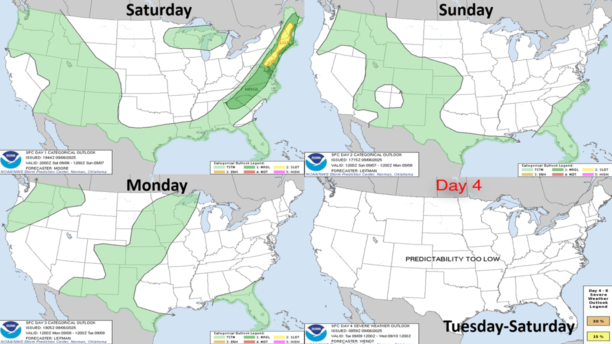
The weekly severe weather outlook shows a cold front sweeping off the East Coast with some severe weather ending tonight.
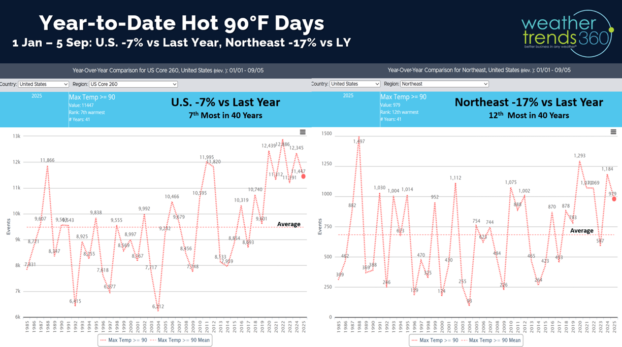
Soon we'll be talking cold and snow trends, but hot 90F days year-to-date in the U.S. are down -7% vs last year, while the Northeast is down -17% vs LY.
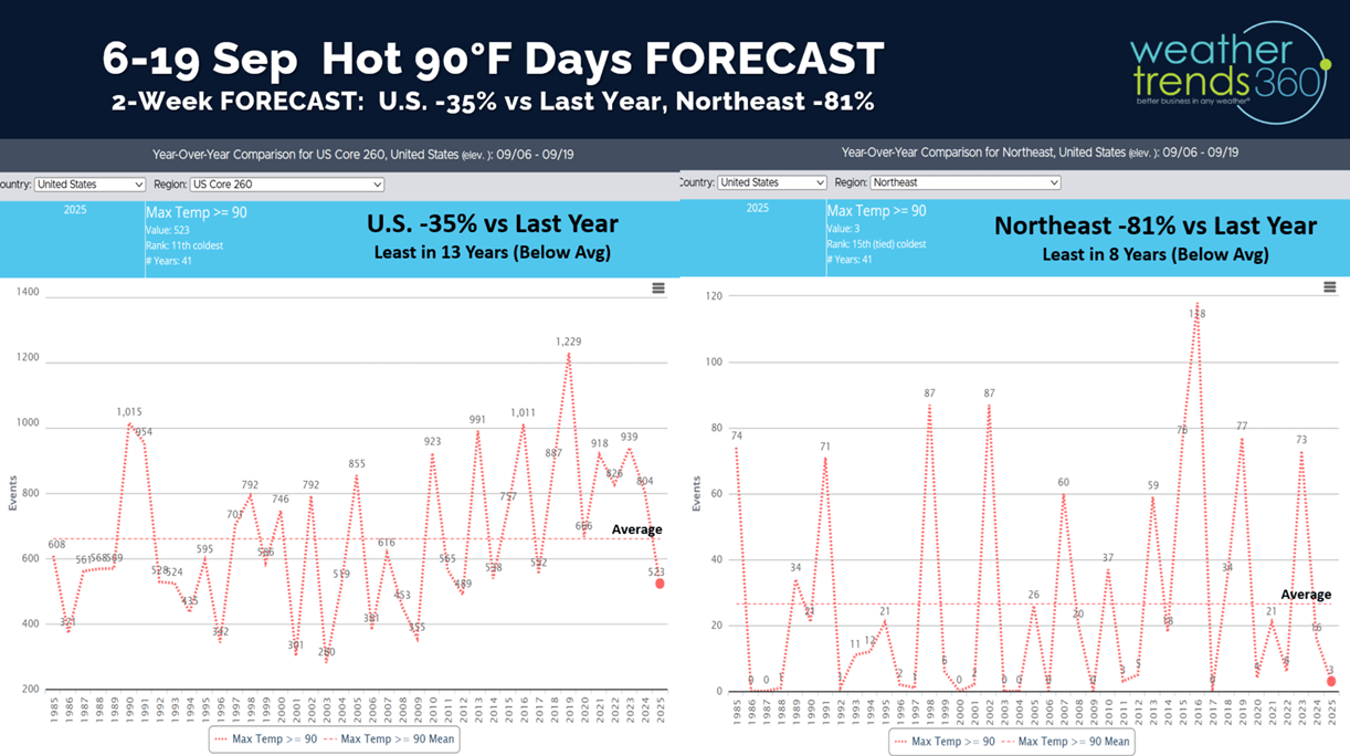
The 2-week outlook for hot days show the U.S. continuing to trend down -35% vs LY and the Northeast -81% vs last year.
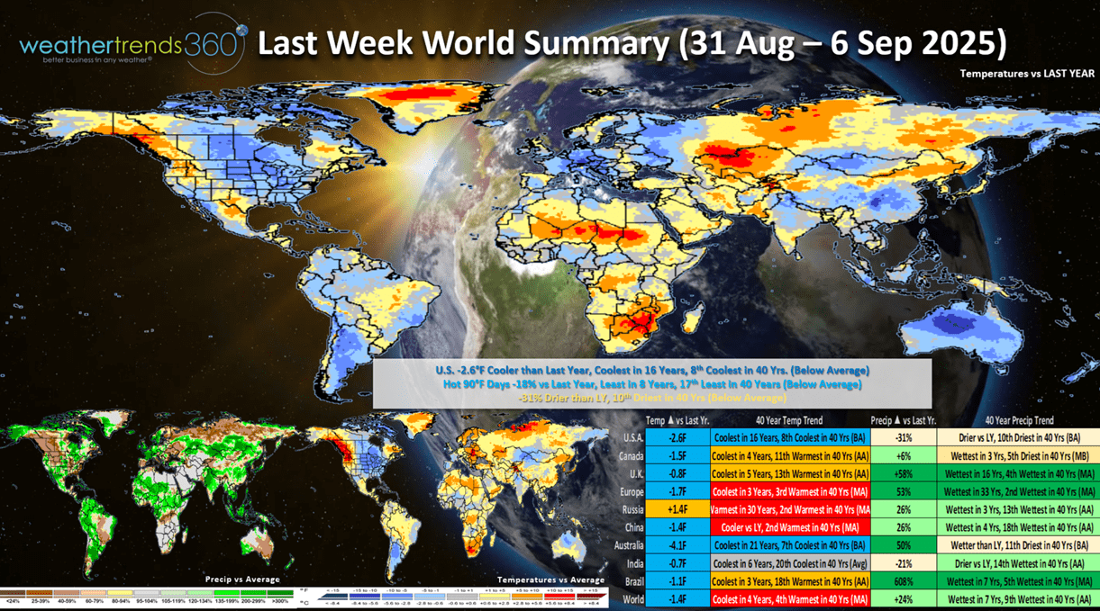
Last week (31 Aug - 6 Sep) - week before Labor Day was -2.6F cooler than LY in the U.S., coolest in 16 years and 8th coolest of the past 40 years. Hot 90F days down -18%, least in 8 years, while rainfall was down -31% vs LY. These are very favorable trends for Fall seasonal merchandise sales and store traffic.
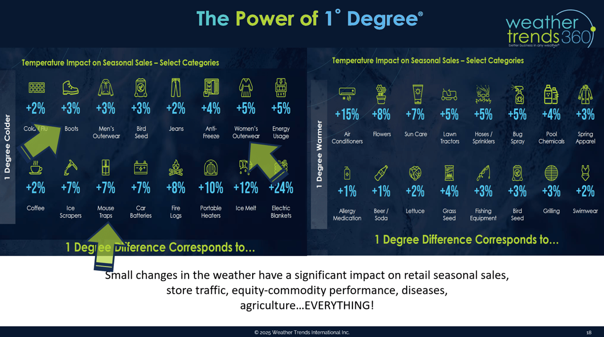
Our Power of 1 Degree technology quantifies this weather's influence on sales with every 1F cooler bringing a 3% bounce in boot sales, 5% in apparel sales and 7% in mouse trap sales - YUP - mice start to move into your sheds, garages, homes as it gets cooler.
Applying these metrics to the very cold North Central U.S. (coldest in over 40 years) and -6F cooler than LY would bring a +18% bounce in boot sales, +30% for apparel and +42% for mouse traps just due to much colder weather.

This week (7-13 Sep) shows the cooler weather hanging on in the East, but a warming trend in the North Central U.S. The U.S. overall still trends -0.8F cooler than a year ago, coolest in 5 years and 16th coolest in 40 years. Hot 90F days down -20% and least in 8 years, while rainfall is down -32% nationally and least in 20 years. Need to watch Florida late week for the potential for some tropical impacts.
Next week (14-20 Sep) is the last week of Summer and the weather cooperates with all but the Southeast showing above average temperatures. It's still -1.9F cooler nationally than a year ago but 8th warmest of the past 40 years. Hot 90F days down -47% and least in 5 years, with rainfall the 3rd least in 40 years. Still need to watch the tropics as conditions are favorable for something to develop quickly with a stalled cold front in the South.

The World 2-week Temperature outlook (7-20 Sep) shows a warming trend in the U.S. and Western Canada with cooler conditions in Central Europe.
The World 2-week Precipitation outlook (7-20 Sep) shows below average rainfall for the Eastern half of the U.S. which is good for farmers starting harvest. Dry in Western Europe, wet Eastern Europe. This time of year cooler and wetter weather is better for overall Fall seasonal merchandise sales.
Have a great week ahead, and don't forget to follow us on social media for frequent updates: Facebook, Twitter(X), YouTube, Pinterest and Linkedin.
- Captain Kirk out