Captain's Log 10 Apr '22 Volatile Weather Pattern!
Captain's Log
Happy Sunday! :)
A recap of last week 3-9 April across the World, shows the U.S. trending -7.1F colder than last year, coldest in 4 years and 14th coldest of the past 37 years with below average national temperatures. Rainfall was up +22% over last year, wettest in 3 years and 8th wettest of the past 37 years with above average national rainfall. Snowfall was +159% more than a year ago but still 8th least of the past 37 years and below average. CLICK ON IMAGES FOR A LARGER VIEW.
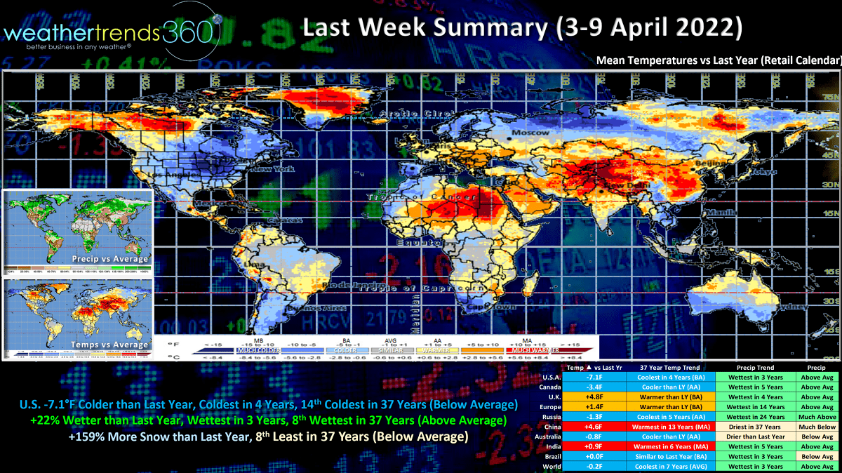
These cooler and wetter trends are generally unfavorable for Spring merchandise sales. The hot spots were in China where it was the warmest in 13 years and India warmest in 6 years.

Spring (1 March - 9 April) so far here in the U.S. has brought some wild up and down swings, but overall trending -2.6F colder than last year, coldest in 3 years but still 13th warmest of the past 37 years with above average national temperatures. Rainfall up +9%, wettest in 5 years and 13th wettest in 37 years with above average national rainfall. Very dry West, Wetter Midwest and East. A dry spot in the Ohio Valley. While snowfall is up +96% vs last year, most in 3 years, it's still 8th least in 37 years.
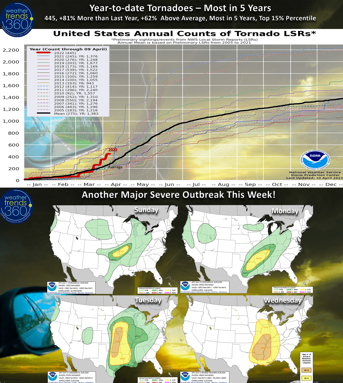
With the volatile up and down swings in temperatures with frequent strong cold fronts, tornadoes remain on a torrid pace with 445 reports so far. That's up +81% more than last year, +62% above average, most in 5 years and in the top 15% of active years. Another big outbreak likely this week as very cold air in the West clashes with very warm air in the East midweek. Texas to Illinois is the highest risk area with this outbreak.
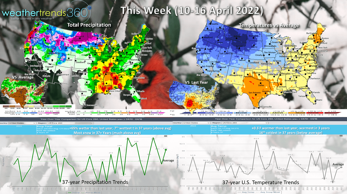
This week (10-16 April) is a tale of two halves with Winter in the West and almost Summer-like in the East through late week. For the U.S. overall temperatures trends +0.3F warmer than last year, warmest in 3 years but still 16th coldest of the past 37 years with below average national temperatures. This cold air will sweep East by the weekend. Rainfall is up +65% over last year and 7th wettest of the past 37 years, while snowfall will be the most in over 37 years for this middle April period.
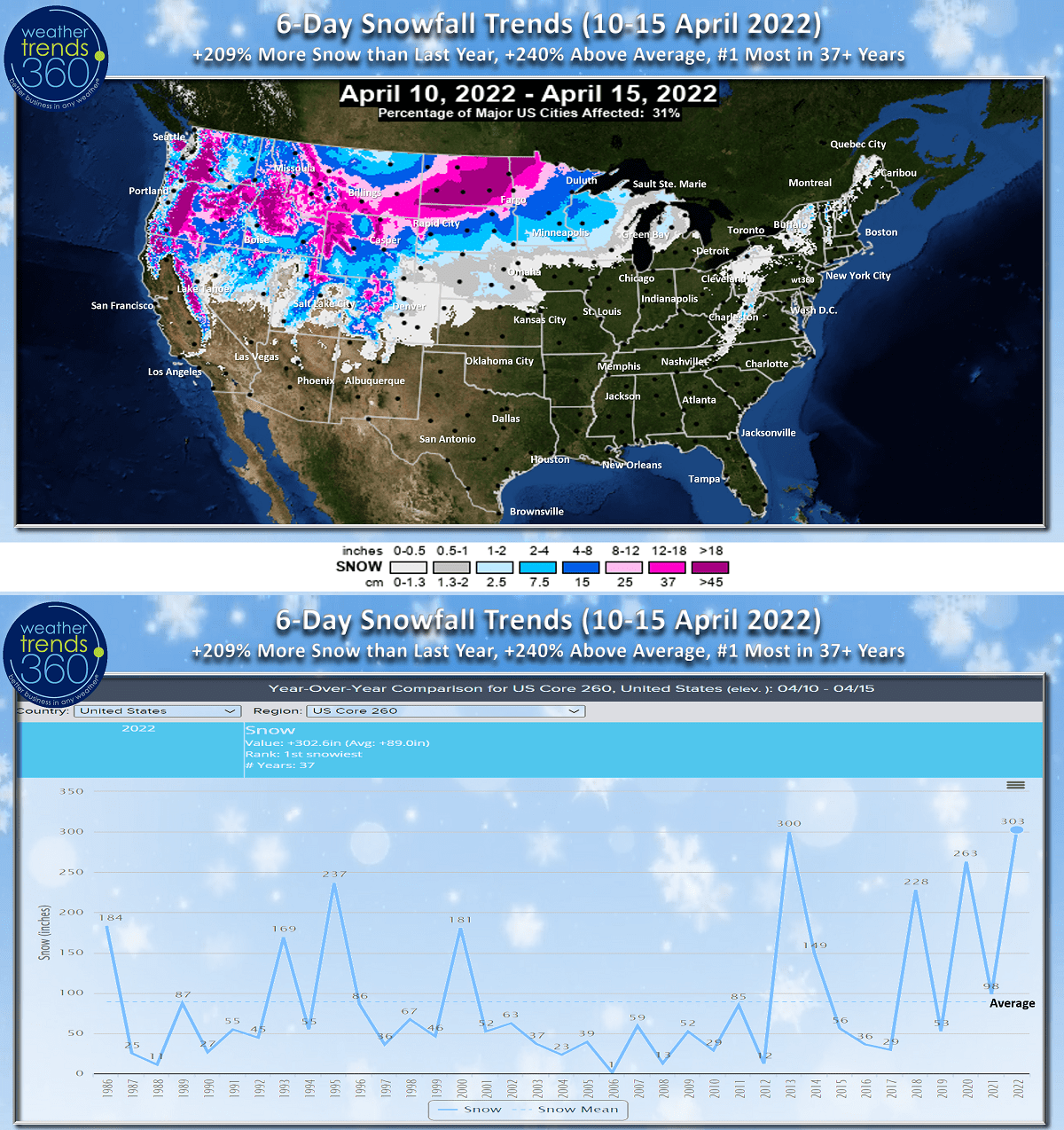
The 6-day snowfall trends show the exceptionally heavy snow in the higher elevations of the West, but even 12-18"+ moving into the Upper Plains and Upper Midwest making this the snowiest middle April period in over 37 years.
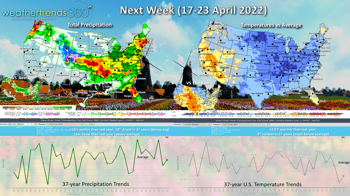
Next week (17-23 April) shows the West warming up while the lingering cold dominates the East with a gradual warming trend late in the week. The U.S. overall trends 2F warmer than last year but that's still 3rd coldest of the past 37 years. Rainfall up +16% over last year, but still 14th driest of the past 37 years. More severe weather possible in the Central U.S. and Florida. Snowfall down vs last year but still a bit above average with Eastern Rocky Mountain and Western Plains snowfall.
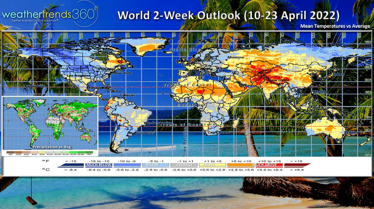
The 2-week World outlook (10-23 April) shows Florida and Texas as the warm spots, the rest of North America pretty cold. Western Europe is better than Eastern Europe and it remains hot from Northern Africa through the Middle East into China.
Have a great week, and don't forget to follow us on social media for frequent updates: Facebook, Twitter, YouTube, Pinterest and Linkedin.
- Captain Kirk out.