Captain's Log 10 Feb '24 Cooler, Much Wetter & Snowier Pattern
Captain's Log
10 Feb 2024: Happy Saturday :)
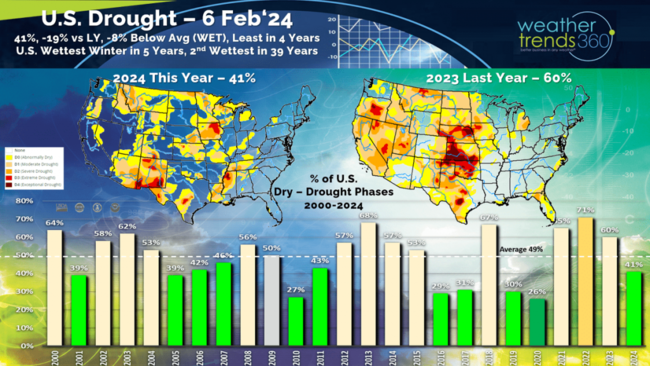
Drought continues to make rapid improvement with only 41% of the U.S. now in dry to drought phases, wettest in 4 years compared to 60% last year and 49% average. CLICK ON IMAGES FOR A LARGER VIEW.
While Iowa shows lingering drought, the Winter has been the wettest in 5 years and 5th wettest of the past 39. Next 2-weeks look even wetter trending 2nd wettest in 39 years for Iowa and much of the U.S.
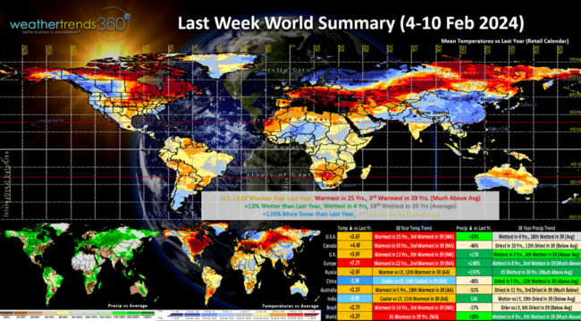
Last week (4-10 Feb) across the World shows the U.S. trending +2.6F warmer than last year, warmest in 25 years and 3rd warmest of the past 39 years. The West Coast was the best for Winter and storm merchandise with colder and much wetter conditions. Rainfall was up +13% nationally, wettest in 4 years and 18th wettest of the past 39 years. While snowfall was excessive in California, national snowfall was +129% more than a year ago but still 7th least of the past 39 years. Northern Europe and China were the cold spots.
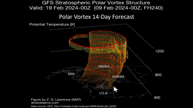
Polar Vortex models have varied on just how much the PV will split and weaken, but it is weakening and that allows for colder/snowier conditions to develop in the U.S. A stronger PV keeps the cold air bottled up at the North Pole.
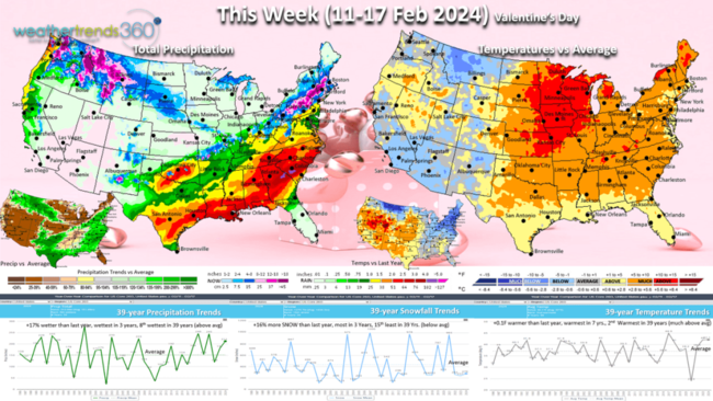
This week (11-17 Feb) Valentine's week shows a pre-Valentine's Day snowstorm for the interior Northeast from Ohio to Boston. The U.S. overall trends nearly similar to last year for temps, 2nd warmest in 39 years. Snowfall up +16% vs last year, most in 3 years but still 15th least of the past 39 years nationally. Rainfall is up +17% vs last year, most in 3 years and 8th wettest of the past 39 years. These are favorable trends for snow related merchandise, rain wear and snow accessories.
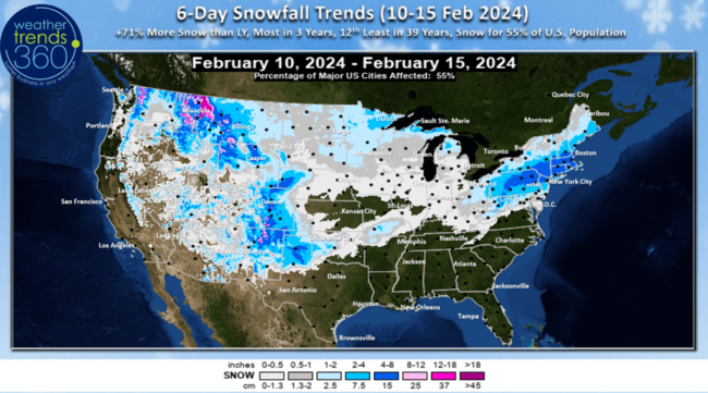
The 6-day snowfall outlook (10-15 Feb) shows the heavier snow in the Rocky Mountains and the Northeast storm. Recent models have been increasing the snow totals for the Tuesday Northeast event from Ohio to Maine with a moderate 4-8"+ event with some areas in the 10-12" range. The 6-day period trends +71% more than a year ago, most in 3 years, but still 12th least in 39 years but with 55% of the U.S. population getting some snow.
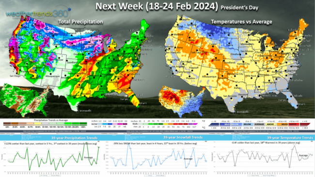
Next week (18-24 Feb) shows a stormy pattern across the U.S. with another big West Coast storm. Temperatures -0.4F cooler than a year ago, 18th warmest of the past 39 years. Rainfall up +123% vs last year, most in 5 years and 3rd wettest of the past 39 years while snowfall is -39% less than a year ago, least in 4 years and 15th least in 39 years. The snowfall is most likely underdone in light of the significant moisture available. This is another good week for storm and wet weather merchandise. The weeks ahead will start to have increasing severe thunderstorm and tornado threats with a very active severe weather season ahead.
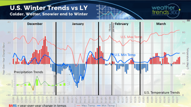
The U.S. Winter weather trends shows the much warmer December, Polar Vortex in January (coldest & snowiest MLK Jr week in 30 years) followed by a big warm up, and now a colder pattern into early-middle March to end Winter. The pattern does look stormy, so that increases the chances for bigger snowstorms.
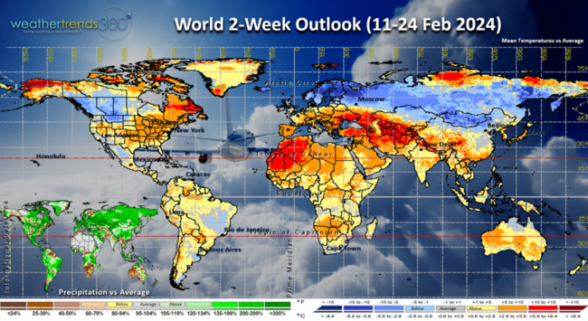
The World 2-week outlook (11-24 Feb) is a bit misleading as it's a few very warm days followed by more seasonable to cold days in the U.S. The heart of the really cold Arctic air is over Northern Europe, most of Russia and Western-Central Canada. Day time max temperatures in the U.S. won't be as warm as depicted here, but nighttime low temperatures will be above average with all the cloud cover and storms.
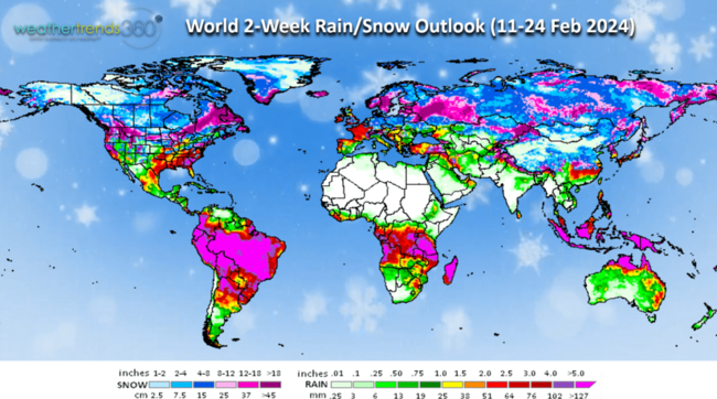
The World 2-week Precipitation outlook (11-24 Feb) shows the stormy U.S. pattern but also good news heavier rain across Brazil.
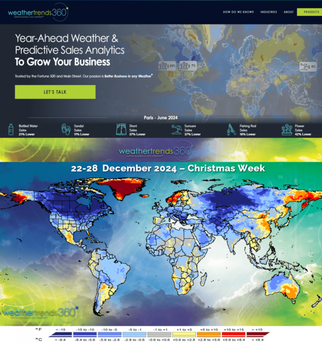
Twice a year we post one month of our year-ahead forecast on wt360.com which currently shows the more favorable June for retail sales. The next month you'll see is December which looks much more favorable for Winter merchandise as we transition to a moderate to strong La Niña event.
Have a great week ahead, and don't forget to follow us on social media for frequent updates: Facebook, Twitter, YouTube, Pinterest and Linkedin.
- Captain Kirk out
Drought continues to make rapid improvement with only 41% of the U.S. now in dry to drought phases, wettest in 4 years compared to 60% last year and 49% average. CLICK ON IMAGES FOR A LARGER VIEW.

While Iowa shows lingering drought, the Winter has been the wettest in 5 years and 5th wettest of the past 39. Next 2-weeks look even wetter trending 2nd wettest in 39 years for Iowa and much of the U.S.

Last week (4-10 Feb) across the World shows the U.S. trending +2.6F warmer than last year, warmest in 25 years and 3rd warmest of the past 39 years. The West Coast was the best for Winter and storm merchandise with colder and much wetter conditions. Rainfall was up +13% nationally, wettest in 4 years and 18th wettest of the past 39 years. While snowfall was excessive in California, national snowfall was +129% more than a year ago but still 7th least of the past 39 years. Northern Europe and China were the cold spots.

Polar Vortex models have varied on just how much the PV will split and weaken, but it is weakening and that allows for colder/snowier conditions to develop in the U.S. A stronger PV keeps the cold air bottled up at the North Pole.

This week (11-17 Feb) Valentine's week shows a pre-Valentine's Day snowstorm for the interior Northeast from Ohio to Boston. The U.S. overall trends nearly similar to last year for temps, 2nd warmest in 39 years. Snowfall up +16% vs last year, most in 3 years but still 15th least of the past 39 years nationally. Rainfall is up +17% vs last year, most in 3 years and 8th wettest of the past 39 years. These are favorable trends for snow related merchandise, rain wear and snow accessories.

The 6-day snowfall outlook (10-15 Feb) shows the heavier snow in the Rocky Mountains and the Northeast storm. Recent models have been increasing the snow totals for the Tuesday Northeast event from Ohio to Maine with a moderate 4-8"+ event with some areas in the 10-12" range. The 6-day period trends +71% more than a year ago, most in 3 years, but still 12th least in 39 years but with 55% of the U.S. population getting some snow.

Next week (18-24 Feb) shows a stormy pattern across the U.S. with another big West Coast storm. Temperatures -0.4F cooler than a year ago, 18th warmest of the past 39 years. Rainfall up +123% vs last year, most in 5 years and 3rd wettest of the past 39 years while snowfall is -39% less than a year ago, least in 4 years and 15th least in 39 years. The snowfall is most likely underdone in light of the significant moisture available. This is another good week for storm and wet weather merchandise. The weeks ahead will start to have increasing severe thunderstorm and tornado threats with a very active severe weather season ahead.

The U.S. Winter weather trends shows the much warmer December, Polar Vortex in January (coldest & snowiest MLK Jr week in 30 years) followed by a big warm up, and now a colder pattern into early-middle March to end Winter. The pattern does look stormy, so that increases the chances for bigger snowstorms.

The World 2-week outlook (11-24 Feb) is a bit misleading as it's a few very warm days followed by more seasonable to cold days in the U.S. The heart of the really cold Arctic air is over Northern Europe, most of Russia and Western-Central Canada. Day time max temperatures in the U.S. won't be as warm as depicted here, but nighttime low temperatures will be above average with all the cloud cover and storms.

The World 2-week Precipitation outlook (11-24 Feb) shows the stormy U.S. pattern but also good news heavier rain across Brazil.

Twice a year we post one month of our year-ahead forecast on wt360.com which currently shows the more favorable June for retail sales. The next month you'll see is December which looks much more favorable for Winter merchandise as we transition to a moderate to strong La Niña event.
Have a great week ahead, and don't forget to follow us on social media for frequent updates: Facebook, Twitter, YouTube, Pinterest and Linkedin.
- Captain Kirk out