Captain's Log 10 June '24 Keeping An Eye On the Tropics
Captain's Log
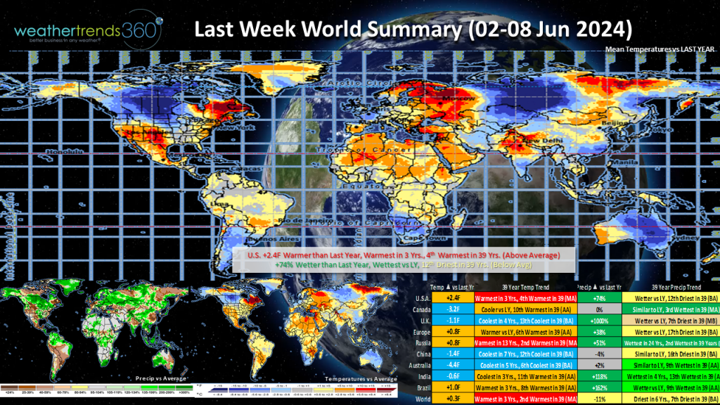
Last Week (2-8 June): Summer made itself known in the first full week of June 2024 which was the 4th warmest in 39 years for the U.S. as a whole.
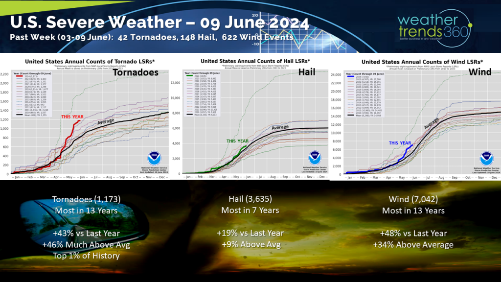
Severe weather activity continued although not nearly at the torrid pace of the previous weeks in May. However, the first week of June did feature a rare outbreak of tornadoes across Maryland, West Virgnia, and Virginia Wednesday. The National Weather Service in Baltimore/Washington D.C. confirmed 7 tornadoes touched down across the region. Luckily, the storms were all on the lower end of the Enhanced Fujita scale with EF-0 and EF-1 tornadoes confirmed. Overall, severe weather activity continues to run well above average for 2024.
The heat was on in the Desert Southwest and California Central Valley with triple digit heat making this one of the hottest starts to June in 39 years for the Southwest. Much of the rest of the nation trended warmer than normal.
Precipitation was greater than a very dry start to June last year but still slightly below normal. Wetter than normal trends could be found across the Midwest and down into northeast Texas, Oklahoma, Arkansas, and Louisiana. The Pacific Northwest also trended wetter than normal with an early week storm bringing strong winds and heavy rain; the latter half of the week turned drier.
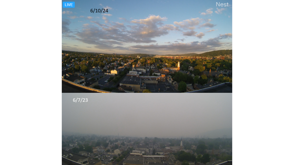
Speaking of last year, recall that this time last year a shroud of wildfire smoke from Canada blanketed a large portion of the East, including wt360 headquarters. Here's a comparison shot of this time last year compared to this year. Much brighter this year and we're thankful for that!
Last week (2-8 June) across the World, Canada continued to trend cooler compared to a very warm early June last year. Feeling cool in the United Kingdom where this was the coolest start to June in 4 years. Cooler trends could also be found across China and Australia.
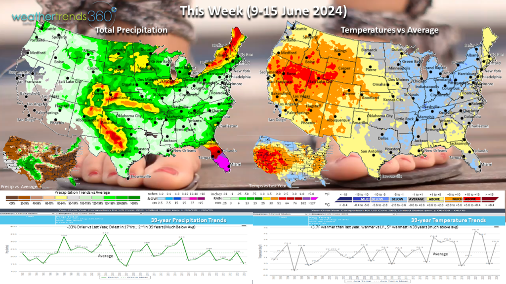
This Week (9-15 June): In the week ahead our focus will shift to the tropics as they start to show signs of life. It's going to be a soaker of a week for Florida where this is expected to be one of the wettest second weeks of June in 39 years. Tropical moisture will produce showers and thunderstorms for several days. We can't rule out the possibility of a tropical depression or storm developing later this week as the models have been wavering on that possibility over the past several days, but the biggest concern overall will be the threat for excessive rainfall and flooding.
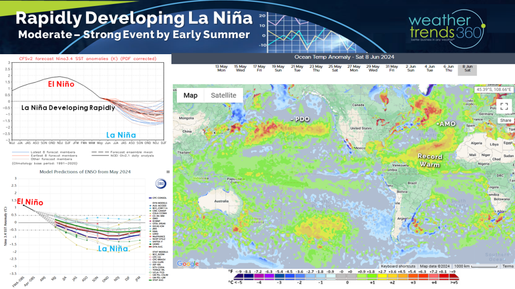
Wt360 expects a super-charged Atlantic Hurricane Season with a well above average number of storms. The season officially began on June 1st. La Nina continues to develop rapidly and combine that with record warm ocean temperatures in the tropical Atlantic and that makes for a very favorable environment for storm development and intensification.
For the U.S. as a whole, we'll be comparing to a cool second week of June last year while this year will trend warmer and above normal; this will be the 5th hottest second full week of June in 39 years. Hotter weather is expected to continue across the Southwest. The Northeast and North Central U.S. should see a rise in both heat and humidity in the latter half of the week following a rather delightful dry and somewhat cool, for this time year, start to the week.
Precipitation for the nation as a whole will trend drier than normal, but again, the Florida Peninsula will be the exception.
Next Week (16-22 June): The heat will continue to spread and become better established across the eastern half of the nation. For those of you currently enjoying the low humidity and pleasantly mild weather in the Northeast, don't expect this to last. Next week will bring a surge of heat and humidity so those ACs will be cranking.
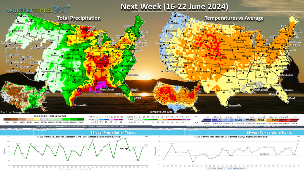
The other big weather story for next week will be the possibility of a tropical disturbance bringing heavy rain along the Gulf Coast. This will be something to keep an eye on over the next few days, but at this time the greatest risk looks to be excessive rainfall and flooding.
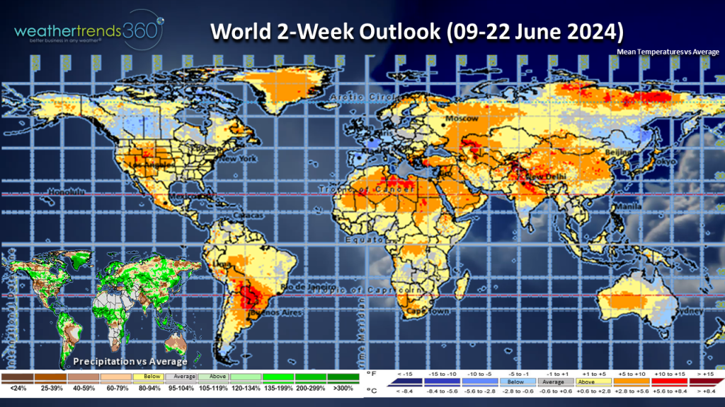
The World 2-week outlook (9-22 June): Wet across much of North America and heat will build across much of the U.S., Mexico, and eastern Canada. Trending cooler across Europe where the U.K. will continue to struggle with quite cool weather for this time of year, a big negative for summer categories. Elsewhere, we're warming in much of South America, Asia, and Africa.
Severe weather activity continued although not nearly at the torrid pace of the previous weeks in May. However, the first week of June did feature a rare outbreak of tornadoes across Maryland, West Virgnia, and Virginia Wednesday. The National Weather Service in Baltimore/Washington D.C. confirmed 7 tornadoes touched down across the region. Luckily, the storms were all on the lower end of the Enhanced Fujita scale with EF-0 and EF-1 tornadoes confirmed. Overall, severe weather activity continues to run well above average for 2024.
The heat was on in the Desert Southwest and California Central Valley with triple digit heat making this one of the hottest starts to June in 39 years for the Southwest. Much of the rest of the nation trended warmer than normal.
Precipitation was greater than a very dry start to June last year but still slightly below normal. Wetter than normal trends could be found across the Midwest and down into northeast Texas, Oklahoma, Arkansas, and Louisiana. The Pacific Northwest also trended wetter than normal with an early week storm bringing strong winds and heavy rain; the latter half of the week turned drier.
Speaking of last year, recall that this time last year a shroud of wildfire smoke from Canada blanketed a large portion of the East, including wt360 headquarters. Here's a comparison shot of this time last year compared to this year. Much brighter this year and we're thankful for that!
Last week (2-8 June) across the World, Canada continued to trend cooler compared to a very warm early June last year. Feeling cool in the United Kingdom where this was the coolest start to June in 4 years. Cooler trends could also be found across China and Australia.
This Week (9-15 June): In the week ahead our focus will shift to the tropics as they start to show signs of life. It's going to be a soaker of a week for Florida where this is expected to be one of the wettest second weeks of June in 39 years. Tropical moisture will produce showers and thunderstorms for several days. We can't rule out the possibility of a tropical depression or storm developing later this week as the models have been wavering on that possibility over the past several days, but the biggest concern overall will be the threat for excessive rainfall and flooding.
Wt360 expects a super-charged Atlantic Hurricane Season with a well above average number of storms. The season officially began on June 1st. La Nina continues to develop rapidly and combine that with record warm ocean temperatures in the tropical Atlantic and that makes for a very favorable environment for storm development and intensification.
For the U.S. as a whole, we'll be comparing to a cool second week of June last year while this year will trend warmer and above normal; this will be the 5th hottest second full week of June in 39 years. Hotter weather is expected to continue across the Southwest. The Northeast and North Central U.S. should see a rise in both heat and humidity in the latter half of the week following a rather delightful dry and somewhat cool, for this time year, start to the week.
Precipitation for the nation as a whole will trend drier than normal, but again, the Florida Peninsula will be the exception.
Next Week (16-22 June): The heat will continue to spread and become better established across the eastern half of the nation. For those of you currently enjoying the low humidity and pleasantly mild weather in the Northeast, don't expect this to last. Next week will bring a surge of heat and humidity so those ACs will be cranking.
The other big weather story for next week will be the possibility of a tropical disturbance bringing heavy rain along the Gulf Coast. This will be something to keep an eye on over the next few days, but at this time the greatest risk looks to be excessive rainfall and flooding.
The World 2-week outlook (9-22 June): Wet across much of North America and heat will build across much of the U.S., Mexico, and eastern Canada. Trending cooler across Europe where the U.K. will continue to struggle with quite cool weather for this time of year, a big negative for summer categories. Elsewhere, we're warming in much of South America, Asia, and Africa.