Captain's Log 14 Oct '23 Cooler Weather then Warming Trend
Captain's Log
It's Saturday 14 October '23. Can't say happy in light of world events.
We're halfway through meteorological Fall, so let's talk POLAR VORTEX and that 4-letter word SNOW! CLICK ON IMAGES FOR A LARGER VIEW.
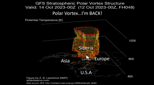
The Polar Vortex is developing over the North Pole as it does every Fall. The more symmetrical the PV is the more likely cold weather is bottled up at the North Pole, but when it wobbles with "vortices" spinning off that allows the Arctic air to invade the middle latitudes. For now, it's starting off relatively uniform and symmetrical, keeping the Northern Hemisphere on the warm side.
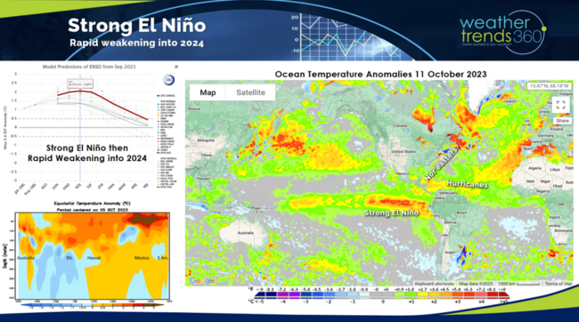
El Niño continues to strengthen but it's near a peak in the next month or so. From there it will likely weaken as we can already see cooler sub surface Pacific Ocean temperatures eroding the very warm eastern Equatorial Pacific. Weakening El Niño's, moderate El Niño's are historically snowy Winters in the U.S. and WT360 is projecting the snowiest U.S. Winter in 10 years with a Deep South ice storm track with Nor'easters up the East Coast. WT360 clients received an email PDF report summarizing our expectations month-by-month Thursday.
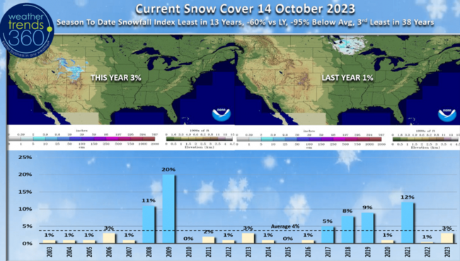
El Niño Falls are typically warm with the pattern shift toward late December. Snow Cover this morning was only 3% of the U.S. with snow on the ground, 4% is average.

WT360 clients are now getting our 14-day snowfall outlook report each morning via email; the 6-day outlook doesn't show much with the least snow in 7 years for the 14-29 October period. Look for this content in our blogs/videos in the weeks ahead.
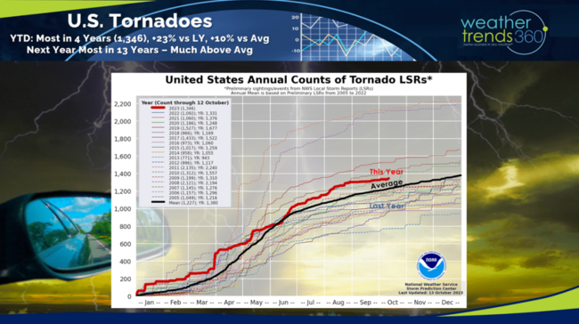
We added more tornadoes to the annual tally after an outbreak this week across Florida. YTD tornadoes stand at 1,346, +23% vs last year, +10% above average and the most in 4 years. WT360 expects the worst season in 13 years with a Deep South stormy pattern in Spring 2024.
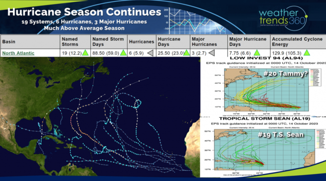
This much above average Hurricane season doesn't end until late November and there are still two tropical systems in the Eastern Atlantic - T.S. Sean (#19) and very likely T.S. Tammy (#20). Both heading toward the Eastern Caribbean, we'll see if Tammy's more southern track will make it to the U.S. in 10-14 days.
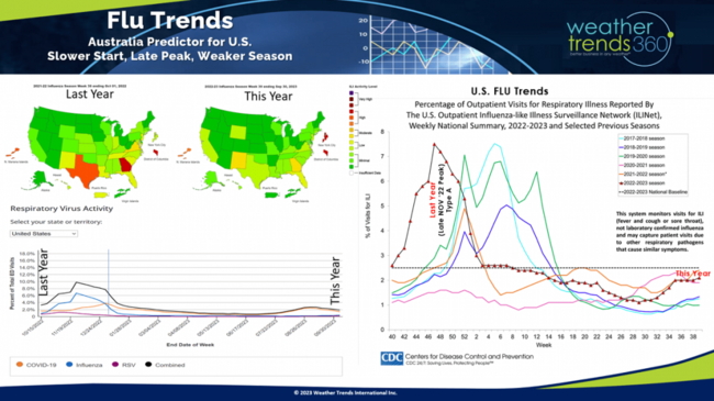
With the 3rd warmest Fall to date in the U.S., Flu is off to a slower start as expected. The peak this year is more likely to be in late Jan - early Feb as opposed to last year's very strong and early peak in late Nov.
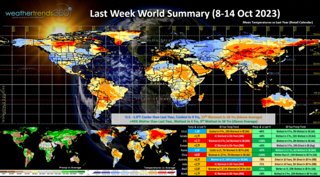
Last Week (8-14 Oct) around the World shows the U.S. trending -1.0F cooler than last year, coolest in 4 years but still 15th warmest of the past 38 years with above average national temperatures. Rainfall was up +46% vs last year, most in 4 years and 9th wettest of the past 38 years. Cooler and wetter are favorable trends for stronger retail store traffic and seasonal merchandise sales, so this was a bright spot in the otherwise very warm U.S. Fall. Canada was very warm and wet as was Europe. Australia is having the driest start to their Spring in 32 years - classic El Niño.
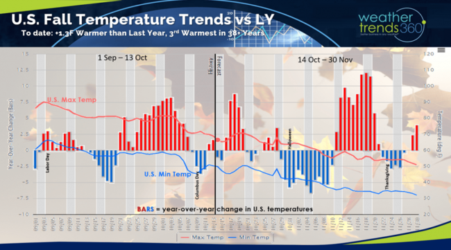
U.S. Fall (1 Sep - 30 Nov) year-over-year temperature trends show the U.S. +1.3F warmer than last year and 3rd warmest of the past 38 years. There have been a couple bright spots for seasonal sales in middle Sept, middle Oct and the best event in early November. Overall, a very challenging Fall for seasonal sales.

This week (15-21 Oct) shows a warming trend for the U.S. with temperatures trending +3.8F warmer than last year, warmest in 6 years and 9th warmest of the past 38 years. Other than Maine, most states are warmer to much warmer than a year ago, a negative for seasonal merchandise sales. Rainfall is up +34% vs last year, wettest in 3 years but still 11th driest of the past 38 years. More favorable dry weather in the Corn Belt for farmers harvesting.
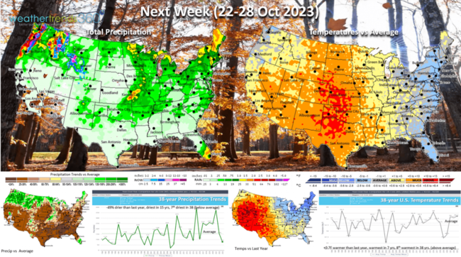
Next week (22-28 Oct) is the last week of the retail Q3 and it ends on a generally unfavorable note. National temperatures trend +0.7F warmer than last year, warmest in 7 years and 8th warmest of the past 38 years. The immediate East Coast is cooler than average and the Northeast quite a bit colder than a year ago, so that will be the bright spot for seasonal sales gains. Very hot for the Central U.S. Rainfall -49% drier than last year, driest in 15 years and 7th driest of the past 38 years.

The World 2-week outlook (15-28 Oct) shows the few bright spots for cooler weather limited to the Southeast U.S., Alaska, and Central-Northern Europe.
Have a great week ahead, and don't forget to follow us on social media for frequent updates: Facebook, Twitter, YouTube, Pinterest and Linkedin.
- Captain Kirk out
We're halfway through meteorological Fall, so let's talk POLAR VORTEX and that 4-letter word SNOW! CLICK ON IMAGES FOR A LARGER VIEW.

The Polar Vortex is developing over the North Pole as it does every Fall. The more symmetrical the PV is the more likely cold weather is bottled up at the North Pole, but when it wobbles with "vortices" spinning off that allows the Arctic air to invade the middle latitudes. For now, it's starting off relatively uniform and symmetrical, keeping the Northern Hemisphere on the warm side.
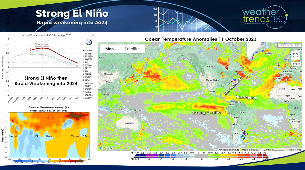
El Niño continues to strengthen but it's near a peak in the next month or so. From there it will likely weaken as we can already see cooler sub surface Pacific Ocean temperatures eroding the very warm eastern Equatorial Pacific. Weakening El Niño's, moderate El Niño's are historically snowy Winters in the U.S. and WT360 is projecting the snowiest U.S. Winter in 10 years with a Deep South ice storm track with Nor'easters up the East Coast. WT360 clients received an email PDF report summarizing our expectations month-by-month Thursday.

El Niño Falls are typically warm with the pattern shift toward late December. Snow Cover this morning was only 3% of the U.S. with snow on the ground, 4% is average.
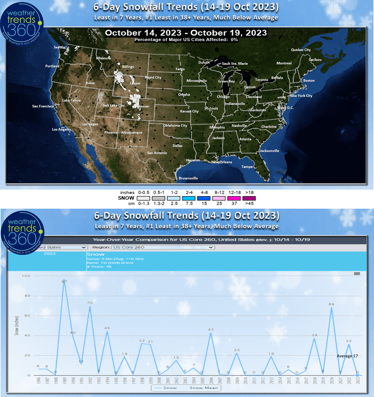
WT360 clients are now getting our 14-day snowfall outlook report each morning via email; the 6-day outlook doesn't show much with the least snow in 7 years for the 14-29 October period. Look for this content in our blogs/videos in the weeks ahead.
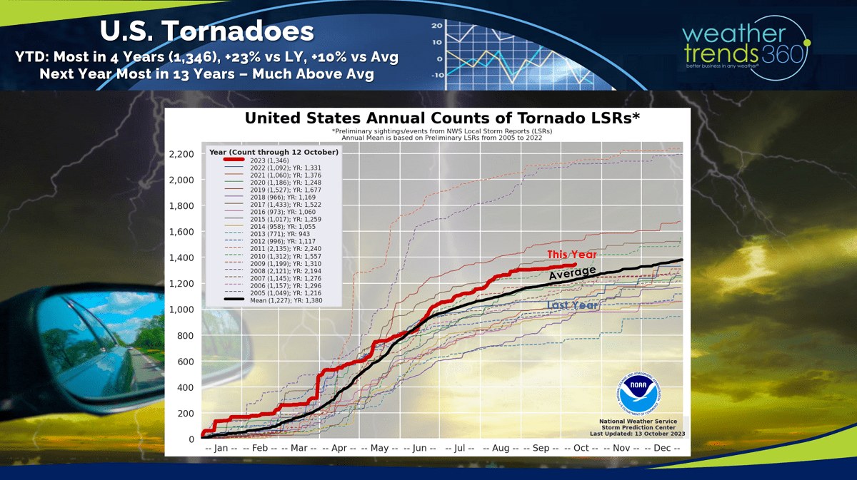
We added more tornadoes to the annual tally after an outbreak this week across Florida. YTD tornadoes stand at 1,346, +23% vs last year, +10% above average and the most in 4 years. WT360 expects the worst season in 13 years with a Deep South stormy pattern in Spring 2024.
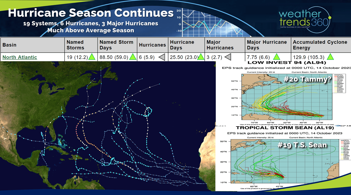
This much above average Hurricane season doesn't end until late November and there are still two tropical systems in the Eastern Atlantic - T.S. Sean (#19) and very likely T.S. Tammy (#20). Both heading toward the Eastern Caribbean, we'll see if Tammy's more southern track will make it to the U.S. in 10-14 days.
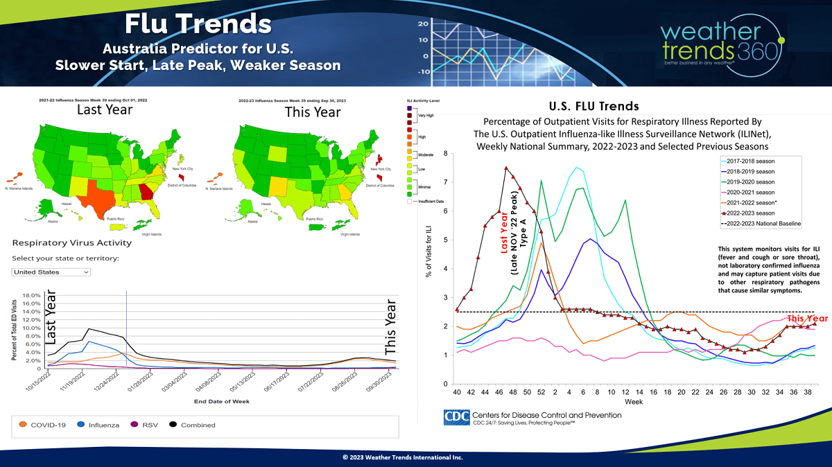
With the 3rd warmest Fall to date in the U.S., Flu is off to a slower start as expected. The peak this year is more likely to be in late Jan - early Feb as opposed to last year's very strong and early peak in late Nov.
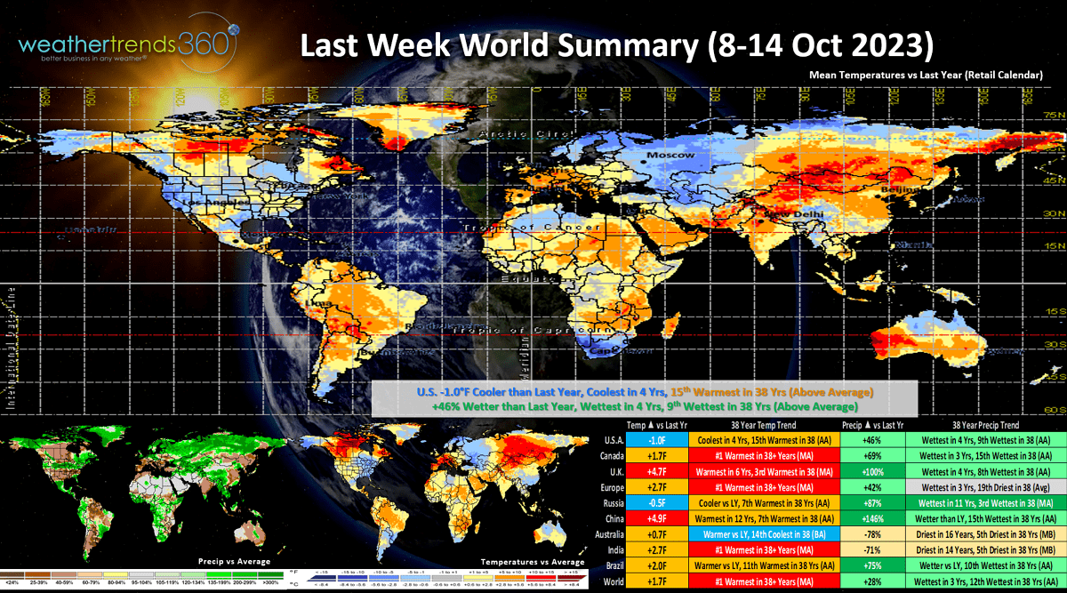
Last Week (8-14 Oct) around the World shows the U.S. trending -1.0F cooler than last year, coolest in 4 years but still 15th warmest of the past 38 years with above average national temperatures. Rainfall was up +46% vs last year, most in 4 years and 9th wettest of the past 38 years. Cooler and wetter are favorable trends for stronger retail store traffic and seasonal merchandise sales, so this was a bright spot in the otherwise very warm U.S. Fall. Canada was very warm and wet as was Europe. Australia is having the driest start to their Spring in 32 years - classic El Niño.
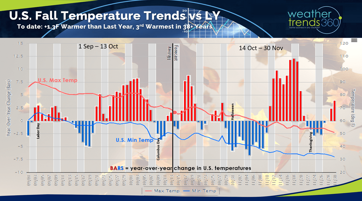
U.S. Fall (1 Sep - 30 Nov) year-over-year temperature trends show the U.S. +1.3F warmer than last year and 3rd warmest of the past 38 years. There have been a couple bright spots for seasonal sales in middle Sept, middle Oct and the best event in early November. Overall, a very challenging Fall for seasonal sales.
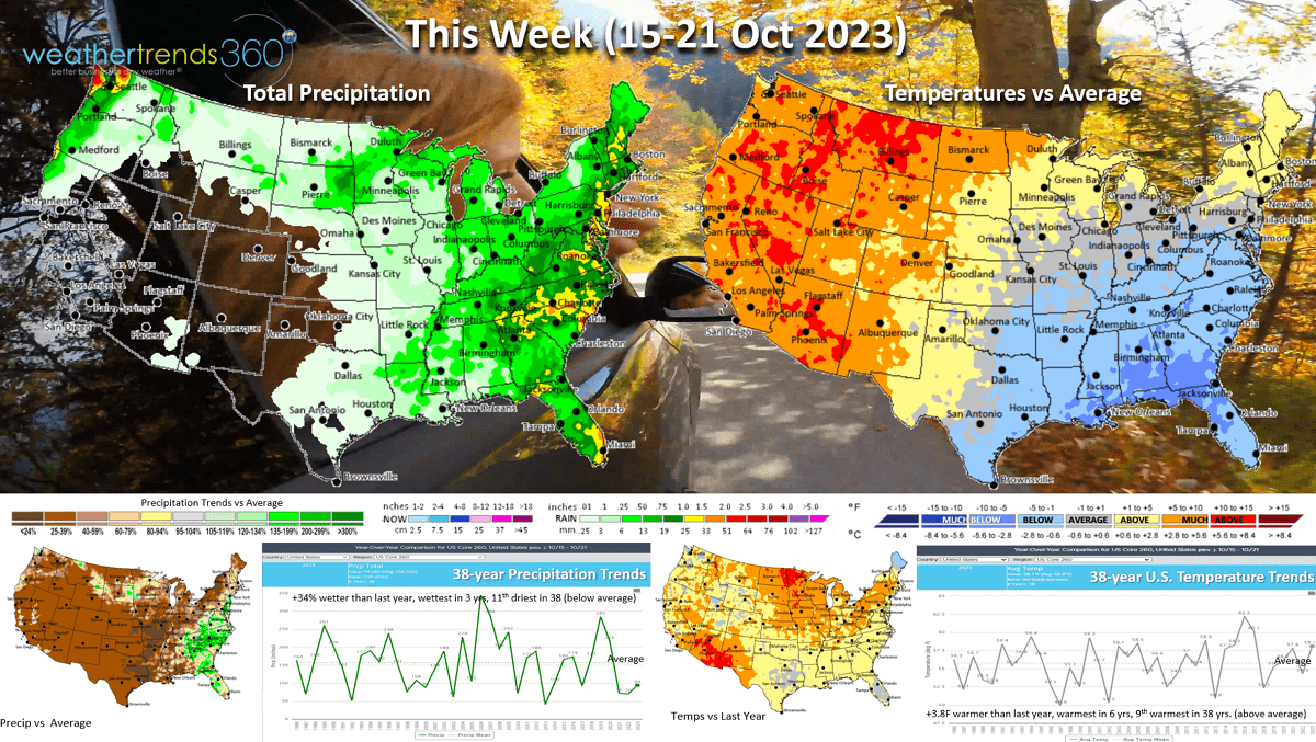
This week (15-21 Oct) shows a warming trend for the U.S. with temperatures trending +3.8F warmer than last year, warmest in 6 years and 9th warmest of the past 38 years. Other than Maine, most states are warmer to much warmer than a year ago, a negative for seasonal merchandise sales. Rainfall is up +34% vs last year, wettest in 3 years but still 11th driest of the past 38 years. More favorable dry weather in the Corn Belt for farmers harvesting.
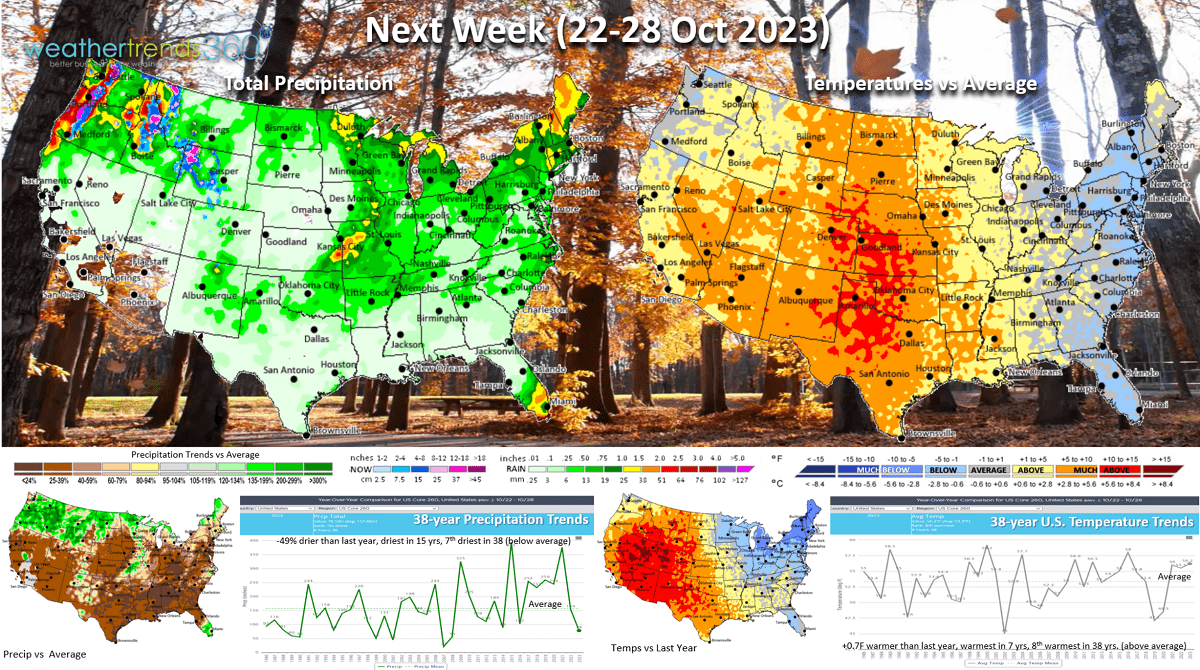
Next week (22-28 Oct) is the last week of the retail Q3 and it ends on a generally unfavorable note. National temperatures trend +0.7F warmer than last year, warmest in 7 years and 8th warmest of the past 38 years. The immediate East Coast is cooler than average and the Northeast quite a bit colder than a year ago, so that will be the bright spot for seasonal sales gains. Very hot for the Central U.S. Rainfall -49% drier than last year, driest in 15 years and 7th driest of the past 38 years.

The World 2-week outlook (15-28 Oct) shows the few bright spots for cooler weather limited to the Southeast U.S., Alaska, and Central-Northern Europe.
Have a great week ahead, and don't forget to follow us on social media for frequent updates: Facebook, Twitter, YouTube, Pinterest and Linkedin.
- Captain Kirk out