Captain's Log 14 Sep '24 Tropical Threats and Warmer Pattern
Captain's Log
14 Sep '24: Happy Saturday! :)
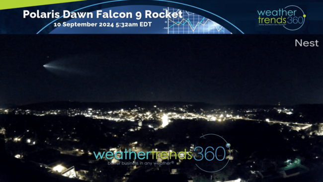
wt360 Weather Camera South overlooking Bethlehem, PA and Lehigh University, captured the Polaris Dawn Falcon 9 rocket streaming by on its historic mission (video). Commander Jared Isaacman is a Lehigh Valley native and CEO of Shift4 Payments here in the valley. CLICK ON IMAGES FOR A LARGER VIEW.
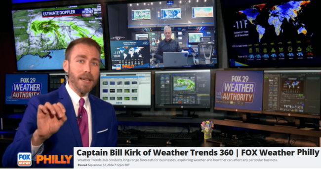
We've had a barrage of press lately and this past week we were on FOX29 Philadelphia talking everything business and consumer weather. Long segment but enjoy the show.
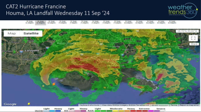
The hurricane season has come to life as climate cycles become more favorable after the lull in late Aug - early September. CAT2 Francine made landfall in the Houma to New Orleans Louisiana areas with flooding the biggest impact. This is the 3rd U.S. landfalling hurricane this season and we're not done yet!
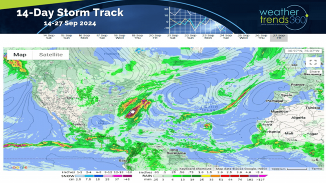
We still have 77 days left in the 2024 season which shows several tropical threats over the next couple weeks to include the Carolinas and South Florida. NOAA is monitoring a system of the Carolina coast that could become the 8th named storm (#8 Helene).
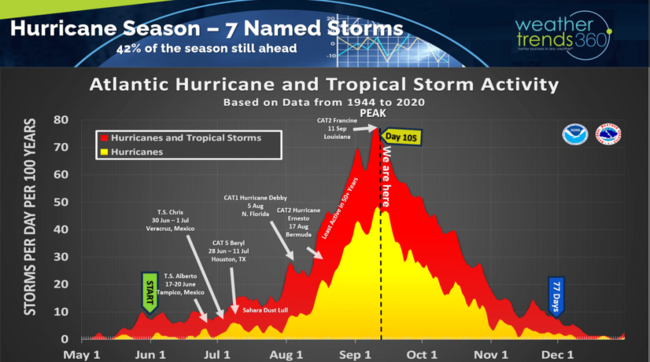
wt360's season ahead hurricane outlook identified several high-risk areas for more significant damage for TX-LA, S FL and the Carolinas. That's exactly where the 3 U.S. landfalling systems have occurred with more likely in the months ahead. Even Bermuda was flagged as moderate risk and CAT2 Ernesto made a direct hit.
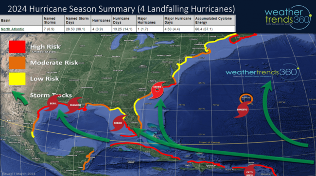
We're still expecting a major landfalling hurricane over the next couple months and models hint at a threat to Florida late September (TBD).
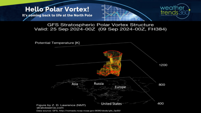
The North Pole Polar Vortex continues to show signs of life, and it will play a big role this Winter. Expectations are for a weaker vortex which will allow more frequent cold snaps across Canada and the U.S.
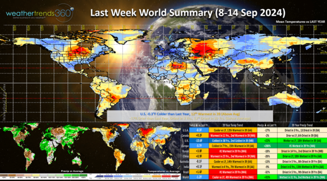
Last Week (8-14 Sep) across the World shows the U.S. trending -0.3F colder for the second week in a row but 12th warmest of the past 39 years. The East Coast and Southeast were the favorable spots for early Fall seasonal merchandise sales. Rainfall was down -17% vs last year, driest in 3 years and 13th driest of the past 39. The U.K. had exceptional weather for seasonal merchandise with the coldest conditions in 38 years! Russia, China and Brazil were all in the top 2 hottest in 40 years.
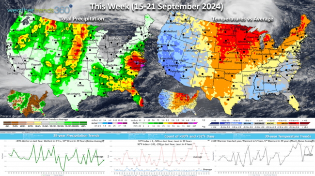
This week (15-21 Sep) shows the U.S. trending +3F warmer than last year, warmest in 5 years and 5th warmest of the past 39 years. Hot 90F days and cold 32F days are both down vs last year. Rainfall is +19% wetter, wettest in 3 years but 13th driest in 39 years. Need to watch for a tropical storm impacting the Carolinas with more flooding rains in the same general area as T.S. Debbie. Amazing how they went from drought early in the Summer to floods late. The West Coast gets a big cool down and most favorable for early Fall merchandise.
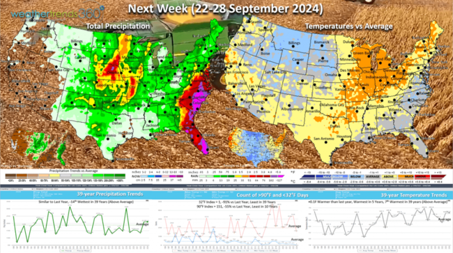
Next week (22-28 Sep) shows the transitory pattern with the cool weather moving into the Plains while the West Coast warms up. Need to watch the tropics, especially Florida as systems can develop very quickly with little advance warning. Models are hinting at a tropical threat from Florida to the East Coast late in the period (TBD). Overall the U.S. trends very similar to last year for both temperatures and rainfall while hot 90F and cold 32F days are both down vs last year. The Upper Plains are the most favorable for Fall merchandise, the Southeast most favorable for storm merchandise. Farmers are in the heart of harvest season with some rain to content with across the Corn Belt.
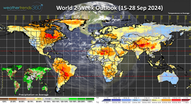
The World 2-week outlook (15-28 Sep) shows overall unfavorable conditions for Fall merchandise across North America and a big warming trend across Europe.
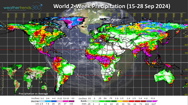
World rainfall and snowfall trends continue to show very wet conditions over tropical Africa suggesting there will be plenty of tropical waves moving out into the Atlantic for the core of the Cape Verde season.
Have a great week ahead, and don't forget to follow us on social media for frequent updates: Facebook, Twitter, YouTube, Pinterest and Linkedin.
- Captain Kirk out.
wt360 Weather Camera South overlooking Bethlehem, PA and Lehigh University, captured the Polaris Dawn Falcon 9 rocket streaming by on its historic mission (video). Commander Jared Isaacman is a Lehigh Valley native and CEO of Shift4 Payments here in the valley. CLICK ON IMAGES FOR A LARGER VIEW.

We've had a barrage of press lately and this past week we were on FOX29 Philadelphia talking everything business and consumer weather. Long segment but enjoy the show.

The hurricane season has come to life as climate cycles become more favorable after the lull in late Aug - early September. CAT2 Francine made landfall in the Houma to New Orleans Louisiana areas with flooding the biggest impact. This is the 3rd U.S. landfalling hurricane this season and we're not done yet!

We still have 77 days left in the 2024 season which shows several tropical threats over the next couple weeks to include the Carolinas and South Florida. NOAA is monitoring a system of the Carolina coast that could become the 8th named storm (#8 Helene).

wt360's season ahead hurricane outlook identified several high-risk areas for more significant damage for TX-LA, S FL and the Carolinas. That's exactly where the 3 U.S. landfalling systems have occurred with more likely in the months ahead. Even Bermuda was flagged as moderate risk and CAT2 Ernesto made a direct hit.

We're still expecting a major landfalling hurricane over the next couple months and models hint at a threat to Florida late September (TBD).

The North Pole Polar Vortex continues to show signs of life, and it will play a big role this Winter. Expectations are for a weaker vortex which will allow more frequent cold snaps across Canada and the U.S.

Last Week (8-14 Sep) across the World shows the U.S. trending -0.3F colder for the second week in a row but 12th warmest of the past 39 years. The East Coast and Southeast were the favorable spots for early Fall seasonal merchandise sales. Rainfall was down -17% vs last year, driest in 3 years and 13th driest of the past 39. The U.K. had exceptional weather for seasonal merchandise with the coldest conditions in 38 years! Russia, China and Brazil were all in the top 2 hottest in 40 years.

This week (15-21 Sep) shows the U.S. trending +3F warmer than last year, warmest in 5 years and 5th warmest of the past 39 years. Hot 90F days and cold 32F days are both down vs last year. Rainfall is +19% wetter, wettest in 3 years but 13th driest in 39 years. Need to watch for a tropical storm impacting the Carolinas with more flooding rains in the same general area as T.S. Debbie. Amazing how they went from drought early in the Summer to floods late. The West Coast gets a big cool down and most favorable for early Fall merchandise.

Next week (22-28 Sep) shows the transitory pattern with the cool weather moving into the Plains while the West Coast warms up. Need to watch the tropics, especially Florida as systems can develop very quickly with little advance warning. Models are hinting at a tropical threat from Florida to the East Coast late in the period (TBD). Overall the U.S. trends very similar to last year for both temperatures and rainfall while hot 90F and cold 32F days are both down vs last year. The Upper Plains are the most favorable for Fall merchandise, the Southeast most favorable for storm merchandise. Farmers are in the heart of harvest season with some rain to content with across the Corn Belt.

The World 2-week outlook (15-28 Sep) shows overall unfavorable conditions for Fall merchandise across North America and a big warming trend across Europe.

World rainfall and snowfall trends continue to show very wet conditions over tropical Africa suggesting there will be plenty of tropical waves moving out into the Atlantic for the core of the Cape Verde season.

Have a great week ahead, and don't forget to follow us on social media for frequent updates: Facebook, Twitter, YouTube, Pinterest and Linkedin.
- Captain Kirk out.