Captain's Log 17 Feb '24 Warmer/Stormier Pattern
Captain's Log
17 Feb '24: Happy Saturday :)

If you're counting down, 30 days left of Winter or 30 days until Spring. CLICK ON IMAGES FOR A LARGER VIEW.

Even the weather guys were surprised by an intense narrow band of heavy snow overnight near wt360 HQ in Bethlehem PA. Expecting 2-6" with an Alberta Clipper storm that traversed the entire U.S., but then a narrow band of 11-14" of heavy snow setups from Reading PA to New Brunswick NJ. And all of that came in about 6 hours overnight.

It was the second snowstorm this week bringing almost 24" to areas near wt360 HQ in the Lehigh Valley PA. The Clipper storm moved across the entire U.S. in just a couple days with pockets of heavier snow not all that common with Clipper storms.
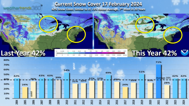
Snow Cover this morning has 42% of the U.S. blanketed in some snow which is similar to last year and 3% above average for this date.
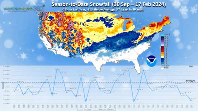
Season to date (30 Sep - 17 Feb) snowfall is still way down after the very slow start with the U.S. down -16% vs last year, -31% below average and 3rd least in 39 years.

But it's a tale of two halves as 2024 has been quite a bit snowier than the front half of Winter. Comparing this Winter with last Winter it's a very different pattern with last year much snowier the front half, nothing in the middle and then a snowier Spring. This Winter little for the front half but now a snowier back half with 4 snowier weeks so far.

The 1 Jan - 17 Feb 2024 period is now trending the snowiest in 3 years nationally and near average. The big winners for more snowfall are in the East, South Central and Pacific Northwest.
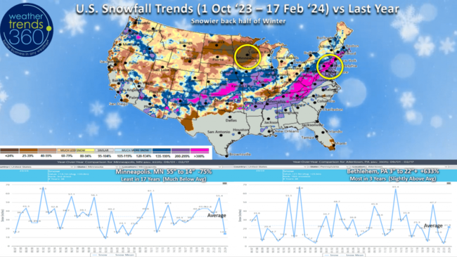
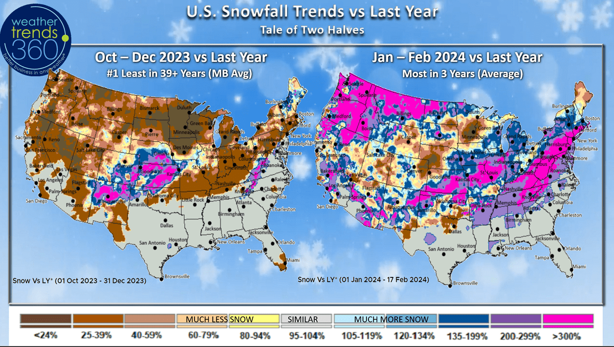
The season to date snowfall trends vs last year show the much snowier areas vs a year ago are from Kansas to Illinois and the Appalachians up into the Coastal Northeast. Minneapolis MN snowfall as an example is down -75% vs last year, least in 17 years, while here at wt360 HQ in the Lehigh Valley we're up +633% over last year, most in 3 years and that will go higher after today's storm is factored in.
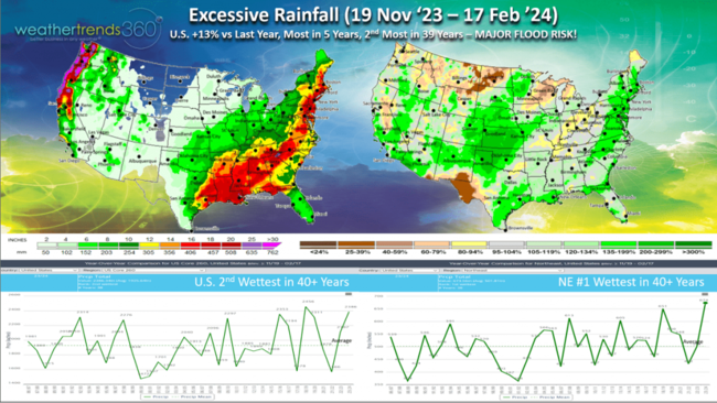
Since middle November, the El Niño cycle certainly brought a lot of storms with rainfall the most in 5 years and 2nd most in 39+ years for the U.S. overall. The Northeast is even wetter trending #1 wettest in over 39 years. This suggests a big flood concern this Spring with the ground already saturated.
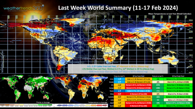
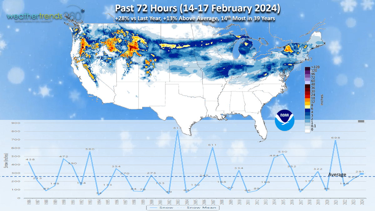
Last week (11-17 Feb '24) across the World shows the U.S. trending -1.2F colder than last year, 8th warmest of the past 39 years. Rainfall up +1%, wettest in 3 years and 12th wettest of the past 39, while snowfall was up +69% vs last year and 19th most of the past 39 years. Russia was the cold spot while China was the hot spot.
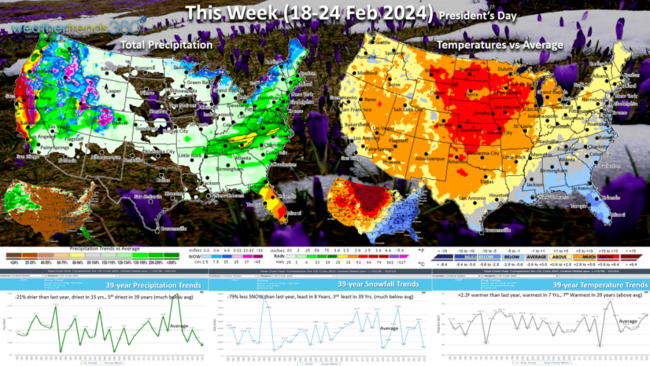
This week (18-24 Feb) shows a moderating trend with a big warm up in the Central U.S. U.S. temperatures trend +2.2F warmer than last year, warmest in 7 years and 7th warmest of the past 39 years. The East trends much cooler than last year. Rainfall -21% vs a year ago, driest in 15 years and 5th driest of the past 39, while snowfall is down -79%, least in 8 years and 3rd least in 39 years. TBD as models are not handling snow events well even a few days out. Still some risk for another snow event next weekend in the East.

Next week (25 Feb - 2 Mar) A stormy week with rainfall up +36% vs last year, wettest in 6 years and 6th wettest in 39 years, while snowfall is -28% less than a year ago and 20th least of the past 39. Temperatures are +3.1F warmer than last year making it the warmest in 24years and 2nd warmest in 39 years. But signs of colder weather returning for the early to middle March period.
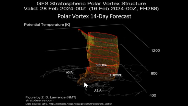
The Polar Vortex does look to wobble again with the brutally cold air currently in Central Siberia advancing to Northeast Siberia and Alaska with some of this slowly moving back into the U.S. by early March.
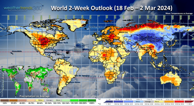
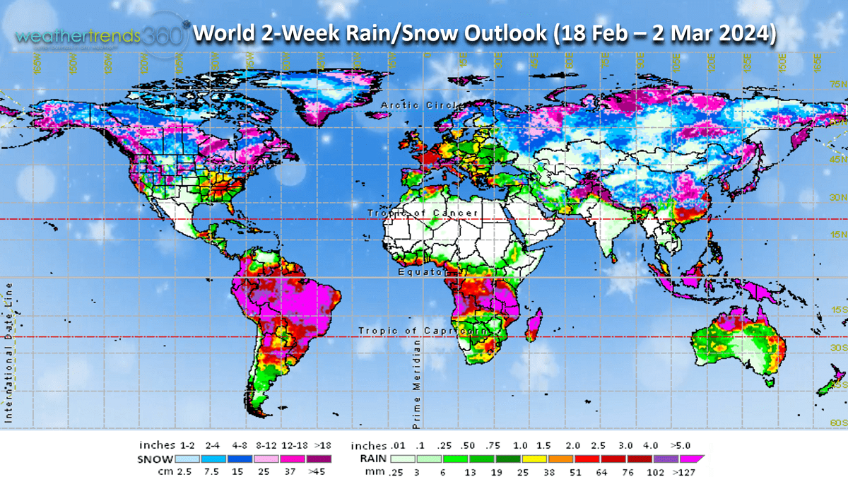
The World 2-week outlook (18 Feb -2 Mar) shows the PV moving toward China and Alaska keeping it very warm in Europe, the U.S. and Canada.
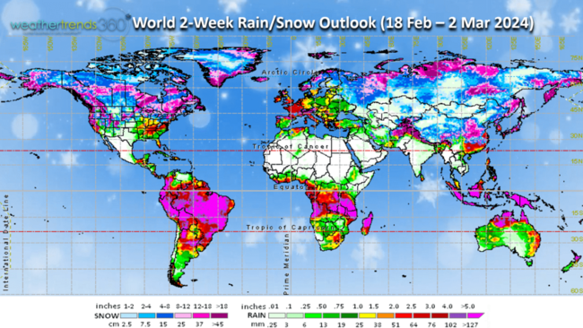
The pattern does look stormy for many areas, so the threats for bigger snowstorms are not over.
We end today's video with a time-lapse of the heavy snowstorm as it traversed through Eastern PA last night. Have a great week ahead and don't forget to follow us on social media for frequent updates: Facebook, Twitter, YouTube, Pinterest and Linkedin.
- Captain Kirk out
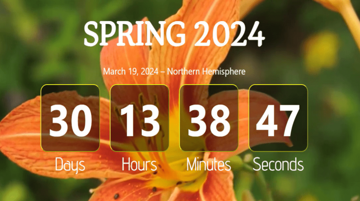
If you're counting down, 30 days left of Winter or 30 days until Spring. CLICK ON IMAGES FOR A LARGER VIEW.
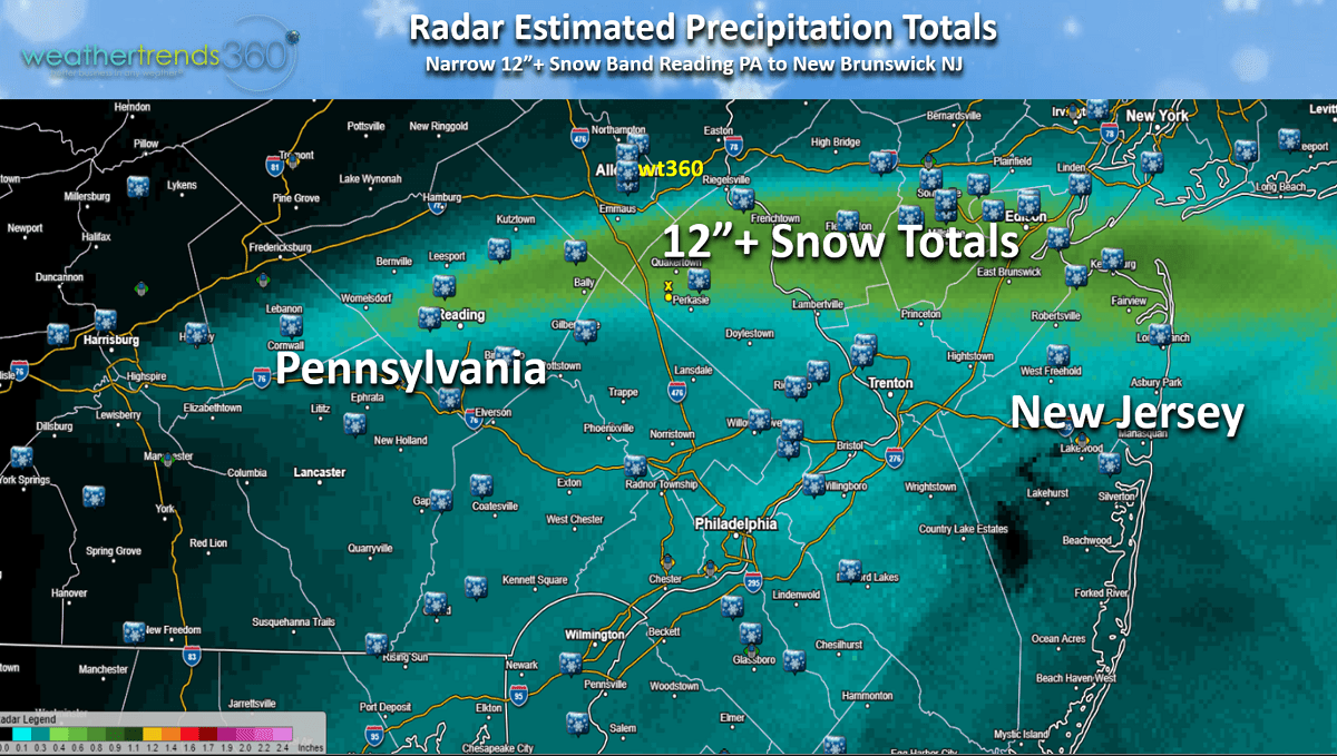
Even the weather guys were surprised by an intense narrow band of heavy snow overnight near wt360 HQ in Bethlehem PA. Expecting 2-6" with an Alberta Clipper storm that traversed the entire U.S., but then a narrow band of 11-14" of heavy snow setups from Reading PA to New Brunswick NJ. And all of that came in about 6 hours overnight.
It was the second snowstorm this week bringing almost 24" to areas near wt360 HQ in the Lehigh Valley PA. The Clipper storm moved across the entire U.S. in just a couple days with pockets of heavier snow not all that common with Clipper storms.
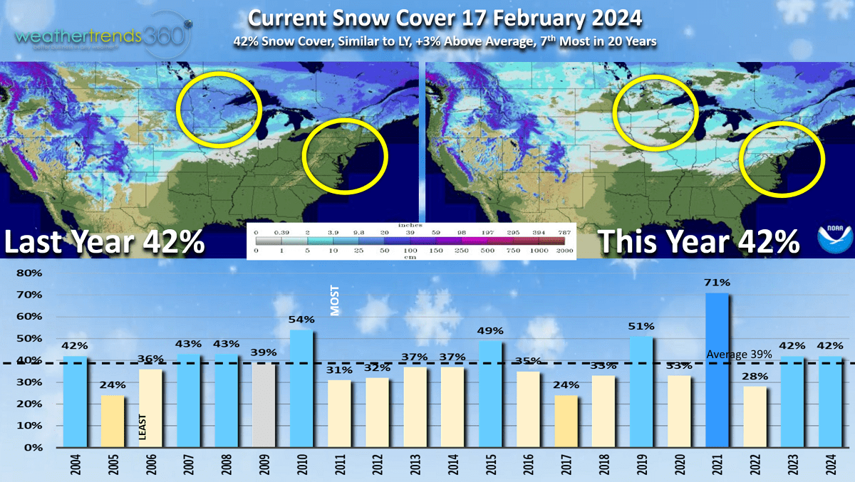
Snow Cover this morning has 42% of the U.S. blanketed in some snow which is similar to last year and 3% above average for this date.
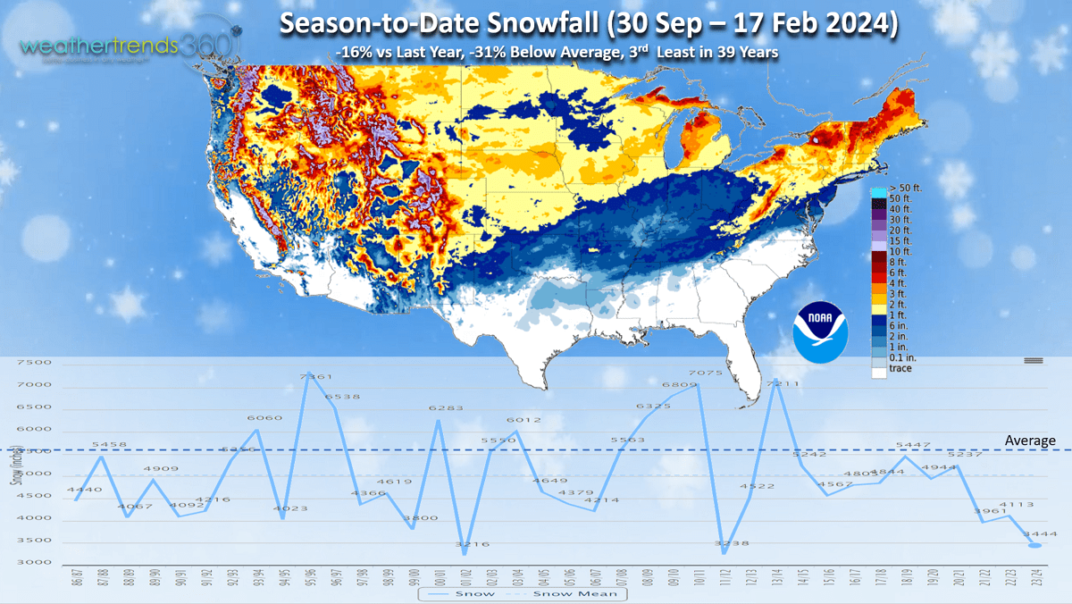
Season to date (30 Sep - 17 Feb) snowfall is still way down after the very slow start with the U.S. down -16% vs last year, -31% below average and 3rd least in 39 years.
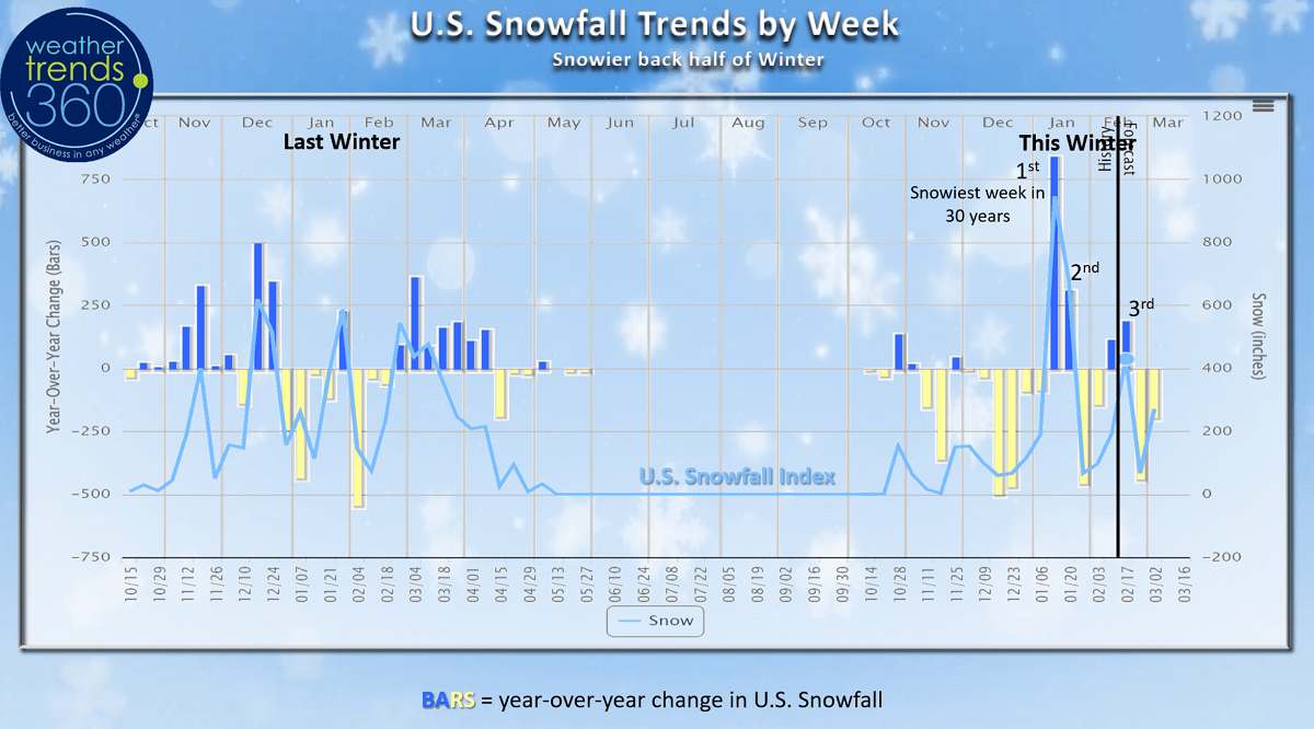
But it's a tale of two halves as 2024 has been quite a bit snowier than the front half of Winter. Comparing this Winter with last Winter it's a very different pattern with last year much snowier the front half, nothing in the middle and then a snowier Spring. This Winter little for the front half but now a snowier back half with 4 snowier weeks so far.
The 1 Jan - 17 Feb 2024 period is now trending the snowiest in 3 years nationally and near average. The big winners for more snowfall are in the East, South Central and Pacific Northwest.

The season to date snowfall trends vs last year show the much snowier areas vs a year ago are from Kansas to Illinois and the Appalachians up into the Coastal Northeast. Minneapolis MN snowfall as an example is down -75% vs last year, least in 17 years, while here at wt360 HQ in the Lehigh Valley we're up +633% over last year, most in 3 years and that will go higher after today's storm is factored in.
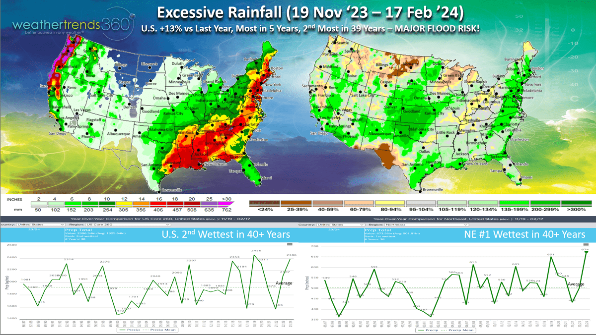
Since middle November, the El Niño cycle certainly brought a lot of storms with rainfall the most in 5 years and 2nd most in 39+ years for the U.S. overall. The Northeast is even wetter trending #1 wettest in over 39 years. This suggests a big flood concern this Spring with the ground already saturated.
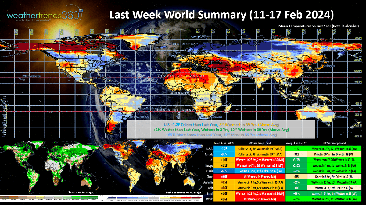
Last week (11-17 Feb '24) across the World shows the U.S. trending -1.2F colder than last year, 8th warmest of the past 39 years. Rainfall up +1%, wettest in 3 years and 12th wettest of the past 39, while snowfall was up +69% vs last year and 19th most of the past 39 years. Russia was the cold spot while China was the hot spot.
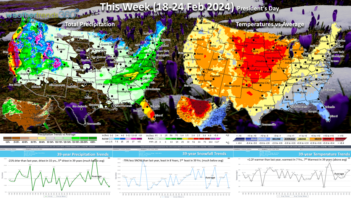
This week (18-24 Feb) shows a moderating trend with a big warm up in the Central U.S. U.S. temperatures trend +2.2F warmer than last year, warmest in 7 years and 7th warmest of the past 39 years. The East trends much cooler than last year. Rainfall -21% vs a year ago, driest in 15 years and 5th driest of the past 39, while snowfall is down -79%, least in 8 years and 3rd least in 39 years. TBD as models are not handling snow events well even a few days out. Still some risk for another snow event next weekend in the East.
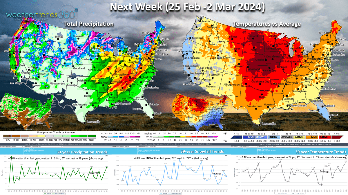
Next week (25 Feb - 2 Mar) A stormy week with rainfall up +36% vs last year, wettest in 6 years and 6th wettest in 39 years, while snowfall is -28% less than a year ago and 20th least of the past 39. Temperatures are +3.1F warmer than last year making it the warmest in 24years and 2nd warmest in 39 years. But signs of colder weather returning for the early to middle March period.

The Polar Vortex does look to wobble again with the brutally cold air currently in Central Siberia advancing to Northeast Siberia and Alaska with some of this slowly moving back into the U.S. by early March.

The World 2-week outlook (18 Feb -2 Mar) shows the PV moving toward China and Alaska keeping it very warm in Europe, the U.S. and Canada.
The pattern does look stormy for many areas, so the threats for bigger snowstorms are not over.
We end today's video with a time-lapse of the heavy snowstorm as it traversed through Eastern PA last night. Have a great week ahead and don't forget to follow us on social media for frequent updates: Facebook, Twitter, YouTube, Pinterest and Linkedin.
- Captain Kirk out